
|
|
Mountain/Rock |
|---|---|
|
|
41.18600°N / 113.3675°W |
|
|
Box Elder |
|
|
Hiking, Scrambling |
|
|
Spring, Summer, Fall, Winter |
|
|
7005 ft / 2135 m |
|
|
Overview
Desert Peak is a rugged, unknown, yet spectacular peak in the west desert of Utah. It is the highest mountain in the Newfoundland range. The Newfoundland range is part of the western Utah desert and is located about 3/4 of the way from Salt Lake to Wendover and about 30 miles north of I-80. Most days Desert Peak can be seen from I-80 and on really clear days it can be seen from spots in Salt Lake Valley. Viewed from a distance, the peak is light-colored and looks very rugged and "pointy" towards the top.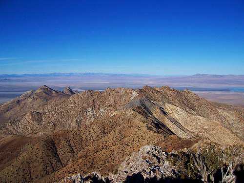 Summit View North
The Newfoundland Mountains are not easily accessed and though Desert Peak is a mere 30 miles from the interstate, it will require around 2 hours to get to the start of the hike. The very southern part of the Newfoundland Mountains is actually in a military area and no public access is allowed. But the difficulty in getting there is re-payed in the vast remoteness, historical charm, and jagged peaks. Desert Peak and the Newfoundland Mountains are also part of the Newfoundland Mountains Wilderness Study Area and sports a healthy population of big horn sheep. A trip to the Newfoundland Mountains is a excellent experience for it's solitude and beauty.
Desert Peak rises about 2800 feet from the surrounding Salt Flats and ranks as #46 for Utah Peaks with 2000 feet or more of prominence. Click here for a list of Utah Prominence peaks.
There is a still-distinct 1847-50 wagon trail just to the south called the Hastings Cut-off. To the north there's the Transcontinental railroad bed that is fun to see. It's 1904 replacement is the route you use, at least the dirt road next to it, to access the Newfoundland range. There is lots of old mining activity to see. The mine at the head of Dell's Canyon has a cablecar ore shuttle system that looks like it's still in working order.
The actual climb is steep but not difficult except as you approach the top the footing gets loose and there is more exposure. The top is a series of jagged spires. The 360 degree views are spectacular.
 |  |  |
Routes Overview
There are basically two ways to hike this mountain: East side and West side. The east side approach uses Dell Canyon to ascend the mountain, the west side uses the Southwest ridge.Compared to the Southwest ridge, Dell's Canyon is more difficult in terms of elevation gain, route finding and being more technical. Mileage wise, both are about the same. If driving high clearance, the Dell's Canyon will be about 300 more feet of vertical. Route finding will be required if coming from Dell's Canyon as there are several cliffs to bypass. So if you want more of a challenge, take the Dell's Canyon side, it also was quite scenic, though I can't comment on the west side approach.
Getting There
The two driving options mentioned are the only two ways to access this mountain range that I am aware of. From Grouse Creek and Lucin (west) there is supposedly a gate that is locked and there is no public access.To get to the Newfoundland Mountain access road from the railroad tracks does not require high clearance or 4WD. As soon as you leave the railroad tracks the road is rutted and you may not be comfortable driving a sedan on this part of the road, though I did with a Mazda and had no problems. Once you reach the mountains the road is in good shape and will only require 4WD or high clearance if there have been recent storms. Of the two options mentioned I would recommend taking the route from Salt Lake City as the roads are in good condition. The other route is much longer (from the Wasatch) and I don't have personal knowledge of this route.
 Desert Peak and the Newfoundland Mountains from Floating Island
From Salt Lake City: (120 miles)
Head west on I-80 towards Wendover. Continue to exit 62 (Lakeside Military Area) and head north towards the Military Area. About 15 miles from the Interstate you will reach the Military Area where the paved road bends and then continues to the military base. At this bend there is a dirt road that continues straight, follow this well-graded dirt road. After another 14 miles you will reach the railroad tracks. Continue about a 1/4 mile west to where a road crosses the tracks and follows the railroad tracks. This is where the road is marked as private. Continue west along the railroad tracks for 25.5 miles to the Newfoundland Mountains road.
From Highway 30: (70 miles)
From the large bend in highway 30, shown here head 6.5 south towards Kelton on a dirt road. At Kelton take a right and go 2.8 miles to a dirt road that breaks off and heads south. Follow this road for approximately 23 miles to an intersection and then go right the road soon heads west then southwest. From 5.4 miles from the previous intersection there is another intersection. Go left, then you will soon go straight through an intersection then south for 7 miles to the railroad tracks. Now travel west along the railroad tracks for 12.5 miles to the Newfoundland Mountains road.
Once at the Newfoundland Mountains road:
For Dells Canyon approach:
Head south along the rutted and washed out road for approximately 2 miles where you reach an intersection. Continue straight for another mile to where you reach a T intersection. Go left and around the mountain range. Once you are around the side of the range and heading south again it is approximately 6.5 miles to Dell's Canyon. This stretch of road has occasional mud and washout but is in generally good condition.
For the Southwest Ridge:
See the Southwest Ridge page.
Red Tape
 Railroad sign.
Inside the Newfoundland Mountains Wilderness Area, please follow the rules. The road alongside the railroad is signed as private property and no tresspassing. However, there are no gates (as of 11/25/2006) and to access this mountain range you must use this road. The BLM encourages hiking, sightseeing, and wildlife viewing in the area.
When To Climb
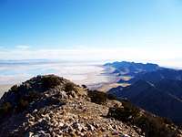 View South from the summit
Fall, Winter and Spring would be the best times to do this hike. Though the route up from Dell's Canyon faces to the north, expect some snow aftert recent storms and cold spells. During the summer months expect daytime highs in the 90-100's.
Sp Member Varleys writes: I climbed on a June weekend and camped in one of the canyons. It was cool on the mtn. I did not find any water while I was there but there are supposed to be 2 springs toward the south. Spring and Fall would be good times to climb. I expect it could be climbed in the winter.
Camping
This terrain is vast open desert surrounded by salt flats. Primitive camping is allowed. There are no nearby campgrounds or developed campsites. Make sure you have gas, the closest gas station is 70 miles away in Delle (exit 70 off I-80) and bring plenty of food, water and firewood.One of the better places to camp is located at the northern end of the Silver Island Mountains and access is relatively easy. To get there from the train tracks: Continue south towards the Silver Island Mountains, at 2 miles there is an intersection, continue straight. Then continue for another mile to a T-intersection, go right (west) towards the large granite outcrop and continue for another 1 and 1/4 miles to the end of the road.
Additional Information
Geocacher's have placed caches in the area. You can follow these GPS coordinates to their caches or go to Geocaching.com and search for these cache names or just look at the map of caches in the area of the Newfoundland mountains. They also have information about getting there and camping.Newfoundland First
N 41° 11.624 W 113° 21.580
Newfoundland Hilton
N 41° 11.085 W 113° 22.751
gjagiels - Apr 29, 2009 1:59 pm - Hasn't voted
Re: Access from the southThanks for the info, I didn't think it was accessible from the south. I have also heard if you try to drive around the southern tip of the range, it is fenced with no way around.
ridgeguy - Aug 19, 2009 11:05 pm - Voted 10/10
Re: Access from the southTurns out you can access from the south as Dean did it this week. In daylight, I guess I would have noticed a road branching off to the right before hitting the military base.
gjagiels - Aug 20, 2009 11:44 am - Hasn't voted
Re: Access from the southOk, you're talking about accessing Lakeside from the south, yes it is most definately doable. I thought you meant coming into the range directly from the south. On the page I mentioned the pavement ends, which it doesn't it goes into the military base and that dirt road branches off to the right. I'll change it, thanks! Greg
voxnihili - Jan 15, 2012 12:46 pm - Hasn't voted
Road LocationA heads-up for those planning their trip using a topo map. The Newfoundland turnoff from the railroad road is about 1.4 miles west of where it appears on the map. It's hard to miss but for reference, it is located at 41.28487 N, 113.34727.
1L-19 - May 6, 2017 11:58 am - Voted 8/10
Re: Road LocationYes, that is exactly right. The crossing shown on the topo map has all kinds of problems. When I was out yesterday, there was water on both sides of the road where that crossing is, it's essentially a raised berm. I walked out onto it and it was waterlogged sand and very unstable. There was no way I was going to drive on that. Even without those problems, how the heck would I get my RAV4 over those railroad tracks anyway? Maybe in a large truck but my crossover SUV wasn't going to make that. That's all you need, getting stuck on the tracks with a train coming, and out in the middle of nowhere! Anyway, I kept driving west hoping to find another crossing. I did at 41.28487 N, 113.34727 W. It worked great, no problems.
1L-19 - Aug 6, 2017 9:38 pm - Voted 8/10
Route notesI took the south route via the Military Area and it was a real eye-opener. This webpage treats the two routes as basically equivalent and that's not the case at all. I think it needs to be presented from the standpoint: do you want to take a route where you can make good time or do you want to take a route that is rougher, slower, and more adventurous? If you want to make good time and take a route that's 80% paved highway, take the route through the military area. That road is paved nearly all the way to the railroad causeway. Even when you leave the pavement (at the fork where you have the choice of continuing on to the military base gate or going through to the railroad causeway), the road is so wide and well-maintained that you can do 50 MPH easily except for a few curves where you'll need to slow down to 35 or so. Just before the railroad tracks, you need to navigate a large mine. Continue north as far as you can, turn left (west) and continue for about 1/4 mile. You'll see a place to cross the railroad tracks. About the mine: the signs are worded strongly and it seems pretty evident that they don't want you there. There aren’t any no-trespassing signs (I think because they have to let people through). Coming through on a Saturday, I was not at all certain that it is an operating mine anymore, there were only 2-3 pieces of heavy equipment, there were no people visible, and everything appeared shut down. I’m sure you’ll be fine as long as you stay clear of any heavy equipment and move through as expeditiously and unobtrusive as possible, nothing new about this concept. The northern route is a spiderweb of dirt roads. I would strongly advise that you map out a route on Google Earth. Being dozens of miles out of cell-phone range, this is not a place that you want to get lost. The route closest to the lakebed (farther east) is scenic and passes cool rock formations but it is a lot more narrow, potholed, and slow so you'll want to decide if you want a more scenic route or faster route from the north.