
-
 47941 Hits
-
 85.87% Score
-
 21 Votes
|
|
Mountain/Rock |
|---|---|
|
|
43.59885°N / 115.42881°W |
|
|
Hiking, Mountaineering, Trad Climbing, Scrambling |
|
|
Summer, Fall |
|
|
9536 ft / 2907 m |
|
|
Overview

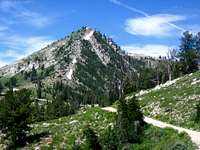
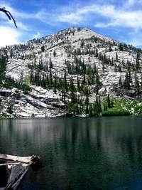
As the highest peak in the Boise Mountains with a lookout tower, Trinity Mountain is one of the premier peaks in the range. Similar to Steele Mountain, Trinity has a steep and impressive north side with alpine and technical climbs. Trinity Mountain is often snow bound well into June and the campground road usually doesn't open until July. More than 15 lakes are scattered mostly north and east of the peak and provide great backpacking, fishing, and hiking destinations. Big Trinity Lake and Little Trinity Lake contain drive in campgrounds and the scattered lakes in the region is a rarity by Boise Mountain standards.
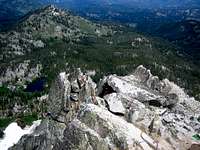
As the tallest peak for it's latitude in the area (how far south it is), Trinity provides an excellent and relatively close mountain destination. The summit lookout tower is still considered active and is utilized during fire season. The tower sits precipitously on the edge of the north sheer rocks and the steep slopes below contain historic trash from the days of throwing garbage over the sides. The scramble or climb up the north face is challenging and is only surpassed by Steele Mountain in terms of quality of rock and snow for this mountain range.
Routes
Trails from Big Trinity Lake and Campground : Follow the well marked trails from north of the peak over a prominent saddle and past many lakes on the east side of the peak. Take the rugged, rough and rocky ridge up the south side of the peak.
4.9 miles and 2475 feet elevation gain (one-way)
Jeep Road: From the prominent saddle and closed gate follow this road to the summit
2.4 miles and 1400 feet elevation gain (one-way)
North Side Couloirs and Face Climbs: From near Fiddle Lake or Big Lost Lake, ascend one of many snow couloirs (early season May-June) or the Class 3-4 ridges that run steeply up the north side.
0.6 miles and 1200 feet elevation gain (one-way)
Complete Traverse and Summit: Follows most of the rocky ridges on the north side (Point 9183) and east side ridges. Start at the saddle near the locked gate and follow the ridge over Point 9183. From here scramble east to the prominent saddle and catch the trail. Follow the trail up to Heart Lake and scramble to the south ridge. From the summit lookout follow the Jeep Road down to the saddle.
7.0 miles and 2970 feet elevation gain (one-way)
Activity Matrix

| Activity | Rating 1-10 | Required Experience |
| Rock Climbing | p | intermediate |
| Alpine Climbing | 6 | intermediate |
| Hiking / Scrambling | 7 | intermediate |
| Trail Running | 7 | beginner |
| Mtn Biking | 0 | n/a |
Key:
p=potential, but unknown
Getting There
From ID-20 northeast of Mountain Home, Idaho turn left onto the Fall Creek Road just past Dixie Summit and before Cat Creek Summit. Follow the road (paved at first) to Anderson Ranch Dam at 5.3 miles. Follow the road along side Anderson Ranch Reservoir for 9.3 miles until it becomes Fall Creek. Follow Fall Creek for 6.4 miles and bear right and follow signs for Trinity Ridge. After 8.9 miles you'll pass Cold Spring Campground and the road climbs up to a prominent ridge northwest of the peak. Park near here with a view of the Jeep Road that climbs to the lookout tower or descend down to the alpine lakes and campground north of the peak.
Conditions
Boise National Forest Site
http://www.fs.fed.us/r4/boise/
Nearest SNOTEL site gives latest snow depth readings:
Trinity Mountain SNOTEL Site