
-
 8216 Hits
-
 92.32% Score
-
 38 Votes
|
|
Mountain/Rock |
|---|---|
|
|
47.40817°N / 10.34457°E |
|
|
Hiking |
|
|
Spring, Summer, Fall, Winter |
|
|
6381 ft / 1945 m |
|
|
Overview
 The Hüttenkopf summit in front of the Kleinwalsertal Valley mountains The Hüttenkopf summit in front of the Kleinwalsertal Valley mountains |
Hüttenkopf is a minor but nevertheless spectacular looking summit in the Daumen Group of the Allgäu Alps. It is located south of Nebelhorn on a ridge which connects Schattenberg in the south-west with Zeiger, its immediate neighbour to the east. Hüttenkopf is what we call “Grasberg” a grass covered mountain, with very steep slopes to either the northern and southern sides. In the vicinity of Hüttenkopf the ridge turns razor-sharp and the summit is little more than a series of bumps. In this respect Hüttenkopf is a typical mountain of the Allgäu Alps, where you often find long, grassy ridges, out of which formidable limestone and dolomite towers rise.
 |  |  |
On the other hand when seen from up close the steepness of the slopes and the fact that the risdge turns to the south-west right at the summit make Hüttenkopf one of the most beautiful sights in the region. The summit appears to tower above the Trettach-, Stillach-, and Breitach-Valleys where the rivers combine to form the Iller River north of Oberstdorf. On a clear day the mountains of the Kleinwalsertal Valley form a perfect backdrop to the mountain. While Hüttenkopf is a sight to see in spring and summer – with lots of flowers on its steep grass slopes, it shows its real beauty in winter, when snow banks and seracs reshape the summit, accentuating its form.
 |  |  |
Hüttenkopf is one of the easiest mountains to get to in any season. A hiking trail connects the second cable-car station of the Nebelhornbahn cable-car with Zeigersattel, the saddle between Zeiger and Hüttenkopf. The hike takes little more than 20 minutes, even in winter, when the trail gets cleared as a so-called “winter hiking trail” (if conditions allow that is). From Zeigersattel a short hike brings you to the start of the knife-edged ridge. The first few bumps on the ridge are easily traversed but the next couple, among them the highest point of Hüttenkopf require some experience as they are greatly exposed on their northern sides.
Summit Panorama
KrottenspitzenFürschießerKratzerTrettachspitzeHochfrottspitzeBockkarkopfWilder MannHohes LichtRotgrundspitzeLinkerskopfBiberkopfWildgrundköpfeHüttenkopfHahnenkopfRiffenkopfSeeköpfelSchafalpenköpfeKemptener KopfWidderstein 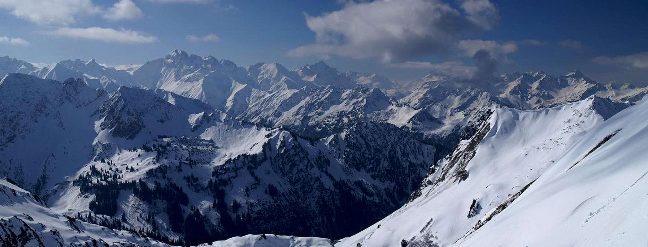  |
Getting There
 |
Oberstdorf is located in a dead end valley in the midst of the Allgäu Alps. The closest airports are at Munich and Stuttgart, cities which are connected by motorway A8. Quite central between the two cities there is the intersection "Ulm-Elchingen" from where motorway A7 leads southward in direction of the Allgäu Alps. South of Kempten take A980 west, which ends after a couple of miles/kms where you have to switch to B19 south. This highway takes you all the way to Oberstdorf, where you can find the Nebelhornbahn cable-car right in the centre of town.
Red Tape
Riedberger HornGeißalphronGeißfußGrundkopfNebelhornWestl. WengenkopfÖstl. WengenkopfGratkopfGroßer Daumen 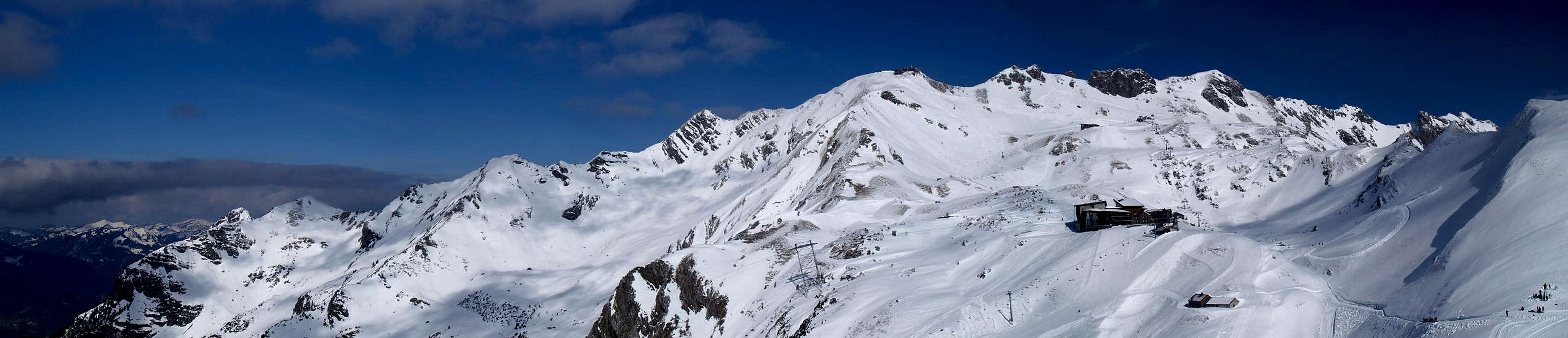 |
The whole Daumen Group is part of the natural preserve "Naturschutzgebiet Allgäuer Hochalpen". The usual rules apply - don't disturb wild animals, don't collect any plants, stay on the marked trails. Dogs should be kept on leash. These rules seem to be rather outdated when you see the brouhaha around the Nebelhorn cable-car stations. But remember, that parts of the group still are remote and can be solitary.
Parking lots: you have to pay for almost all parking lots in Oberstdorf. There is a large unguarded one to the south of the cable-car which is (still) free of charge. The Nebelhornbahn cable-car is very expensive, especially if you want to go all the way to the top. There is an alternative by climbing to Zeigersattel from the Oytal Valley but in winter the trails are closed.
Accommodation
You can choose between campgrounds, farm holidays, vacation homes and hotel rooms on most of the sites of the Allgäu villages. A good starting point for your search is:Weather Conditions
IfenspitzenRauheckKreuzeckKl. HöfatsGr. KrottenkopfHöfatsKrottenspitzenFürschießerKratzerTrettachspitzeHochfrottspitzeBockkarkopfWilder MannHohes LichtRotgrundspitzeLinkerskopfBiberkopfHüttenkopfSeeköpfelSchattenbergGrundköpfeSchafalpenköpfeKemptener KopfWiddersteinKanzelwandFellhornLechquellengebirgeWallmendinger HornHoher IfenGottesackerwände 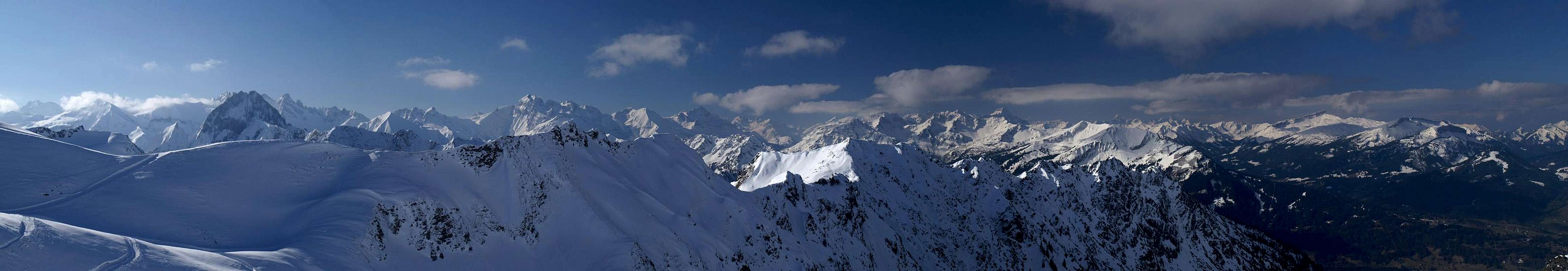 |
All of the towns and villages of Allgäu have their web sites, most of them with weather information and live cams. Here is a small selection

Maps & Books
Maps- Allgäuer Alpen / Kleinwalsertal
1:50000
Kompass Map WK 3
Kompass Verlag
ISBN: 3-85491-005-3
- Alpenvereinskarten : Allgäu-West
1:25000
Deutscher Alpenverein
ISBN: 3928777130
Books
- Allgäuer Alpen und Ammergauer Alpen Alpin
D. Seibert
Alpenvereinsführer
Rother Verlag
ISBN: 3-7633-1126-2
- Allgäu 1 - Oberallgäu und Kleinwalsertal
D. Seibert
Rother Verlag
ISBN: 3-7633-4289-3