
|
|
Mountain/Rock |
|---|---|
|
|
53.00311°N / 4.13635°W |
|
|
Gwynedd |
|
|
Hiking, Mountaineering, Trad Climbing, Bouldering, Scrambling |
|
|
Spring, Summer, Fall, Winter |
|
|
2569 ft / 783 m |
|
|
Overview
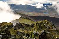
Moel Hebog (Hill of the Hawk/Falcon) is located just west of Snowdon, only a short walk northwest of the village of Beddgelert. Its steep rocky summit dominates the view from the village and is also an impressive part of the vista enjoyed from Snowdon's summit. In turn, on a clear day, Moel Hebog offers superb views of the Snowdon range, and an excellent position to grab a quality photograph of Wales' highest mountain. Although the mountain appears steep and rocky from the west, its eastern flank has a much shallower gradient, rising slowly from the Dwyfor Valley, and offers a much easier ascent. Climbing the mountain is usually incorporated into a longer traverse over Moel yr Ogof (Hill of the Cave) (655m) and Moel Lefn (Smooth Hill) (638m) to the north, and even the Nantlle Ridge for those looking for a long day of walking. The former hill, Moel yr Ogof, is thought to conceal a cave where Owain Glyndwr, who led the last Welsh revolt between 1400-1415, hid after disappearing following the rebellion's failure. When approaching from the west, an easy scramble near the summit can be incorporated into the walk, and although the scramble is easy, there is a lot of loose rock and in wet weather it can be very slippery. |
 Moel Hebog from Beddgelert Moel Hebog from Beddgelert(Photo by Bryan Benn) |  The slightly uninspiring summit The slightly uninspiring summit(Photo by Nanuls) |  Moel Lefn and Moel yr Ogof Moel Lefn and Moel yr Ogof(Photo by Nanuls) |
Rock Climbing
Due to its marginal position and the vegetated and broken nature of the crag, Moel Hebog receives relatively few visits from climbers. The mountain's climbing is split between three areas – The Summit Crags, Diffwys and y Braich. Climbs are listed, graded and rated with the aid of the Climbers’ Club Guide to Cwm Silyn and Cwellyn (Eifionydd) by Paul Jenkinson and Bob Wightman, so for full descriptions, please refer to this book. Routes are graded using the British Adjectival Grading System. Technical grades are generally only given to climbs graded adjectivally as Severe (S) or above. A conversion table of international climbing grades by SP member Corax is available HERE! Bolting is strictly prohibited on the crags listed here. With the exception of Y Braich, all routes are described from left to right. Route Symbols:
The Summit CliffsAs the name might suggest, these rather broken crags (SH 567 467) can be found just below the summit overlooking Cwm Cyd. Legend has it that they are home to Britain's oldest climb, Glyndwr's Ladder (Easy), which was used as an escape from the perusing English by the Welsh rebel, Owain Glyndwr in around 1400. |


| No. | Name | Length | Pitches | Adjectival Grade | Technical Grade | Quality | Restrictions |
|---|---|---|---|---|---|---|---|
| 1. | Pursuer's Folly | 72m | 4 | VD |  | | |
| 2. | Glyndwr's Ladder | 75m | E | | | ||
| 3. | Wish I Could Be Elsewhere | 45m | 2 | VS | | | |
| 4. | May Rib | 46m | D | | |


Y DiffwysThe east facing crags of Y Diffwys (SH 567 476) on the western side of Moel Hebog offer around 10 multi pitch routes graded from V Diff to HVS, and have a height of around 150 metres. Unfortunately the crag is heavily vegetated and hard to access. Y Diffwys |
| No. | Name | Length | Pitches | Adjectival Grade | Technical Grade | Quality | Restrictions |
|---|---|---|---|---|---|---|---|
| 5. | Omega | 105m | D | | | ||
| 6. | Bending Groove | 135m | VD | | | ||
| 7. | Anaconda | 115m | VD | | | ||
| 8. | Caterpillar | 115m | VD | | | ||
| 9. | Lodestone | 90m | D | | | ||
| 10. | Tension Crack | 80m | 4 | S | | | |
| 11. | Compression | 130m | 3 | VS | | | |
| 12. | Ignition | 102m | 4 | VS | | | |
| 13. | Redog | 58m | 2 | HVS | 5a |  | |
| 14. | Flashback | 61m | 2 | HVS | 5a | | |
| 15. | Chinaman | 126m | 3 | VD | | | |
| 16. | Maiden Gully | 130m | 5 | S | | | |
| 17. | Maiden Buttress | 135m | 6 | D | | | |
| 18. | Pink Slab | 120m | S | | | ||
| 19. | Two Chimney Route | 90m | VD | | | ||
| 20. | Explorers' Traverse | 175m | 8 | D | | |
The Rock of Ages This little crag lies just below Y Diffwys on the northern slope of Cwm Bleiddiaid. It is home to some excellent rock which reaches around 12 metres at its maximum. It is split at its centre by an obvious chimney, which can be climbed at Diff standards. Other routes, all of which are single pitch, include Terry's Rump (E1 5b), The Handcrack (VS 4c), The Wall (VS 4c) and the Fingercrack (HVS 5b). |


Y BraichThe crags of Y Braich (SH 567 483) lie on the north-western side of a ridge also known as Y Braich, which runs north-east from Moel Hebog's summit. It's low altitude and good drainage make it an ideal wet weather venue. Routes are described from right to left. Y Braich |
| No. | Name | Length | Pitches | Adjectival Grade | Technical Grade | Quality | Restrictions |
|---|---|---|---|---|---|---|---|
| 21. | Deaf School | 23m | 1 | S | | | |
| 22. | Buzzard Groove | 23m | 1 | VD | | | |
| 23. | Natty Dread | 23m | 1 | S | | | |
| 24. | Birth of Gravity | 23m | 1 | HVS | 5a | | |
| 25. | No More Gain | 23m | 1 | HVS | 5a | | |
| 26. | Not Taylor Made | 23m | 1 | E2 | 5c | | |
| 27. | Wild Wind | 23m | 1 | S | | | |
| 28. | Talaq Talaq Talaq | 14m | 1 | E1 | 5b | | |
| 29. | Tropical Rain Rib | 14m | 1 | VS | 4b | | |
| 30. | Dark Summer | 23m | 1 | HVS | 5a | | |
| 31. | Song for a Taylor | 21m | 1 | S | 4a | | |
| 32. | Spectrum | 21m | 1 | S | 4a | | |
Y Braich Bach |
| No. | Name | Length | Pitches | Adjectival Grade | Technical Grade | Quality | Restrictions |
|---|---|---|---|---|---|---|---|
| 33. | No More Flaying | 13m | 1 | VS | 4c | | |
| 34. | no More Slaying | 13m | 1 | VS | 5a | | |
| 35. | Ni Ydy'r Indians | 13m | 1 | E1 | 5b | | |
| 36. | Fair and Squaw | 13m | 1 | VS | 4c | | |
| 37. | Tomahawk | 13m | 1 | VS | 4c | | |
| 38. | Ar y Drwm | 13m | 1 | HVS | 5b | | |
| 39. | No More Playing | 13m | 1 | VS | 4c | | |
| 40. | More to Gain | 13m | 1 | VS | 5a | | |
Winter Climbing
Moel Hebog currently only has one winter line of any note, located on Y Diffwys. Companion's Way is a Grade II, steep rake that runs around 100m from left to right across the centre of the crag. Descent can be achieved easily at the southern end of the crag, although to be fair, your better off carrying on to the mountain's summit. For more information see Cicerone's Welsh Winter Climbs by Malcolm Campbell and Andy Newton. |
Mountain Conditions
This section displays the mountain conditions for Snowdonia, of which Moel Hebog is part. Click on the widget for maps and further information. This Snowdonia weather forecast is generated by the Met Office Weather Widget |
When to Climb and Essential Gear
The most reliable conditions are in the summer. The gear needed depends entirely on the routes you plan to do. A hike will require all the gear normally require for a hike in Wales, remember this Snowdonia so be sure to pack full waterproofs. Easier scrambles and rock routes will only require a moderate rack, while longer harder routes will require a full rack with a good compliment of cams. A singe 60 metre rope should serve well on most routes, however, twin or double ropes would be a wise choice for the harder stuff. |
Getting There
Moel Hebog (SH 559 533) can be reached from the A4085, which runs between Caernarfon to Penrhynddeudraeth; parking is available at Beddgelert (SH 590 481) and Rhyd-Ddu (SH 571 525). Rhyd-Ddu can also be reached on the Welsh Highland Railway, which is a steam train that runs from Caernarfon. The railway has now been extended from Rhyd-Ddu to Porthmadog with stations at Beddgelert, which is very handy for getting to the bases of both Moel Hebog and Snowdon. |
Red Tape and Access
No red tape or access issues here! For climbers, hill walkers and mountaineers, the British Mountaineering Council (BMC) runs a Regional Access Database, which holds mountain/crag specific information on matters of conservation and access, including issues such as nesting restrictions, nature designations and preferred parking. If you are in any doubt about any particular access arrangement, or need to report an incident, you should contact your local BMC Access Representative or the BMC Access Officers for Wales: Elfyn Jones. |
 From Snowdon From Snowdon(Photo by Bryan Benn) |  Moel Hebog Moel Hebog(Photo by Nanuls) |  Moel Hebog Moel Hebog(Photo by Nanuls) |
Camping and Accommodation
There’s an almost unlimited supply of accommodation within the Snowdonia National Park so it would be inappropriate to list it all here. For budget accommodation it’s worth checking out some of the following sites: Youth Hostel Association in WalesIndependent Hostel GuideCampsites in Gwynedd |
Maps
Guidebooks
|
|


External Links
 Moel Hebog from the Nantlle Ridge (Photo by Nanuls) Moel Hebog from the Nantlle Ridge (Photo by Nanuls) Snowdon from Moel Hebog (Photo by Nanuls) Snowdon from Moel Hebog (Photo by Nanuls)Government Bodies and Official Organisations Snowdonia National Park Authority Association of National Park Authorities Royal Commission on Ancient & Historical Monuments in Wales Hiking, Climbing and Mountaineering Organisations and Companies British Mountaineering Council Plas y Brenin National Mountain Centre Weather Tourist Information North Wales Tourism Partnership Local Information from Gwynedd.com Local Information from Snowdonia Wales Net Travel Welsh Public Transport Information Accommodation Youth Hostel Association in Wales Maps and Guidebooks Cordee Travel and Adventure Sports Bookshop Wildlife and Conservation |