
-
 6320 Hits
-
 78.27% Score
-
 9 Votes
|
|
Mountain/Rock |
|---|---|
|
|
42.79688°N / 0.12840°E |
|
|
Hiking, Mountaineering |
|
|
Spring, Summer, Fall, Winter |
|
|
9862 ft / 3006 m |
|
|
Overview
 Estaragne
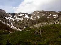
The massif of the Pic Long presents a little range to the west with two important peaks, the rocky one Estaragne (3,006m) and the higher one Campbieil (3,173m). Although Campbieil is probably the most climbed peak of the zone after the Néouvielle, Estaragne is climbed in many occasions in combination with it specially if it's desired to carry out a route in circle. The peculiarity of the Estaragne is that possesses its own route by the valley of Estaragne, completely separated of those of the remainder of the massif without being necessary to cross the lake of Cap of Long.
The normal route don't have technical difficulties but it exists another route across the North ridge with grade F+ exposed. The confusion is frequent in the Col d'Estaragne and it's necessary many attention in this point to find the normal route after a little descent, because the ridge is impressive for the hikers and begginers.
 Alharisses
 Estaragne
In many maps appears the denomination Pics d'Estaragne (Peaks of Estaragne). Really the only one summit over 3000m, and the most popular is called Estaragne but it's a long ridge with another peaks in the north generally calleds Ridge of Alharisses. The Grand Pic d'Alharisses (2,993m) is a great mountain with impressive walls for rock-climb but it's not a three-thousand. The normal route of this peak is A.D.inf. (III-). In the ridge NE exist a little summit of 2,959m as well, the route of this ridge cross over it.
 |
 |
 |
Getting There
 East face
From France:
-west and NW: Pau, Tarbes and we'll take the exit in Lannemezan to Arreau, St Lary Soulan (indication Tunnel de Aragnouet-Bielsa Espagne). D929 to St Lary and before Aragnouet in the village of Fabian is the road to Lac d'Oredon and Reserve Nature de Néouvielle. In the crossroad of the lakes we'll follow in left side to Cap de Long (right is to Lac d'Oredon and Lac d'Aubert).
-east or NE: Toulousse, from Toulousse in direction to Tarbes but in Lannemezan we'll take the same road.
From Spain:
-west and NW: go to France across Irun and take the road to Pau-Tarbes and we'll follow the same itinerary of west of France. It's longest but it had good highways (pay). It's possible the shortest route in direction to Huesca but you had some cols and the road is not highway.
-South, East: we'll go to province of Huesca. N240 to Barbastro and Ainsa. A138 to Bilesa. Across tunnel Bielsa-Aragnouet we'll entry in France. After the village of Aragnouet we'll reach Fabian.
Red Tape
The Nature park of Néouvielle is a great area with rules for the accesses, activities and places of camping.Camping
The places of camping permitted, withdrawing the tent at the morning, they are found properly indicated.In Cap of Long, near of trailhead of Estaragne, it don't exist places of camping, but we can spent the night in caravan or in vehicle or even in vivac in summer.
Further down in the road is found the free zone of camping of the Lac d'Orédon although the parking is of payment. In this place is the barrier to access to Lac d'Aubert, closed in summer from 9:30 to 18:00, but it don't exists routes to Estaragne from this side. It exists another free camping area in the Lac d'Aubert.
Of course is possible to lodge in the refuge-chalet of Lac d'Oredon or the villages as Aragnouet, Fabian, St Lary Soulan,
External Links
mendiak: estaragne+campbieil very good indications with pictures across ridge of cintes blanques (text in Spanish)esquidetravesia.net: estaragne ascension with sky-cross county.
komandokroketa.org: estaragne, ascension with sky-cross county.