
-
 11405 Hits
-
 88.61% Score
-
 27 Votes
|
|
Mountain/Rock |
|---|---|
|
|
47.20686°N / 10.36835°E |
|
|
Hiking |
|
|
Spring, Summer, Fall, Winter |
|
|
9498 ft / 2895 m |
|
|
Overview
 Kaisers (05-08-2007)
Holzgauer Wetterspitze is the highest summit in the Wetterspitze group of the Lechtal Alps and one of the highest mountains of the Lechtal Alps. The summit block is a bold spire which looks very difficult to overcome. For those who can manage UIAA grades I and II (class 3 and 4 climb) Holzgauer Wetterspitze is an absolute highlight summit of the Lechtal Alps.
The Wetterspitze group is situated in the western parts of the Lechtaler Alps and has some of the highest mountains of this beautiful part of the Norther Limestone Alps.
Holzgauer Wetterspitze is located north of the Lechtal main ridge in a south - north - running subridge, limited by Sulzeltal to the west and Grießltal to the east, two southern side valleys of the Lechtal main valley. This subridge starts at Vorderseespitze (2874 m) and goes to Feuerspitze (2852 m), Holzgauer Wetterspitze (2895 m), Etlerkopf (2693 m), Pleiskopf (2656 m), Muttlerkopf (2617 m), Tajaspitze (2509 m), Hinterer Sonnenkogel (2324 m) and Vorderer Sonnenkogel (2204 m).
 Upper Kaisertal(05-08-2007)
 Upper Kaisertal(05-08-2007)
The main cols in this ridge are Stierlahnzugjoch (2596 m) between Feuerspitze and Vorderseespitze, Fallenbacher Joch (2753 m) north of Feuerspitze with the ascent trail to Holzgauer Wetterspitze and Lahnzugjöchl (2585 m) between Feuerspitze and Aples Pleisspitze.
Getting There
 Below Lahnzugjöchl (05-08-2007)
 Summit from Stierlahnzug (05-08-2007)
You start your hike for Holzgauer Wetterspitze normally from Kaisers or from the little village of Sulzelbach / Lechtal.
Road Nr. 198 from Reutte / Tirol or from Sankt Anton / Arlberg, goes through Lechtal.
Sulzelbach is located between Holzgau and Stockach.
For Kaisers leave road nr. 198 at Steeg / Hägerau in the Lechtal and follow the road up to the little mountain villages. Parking areas are near Edelweißhaus.
There is a public bus service operating in Lechtal (see schedule here).
The next railroad stations are at Reutte or at Sankt Anton / Arlberg (see ÖBB schedules).
As the Lechtaler Alps are a good region for several days hike, going from hut to hut, Holzgauer Wetterspitze can be climbed from Kaiserjochhaus and Ansbacher Hütte; too. Both alpine club mountain huts are located on the main ridge of the Lechtaler Alpen and are connected by great hiking trails.
Red Tape
 Wool gras meadow and Vorderseespitze (05-08-2007)
No restrictions or fees as far as I know.
Holzgauer Wetterspitze is mainly a summer and autumn hike. In winter and mainly in springtime Holzgauer Wetterspitze is an interesting ski hike, too.
In summertimes full hiking gear and goot hiking boots are required.
For a ski hike you need full equipment and you avalanche gear.
Check the weather forecast here.
Check the avalange bulletin here.
Routes & Trails
 At Fallenbacher Joch(05-08-2007)
 At Lahnzugjöchl (05-08-2007)
Holzgauer Wetterspitze is summited mainly from Frederic-Simms-Hütte. This ascent can be made as a very long and very strong day hike, too.
Other possibilities are routes starting from Kaisers / Edelweißhaus, Ansbacher Hütte and Kaiserjochhaus.
Route from Frederic Simms Hütte
Ascent to Frederic Simms Hütte
Trail number 636 starts at Sulzelbach. Follow the forest road into Sulzeltal. It overcomes the first steep slope on the west side of the Sulzelbach Canyon. You have to traverse a long tunnel, don´t forget a torch light(!).
Alternatively there is a steep trail running through the canyon and ascending steeply the west side of the canyon up to the forest road where it enters the upper Sulzelbachtal.
The road passes Sulzelalm and Ronigalm and ends at the valley station of the Frederic Simms cableway (only supply transportation).
Use the trail zigzagging up to the visible hut, standing high above the valley at the end of the northwest arete of Holzgauer Wetterspitze.
 Western Lechtal peaks (05-08-2007)
 Allgäu peaks (05-08-2007)
Route from Frederic Simms Hütte
From the hut simply follow trail number 636 up the steep slopes of the upper end of Sulzeltal. After some zigzags you reach the cirque below Fallenbacher Joch. Traverse the cirque on the trail. Before it starts ascending to Lahnzugjöchl there is a trail junction where the summit trail leaves to the left.
Route from Kaisers
From Kaisers / Edelweißhaus follow the forest and Alm road into Kaisertal. At Kaiseralpe at the end of the forest road follow the left, old road and Kaiserbach creek into the upper parts of Kaisertal. At the end of the road a trail starts, following Kaiserbach creek to the end of the valley, and ascends the steep south slopes of Aples Pleisspitzen.
At 2225 m you reach a little plateau with an alpine swamp. In summertime this swamp meadow is white of blossoming wool grass (Eriophorum angustifolium).
Traverse the plateau and ascend the slope, called Kälberlahnzug. You pass an unnamed alpine lake and climb up the west slopes of Feuerspitze.
There is a trail junction with the route from Kaiserjochhaus (see below) and a little further up the slope another trail junction with the route from Ansbacher Hütte (see below).
The trail arrives at Lahnzugjöchl, the col between Feuerspitze and Aples Pleisspitzen (some spires of the Aples Pleisspitzen can be summited off-trail from Lahnzugjöchl). Descend (!) Lahnzugjöchl on its north side (some easy rock scramble involved). At the middle of the cirque below the col is the trail junction with the summit trail which starts to the right.
 Arriving at the summit arete (05-08-2007) Arriving at the summit arete (05-08-2007) | 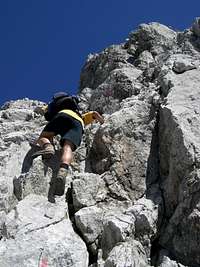 Climbing the summit block (05-08-2007) Climbing the summit block (05-08-2007) |  Kammerloch (05-08-2007) Kammerloch (05-08-2007) |
Traverse route from Ansbacher Hütte
This is an interesting alpine traverse in the heart of the Lechtal Alps.
Follow trail number 601 from Ansbacher Hütte in northwestern direction. At the first trail junction choose the left trail which leads up to Flarschjoch, a col between Samspitze and Stierköpfl. The trail descends to Knappenböden. Leave trail number 601 at the next trail junction, go straight on at the next (third) trail junction and start your ascent to Stierlahnzugjoch, the col between Vorderseespitze and Feuerspitze. Feuerspitze can be easily summited on a trail, starting below Stierlahnzugjoch (one hour roundtrip).
The trail traverses the west slopes of Feuerspitze between Stierlahnzugjoch and Lahnzugjöchl. Below Lahnzugöchl is the trail junction with the route from Kaisers. Traverse Lahnzugjöchl, descend into the northern cirque (easy rock scramble) to the starting point of the summit trail.
 Happy at the summit (05-08-2007)
Traverse Route from Kaiserjochhaus
Another interesting alpine traverse in the Lechtaler Alps. From Kaiserjochhaus follow trail number 601 to the east. Traverse the south slopes of Grießkopf (1,5 hours roundtrip from Kaiserjochhaus) and Kreuzkopf to Kridlonscharte.
At this col the trail changes on the noth side of the Lechtal main ridge, traversing the north slopes of Kridlonspitze, Aperriesspitze and Furglerspitze. All those peaks can be summited within 1,5 hours each from the trail.
Below Hinterseejöchl at a trail junction leave trail number 601 (which traverses Hinterseejöchl in the direction to Ansbacher Hütte) and go left, thus traversing the west slopes of Vorderseespitze. There are some ups and downs and there is a rock scrambling part with some fixed ropes, too (Klämmle).
After this intermezzo the trail traverses the west slopes below Stierlahnzugjoch and Feuerspitze. It reaches the trail junction with the route from Kaisers (see above) and ascends to Lahnzugjöchl.
Descend Lahnzugjöchl on its north side (some easy rock scramble involved. At the middle of the following cirque there is the trail junction with the summit trail which starts to the right.
Summit Route
Leave the trail number 636 below / north of Lahnzugjöchl and follow the marked trail which ascends steeply to Fallenbacher Joch east of the trail junction. The trail traverses the north slopes of Feuerspitze and reaches the south ridge of Holzgauer Wetterspitze at Fallenbacher Joch.
Follow the south ridge on the trail using mostly the west side of the ridge. The ridge (and the trail) ends at the huge summit block. The marked route leads up through a rock chimney (UIAA grade I) to the Kammerloch, a hole in the rockface with great views down Sulzeltal and Frederic Simms Hütte. The now exposed climb leads up a short, steep wall (UIAA grade II) to a traverse to the right. You reach much easier terrain by traversing a slab (fixed rope) and you gain the summit arete by ascending some scree filled ledges. The exposed but easy summit arete leads quickly to the summit with its marvellous views.
Accomodations
 At the summit block (05-08-2007)
The Lechtal villages offer all kinds of accomodations.
Informations about Lechtal are available here.
The villages of
Holzgau
Hägerau
Kaisers
near the trailheads are good places to stay several days.
The following alpine club mountain huts can be used as Stützpunkt for this hike
Edelweißhaus / Kaisers
Frederic-Simms-Hütte
Kaiserjochhaus
Ansbacher Hütte
Maps & Guide Books
 Feuerspitze, Vorderseespitze and Verwall glaciers seen from the summit (05-08-2007)
The best map is:
- Alpenvereinskarte 1 : 25.000, Blatt 3/3,
Lechtaler Alpen, Parseier Spitze
Alpenverein
The best guide book for hikes in Lechtaler Alps is
- Dieter Seibert
Alpenvereinsführer
Lechtaler Alpen alpin
Bergverlag Rudolf Rother, München,
ISBN 3-7633-1268-4
only available in German