
-
 5369 Hits
-
 82.48% Score
-
 15 Votes
|
|
Mountain/Rock |
|---|---|
|
|
47.27574°N / 10.48757°E |
|
|
Hiking, Mountaineering |
|
|
Summer, Fall |
|
|
7776 ft / 2370 m |
|
|
Overview
 Wannenspitze as seen from the north ridge (15-08-2009)
The Lechtal mountains are famous for their high trails, connecting the different mountain huts and allowing easy but impressive traverses through this wonderful mountain range. As you can easily guess you will not be alone in those regions.
But there exists a lonely and rather remote part of Lechtal mountains, too. These are the mountains which are standing high directly south of Lechtal valley: e.g. Lichtspitze, Ruitelspitzen, Griesspitze and: Wannenspitze
Around Wannenspitze there are no mountain club huts, there are no high trails and - as a consequence - there are no people.
You will get: narrow, steep and barely maintained trails, a quite strenuous day hike, pure nature, loneliness, a summit for your own with a nice view and the chance for a even nicer traverse to Karlespitze and Zwickspitzen. In short: a more than satisfying day full of adventure.
What you get not: water resupply ! Bring enough to drink !!!
Wannenspitze stands high south of the village of Häselgehr and is limited to the north by the Lechtal valley, to the east by Gramais valley and to the west by Griesbach valley. Häselgehr, Gramais and Griesau are the main trailheads for this mountain. To the south Wannenspitze is connected to the beautiful Schafkar region, west of the mountain village of Gramais, by a long ridge, which is used for the traverse to Karlespitze and Zwickspitzen.
Wannenspitze is an extraordinary place, when you sit high above Lechtal valley, overlooking most of Lechtal and Allgäu mountains, savouring the calm and silence of a beautiful summer day. Find it out some day.
Getting There
 Wannenspitze summit, crowded as always .... (15-08-2009)
The main trailheads for Wannenspitze are Gramais in the Gramaiser valley, Häselgehr or Griesau in the Lechtal valley.
You reach Lechtal valley
Follow Lechtal valley road number 198 from Reutte or from Lech / Warth until you reach Häselgehr or Griesau.
The trailhead is at the Häselgehr church on the orographic left side of Lech river.
At Griesau follow the road through the houses until you reach the chapel of Sankt Sebastian. There is a parking area.
The village of Gramais can be reached directly from Häselgehr by using the signposted mountain road up the Gramaiser valley. The trailhead is directly at the little village or behind a chapel some 500 meters before you reach the village. Parking space is very limited.
Red Tape
No red tape as far as I know.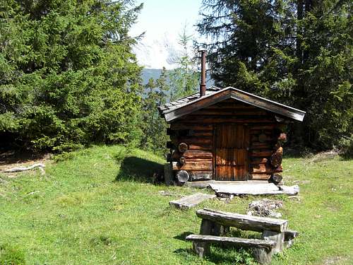 Beautiful log cabin at the Griesau ascent (15-08-2009)
Main Routes Overview
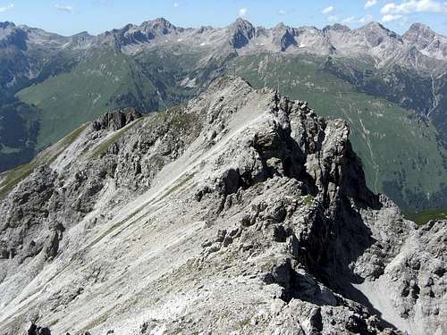
 Wannenspitze north / northeast ridge (15-08-2009)
Griesau / Häselgehr routes
From Griesau follow the signposts “Wannenspitze” up a forest road. After a long traverse a trail branches off to the right and reaches the Wannenspitze north ridge at “Auf der Lacke”.
From Häselgehr follow the trail up the Wannenspitze north ridge to Brünst, Hanselstadel and “Auf der Lacke”.
From there the route follows the north ridge to Muskogel, Hochwaldhütte (hunting log cabin) and Schnaggelplatz. At the end of the level ridge part below the summit block the trail climbs steeply up some easy rocks and circles round the summit block on its western side to gain the summit steeply from western directions.
From Griesau follow alternatively the forest road into Griesbach valley up to Griesbach Alpe, a nice mountain inn. There is a marked shortcut – a steep trail – wich cuts of the first switchback of the mountain road.
From Griesbach Alpe follow the forest road into the lower parts of Seebles Kar. At the end of the road ascent steeply the meadows amidst the forest on a small and partly marked path. This path sometimes disappears completely so orientation can be a real adventure. You must reach the meadow ridge west of Zwickspitze. On the ridge the path reappears (some red marks and some wooden signs) and traverses the west slopes of Zwickspitzen to Wieslesjoch.
From Wieslejoch follow the steep and marked path up the south ridge to Karlespitze and the short connecting ridge to Wannenspitze.
 Wannenspitze northern summit trail (15-08-2009)
Gramais Route
From Gramais follow the northern trail in the direction of Schafkar. Where it crosses the creek for the second time leave the trail and follow an old and narrow path up the valley in direction of Gampensattel.
At about 2000 m traverse to the north (right) over steep meadows up to Wieslesjoch between Karlespitze and Zwickspitzen. From Wieslejoch follow the steep and marked path up the south ridge to Karlespitze and the short connecting ridge to Wannenspitze. Difficult, partly off-trail route !
External Links
 Wannenspitze as seen from Karlespitze with Hornbach chain (15-08-2009)
In Lechtal valley there are all sorts of accomodations: Hotels, Inns, private Bed & Breakfast and Camping areas.
For general infomations please refer to: Lechtal tourist page
More detailed informations about accommodations in the nearest villages can be found on the homepages of
Gear & Mountain Conditions
Wannenspitze is a summer and autumn hike. As far as I know there are no winter and spring ski hike activities. It is a strenuous day hike from the valley trailheads or as one of several summits during the Wannenspitze – Karlespitze – Zwickspitzen traverse.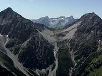 Summit view to Ruitelspitze and Holzgauer Wetterspitze (15-08-2009) Summit view to Ruitelspitze and Holzgauer Wetterspitze (15-08-2009) |  Summit view to Bretter- and Urbeleskarspitze (15-08-2009) Summit view to Bretter- and Urbeleskarspitze (15-08-2009) |
You need normal hiking gear with good shoes. There is some easy rock scramble near the summit and some exposed traverses on narrow and steep trails.
Check the current weather here.