
-
 3817 Hits
-
 79.78% Score
-
 11 Votes
|
|
Mountain/Rock |
|---|---|
|
|
47.26671°N / 10.49349°E |
|
|
Hiking, Mountaineering |
|
|
Summer, Fall |
|
|
7552 ft / 2302 m |
|
|
Overview
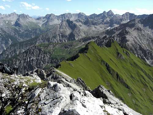 Zwickspitzen twins as seen from Karlespitze (15-08-2009)
The Lechtal mountains are full of geological surprises. The alpine tectonic has created very complex structures, synclines, anticlines and fault zones, and complicated thrust fault zones.
The twin peaks of Zwickspitzen belong to such a complex zone and even for a geologically not experienced mountaineer, those meadow summits amidst a rugged rock ridge are a very strange appearance.
Zwickspitzen are standing south of Häselgehr, a little village in the Lechtal valley. Limited to the east by Gramais valley and to the west by Griesbach valley, they are within the ridge, connecting Wannenspitze and Karlespitze to the Schafkar region west of Gramais.
Due to a zone of Malm- and Neokom-Aptychenschichten and cretazious sediments, rocks which easily decay to clay, Zwickspitzen build a green meadow interruption of the long rock ridge and a stark colour constrast.
But don´t underestimate those two peaks: they are not too easy to climb. Both have off-trail ascents with very steep meadows, which are absolutely not advisable when wet, and the southern peak has some very bad and loose rocks on the top.
It is good that Zwickspitzen are two remote peaks because there is only place for one person on the extremely narrow summit. So: no summits for a long summit break but two interesting peaks which can be pocketed while doing the traverse from Wannenspitze and Karlespitze.
Getting There
 Zwickspitze north and notch tower from south summit (15-08-2009)
The main trailheads for Zwickspitzen are Gramais in the Gramaiser valley, Häselgehr or Griesau in the Lechtal valley.
You reach Lechtal valley
Follow Lechtal valley road number 198 from Reutte or from Lech / Warth until you reach Häselgehr or Griesau.
The trailhead is at the Häselgehr church on the orographic left side of Lech river.
At Griesau follow the road through the houses until you reach the chapel of Sankt Sebastian. There is a parking area.
The village of Gramais can be reached directly from Häselgehr by using the signposted mountain road up the Gramaiser valley. The trailhead is directly at the little village or behind a chapel some 500 meters before you reach the village. Parking space is very limited.
Red Tape
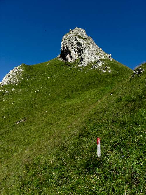
Nor red tape as far as I know. Whose peak is it ? (15-08-2009)
Main Routes Overview
 Zwickspitze south (15-08-2009)
Zwickspitze north can be climbed easily off-trail from Wieslesjoch by using the ridge line to the south.
To reach southern Zwickspitze follow the ridge line from Zwickspitze north to a col with a notch tower. Traverse the notch tower on steep meadows near its base on the west side and gain again the ridge line. Climb up the steep gras slopes to the base of the summit block of Zwickspitze south.
There is a direct chute up to the summit. The rock is very deteriorated and not good to climb. Better traverse the summit block at its base to the south and climb the southwest meadow ridge up to the summit.
Descent as ascent or descend carefully on the steep meadow slopes to the trail from Griesbach Alpe to Wieslesjoch.
The steep south ridge from Gampenjoch is more difficult (UIAA grade II) and you have instable and loose rocks; not adviseable !
For more detailed informations how to reach Wieslesjoch from Häselgehr, Griesau or Gramais please refer to the Main Routes section of the Karlespitze SP page.
 Zwickspitzen as seen from the Griesbach valley(15-08-2009) Zwickspitzen as seen from the Griesbach valley(15-08-2009) |  Zwickspitzen as seen from the north (15-08-2009) Zwickspitzen as seen from the north (15-08-2009) |
Accomodations
 Zwickspitze north (15-08-2009)
In Lechtal valley there are all sorts of accomodations: Hotels, Inns, private Bed & Breakfast and Camping areas.
For general infomations please refer to: Lechtal tourist page
More detailed informations about accommodations in the nearest villages can be found on the homepages of
Gear & Mountain Conditions
 Zwickspitze south and the trail to Wieselesjoch (15-08-2009)
Zwickspitzen are a summer and autumn hike. As far as I know there are no winter and spring ski hike activities. It is a strenuous day hike from the valley trailheads or as one of several summits during the Wannenspitze – Karlespitze – Zwickspitzen traverse.
You need normal hiking gear with good shoes. Zwickspitzen require a short but very steep off-trail ascent on steep meadows with some rock scramble in loose and crumbled rocks. Not to be summited during wet periods; those meadows can be very dangerous, then !
Check the current weather here.