
|
|
Mountain/Rock |
|---|---|
|
|
42.74601°N / 0.26711°E |
|
|
Hiking, Mountaineering, Mixed, Scrambling, Skiing |
|
|
Spring, Summer, Fall |
|
|
9642 ft / 2939 m |
|
|
Overview
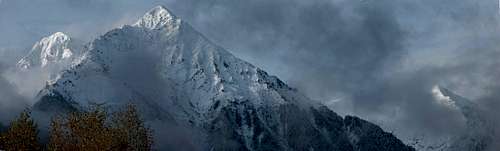
 North face
 From Lustou
 North face
 From Cap de Laubère
 North face
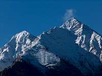 North face
 A volcano ? :)
 At sunrise At sunrise |
Pic d'Aret is a quite paradoxal peak. While its impressive northern face, doubled with its twin the Pic de Tramezaïgues, belongs to the lanscape of the Vallée d'Aure (not to say the emblematic view over Saint Lary), as well as its huge height, close to 3000 meters, this peak is almost never climbed.
 North panorama North panorama |
The peak is not difficult to climb... It's a mountain for walkers. But the real reason is that there is no less than 2000m to climb up, with 3/4 of them making a monotonous climb into an uniform deep valley, which doesn't allow any panorama from the start to the end... not a generous mountain this Pic d'Aret !
But the summit panorama is not less rewarding, allowing original and unusual views to the famous neighbours, in the Néouvielle and Lustou regions.
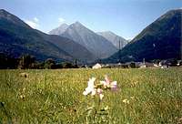
 The Aret closes the view at the end of the Saint Lary valley The Aret closes the view at the end of the Saint Lary valley |
Getting There
 Valley view
 North face
 Valley view
 North face
 From Rioumajou
 From ">Ourdissetou
It is possible to start the walk either at the village of Tramezaïgues, the longest option, but the only one which diversifies a bit the walk, or get as high as possible using a track turning sharp right near the entrance of the Rioumajou valley.
This way, we gain about 200m of height, but at the price of a longer approach by car on a land-rover track. We also skip the beautiful farms and castle ruins over the village...
View Larger Map
 The top from Pic de Sarroues
Route
 Tramezaïgues castle
 Tramezaïgues barns
 The long the way up
 The long the way up
 The long the way up
 To the summit
 To the summit
 SE view from the top
 Aure valley
 from Péguère's Ravine
 The long way up The long way up |
There is ony one route, which climbs into the long corridor valley located north from the Sarroues, along the stream Rau de Lassas.
One place in the middle of the ascent, "pas de Sarroues", requires just a bit of attention, but hands are not needed.
We climb like this until the so-called "Lac de Sarroues", a laked which is empty most of the year, difficult to guess; rather a marsh. Best place to bivouac near the top of the mountain since flat.
The rest of the ascent consists in elevating in the screes of the summit, then on the east ridge.
 South view from the top of Pic d'Aret South view from the top of Pic d'Aret |
On the top, we realize that what we thought to be the top from Saint Lary is not indeed the real one, but slightly behind. To appreciate the full view to the valley and be at the top of the pyramid as seen from downside, one must climb down slightly to reach the point 2883m.
It is also possible to reach the secon twin top, Pic de Tramezaïgues (2572), but the ridge between them is said to be made of loose stone, slippy when wet, and very exposed. The way down from Pic de Tramezaïgues to the starting point is also quite adventurous, via a steep slope in the forest, until we reach the clearing Plo de la Coume, and a path that brings us back to the track from Rioumajou.
The website of Philippe Queinnec has an excellent map of these trails.
 From Port d'Ourdissetou, in the distance From Port d'Ourdissetou, in the distance |
Blue tape
 Over the Neste d'Aure
 Over the Neste d'Aure
 Panorama to the Néouvielle région Panorama to the Néouvielle région |
No regulations, as Pic d'Aret does not lie in any park.
The circuit visiting the Pic de Tramezaïgues must absolutely be made by dry weather.
Many accomodations and campsites in the Aure valley :
http://www.vallee-aure.com/
No known open sherperd hut in the surroundings...
Wildcamping possible, and very nice location at the lakes of Consaterre.
Accomodation
 Night view
 River view
Many accomodations and campsites in the Aure valley :
http://www.vallee-aure.com/
Let's mention a house for rent in Tramezaïgues
No hut at all in the surroundings. As mentioned above, a good bivouac place near lake de Sarroues.
One accommodation is worth mention for large groups of people: La Filature (former spinning mill), in Ancizan, with further information here and here (French). Prices can go as low as 10€ for groups over 10 people. A separate apartment is available too but rates may vary depending on the charges being shared with others or not.
 The Pic d'Aret over Saint Lary valley The Pic d'Aret over Saint Lary valley |