Overview
Mount Whitney is the highest summit in the contiguous United States with an elevation of 14,505 feet (4,421 m). It is located at the boundary between California's Inyo and Tulare counties. The western slope of the mountain lies within Sequoia National Park and the summit is the southern terminus of the John Muir Trail, which runs 211.9 miles (341.0 km) from Happy Isles in Yosemite Valley. The steep eastern side of the mountain offers a variety of climbing challenges. The "Mountaineer's Route", a gully on the north side of the east face first climbed by John Muir, is considered a scramble.
After successfully reaching the summit via the MOUNTAINEER'S ROUTE in the September of 2007, this posting is for others thinking about climbing this route for the first time.
Getting There
The best thing about this route is you don't have to be part of the regular Whitney trail lottery system. Although, you will have to aggressively go after the permits and be flexible on the dates. For instance, I originally wanted to go at the end of August, which is supposed to be the best time to climb the MOUNTAINEER'S ROUTE in the summer; however, I had to go with a weekend date in mid-September instead. Also, they give out a very limited number of permits per day so you'll have to keep your group size to about 4 or less. This route starts at the regular Whitney Portal location, but if you plan to camp out at Whiney Portal the night before the hike (like we did) then I highly suggest making campground reservation at Whitney Portal. The backpacker's campsite is very small and fills up very quickly. Also, the backpacker's camp has very limited bear box space and it is almost certain to be packed full when you arrive. If you reserve a campsite, you'll get your own fireplace and bear box, etc…
Route Description
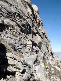
Contrary to what I had read, the MOUNTAINEER'S ROUTE is a trailed route, at least it is trailed until you reach UPPER Boy Scout Lake. However, since this route is not maintained you may go the wrong way a few times, in which case you soon realize because there's no where else to go. For this reason, I would suggest staying together as a group. After you reach UPPER Boy Scout Lake there will no longer be a trial, but it is easy enough to find your way since you can only go up (or back the way you came). Also, I highly recommend setting up your base camp at LOWER Boy Scout Lake, as opposed to staying at UPPER Boy Scout Lake. The LOWER lake has an easily accessible water supply, it is less windy and cold and it sits a little lower in altitude so you are almost certainly able to get a good nights sleep.
After Iceberg Lake the MOUNTAINEER'S ROUTE becomes extremely strenuous (since it is at altitude). Also, I found the rock scramble to be easy with only two exposed (dangerous) sections that can be overcome with a little planning. If you have never climbed I would highly recommend taking a class at a local climbing gym, as you will feel much more confidant on the mountain. Also, if you are worried about the two small exposed sections located on this route (which makes it a class 3, but just in this small section of the climb), just bring a 30-feet rope for protection and sling it around some rocks for an anchor. Nothing expensive and professional, just something that will hold your weight in an unlikely event of a fall. It's really just an emergency utility rope to be used without a harness. I also used the rope for my cousin (who's not a very good climber) on a section at the LEDGES during the first day of the hike. You can get more information about the LEDGES section from Doug Thompson's book on Mt. Whitney (see below).
![David & Doug]()
For more information about the MOUNTAINEER'S ROUTE, including pictures and detailed route instructions, I recommended picking up a copy of Mount Whitney: Mountain Lore from the Whitney Store by Doug Thompson. This is the best book available regarding this route. Also, stop in to the Whitney Store before heading up and you may even see Doug Thompson there. He'll even give you more information about the current conditions of the trail if you ask him and answer any other questions that you have.
I hope this information helps. Good Luck!!
Essential Gear
-Sleeping Bag (for 30-degrees or better)
-Warm Layers for the summit
-Helmet (optional)
-Rope / 20ft (optional)


Comments
Post a Comment