
-
 11692 Hits
-
 85.87% Score
-
 21 Votes
|
|
Mountain/Rock |
|---|---|
|
|
36.16524°N / 115.43255°W |
|
|
Scrambling |
|
|
Spring, Fall, Winter |
|
|
4987 ft / 1520 m |
|
|

Overview
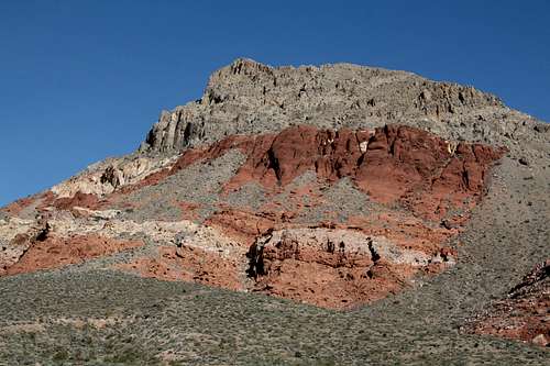
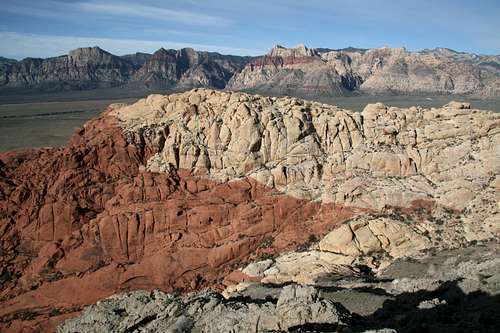
New Peak is one of several minor summits in the Calico Basin section of the Red Rocks area that offer short but enjoyable scrambling routes and excellent views of desert peaks and canyons. Calico Basin is just east of the beautifully colorful Calico Hills and can be used as an alternative approach to them if one wants to avoid paying the fee for the Scenic Drive in Red Rock Canyon National Conservation Area, which is the means of access most visitors to the Calico Hills use. Another drawback to the Scenic Drive and thus advantage in using Calico Basin is that the Scenic Drive is one-way only and the Calico Hills are accessed from points one to three miles in, meaning anyone who wants just to visit the Calico Hills must drive the entire loop road, where traffic can be infuriatingly slow on busy days.
On maps, New Peak is Point 4987, which is northwest from the end of Sandstone Drive, where the parking area for Calico Basin is. Much of Calico Basin is private property, but a few locations accessible to the public do provide legal access to the mountains and canyons there. Always respect any posted property boundaries, though, lest landowners grow irritated and begin agitating for closure of these access points, something that happens all too often where private land abuts wilderness-quality public land.
New Peak is in the La Madre Mountain Wilderness Area. The name is an unofficial one but is not my own; my source for the name is the guidebook Rambles & Scrambles: The Definitive Guide to Peakbagging Around Las Vegas by SP member cp0915; this book is a wealth of information on peaks within a day's drive of the Las Vegas area and has an extensive collection of route descriptions for peaks in Red Rock Canyon National Conservation Area. From the guidebook, I also learned that the mountain is also known as El Hijo, Spanish for “the son.” Unfortunately, that book is now out of print.
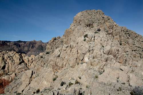
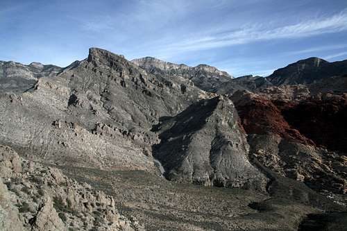
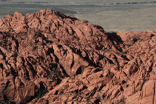
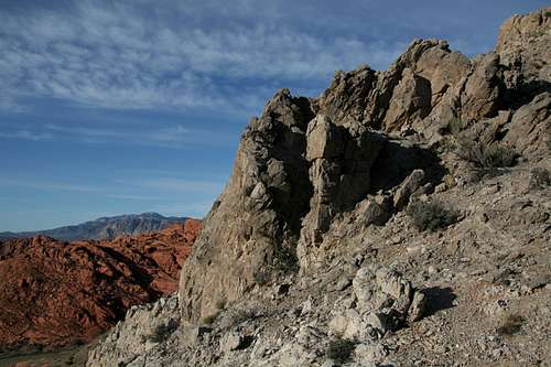
The views from New Peak's summit are exceptional. One standout is Turtlehead Peak. Even better is the view across the red and yellow tops of the Calico Hills to the big, famous Zion-like peaks of the Red Rocks area. The standard route up the mountain is mostly a hike, but there is a fun Class 3 section near the summit that helps make the steep slog up loose rocks and dirt to get there worth it.
This peak is nothing to brag about over beers in the evening, but it makes a great short objective if time is limited. During my April 2009 visit to Las Vegas with my 4-year-old son, I was looking for high-quality things to do early in the morning before my son woke up (we were staying with my brothers, so I wasn’t leaving him unattended) or with my son later in the day. Some other SP members recommended this and other peaks; their recommendations were spot-on.
Routes
East Ridge
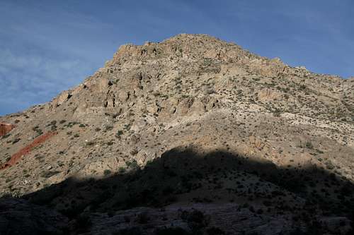
This is the "standard" route. From the parking area, hike north along a trail until you meet a wider trail paralleling the south side of Kraft Mountain. Hike west until you reach a trail heading north to a pass between Kraft Mountain and New Peak. Hike to the pass, which is at about 4300’, and then head west up the ridge to the summit. For the last couple hundred or so vertical feet, you'll enjoy (or you should) a rugged Class 3 section. Exposure is not really an issue; ironically, exposure is only going to be an issue if you try to bypass the Class 3 section along its south edge (Class 2 on loose and somewhat exposed terrain).
One-way distance to the summit is 1-1.5 miles, with about 1300' of elevation gain (TH elevation is approximately 3700').
East Ridge Variation
The guidebook suggests leaving the trail before the pass and heading up via the orange and red sandstone formations on the south face of the mountain. This can be anywhere from Class 2-4+.
New and Kraft Together
Consider climbing this peak with the peak to its immediate east, Kraft Mountain; this will give you the option of two different routes on Kraft plus climbing a second peak during your outing, and the total distance can still be under three miles.
Views
Getting There
From Charleston Boulevard (Route 159) west of I-215 and Summerlin, turn onto the signed road to Calico Basin; this road is about one mile east of the entrance to the Scenic Drive in RRCNCA. Keep right when you reach the spur to Red Springs Picnic Area and soon bear left onto Sandstone Drive. Follow that road to its end; there is a large and obvious parking area on the left. The distance from 159 to the parking area is about two miles.
Red Tape
There are no fees for Calico Basin, but please respect property boundaries and posted wilderness regulations.
This area is unpleasantly and dangerously hot on most summer days. Climb here very early in the morning or at night if at all.
Camping
There are no campgrounds in Calico Basin. The area is best-suited for day hiking and climbing, anyway.
External Link
BLM site for RRCNCA