
-
 9602 Hits
-
 76.66% Score
-
 7 Votes
|
|
Mountain/Rock |
|---|---|
|
|
39.73397°N / 106.31305°W |
|
|
Summit |
|
|
Mountaineering |
|
|
Spring, Summer, Fall |
|
|
12922 ft / 3939 m |
|
|
Overview
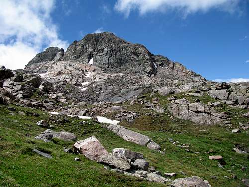
Looking for lots of piece and quietness - Peak I deep in the Gores has plenty of it. Not sure if it would win the title of "Most obscure summit of the Gores Alphabet", but it is sure a very good contender.Unlike the other "Alphabet Peaks" it is neither located on the main spine of the Gores nor is is directly connected to the spine via a ridge. Peak I even likes solitude from its own siblings. It is separated by a wide and deep saddle from the Ripsaw Ridge and stands as a silent guardian high above the valley of a South Black Creek.
Getting There/Route


Peak I can be accessed from the East and the West side of the Gore Range.
Piney Lake Trailhead:
Get off at Exit 176 on I 70 - go west and turn on Redsandstone Rd, which turns into Piney Lake Road. Most of it is dirt road, can be a bumpy ride, but doable for a normal sedan - just take it slow. Park outside the reserve gate to your right.
Route options:
OPTION 1: via Kneeknocker Pass:
Walk on the trail along Piney River to the Falls, and turn soon after the falls on a trail up to Kneeknocker Pass. Cross pass and climb down on the east (snowfield may last deep into the summer or may not melt off at all - depending on snowfall in prior winter) until you are right below the pyramidshaped mountain (Dwarf Pyramid) to your left. Hike up a small valley to your right until you reach Bubble Lake. The aptly named mountain "The Elephant" is rising on the other side of the lake. A small creek is running parallel to the "trunk" of The Elephant - follow the creek until the notch to the right of the main summit - the summit rising on the other side of the valley below the notch is Peak I
OPTION 2: via Peak H: Walk on the Piney River Trail until you are right below the North Face of the Spider. The mountain to your left is Peak H. Hike up the grassy slopes to the notch right next to Peak H - it offers the only access to the Black Creek Draynage (the ridge connecting Peak H with Peak J is dropping off otherwise more than 300 ft vertically to the Eastern Side).From the notch a steep snowfield is leading down to the valley below Peak I.The most upper part of the snowfield will melt out most the times mid June, which turns it into a very steep, rubble filled gully. At the bottom of the snowfield, you will see Peak I to your left.
Brush Creek Trailhead:
From Silverthorne, drive north on Hwy 9 16 miles and turn left on the Heeney Creek Road (CR 30.).
With 2WD: park at the Kansas Gulch-Grandview Cemetery - 0.7 miles to the right after turn off. Don't miss the marker with the interesting (and tragic) history of the first settlers in this area.
With 4WD: turn sharp left 0.6 miles after turn off onto FS 1695. The first half mile is a steep, rocky and narrow dirt road with only enough space for one car. Meeting a a car on one of the steep ascents may put you into a tricky spot. Any rain will turn the road into a slippery mess. The road relents after the initial climb but there are still several deep ruts to be mastered until you reach the Brush Creek Trailhead.
Notice: FS 1696 is closed for vehicle traffic between Nov 20th and June 23rd - the gate right at the beginning of the forest road will be locked.
The hike from CR 30 up to the Brush Creek Trailhead takes less than an hour (should you gauge benefit of driving up there vs risk of damage to your car).
From Brush Creek TH hike to the junction with Gore Range Trail. Turn right (Northwest) on Gore Range Trail until reaching the junction with Lost Creek Trail. Turn left (Southwest) onto Lost Creek Trail.
About half way to Lost Lake you will enter a patch of dead pine trees. The most Southern part of the patch forms a flat and narrow pass between the Brush Creek and Black Creek Drainage (right South of Point 9795). One can see Dora Mountain through the trees on the other side of the Black Creek Valley.
Leave the trail to your right (West) and hike the 60 ft or so to the steep drop off down to the Black Valley. The tricky part is that (status 2019) there is no trail whatsoever indicating where to turn off from Lost Creek Trail - it's just brush and fallen trees. When reaching the drop off look around a bit and (almost) miraculously a well built 2 ft wide trail starts right at the edge of the drop off and leads into the Black Creek Drainage. This trail is not marked on any map.
The trail skirts almost level around the North side of Guyselman Mountain and switchbacks eventually up into the South Black Creek Valley. Ironically this long forgotten route must be the best built trail in the entire Gore Range. A lot of man power must have been used decades ago to dig it into the mountain side and shore it up with stone walls. Expect to climb over and under many fallen trees
The trail will eventually drop you off in a large meadow along the South Black Creek.
There is no established trail leading from the first meadow higher up into the South Black Creek Valley. You have to do with faint climbers/animals tracks. These are not easy to follow in early summer and fall, and bascially impossible in high summer. You probably just end up bushwhacking your way up and down the valley - meaning slogging thru swamps, climbing over an endless number of fallen trees, drudging thru creeks all while making your way through shoulder high vegetation in high summer. While being eaten alive by moscitos.
SUMMIT CLIMB:
Peak I is rising only 300 - 500 ft from the surrounding valleys - its bomberproof rock provides numerous scrambling routes (Class 3 -5) to the top.
Mountain Condition /Equipment


This is a very remote area. Do not count on anyone coming by for a long time. If anything happens you are on your own.
Black Creek is prime black bear habitat - make sure you store your food properly
Red Tape

You will enter a pristine area - tread lightly and leave no trace - please build no fire rinks in such a wild area.You will hike most of the time in the Eagle's Nest Wilderness Area - please abide to all rules and regulationsEagles Nest Wilderness Regulations
Camping
The Black Creek Draynage is all yours when you reach it - you are most likely the only one there. Plenty of space for a camp or a bivouc.