
|
|
Area/Range |
|---|---|
|
|
36.48800°N / 121.1961°W |
|
|
Hiking, Trad Climbing, Sport Climbing, Toprope, Bouldering, Scrambling |
|
|
Spring, Fall, Winter |
|
|
2720 ft / 829 m |
|
|
Overview
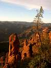
Commonly called the Pinnacles, these rocks are eroded remnants of an ancient volcano, featuring hundreds of rounded spires with grainy surfaces. On these rocks are tons of short technical rock climbing routes (single to a few pitches) popular for sport climbing, on weak, brittle volcanic breccia.The Pinnacles are located in Gabilan Range, the middle of the three parallel Coast Ranges along the Pacific Coast south of San Francisco. The area is protected as the Pinnacles National Park. San Andreas Fault, the major source of California earthquakes, is located a few miles to the east along San Benito Valley.
Climbing areas in Pinnacles National Park are primarily in the following locations: Bear Gulch, High Peaks, the Balconies, the Fingers, Machete Ridge. Additionally Bear Gulch and the Balconies areas contain caves (see comment by keema). Located in the High Peaks area is also the high point of the Pinnacles: Hawkins Peak, also known as "Tuff Dome".
More than just a rock climbing park, the Pinnacles is a favorite hangout for raptors, cliff-nesting birds and other wildlife. The rocks offer endless hidden nooks for scrambling and exploration. They remind me of fairytale landscapes full of wonder and surprises. One of the amazing places is the steep, sometimes 1 foot wide High Peaks trail built on the edge of cliffs with footsteps chiseled into solid rock.
 |  |  |  |  |
Getting There
Pinnacles National Park has two entrances: east (Bear Gulch) and west (Chaparral). There is no road connecting the two. The east entrance leads to most visitor facilities. The Pinnacles are about 2.5 hours south of San Francisco.Directions to East Entrance: Take Hwy 25 southbound off US-101 highway to a few miles south of Paicines, turn right (west) on Bear Valley Road. Proceed to the end.
If you come from southern California, take US-101 to King City, then take Bitterwater Road towards northeast for 17 miles until it joins Hwy 25. Turn left (north), then after a few miles turn left again (west) on Bear Valley Road.
It is also possible to take Interstate 5 from southern California to Coalinga, then take back roads for about 60 miles to connect to Hwy 25. Proceed further north to Bear Valley Road.
Directions to West Entrance: Take US-101 highway to Soledad, then take Metz road south for a few miles, turn left (east) on Shirttail Canyon Road and proceed to the end.
 |  |  |  |  |
Red Tape
There is a $5 parking fee good for 7 days.East side entrance is open 24 hours a day. West side entrance is open daily 7:30am - 6pm in winter and 7:30am - 8pm in summer. No sleeping (camping or in car) is allowed anywhere within the National Park but overnight hiking is permitted. If you drive in from the west side, your car will not be ticketed if you return after gate closure.
Some rocks are banned from climbing during the nesting season of raptors (January to July). There are also other regulations regarding use of bolts, chalk, webbing color, etc. Find all regulations at the official website.
When To Climb
Spring and Fall are best times to visit the Pinnacles. Summers are extremely hot, with day time high temperature of up to 110 degrees Fahrenheit (43 Celsius). Winter rains may loosens the climbing holds.Camping
There is a campground right outside the east entrance run by the National Park Service. Commercial lodging can be found at nearby towns such as Hollister, Salinas, or King City.Mountain Conditions
Find out the current weather at the NOAA Weather Station located here , fairly close to Bear Gulch Visitor Center (link contributed by mpbro).External Links
- Clint Cummins's page
An exhaustive, lovingly-maintained Pinnacles climbing site.
- NPS Raptor closure page
Excellent page with closure areas illustrated by hand-drawn maps. The specific rocks declared off-limits changes from year to year and within a given year, depending on the nesting situation. For the most recent updates, check the ranger station or the notices posted at the trailhead.
- Morgan & Kim's May, 2002 Pinnacles climbing trip
- Pinnacles Campground
Your only camping option within close range of the eastern entrance. $7/night, reservations taken.
- Friends of Pinnacles
Excellent website, overlapping both Cummins' and the NPS' pages in breadth. Useful to check here for redundancy in climbing beta/red tape updates.
- A cross-country scramble - Mar 17, 2001
- Pinnacles National Park
The home page for the Park
mpbro - May 24, 2002 3:22 pm - Voted 10/10
Untitled CommentThe Raptor closures generally only affect climbs in the High Peaks area, but be sure to check the NPS page before your trip. Updates to the page are sporadic. Sometimes certain climbs will open in the course of a year. The Bear Gulch trailhead (one at the very end of the road) had climbing closures posted. The rangers can also provide updated info.
mpbro - May 24, 2002 3:30 pm - Voted 10/10
Untitled CommentUnfortunately, Pinnacles NM permits day use only. No backpacking, and no hiking in the dark. As mentioned on NPS page, "summer hours" are 07:30-21:00. On both the eastern and western entrances, gates are locked. Getting caught behind a locked gate will earn you the ire of the ranger who has to stay behind to unlock it, as well as a pricy ticket.
Special note: I, "mpbro", was able to enter the park (east side) on two successive weekend days, well before the 07:30 opening time. Regarding the de facto opening time, snwburd notes, "I think it's pretty much up to when the ranger decides to get to work in the morning. Last time I was there, I was too early (didn't know they had a curfew) and had to hang out for the ranger to show up. That morning he was 1/2 hour late, offered no explanation, apology, or even a greeting, as I recall." In the summer, an extra hour in the morning can make the climbing day longer and more enjoyable.
mpbro - May 24, 2002 3:43 pm - Voted 10/10
Untitled CommentThe highpoint within the park is North Chalone Peak (3304 ft.), although this rounded, parched mass is hardly indicative of the geology that makes Pinnacles famous. Hawkins Peak, a.k.a. "Tuff Dome", is effectively the highpoint (2720 ft.) for climbers, since it is situated in the center of the High Peaks area and offers a variety of technical routes to the summit.
keema - Dec 22, 2002 6:34 pm - Voted 10/10
Untitled CommentI went to Pinnacles today. The ranger said the Bear Gulch caves have been closed for the past several years due to a bat study. He said the study is complete and that there should be several slots during the year when the cave will be open. Check the Monuments web page or call for open times.
tarol - Jan 12, 2006 4:19 pm - Voted 10/10
Untitled CommentWhen I visited Pinnacles National Monument a couple of years ago I had a couple of run ins with wild pigs. First of all, do not choose a campsite underneath an oak tree at the campground just outside the park. Pigs love acorns and I was awoken many times during the night to have a bunch of very noisy pigs rooting around my tent.
Second of all, if you hike by yourself, be careful. I was charged by a very large boar and it scared the crap out of me! I've heard carrying an air horn and blaring it should you be charged is an effective defense.
According to this website, they hopefully have the fence around the park up and most of the pigs gone by now...
http://www.nps.gov/pinn/pphtml/6highlights379.html
lisae - Jan 2, 2010 10:21 pm - Voted 10/10
Campground and West Side GateThe campground is no longer privately owned - the National Park Service bought it and runs it. Camping is $23/night. Also, while the West Side is gated, they no longer ticket you if you leave after closure, which allows for late hiking and climbing. No more hurrying back to the car! I think both changes have been in place for several years.
gordonye - Jan 7, 2010 4:35 pm - Hasn't voted
Re: Campground and West Side GateThanks, this is great info!