
-
 18129 Hits
-
 74.01% Score
-
 4 Votes
|
|
Route |
|---|---|
|
|
36.49693°N / 121.20138°W |
|
|
Trad Climbing, Scrambling |
|
|
Fall, Winter |
|
|
Most of a day |
|
|
5.3 (YDS) |
|
|
6 |
|
|
II |
|
|
Overview
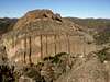
Machete Ridge is a spectacular wall located at the western end of Pinnacles, directly across from the equally spectacular Balconies, just a few minutes walk from the Chaparral Campground and picnic area. The formation is host to over two dozen routes ranging in difficulty from 5.2 to 5.12, including some of the longest routes in the monument. Of these, perhaps the most popular is a traverse of the ridge from south to north. Named "Old Original" and rated only 5.3, this is described--accurately--in the Pinnacles guidebook as "an absolute must for those seeking an easy day-long adventure."The route is less of a rock climb than it is a combo hike-scramble-rock climb-bushwhack-gully descent outing, and more time is spent descending than actually going upwards. We encountered no more than perhaps 20 feet of 5th class all day, well protected on good rock, but did some seven rappels in all--one of them free, and another that was 160ft long. Varied, easy, scenic, and good fun.
 |  |
Approach
Follow the directions on the main page to the Chaparral campground, located at the end of the western segment of SR 146, 13 miles east of Soledad. Follow the Balconies trail for about 1/2 mile to a signposted fork at a small footbridge over the stream, with the left fork leading up to the Balconies Cliffs and the right fork heading down to the Balconies Caves. A signed climber's trail (saying "Machete Ridge access") heads off to the east just before this bridge.Follow this trail steeply up and along the base of Machete Ridge, around its south side, and along the base of the east face. Continue up to a small saddle between Machete Ridge and some large boulders to the east. (To help identify it, two pine trees are found at this notch). From the notch, scramble left up to a large ledge with a pine tree at its north end (GPS coordinates: 36.49693° N, -121.20138° W, NAD83 / WGS84 Datum).
Route Description
Pitch 1 (5.3): Belay from the pine tree at the north end of the ledge. The route heads left and up past a small bush to a bolt, then zigzags right to a two-bolt anchor. You may as well belay and unrope here; it's a walk from here to the third pitch.Pitch 2 (walk): Continue up to the ridge crest (there should be a bolt here, although I don't remember seeing it), and walk north along the airy but easy ridge to a small notch with two bolts.
Pitch 3 (5.3): Traverse down and right around a bulge (5.3 crux, protected with a bolt), and continue to another bolt. The climber's guide recommends continuing and belaying from a manzanita bush further along the ridge, but you may as well stop and unrope here; the next couple of hundred feet of the ridge are a walk/easy scramble.
Pitch 4 (walk): From that last bolt, continue 40 ft to a flat area, and scramble up through a small notch past some manzanita bushes. Continue walking north along the ridge, passing a bolt en route, to a three bolt rappel station.
Pitch 5 (rappel): Rappel(s) to the northwest, to the ridge below. With two 50m ropes, it's reportedly possible to make a single rappel to the ridge. Alternatively, there are two intermediate rap stations (each two bolts) to allow a rappel with a single 50m rope. The first two are low angle and could be downclimbed as class 3 or 4; the final rappel is free for the last 20 feet or so.
Pitch 6 (class 4 or rappel): At the base of the previous rappel(s), walk over a small bump to a U-shaped notch between two small towers. Scramble up to the notch (class 3, although the climber's guide inexplicably calls this 5.3), where you'll find a bolt. Either downclimb the lichen-covered class 4 rock on the other side, or rap down. Continue a short way to the base of the next tower along the ridge (the Middle Tower), where you'll find a block with bolts on both sides. This marks the end of the usual route, although if you have time, it's possible to continue up the Middle Tower (5.5).
 |  |
Descent
The descent off the ridge shouldn't be taken lightly--it's arguably more challenging than the actual ridge traverse! From the aforementioned bolts, rappel 80ft to the gully to the east. A vague use trail, and sometimes wet, mossy class 3 rock leads down the gully to several trees and established rappel anchors. It's possible to continue downclimbing sketchy, mossy rock, but it's probably more pleasant--not to mention safer--to just rap down from the trees to a grassy area. The usual descent route presumably continues along still more of the treacherous, exposed slabs and slippery grass ledges to weave its way down through poison oak thickets. A more enjoyable (and poison oak-free) option is offered by a 160ft rappel from a sturdy tree here, to the Balconies Caves down below. At the base of the rappel, follow a use trail down into the caves, and weave your way down through the talus to the trail.Essential Gear
A 50m rope would suffice for the rappels, but it is best to carry two such ropes to expedite the descent (and more importantly, avoid the poison oak). The short technical portions are easy and adequately protected by bolts, with few/no opportunities for other protection--a couple of slings and quickdraws suffice.Links and Further Information
Rubine's "Climber's Guide to Pinnacles National Monument" contains an excellent map and description of the route.Trip report, including photos (June 2002).
Another trip report (May 2001).