


-
 824 Hits
-
 80.49% Score
-
 12 Votes
|
|
Mountain/Rock |
|---|---|
|
|
45.79320°N / 7.37456°E |
|
|
Aosta Valley, Quart-Valpelline Municipalities |
|
|
Hiking, Mountaineering |
|
|
Spring, Summer, Fall, Winter |
|
|
9035 ft / 2754 m |
|
|
Note
|
La montagna chiama i suoi figli, ed essi rispondono fedelmente al suo appello… Osvaldo Cardellina, Diario alpinistico, 1964-65 Page texts: @ OsvaldoCardellina "Osva", passed away on May 2, 2022. Page owners: Christian Cardellina e Osvaldo Cardellina. Any updates from September 12, 2022: Antonio Giani, page administrator, friend and climbing companion. Testi della pagina: @ OsvaldoCardellina "Osva", scomparso il 2 maggio 2022. Proprietari pagina: Christian Cardellina e Osvaldo Cardellina. Eventuali aggiornamenti dal 12 settembre 2022: Antonio Giani, amministratore della pagina, amico e compagno di salite. |
Overview
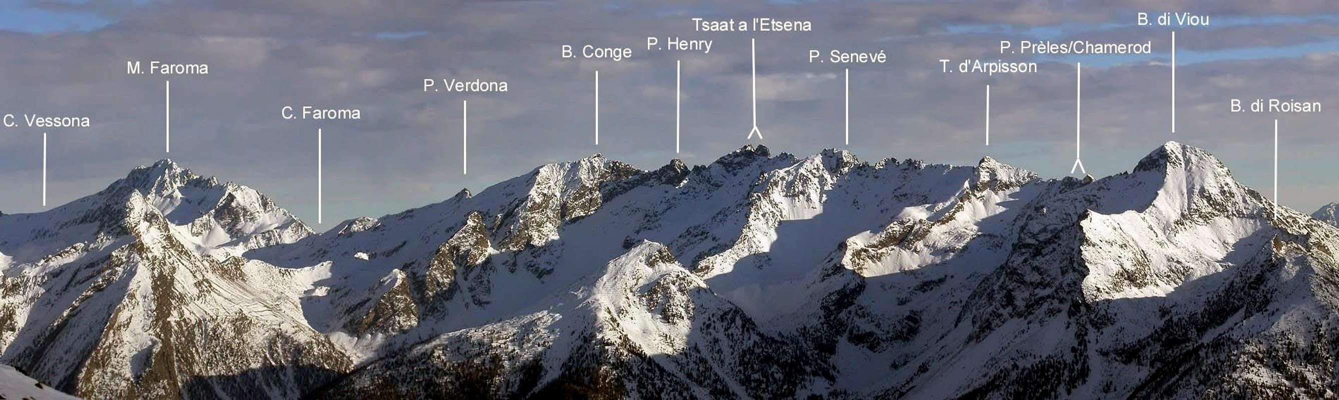
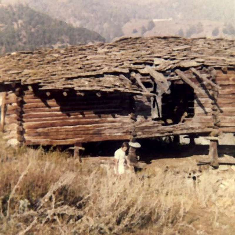
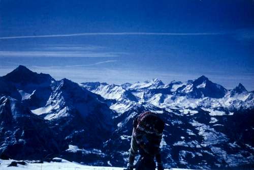
The Pointe or Punta di/de Chamerod (about 2.752/54 meters)that takes its name from the underlying locality , with a little village formed by some renovated buildings enough recently, was up to the early seventies consisting of old rascards or wooden and stone buildings suspended by some small pillars on a stone base, as per informations from a local shepherd in the summer of 1971. It constitutes a small Summit, almost "timid" because it is half hidden behind the rugged and more robust Mont Mary (2.815 meters) , which "invades" both the Conca di Blavy (to the West) and the Basin of Senevé or Cénevé (to the Southeast). Moreover it forms a small peak not quoted nor named on any paper, manuals or mountain books and no. It is the natural extension of the Northeast Crest of Mont Mary, forming almost a pivot, exactly at the point where it bends decidedly towards the East reaching a a consecutive series (precisely three) of small elevations. Instead on the Northwest side it falls with a short (about 140/50 meters), yellowish and almost vertical wall on the underlying Lago di Arpisson into the Arpisson Valley in Valpelline. Ascended, perhaps for the first time, by Osvaldo Cardellina and Marco Périer on March 30th, 1969 in crossing from Becca di Viou and back to it and also traveled even in the middle of winter on February 23, 1975 by Osvaldo Cardellina, Marco Cossard and Giuseppe Lamazzi in an ascent without skis or even snowshoes, starting from the Village of Blavy (1.475m) and crossing on the ridge towards Mont Mary and Punta di Chamerod, identical return and extension to Becca di Viou (2.856 meters), main or better known Summit of this little mountain area above the Municopalities of Roisan, Aosta, Saint Christophe and Quart. To follow the Chamerod Southwestern Carving (about 2.740/2 meters); it takes its name from the neighboring point as well as the homonymous point, resulting like in a small breach between it and the more Les Prèles Western Point (about 2.750/52 meters) . Even this last and adjacent Summit results of easy to access from the South enough wide face, it has a decisively difficult slope in North side, in practice twin and parallel to that of the adjoining Punta di Chamerod with which it joins at the bottom but less than two thirds high and to a lesser extent when viewed from the Northwest, for which transit is not recommended and certainly not easy, as it develops in a small wall of about 150 meters wedged between the two rocky ribs coming from the homonymous point and from that Pointe of Les Prèles; it is made up of broken rocks and quite steep and very exposed to falling stones. All these small Summits can be visited, starting from the Village of Chamerod or from the main Fraction of Trois Villes starting at the Hamlet of Avisod, in a single day in which it is also possible to "link" them to the ascent of Mont Mary or on the Testa di Arpisson. Starting instead from Valpelline, along the Arpisson Vallon, you can reach Colle di Viou in absolute tranquility and safety and then traverse to Mont Mary via the easy-to-follow Northwestern Ridge (I°/I°+) and at the same of Pointe de Chamerod first and Les Prèles immediately thereafter. Or tackle the more demanding climb of one of the two Colletti or Collar of Chaudière, of which the Northeast is more affordable, even if for both the route remains exposed to falling stones.
A) - The Southwest Collar is double and is positioned in the middle of a series of small rocky teeth located in the lower part of the short Northeast Crest of Mont Mary. In the first case it is necessary to:
a) - go up the steep moraine above Lake Arpisson (2.487 meters) reaching the base of the Northwest Face of Punta de Chamerod at altitude approximately of 2.580 meters; starting with a prolonged S below it, go up a snowy or rocky detrital channel that, at the end after as brief diagonal left / right, zigzags out to the left of the last of the five teeth, whence in a short time to the Summit.
b) - Before the double terminal diagonal, instead, exit directly along a ramp, generally "dirty" with dirt and snow, to the right which ends at the fork between the second and first little tooth.
c) - It is also possible to avoid this narrow gully and, with a slightly less dangerous path, go up staying on the right (West) of the rocky rib that constitutes its left orographic bank; in this case there is still a double solution:
1) - from the basal moraine go up with a more open slope leaning on a very little rocky rib for three quarters of the way up and then cross to the left and rejoin the previous route.
2) - Finally, you can choose to go up vertically on the right, exiting at the next and wider fork that precedes the small four teeth.
B) - As for the Northeast "Collet" or Col Chaudière officially intended (2.680 meters) the choice is unambiguous and uniform, having to climb in a linear way, always starting from Lake Arpisson, but keeping more against the N-NW Crestone which, from Testa di Arpisson, descends towards Colle di Foillou (2.073 meters).
C) - About the first pass it is a simple, and sometimes in the absence of snow, as tiring as it is boring ascension along grassy slopes interspersed with scattered boulders.
D) - The one at the Northeast Col Chaudière is a little more demanding and, vice versa compared to the first one, becomes more demanding if with snow: on November 5th 1998 we reached 30 meters from the hill and had to give up because of the snow that was too high and such as to arriving almost behind him, which, suddenly giving way, dangerously collapsed between the large "clapeys" or stacked blocks with the risk of fracturing the legs. All these routes act as an approach to the various climbs, for which we will avoid repeating them in the routes by referring to the "Overview" in question. Furthermore, we must take into consideration the fact that the best and most propitious approach is that from Bivacco Penne Nere at Colle di Viou (2.730 and 2.696 meters), with subsequent easy climbing over Mont Mary from West to East and through Northwest and Northeast Ridges.
 |
 |
 |
La Punta oppure Pointe di/de Chamerod (2.752/54 metri circa), assume il nome dalla sottostante località, con un villaggetto formato da alcune costruzioni ristrutturate abbastanza recententemente, era fino agli inizi degli anni Settanta costituito da vecchi rascards, ovvero costruzioni in legno e pietra, sospese tramite alcuni piccoli pilastri su di un basamento in pietra, come da informazioni da parte di un pastore della zona nell' estate del 1971. Costituisce una piccola Sommità, quasi "timida" perché seminascosta alle spalle del più che robusto Mont Mary (2.815 metri), che "invade" sia la Conca di Blavy (ad Occidente) che il Bacino di Senevé oppure Cénevé (a Sudest). Cima non quotata ne denominata su di alcuna carta, manuale o libri di montagna e no. Trattasi del naturale prolungamento della Cresta Nordest del Mont Mary, esattamente nel punto in cui questa piega, formando quasi un perno, decisamente verso Oriente. Invece sul Versante Nordovest precipita con una breve (circa 140/50 metri), giallognola e quasi verticale parete sul sottostante Lago di Arpisson nel Vallone dell'Arpisson in Valpelline. Salita, forse per la prima volta, da Osvaldo Cardellina e Marco Périer il 30 Marzo 1969 in traversata dalla Becca di Viou e ritorno alla medesima ed inoltre percorsa pure in pieno inverno il 23 Febbraio 1975 da parte di Osvaldo Cardellina, Marco Cossard e Giuseppe Lamazzi in un'ascensione senza sci nonché racchette da neve, con partenza dal Villaggio di Blavy (1.475 m) e traversamento in cresta al Mont Mary ed alla Punta di Chamerod, ritorno identico e prolungamento fino alla Becca di Viou (2.856 metri), vetta principale o più nota di questo piccolo comprensorio montano sopra i Comuni di Roisan, Aosta, Saint Christophe e Quart. A seguire ritroviamo l'Intaglio Sudoccidentale di Chamerod (2.740/2 metri circa), assumente il nome dalla viciniora omonima punta risultando quale piccola breccia tra la stessa nonché la Punta Occidentale de Les Prèles (2.750/52 metri circa). Anche quest'ultima nonché adiacente Cima risulta di facile accesso da Mezzogiorno, mentre presenta un versante decisamente ostico a Settenterione, in pratica gemello e parallelo a quello dell'attigua Punta di Chamerod con il quale va a congiungersi in basso ma meno alto di due terzi ed in minor evidenza se osservato da Nordovest, per la quale cosa il transito é sconsigliabile e sicuramente non facile, poiché sviluppantesi in una paretina di 150 metri circa incuneata tra le due costoline rocciose provenienti dall'omonima punta e da quella delle Prèles; é formata da rocce rotte ed abbastanza ripide ed esposte alla possibile caduta di sassi. Tutte queste piccole Sommità possono essere visitate, partendo dal Villaggio di Chamerod oppure dalla Frazione di Trois Villes con inizio al Villaggio di Avisod, in un'unica giornata nella quale inoltre é possibile "legare" le stesse alla salita del Mont Mary oppure della Testa di Arpisson. Partendo invece dalla Valpelline, lungo il Vallone di Arpisson, si può raggiungere in assoluta tranquillità e sicurezza il Colle di Viou e poi traversare al Mont Mary tramite la Cresta Nordovest di facile percorso (I°/I°+) ed alle medesime di Chamerod prima e Les Prèles subito successivamente. Oppure affrontare la salita più impegnativa di uno dei due Colletti di Chaudière, dei quali risulta più abbordabile quello Nordest, anche se per entrambi il percorso rimane esposto alla caduta di pietre.
A) - Il Colletto Sudovest é duplice e risulta posizionato in mezzo ad una serie di dentini rocciosi collocati nella parte inferiore della breve Cresta Nordest del Mont Mary. Nel primo caso bisogna:
a)- risalire la ripida morena al di sopra del Lago di Arpisson (2.487 metri) raggiungendo la base della Parete Nordovest della Punta di Chamerod all'altitudine di 2.580 metri circa; iniziando con una S prolungata al di sotto della medesima si risale per un canale nevoso o roccioso detritico che zigzagando, dopo un diagonale finale a sinistra/destra, esce sulla sinistra dello ultimo dei cinque denti, donde in breve alla Vetta.
b) - Prima del doppio diagonale terminale, uscire invece direttamente per una rampa, in genere "sporca" di terriccio e neve, verso destra che termina alla forcella tra secondo e primo dentino.
c) - Si può inoltre evitare questo stretto canalone e, con percorso un pò meno pericoloso, salire restando sulla destra (Ovest) della costola rocciosa che costituisce la sua sponda orografica di sinistra; in quest caso si ha ancora una duplice soluzione:
1) - dalla morena basale salire con un pendio più aperto appoggiandosi ad una costolina rocciosa per tre quarti della ascensione per poi attraversare a sinistra ricongiungendosi alla via precedente.
2) - Infine si può scegliere di salire in verticale sulla destra uscendo alla successiva e più largheggiante forcella che precede i quattro dentini.
B) - Per quanto concerne il Colletto Nordest o Col Chaudière ufficialmentte inteso (2.680 metri) la scelta risulta univoca ed uniforme dovendo salire in modo lineare, sempre partendo dal Lago di Arpisson, ma tenendosi maggiormente contro il Crestone N-NO che, dalla Testa di Arpisson, scende in direzione del Colle di Foillou (2.073 metri). La salita dei versanti Meridionali (Sudest per il Colle SO e Sud per il Colle NE) invece risulta più semplice e quasi banale:
C) - a riguardo del primo colle si tratta di una semplice, ed a volte in assenza di innevamento, tanto faticosa quanto noiosa ascensione lungo pendii erbosi inframmezzati da massi sparsi.
D) - Quella al Col Chaudière Nordest risulta un poco più impegnativa e, viceversa rispetto al primo, diventa più impegnativa se con neve: ci é capitato il 5 Novembre 1998 di arrivare a 30 metri dal colle e dover rinunciare a causa della neve troppo alta e tale da arrivare quasi alle spalle, che, cedendo all'improvviso, faceva pericolosamente sprofondare tra i grandi "clapeys" o blocchi accatastati con il rischio di fratturare le gambe. Questi percorsi fungono da avvicinamento alle varie salite, per la qual cosa eviteremo di ripeterli nelle routes rimandando alla "Overview" in questione. Inoltre bisogna prendere in considerazione il fatto che l'avvicinamento migliore e più propizio risulta quello da Bivacco Penne Nere al Colle di Viou (2.730, 2.696 meters), con seguente facile scavalcamento del Mont Mary da Ovest ad Est.
First ascents
- First on the Summit: Unknown.
- First in winter: Osvaldo Cardellina and Marco Périer, March 30th, 1969; from Blavy Hamlet and with double traverse from and to Becca di Viou. Also in the middle of winter on February 23th, 1975 by Osvaldo Cardellina, Marco Cossard and Giuseppe Lamazzi in an ascent without skis or even snowshoes, starting from Village of Parléaz or Parleyaz bypassing Mont Mary with round trip to Becca di Viou.
- N-NW Face: Osvaldo Cardellina and Saverio Cusumano, September 03th, 1971; from Chamerod Village and, always bypassing Mont Mary, successive traverse to Becca di Viou.
- NW Face: Osvaldo Cardellina, solo, September 29th, 1972; from Blavy Village and after traverse Becca di Viou - Mont Mary with the mountaineer Aronne Ruffini.
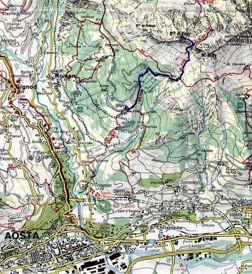
Getting There
BY CAR:
- From TORINO, MILANO, etc: Motorway A5. Exit at IVREA or Quincinetto (PIEDMONT).
- From IVREA Town: in West (Southern side) towards Pont Saint Martin, Donnas, Bard, Champdepraz, Pontey, Fénis, Nus to Quart-Villefranche and Saint Christophe Municipalities (Eastern Side).
- From Courmayeur Resort: in East towards Pré Saint Didier, Morgex, Arvier, La Salle, Saint Pierre, Sarre, Aosta to Saint Chistophe and Quart Municipalities (Western Side).
Specific Road From Aosta Est toll of the highway towards Aosta City and, just after the local small airport, turn to the right toward Saint Christophe Municipality (615m). Follow (take care) signs for Sorreley Hamlet (790m) . A little before it turn to the left and, after passing the Village of Veynes (841m) and the next or almost concomitant Villages of Cretallaz (1.087m), Jeanceyaz (1.092m) and Morgonaz (1.174m), and Prayon oppure Praillon (1.280m) follow up to Chamerod old Village (1.634/38m) located at the foot of Combe de Senevé also Cénevé, but with the route surely closed in winter.
Dall'uscita del Casello dell' Autostrada di Aosta Est proseguire verso la Città di Aosta e, subito dopo aver superato l'Aeroporto Corrado Gex, svoltare a destra verso il Comune di Saint Christophe (615 m) . Seguire attentamente i cartelli per la Frazione di Sorreley (790 m) ; poco prima di arrivarci svoltare sulla sinistra e proseguire verso il Villaggio di Veynes (841 m) , (lasciato a sinistra il bivio per Blavy, cartello Montagne). Continuare a salire oltrepassando i quasi concomitanti Villaggi di Cretallaz (1.087 m), Jeanceyaz (1.092 m) e Morgonaz (1.174 m) e il successivo di Prayon oppure Praillon (1.280 m), dove al tornante seguente inizia la strada poderale con cartello di divieto; salire ancora sino a raggiungere il vecchio Villaggio di Chamerod (1.634/38 m) posto ai pedi della Combe de Senevé, trovando sicuramente la strada chiusa nella stagione invernale.
Route
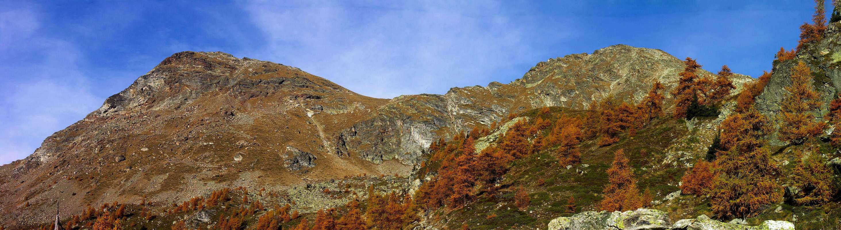
Reached and crossed Chamerod ancient Villagealong an ancient comfortable muletrack that, rounding to NE, leads to Alpe Les Prèles also better known by the local inhabitants as Les Preyes (1.795m). Going on in the same direction, using a steep path, you get a further mountain pasture in the middle of a wood. Passing West of the fork to Alpe Chavod (2.020m), follow till the pastures beyond the Alpe di Senevé (2.199m) and get it. Form this pasture go Northwest on pastures and scree towards the Colle di Chamerod or, even and maybe better, Southwestern Chaudière Pass (about 2.740/42 meters), between Mont Mary (2.815m) and the two unnamed Summits called Punte de Les Prèles, before Colle Chaudière (2.680m). After passing the boring Southeastern slopes of Mont Mary and keeping more to the right (North-northeast), you go around some rocky banks and through a rocky grassy gully you reach the fairly narrow notch of Colle Chaudière Southwest just beyond a series of four teeth (see photo above top); from this point you continue towards the North as well as integrally and easily along the edge of the ridge, which at the end has some short climbs or at least where you can also use your hands (I°), and then finish on debris up to the Summit. This excursion is however somewhat more appreciable if carried out with hardened and well transformed snow. As for the starting point, the one from Chamerod is better, because it is more direct than the one starting from Avisod Village (1.398m) in Trois Villes; but it must be remembered that while the latter can be reached by car, the itinerary through Chamerod (1.614/15m) actually starts from the hairpin bend immediately after the Praillon or Prayon Pastures (1.280m) , where the dirt farm road starts but with a sign prohibiting unauthorized vehicles.
 |
 |
 |
Raggiunto l'antico Villaggetto di Chamerod, oggigiorno ristrutturato, attraversarlo seguendo un'antica mulattiera che comodamente, con giro a Nordest, porta all'Alpe Les Prèles anche meglio conosciuta dagli abitanti delle varie località ai piedi della Comba di Senevé, oppure Cénevé, siccome Les Preyes (1.795 m); continuando nella stessa direzione, per un sentiero abbastanza ripido si raggiunge un'ulteriore alpeggio diroccato nel mezzo del bosco, oltre il quale, lasciando ad est la diramazione per l'Alpe Chavod (2.020 m), porta ai pascoli sottostanti l'Alpe di Senevé (2.199 m) che in breve si raggiunge. Dall'alpeggio puntare a Nordovest su pascoli alternati a pietraie in direzione del Colle di Chamerod oppure, anche e forse meglio, Col Chaudière Sudovest (2.740/42 metri circa), tra il Mont Mary (2.815 m) e le due elevazioni precedenti il Colle Chaudière Nordest (2.680 m), dette Punte de Les Prèles. Superati i noiosi pendi Sudorientali del Mont Mary e tenendosi maggiormente sulla destra (Nord-nordest) si aggirano alcune banconate rocciose e per un canalino erboso roccioso si perviene all'abbastanza stretto intaglio del Colle Chaudière Sudovest appena oltre una serie di quattro dentini (vedi foto sopra in alto); da questo punto si prosegue verso Settentrione nonché integralmente e facilmente sul filo della cresta, che al termine presenta qualche breve tratto arrampicabile o perlomeno dove si possono usare anche le mani (I°), per poi terminare su detriti fino alla Vetta. Questa gita é comunque alquanto più apprezzabile se effettuata con neve indurita e ben trasformata. In quanto al punto di partenza é migliore quello da Chamerod, perché più diretto di quello con inizio dal Villaggio di Avisod (1.398 m) a Trois Villes (1.390 m); ma bisogna ricordare che mentre questo ultimo é raggiungibile in auto, l'itinerario attraverso Chamerod (1.614/5 m) in realtà prende inizio dal tornante subito dopo l'Alpeggio di Praillon o Prayon (1.280 m), dove parte la strada poderale, ma con cartello di divieto ai mezzi non autorizzati.
ALTERNATIVE ROUTE: But the route, if not more logical, certainly more comfortable is to start from the "Penne Nere" Bivouac (2.730m) just above the Colle di Viou (2.696m). In fact, having reached the same, positioned near a small Summit called Mont Trembloz (about 2.720 meters), through the path n° 5 in the initial part up to Alpe Foillou (2.073m) and then with the intervalleys path n° 105 which climbs from Valpelline in Grand Combin locality (942m) or, on the opposite side, from the path n° 1A/25 or the intervalleys path always n° 105 with departures from the small Village of Blavy (1.471/74 meters, in Saint Christophe Municipality) or by the Municipality of Roisan in Crétaz location (907m) through a farms dirt road, you can make the excursion in a day or with bivouac in the same shelter, breaking the excursion into two days. In the following climb to Mont Mary with the easy NW Crest (be careful, however, if it is covered with ice or with snowy frames generally on the right or South), and then again easily descend with the NE Crest to Col Chaudière SW, whence as in the previous itinerary to the Summit (3h'00 to Bivouac, 0h'30 for the crossing on Mont Mary; altogether 3h'45'/4h'00).
VIA ALTERNATIVE: Ma la via, se non più logica, sicuramente maggiormente comoda consiste nel partire da Bivacco "Penne Nere" (2.730 m) appena al di sopra< del Colle di Viou (2.696 m). Infatti, raggiunto il medesimo, posizionato vicino ad una piccola Sommità denominata come Mont Trembloz (2.720 metri circa), tramite il sentiero n° 5 nella parte iniziale fino all'Alpe Foillou (2.073 m) ed in seguito con il sentiero intervallivo n° 105 che sale da Valpelline in località Grand Combin (942 m) oppure, sul versante opposto, dal sentiero n° 1A/25 o sentiero intervallivo sempre n° 105 con partenze dal Villaggetto di Blavy (1.471/74 metri, Comune di Saint Christophe) o dal Comune di Roisan in località Crétaz (907 m) con strada sterrata interpoderale, si può compiere l'escursione in giornata oppure bivaccare nel medesimo spezzando la gita in due giorni. Nel seguente salire al Mont Mary con la facile Cresta NO (attenzione però se ricoperta da ghiaccio o con cornici nevose in genere a destra o Sud), per poi ancora facilmente scendere con la Cresta NE al Col Chaudière SO, donde come nel precedente itinerario alla Sommità (3h'00 al Bivacco, 0h'30 per la traversata del Mont Mary; in totale 3h'45/4h'00).
When to Climb
In all seasons or Spring, Summer, Fall and Winter.
In tutte le stagioni, ovvero Primavera, Estate, Autunno ed Inverno.
Equipment & Difficulties
Standard mountaineering equipment.
Normale da montagna.
The Normal Route: is assessable as easy hiking for all hikers with an experience pratice of middle-mountain (F/F+).
La Via Normale é da valutarsi adatta ad ogni tipo di escursionista con un pò di pratica di media-montagna (F/F+).
Campings
Remember that free camping is forbidden (except for emergency reasons, over 2.500m, from darkness until dawn).Mountain Condition
- Meteo: you can find all the needed informations at the official site of the Valle d'Aosta Region:
- Valle d'Aosta Meteo
Books and Maps
- "Guida dei Monti d'Italia - Alpi Pennine (Vol. 2)" di Gino Buscaini - Club Alpino Italiano/Turing Club Italiano, Luglio 1970 (In Italian).
- "Ascensioni 1964-1969" Diario Alpinistico di Ilario Antonio Garzotto (unpublished).
- "Diari Alpinistici" di Osvaldo Cardellina e Indice Generale accompagnato da Schedario Relazioni Ascensioni 1964-2019 (unpublished).
 |
 |
- Kompass "Breuil/Cervinia-Zermatt" Carta turistica 1:50.000.
- I.G.C. Istituto Geografico Centrale "La Valpelline" (carta n° 115) Map1:30.000.
- I.G.M. Istituto Geografico Militare - Map1:25.000.
- L'Escursionista Ed. Rimini "Gran San Bernardo-Ollomont" (carta n° 5) 1: 25.000.
Important Information
- REGIONE AUTONOMA VALLE D'AOSTA the official site.
- FONDAZIONE MONTAGNA SICURA Villa Cameron, località Villard de la Palud n° 1 Courmayeur (AO) Tel: 39 0165 897602 - Fax: 39 0165 897647.
- SOCIETA' DELLE GUIDE DELLA VALPELLINE Etroubles-Strada Nazionale, n° 13 - Tel +39 0165 78559 - Valpelline-Loc Capoluogo, n° 1 - Tel +39 0165 713502 (AO) Italia.
- A.I.NE.VA. (Associazione Interregionale Neve e Valanghe).
Useful numbers
- Protezione Civile Valdostana località Aeroporto n° 7/A Saint Christophe (Ao) Tel. 0165-238222.
- Bollettino Valanghe Tel. 0165-776300.
- Bollettino Meteo Tel. 0165-44113.
- Unità Operativa di Soccorso Sanitario Tel. 118.