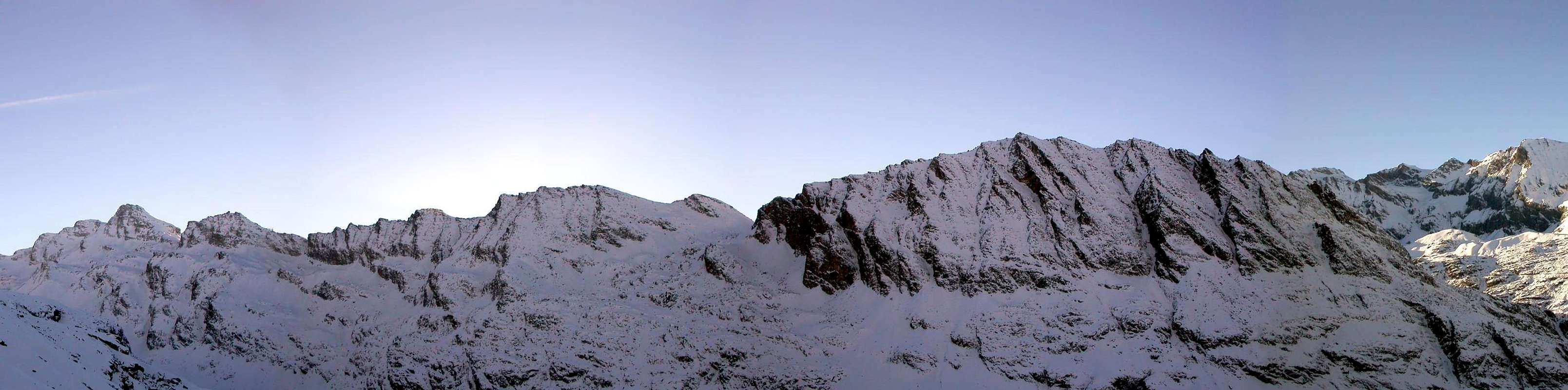
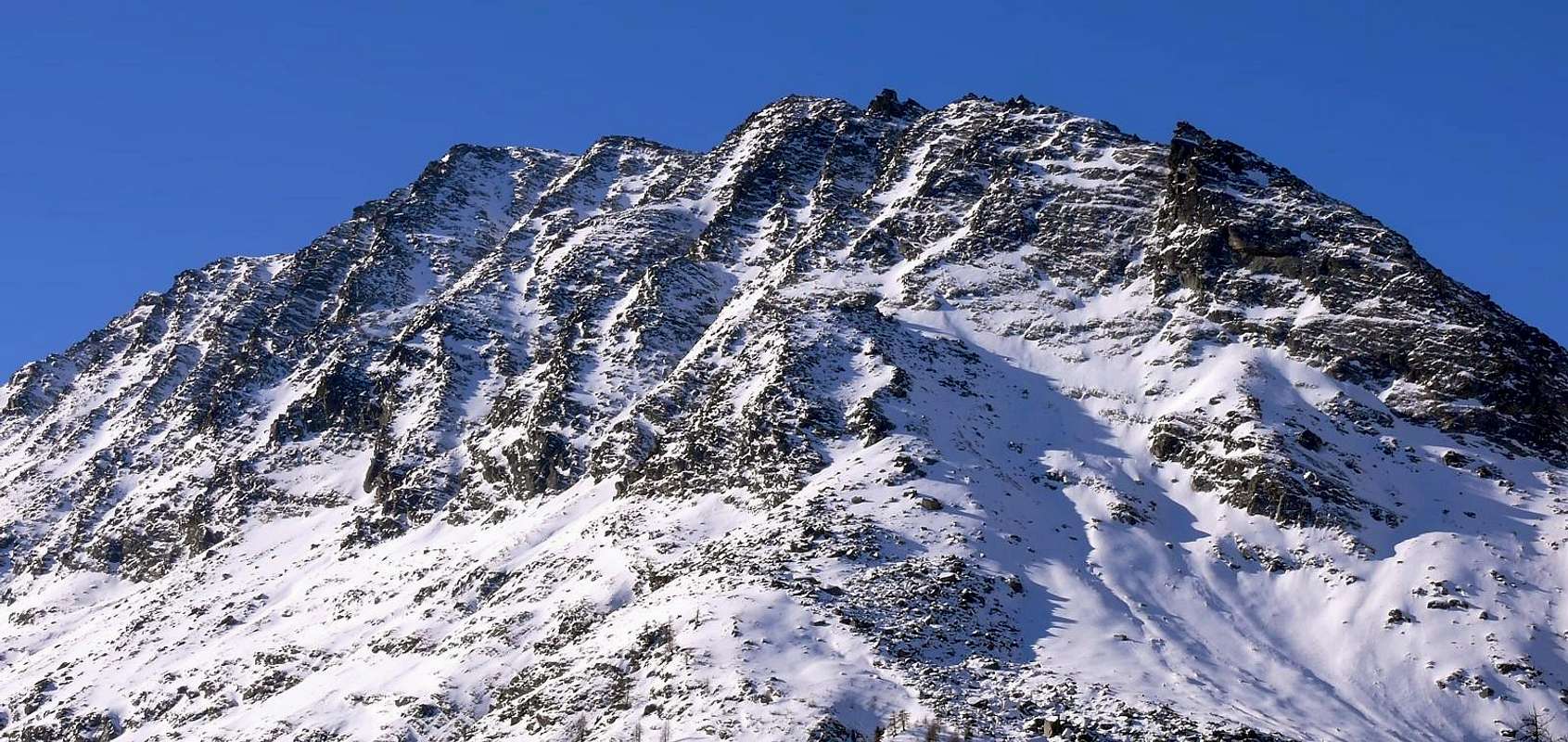
This summit (little lower than 3.000m) almost disappears into the wide environment of Gran Paradiso Group but is just a great panoramic point on it. This mountain is the first one above Pont di Valsavarenche on the ridge building the Grand Collet, the Monte Giansana, the Cime di Seiva and the Punta Fourà, dividing the Seiva Valley (E) from the Nivolè Plain (W).
Montagna di quasi 3.000 metri, sparisce nel contesto della grandiosità della Catena del Gran Paradiso, sulla quale costituisce un gran punto panoramico. E' la prima vetta incombente sopra Pont di Valsavarenche; della costiera formante via via il Grand Collet, il Monte Giansana, il Colle e le Cime di Seiva, il Colle e la Punta Fourà ed è atta a separare il Vallone di Seiva (E) dal Pian del Nivolè (W).
First Ascents
First on the summit: Unknown.
In Winter: Unknown.
N Arête (from Croce de la Roley): Osvaldo Cardellina, Alessandro Cardellina and Christian Cardellina, (Aug 15th, 1991).
NW Slope: Osvaldo Cardellina, Alessandro Cardellina and Christian Cardellina, (Aug 15th, 1991), in descent.
Integral Crossing (from Punta de la Roley to Punta Fourà): Osvaldo Cardellina, Christian Cardellina, Marco Cossard and Giuseppe Lamazzi, (Aug 14th, 1983).
Getting There
BY CAR:
From France: through the Mont Blanc Tunnel or the Col du Petit Saint Bernard: you can drive on SS.26, following directions for Aosta and, before arriving in Villeneuve, turn right towards Introd. Alternatively, you can take Motorway A5 (at Courmayeur or Morgex) and exit at Aosta Ovest.
From all the other directions: get to the Aosta Ovest exit of Motorway A5. Then drive on SS.26 Aosta, in the direction of Courmayeur; just after Villeneuve turn left towards Introd.
BY PLANE:
Aeroporto "Corrado Gex" Saint Christophe (Aosta).
Shortly after Introd, you arrive at a junction: turn left, entering Valsavarenche, and passing through many Villages (Degioz, Eaux Rousses, etc.) you can arrive at Pont (1.964m) where the road ends.
Route
From Pont di Valsavarenche (1.964m) a comfortable mule track starts just behind the Hotel. Toward West into the narrow valley of the Doire Stream of Nivolè and, along a ramp, get the Croce de la Roley (2.313m), (good panoramic point). Follow zigzagging into the big banks of rock, polished by ancient glaciers, entering the Nivolè Plain, (a big highland long more than 6km ending with two fine lakes (2.526m and 2.537m) and the Nivolè Pass joining the Valsavarenche with the Ceresole Valley (Piemonte) Two Refuges here: Savoia 2.610m and Chivasso. Along this plain up to the many twists of the Doire Stream and, before the Montagna Grand Collet (2.409m), start ascending toward East, without tracks, on grassy slopes, debris and big rocky blocks toward the summit (2h'30/3h'00).
DESCENT: Retrace the route or along the S ridge to Grand Collet then down to the Montagna Grand Collet.
Da Pont di Valsavarenche (1.964 m) prendere la comoda mulattiera che parte subito dietro l'Albergo; salire verso W lo stretto valloncello della Doire (torrente) del Nivolè e con una rampa finale raggiungere la Croce de la Roley (2.313 m), ottimo punto panoramico e fotografico. Si continua a serpentina tra grandi banconate di splendida roccia levigata dall'antica erosione glaciale "entrando" nel Pian del Nivolè, grande altipiano di oltre 6 km utile al pascolo; al termine dello stesso l'omonimo colle, preceduto da due bei laghi (2.526 m e 2.537 m), porta nella Valle di Ceresole in Piemonte (Rifugi Savoia 2.610 m e Chivasso proprio al colle). Percorrere un tratto del famoso pianoro sin dove la Doire effettua numerose anse, senza raggiungere la Montagna Grand Collet (2.409 m), e risalire verso E il versante W senza percorso obbligato per tratti erbosi, detriti e grandi blocchi accatastati puntando direttamente alla cima (2h'30/3h'00).
DISCESA: Lungo la stessa via di salita oppure per la cresta S al Grand Collet e alla Montagna Grand Collet.
Difficulty
No difficulties.
L'itinerario è classificato F.
Gear
Hiking gear.
Da escursionismo.
Red Tape
Within the borders of the P.N.G.P. (Parco Nazionale del Gran Paradiso), at the moment dogs generally are not allowed, except on a couple of trails, and camping is forbidden (except for climbers from sunset till dawn). No fees are due.
"I Rifugi della Valle d'Aosta" di Stefano Ardito, Ed. Guide iter, Febbraio 2003.
"Parco Nazionale del Gran Paradiso" di Stefano Ardito, Ed. Guide iter, Novembre 2001.
"Guida delle Alpi Occidentali", di Giovanni Bobba e Luigi Vaccarone C.A.I. Sezione di Torino Volume II (parte II), 25 Maggio 1896.
"Gran Paradiso", A. Gegenfurtner, G. Klotz, F. Müller, Ed. Bergverlag Rudolf Rother, Monaco 1980 (in tedesco).
"Gran Paradiso", G. Klotz, Ed. Bergverlag GmbH Rother, Monaco 2005 (in tedesco).
"Diari Alpinistici" di Osvaldo Cardellina e Indice Generale accompagnato da Schedario Relazioni Ascensioni 1964-2019 (inediti).
"Rifugi e bivacchi in Valle d'Aosta", di Cosimo Zappelli aggiornata da Pietro Giglio, Musumeci Editore, Luglio 2002.
"Guida della Regione Autonoma Valle d'Aosta" di Mario Aldrovandi,Ed. S.P.E. di Carlo Fanton, Torino 31 Dicembre 1964.
"Guida dei Monti d'Italia-Gran Paradiso Parco Nazionale" E. Andreis, R. Chabod, M. C. Santis, Club Alpino Italiano/Touring Club Italiano, prima Ed. 1939; seconda Ed. 1963; terza Ed. 1980.
MAPS:
Kompass "Gran Paradiso Valle d'Aosta Sentieri e Rifugi" Carta Turistica 1:50.000.
L'Escursionista "Valsavarenche Gran Paradiso Carta dei Sentieri" (n° 9) 1:25.000.
Meridiani Montagne "Gran Paradiso" 1:25.000.
Enrico Editore Ivrea-Aosta "Gruppo del Gran Paradiso" 1:50.000.
L'Escursionista "Valle di Cogne Carta dei Sentieri" 1:25.000.
L'Escursionista "Tour de la Vallée de Cogne Grand Paradis" 1:25.000.
I.G.C. Istituto Geografico Centrale "Parco Nazionale del Gran Paradiso" 1:50.000.
Studio F.M.B. "Gran Paradiso" Bologna 1:50.000.
I.G.C. Istituto Geografico Centrale Torino "Valsavarenche Val di Rhêmes Valgrisenche P.N.G.P.", 1:25.000.
A.I.NE.VA. (Associazione Interregionale Neve e Valanghe).
Useful Numbers
Protezione Civile Valdostana località Aeroporto n° 7/A Saint Christophe (Ao) Tel. 0165-238222.
Bollettino Meteo (weather info) Tel. 0165-44113.
Unità Operativa di Soccorso Sanitario (Emergency Medical Assistance). Phone: 118.
Acknowledgements
I am greatly indebted to my friend I am greatly indebted to my friend "Osva" for the detailed description of the route. I am greatly indebted to my friend Gabriele Roth for the translation of the text from italian.
Parents refers to a larger category under which an object falls. For example, theAconcagua mountain page has the 'Aconcagua Group' and the 'Seven Summits' asparents and is a parent itself to many routes, photos, and Trip Reports.

 5943 Hits
 87.31% Score
 24 Votes