-
 2053 Hits
-
 80.49% Score
-
 12 Votes
|
|
Mountain/Rock |
|---|---|
|
|
45.80490°N / 7.40299°E |
|
|
Mountaineering, Trad Climbing |
|
|
Summer |
|
|
9573 ft / 2918 m |
|
|
Note
|
La montagna chiama i suoi figli, ed essi rispondono fedelmente al suo appello… Osvaldo Cardellina, Diario alpinistico, 1964-65 Page texts: @ OsvaldoCardellina "Osva", passed away on May 2, 2022. Page owners: Christian Cardellina e Osvaldo Cardellina. Any updates from September 12, 2022: Antonio Giani, page administrator, friend and climbing companion. Testi della pagina: @ OsvaldoCardellina "Osva", scomparso il 2 maggio 2022. Proprietari pagina: Christian Cardellina e Osvaldo Cardellina. Eventuali aggiornamenti dal 12 settembre 2022: Antonio Giani, amministratore della pagina, amico e compagno di salite. |
Abbot Overview
This Summit it is an intermediate node topographic minor, in fact from it originate two ridges to the North in the direction of Becca Conge (2.956m) until the Hill of St. Barthélemy (more precisely in the Northeast; 2.638m). The first among these is the border with the Comba Verdona to South of the Municipality of Oyace, after reaching the Col de St. Barthélemy the eponymous Peak (2.868m). The other instead are directed respectively to the South constituting the boundary between Comba Verdzignola (Valpelline) and the Comba Dèche, addressed to the Municipality of Quart in the Central Valley of Dora Baltea. Then formed by two slopes, of which the Western, crossed by a horrid gully-couloir, is divided into at least two distinct sides, while on the other side or Eastern is more "flattened" and shaped sole or, if you prefer , as a catfish. Even this is etched by two rocky gullies that certainly does not invite to climb, because it is object of falling stones. Incidentally all the rock of this mountain is somewhat broken, if not crumbling and unstable, allowing more and more delicate climb that difficult. They are "saving" themselves the two main routes on the ridge:
a) - that of the Northeast Ridge or Normal Route that originated from the St. Barthélemy Hill, although a pass into a notch just below the Becca Conge requires attention;
b) - that of the Southwest Ridge, until now exclusively downhill path, which presents some short sections that forced him to abandon the edge of the ridge forcing small circumvention on the East Slope. This reaches the Summit of the Eastern (2.971m) double Tsaat a l'Etsena, the highest Summit of the whole area. In contrast it is compensated by exceptional views on the entire Chain of Pennine Alps from Mont Blanc to the Monte Rosa Group, passing Grand Golliaz, Mont Velan, the Combins, Dent d'Herens and Matterhorn. In a final note, to point out the beautiful full crossing that can be extended up to the Col de Fana and subsequent and numerous Beaks (2.880m, 2.951m), with a descent from the narrow Collar 2.925 meters can fall within the above Comba Dèche to Alps Seyvaz or Clavel (2.184m, 1.994m) and from these respectively to the Col St. Barthélemy and Oyace Common in Valpelline or Trois Villes Hamlets. This Top was dedicated to Abbé Joseph Marie Henry (* 1870 Courmayeur + Valpelline 1947), Explorer of this neglected and unknown group of mountains between Valpelline and Baltea Valley, Mountaineer, Toponimy Scholar, Botanical, Pastor in Valpelline for 44 years. So by Gino Buscaini in "Pennine Alps Vol. II°", 1970 at page 571.
Questa Sommità costituisce un nodo topografico intermedio di secondaria importanza, infatti da essa si originano due creste verso Settentrione in direzione della Becca Conge (2.956 m) e del Colle di St. Barthélemy (più precisamente a Nordest; 2.638m)). La prima tra queste costituisce lo spartiacque con la Comba di Verdona a Mezzogiorno del Comune di Oyace, raggiungendo dopo il Colle di St. Barthélemy l'omonima Punta (2.868m). L'altra invece si indirizza a Mezzogiorno verso la Vetta Orientale (2.971 m) della duplice Tsaat a l'Etsena, costitutuendo lo spartiacque tra la Comba di Verdzignola (Valpelline) e la Comba Dèche, rivolta sopra il Comune di Quart nella Valle Centrale della Dora Baltea. Quindi forma due unici versanti, dei quali quello Occidentale risulta formato da un ripido canalone suddiviso almeno da due settori ben distinti (due paretine rivolte a Nordovest ed a Sudovest "accompagnate" da rispettivi canaloni), mentre sull'opposto od Orientale appare più "addolcita". Pur essendo anche questo costituito da un ripido versante erboso-roccioso percorso da canaloni minori non certamente invitanti alla salita, anche perché esposti alle cadute di sassi. Inevitabilmente tutte le rocce di questa montagna risultano piuttosto rotte ed instabili e sicuramente maggiormente delicate che non difficoltose da scalarsi. Si "salvano" le due vie principali sopra il divisorio:
a) - quella della Cresta Nordest o Via Normale originantesi dal Colle di St. Barthélemy, segnata da un piccolo intaglio subito precedentemente alla Becca Conge richiede una certa attenzione;
b) - quella Sudovest, da percorrersi direttamente od appena al di sotto, tale da presentare qualche breve tratto che forzatamente obbliga ad abbandonarne il filo con alcuni brevi aggiramenti sul Versante Orientale. Queste caratteristiche, insieme alla lunghezza degli approcci sia partendo dalla Comba Dèche che dalla Valpelline, fan sì che questa Cima sia veramente poco conosciuta e scarsamente frequentata anche dagli alpiniti locali. Per contro viene compensata da vedute eccezionali sull'intere Alpi Pennine dalla Catena del Monte Bianco fino a quella del Monte Rosa, oltrepassando Grand Golliaz, Mont Velan, i Combins, Dent d'Hérens e Cervino. Ultima annotazione, da segnalare la bella traversata integrale che può essere protratta fino al Col di Fana ed ai successivi e numerosi Becchi (2.880 m, 2.951 m), con discesa che dal Colletto 2.925 metri permette il rientro nella Comba Dèche sopra le Alpi La Seyvaz o Clavel (2.184 m, 1.994 m) donde rispettivamente al Col St. Barthélemy ed Oyace in Valpelline od ai Villaggi di Trois Villes al di sopra della Collina di Quart. Questa Cima é stata dedicata all'Abbé Joseph Marie Henry (* Courmayeur 1870 + Valpelline 1947), Esploratore di questo negletto e sconosciuto gruppo di montagne, Alpinista, Studioso di Toponomastica, Botanico nonché Parroco in Valpelline per 44 anni. Così da parte di Gino Buscaini in "Alpi Pennine Vol. II°", del 1970 alla pagina 571.
First Ascents
- First on Summit: Osvaldo Cardellina and Giuseppe Lamazzi (Aug 20th, 1978), in ascent from St. Barthélemy Hill.
- In Winter: unknown.
- Great Complete Traverse: from St. Barthélemy Hill-Becca Conge by Northeast Ridge-Quota 2.918 meters or Punta Henry crossing North/South-Eastern Tsaat à l'Etsena by North Crest-Pass and Becchi di Fana integral traverse round trip (Western Antesummit 2.945 meters, Collar 2.925 meters, Central 2.951 meters, Second 2.945 meters, Third 2.940 meters, Fourth or Eastern 2.938 meters): Osvaldo Cardellina and Giuseppe Lamazzi (Aug 20th, 1978); in descent North Face of Collar 2.925 metres.
Getting There
BY CAR:
- From TORINO, MILANO, etc: Motorway A5. Exit at IVREA or Quincinetto (PIEDMONT).
- From IVREA Town: in West to Pont Saint Martin, Donnas, Bard, Verrès, St. Vincent, Châtillon, Nus, Quart, St. Christophe, Aosta and Roisan Municipalities. From Courmayeur Resort: in East to Morgex, La Salle, Saint Pierre, Sarre, Aosta, Roisan and Saint Chistophe Municipalities. From Aosta Town towards Quart and Nus Municipalities
- 1) - By Quart-Villair to Epilaz, Argnod Villages or from SS.26 nearby La Plantaz (540m), with Regional and Municipal Roads, towards Chétoz, Vignil, Fornail, Ville sur Nus-Planeville, Buignod, Porsan Villages to Trois Villes-Avisod Village (1.398m). From this towards La Seyvaz, Valchourda Alps (2.206m), in Comba Dèche.
- 2) - From Quart to Fonteil with previous route; this through dirt road, towards La Seyvaz (2.184m), Valchourda Alps (2.392m), in Comba Dèche. From Nus-La Plantaz in State Road to Ville sur Nus-Planeville (1.113m); from this, towards Buignod, Avion (1.312m) Villages. Also from Porsan through Trois Villes (1.398m), Avion, fork (1.250m) to Effraz Village (1.487m), with Municipal Roads. From this to Ronc (1.737m), Machaussy Alps, in Effraz Comba. From Aosta towards Valpelline Valley
- 3) - From Aosta City with SS.26 towards the alternative before Gignod Municipality; from this through the Regional Road in Northeast towards Valpelline Commune (580m) and always through Regional Road, towards Oyace Commune (1.316m - 1.377m). From these to Southern Vallons:
- a) - by Valpelline towards Verdzignola and
- b) - by Oyace towards Verdona Vallon.
- From FRANCE: through the Mont Blanc Tunnel to Entrèves-crossroads to Vény/Ferret Valleys - Mountain Guides of Courmayeur - La Saxe Rock Gym - Courmayeur. By Little Saint Bernard Pass, closed since November until half May to La Thuile Valley - Pré Saint Didier - Courmayeur. It is not necessary to take Motorway A5: you can drive on SS.26, in the direction of AOSTA - IVREA - TURIN.
-
BY PLANE:
- Aeroporto "Corrado Gex" Saint Christophe (Aosta).
-
Approach & Routes
![]()
-
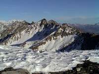
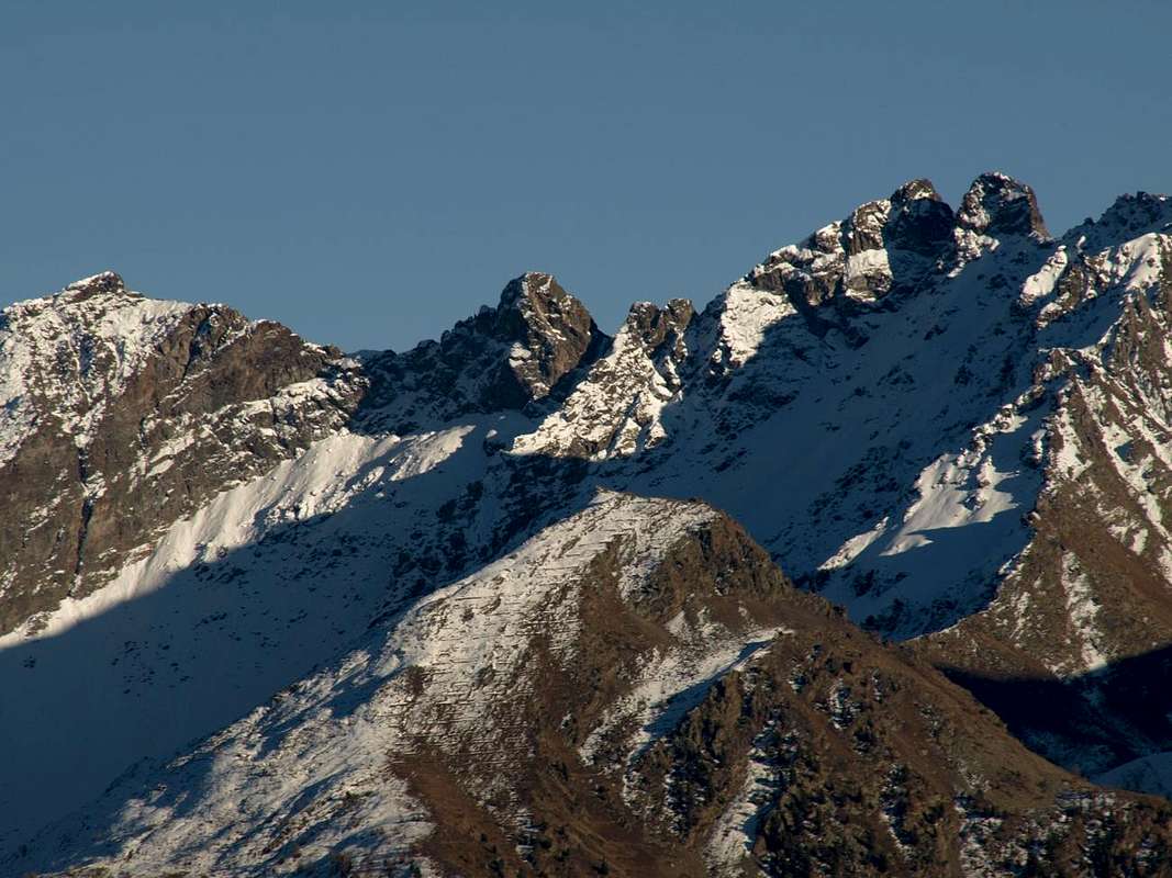
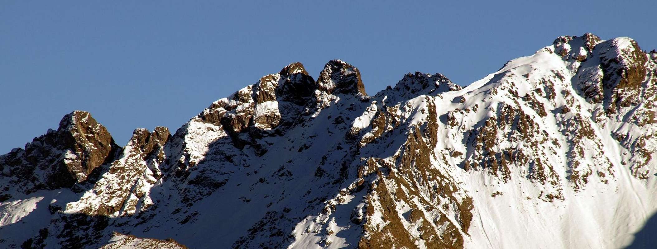
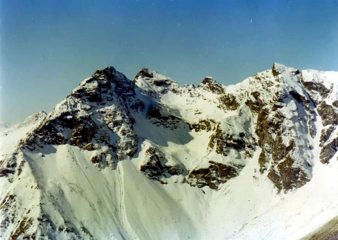
Approach from Trois Villes-Fonteil Village: over the triple Village of Trois Villes, and now the interior of St. Barthélemy Valley, opens the Comba Dèche, that has a vertical depth reaching the hill with the same name. As well as very important Pass (2.639m) towards the Valpelline and Oyace Common, between Becca Conge (2.954m) and Punta Verdona (2.868m) and just before the beautiful pyramid of Mount Faroma (3.073m), now belonging fully to this valley. An aggregation perhaps, for this comba, somewhat arbitrary but certainly practical for even the farm private dirt road that runs, concomitant with the trail n° 3/4 on valley floor, reaching in succession the mountain Pastures of Nouva, Flemagne, Salé, Cré, Brunier, Clavel towards upper La Seyvaz and Valchourda Alpages (2.184m, 2.392m) and finally the St. Barthélemy Hill (2.639m; E/; 4h'00/4h'30 by Fonteil) leave just from Trois Villes beginning immediately above of Fonteil Village (1.423m; mini parking). (EEA/F+/PD-; 4h'00/4h'30). By St. Barthélemy Pass and through the watershed Comba Dèche with Valpelline Valley on Northeast Ridge or Normal Route: from the hill turn in the Southwest and perform the divide with the Comba Verdona (above Oyace Municipality in the adjacent Valpelline Valley) through easy rocks and some traces spread up to a first altitude 2.826 meters, outflanked on the right (North) and then the Antesummit Northeast (2.914m); from this point becomes the same partition with the Comba Verdzignola (above Valpelline Common) and exceeding a cut of about 12/15 meters (II°/II°+ on edge of the ridge) ends at Becca Conge with the Northeast Ridge, formed by blocks easy but dangerously stacked balanced very unstable. A short and easy descent (I°+) leads, after passing to the East a small rocky wall, a carving called Colle di Verdzignola (2.871m), really were not transitable; follows a fairly aerial crest that overlapped with reddish blocks (II°-) leads to the Peak on which it is not no passing signal was found. (EEA/F+/PD-; 2h'30/2h'45 from St. Barthélemy Hill; 3h'20/3h'40 by Valchourda Alp; 6h'30/7h'00 overall by Fonteil). Wanting to continue the journey down with the opposite ridge or the Southwest reaching another notch followed by two successive small bumps (II°/II°-), above which on the ridge or just below it joins up with the final part (I°) of Normal Route to the Eastern Tsaat a l'Etsena (2.967m), from which then you can go down again towards the Comba Dèche through the Col de Fana (2.880m; A/F+; 0h'40 crossing by Pointe Henry to the East Tsaat a l'Etsena; 2h'15/2h'30 for descent in Comba Dèche; 3h'00/4h'00 to Trois Villes-Fonteil).
-
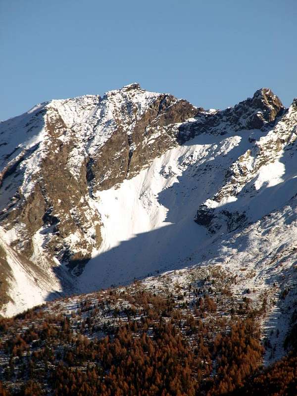
![]()
t. Barthélemy Hill (in center; 2.638m) with Northeast Crest or Normal Via (to the left) Avvicinamento dal Villaggio di Trois Villes-Fonteil Village: oltre il triplice Villaggio di Trois Villes (Porsan, Avisod e Fonteil), ed ormai internamente alla Valle di Saint Barthélemy, si allunga la Comba Dèche, che possiede una profondità in verticale raggiungendo l'omonimo nonché molto importante Colle verso la Valpelline (2.639 m), collocato tra la Becca Conge (2.954 m) e la Punta di Verdona (2.868 m) ed appena prima della bella piramide del Monte Faroma (3.073 m), ormai appartenente in modo completo a questa valle. Una aggregazione forse, quella di questa comba, un poco arbitraria ma sicuramente pratica poiché anche la strada poderale ed il concomitante sentiero n° 3/4 che la percorrono raggiungendo in successione le Alpi di Nouva, Flemagne, Salé, Cré, Brunier, Clavel, la Seyvaz e Valchourda (2.184 m, 2.392 m) ed infine il Colle di St. Barthélemy con Oyace e la Valpelline (2.639 m; E/; 4h'00/4h'30 da Fonteil) partono proprio da Trois Villes con inizio al Villaggio appena superiore di Fonteil (1.423 m; mini parcheggio). Dal Colle di St. Barthélemy tramite la Cresta Nordest o Via Normale: dal colle volgere a Sudovest e seguire lo spartiacue con la Comba di Verdona (sopra Oyace in Valpelline) tramite facili rocce e qualche traccia sparsa fino a raggiungere dapprima la Quota 2.826 metri, aggirabile sulla destra (Nord) e poi l'Antecima Nordest (2.914 m); da questo punto il medesimo diventa divisorio con la Comba Verdzignola (sopra Valpelline) e superando un intaglio di 12/15 metri circa (II°/II°+ sul filo) si conclude alla Becca Conge con la Cresta Nordest, formata da blocchi facili ma pericolosamente accatastati in equilibrio alquanto instabile. Una breve e facile discesa (I°+) conduce, dopo avrere aggirato ad Est un piccolo salto roccioso, ad un intaglio chiamato Colle di Verdzignola (2.871 m) peraltro non transitabile; segue una cresta abbastanza aerea che con blocchi rossicci sovrapposti (II°-) conduce alla Vetta sulla quale non é stato rinvenuto nessun segnale di passaggio. (EEA/F+/PD-; 2h'30/2h'45 dal colle; 3h'20/3h'40 dall'Alpe Valchourda; 6h'30/7h'00 da Fonteil). Volendo continuare la traversata scendere con la Cresta opposta o Sudovest raggiungendo un altro intaglio seguito da due successive piccole asperità (II°/II°-), superate le quali sul filo di cresta od appena al di sotto ci si ricongiunge con la parte finale (I°) della Via Normale alla Tsaat a l'Etsena Orientale (2.967 m), dalla quale poi si può scendere nuovamente verso la Comba Dèche tramite il Col de Fana (2.880 m; A/F+; 0h'40 per la traversata dalla Pointe Henry alla Tsaat a l'Etsena Orientale; 2h'15/2h'30 per la discesa in Comba Dèche; 3h'00/4h'00 sino a Trois Villes-Fonteil).L'itinerario è da classificare in EEA/F+/PD- (Escursionisti Esperti od Alpinisti).![Becca di Viou]()
![Becca Conge & P. Herry above Verdzignola Vallon 2015]()
![Chain from Bca Conge up to the Pointe de Senevé 2015]() Da Alto Escursionismo, meglio se con corda.
Da Alto Escursionismo, meglio se con corda. - You can get meteo information at the official site of the Regione Valle d'Aosta:
- Valle d'Aosta Meteo
- "Guida della Valpelline" de l'Abbè Joseph-Marie Henry - Societè Editrice Valdotaine 1925 II Edition e Collana Reprint Musumeci (1986).
- "Guida dei Monti d'Italia - Alpi Pennine (Vol. 2)" di Gino Buscaini - Club Alpino Italiano/Turing Club Italiano, Luglio 1970 (In Italian).
- "80 itinerari di Escursionismo Alpinismo e Sci Alpinismo in Valle d'Aosta", di Osvaldo Cardellina, Ed. Musumeci, Giugno 1977 (in Italian); seconda Ed. Luglio 1981; terza Ed. Luglio 1984; (in French), prima Ed. Febbraio 1978; seconda Ed. Marzo 1980.
- "Dove andiamo in montagna? in Valle d'Aosta" di Domenico Caresio Edit. Tipografia Ferraro Ivrea, Marzo 1996.
- "Diari Alpinistici" di Osvaldo Cardellina e Indice Generale accompagnato da Schedario Relazioni Ascensioni 1964-2019 (unpublished).
-


- Kompass "Breuil/Cervinia-Zermatt" Carta turistica 1:50.000.
- I.G.C. Istituto Geografico Centrale "La Valpelline" (carta n° 115) Map1:30.000.
- I.G.M. Istituto Geografico Militare - Map 1:25.000.
- L'Escursionista Ed. Rimini "Gran San Bernardo-Ollomont" (carta n° 5) 1: 25.000.
- REGIONE AUTONOMA VALLE D'AOSTA the official site.
- FONDAZIONE MONTAGNA SICURA Villa Cameron, località Villard de la Palud n° 1 Courmayeur (AO) Tel: 39 0165 897602 - Fax: 39 0165 897647.
- SOCIETA' DELLE GUIDE DELLA VALPELLINE Etroubles-Strada Nazionale, n° 13 - Tel +39 0165 78559 - Valpelline-Loc Capoluogo, n° 1 - Tel +39 0165 713502 (AO) Italia.
- A.I.NE.VA. (Associazione Interregionale Neve e Valanghe).
- Protezione Civile Valdostana località Aeroporto n° 7/A Saint Christophe (Ao) Tel. 0165-238222.
- Bollettino Meteo (weather info) Tel. 0165-44113.
- Unità Operativa di Soccorso Sanitario Tel. 118.