
-
 6166 Hits
-
 85.87% Score
-
 21 Votes
|
|
Mountain/Rock |
|---|---|
|
|
45.87400°N / 7.35912°E |
|
|
Mountaineering |
|
|
10932 ft / 3332 m |
|
|
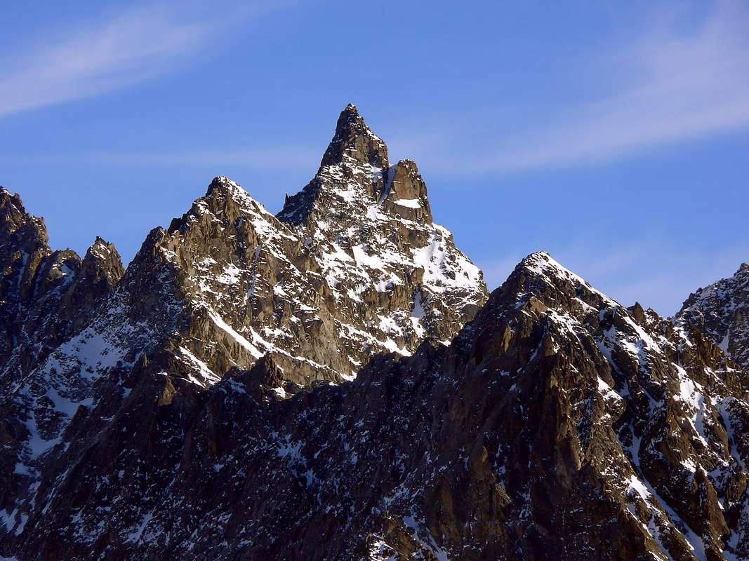
Overview
Fine pyramid, above all seen from Southeast (Valpelline little Tourist Town), from where in the shape of "Aiguille". Sited to South of long Mount Gelé/Mount Morion Buttress, where this change direction from N/S briefly to West for to finish again in Southwest, upon Valpellines inhabited. Formed, prefect triangular pyramid, by three crests and as many faces to Northwest, Eastsoutheast and Southwest. Good views toward By Conca (= By Basin), Ollomont Valley and Valpelline whole, but especially great sight to Mont Vélan Group and Himalayan Great Combins Mountain Chain.
Bella piramide, soprattutto se vista da SE (Valpelline), ove svetta a mò di "Aiguille". Situata a sud del lungo Contrafforte Mont Gelé/Mont Morion, dove questo cambia direzione da N/S brevemente in W, per poi finire, nuovamente a SW sopra l'abitato di Valpelline. Presenta, da perfetta piramide triangolare, tre creste ed altrettante pareti. Grandi viste sulla Conca di By, la Valle di Ollomont e la Valpelline; ma, soprattutto, sul Gruppo del Mont Velan e sull'himalayana Catena dei Combins.
 |
First Ascents
- First on the summit (W-Arête): Ettore Canzio, Felice Mondini, Nicola Vigna and Giacomo Noro, (Aug 21th, 1895).
- In winter: Vincenzo Di Dato and Company in the end of Seventies.
- S Side (normal route): abbots Joseph Henry and Lyabel Perron, (Nov 28th, 1906), from Valpelline.
- N-NE Arête: T. Ashby, T. G. Longstaff, P. Georges, Jean Maître and Pierre Maurys, (Aug 25th, 1897).
- E Wall: Basilio Ollietti, Guido Perolino, and Ernesto Piccone, (Aug 1932).
Getting There
BY CAR:- From Torino, Milano, etc: Motorway A5. Exit at Aosta Est.
- From Switzerland: through the Grand Saint Bernard Tunnel or the namesake pass.
- From France: through the Mont Blanc Tunnel or Petit Saint Bernard Pass. It is not necessary to take Motorway A5: you can drive on SS.26, in the direction of Aosta.
BY PLANE:
- Aeroporto "Corrado Gex" Saint Christophe (Aosta).
Approachs
Approach 1) : From Valpelline-Sémont (1.061m), go up by North direction and through path n° 3 toward Bas Brison Alp (1.485m); to cross the Brison Torrent doubling by half circular route in Northnortheast direction to Dzone-Zoon Alp (1.695m). By Northnortheast direction to cross the Dialley Wood reaching the Brison Alp (2.195m) as well as the path higher Route n° 1 from Oyace.Da Valpelline-Sémont (1.061 m), risalire con direzione N e tramite il sentiero n° 3 verso l'Alpe Bas Brison (1.485 m); attraversare il Torrente di Brison doppiando con percorso semicircolare in direzione N-NE verso l'alpe Dzone-Zoon (1.695 m). Con direzione N-NE attraversare il Bois de Dialley raggiungendo l'Alpe Brison (2.195 m) ed il sentiero Alta Via n° 1, proveniente da Oyace.
Approach 2) : From Oyace-Close (1.457m), by Westnortwest direction and path of Higher Route n° 1 toward Suchéaz Pasture (1.995m) to reach the Brison Alp (1h'15/1h'30).
Da Oyace-Close (1.457 m), con direzione W-NW e sentiero dell'Alta Via n° 1 verso l'Alpe Suchéaz (1.995 m) raggiungere l'Alpe Brison (1h'15/1h'30).
Approach 3) : From Ollomont-Cognen (1.356m) to start at once behind the Churc by grounroad concomitant with the path n° 6, 7, Higher Route n° 1; go up, by Northeast direction, leaving in left of Berrio Torrent the with same name lower pasture (1.720m; small path, level route), To reach this way the Higher Berrio Alp (1.932m), on good and panoramic tableland; change direction in Southeast, leaving in left the path 6, toward Cornet Pass (2.654m), and, by a long diagonal before in Southsoutheast, after in East to reach the Brison Pass (2.470m~). From pass before to descend in East toward Brison Comba (=Basin), after, by Southeast direction, to rejoin the previous routes.
Da Ollomont-Cognen (1.356 m) prendere subito dietro la Chiesa la strada poderale concomitante con il sentiero n° 6, 7, Alta Via n° 1; salire con direzione NE, lasciando a sinistra del Torrente Berrio l'omonimo alpeggio inferiore (1.720 m; piccolo sentiero in quota). Raggiungere così l'Alpe di Berrio Damon (1.932 m), in una bella e panoramica spianata; cambiare direzione in SE, lasciando il sentiero 6 per il Col Cornet (2.654 m) a sinistra, e, con un lungo diagonale, prima verso S-SE, poi ad E raggiungere il Col de Brison (2.470 m~). Dal colle scendere dapprima verso E nella Comba di Brison e quindi, con direzione SE, raggiungere gli itinerari precedenti.
 |
 |
 |
 |
 |
Route
From Brison Pasture to change direction in Northwest and by of Higher Route path to direct one's steps toward Brison also Breuson Pass (2.195m); before to reach the with the same name Comba (= Basin), to abandon in quota (3.200m), where this turn definitely in West. Go up to North along the torrent by traces and, after, moraines into the long and steep great valley, between the of Berrio Mount SW Buttress in left (West) and the S Ridge descending from Fiorio Point to Aimé Gorret Point for the end at Cross (2.629m), up Meulet Tableland and her alp (2.287m). Go up always North direction up to of torrent sources (2.754m); leaving in left b(West) the route toward Berrio Pass (3.006m), turn in Northnortheast reaching the narrow and steep basin, below the Quaini Pass (3.220m~) and between Quaini Head/Fiorio Point. Climb toward of Fiorio Point W-SW Crest between there and Gorret Point, reaching a "carving" hardly over (North) the Clocherot Pass (3.220m~), near a typical pinnacle. Go up easily to left getting before a rocky strip (15/20m; I°+); to follow again without difficult the gully following contra of yellowish tower wall; doubling in right moving on a second sinuous and snowy couloir and to reach a balcony between the Summit and Antesummit. Climb by a fissure and cross in right (East) to "carving" between the two summits (III°); to overcome the higher edge in vertical ascent also leaving in left (Northwest) (5 meters; IV°, one pitons, or III°-) going up inclined balcony. By rotten and broken rocks in the shape of blocks on North Slope to Summit (7h'00/8h'00; 1h'30; for terminal part from Col des Clocherots).Dall'Alpe Brison (2.195 m) cambiare direzione in NW e con il sentiero dell'alta Via indirizzarsi verso il Col Brison o Breuson; prima di raggiungerne l'omonima Comba, abbandonarlo a quota (2.300 m), ove questo gira decisamente ad W. Risalire invece verso N lungo il torrente tramite tracce e poi morene il lungo e ripido vallone compreso tra il Contrafforte SW del Monte Berrio a sinistra e la Cresta S che dalla Punta Fiorio scende alla Punta Aimé Gorret per terminare alla Croce (2.629 m), sopra Plan Meulet e la sua alpe (2.287 m). Risalirlo, sempre con direzione N sino alle sorgenti del torrente (2.754 m); lasciando a sinistra la via per il Col de Berrio (3.006 m), girare a N-NE raggiungendo lo stretto e ripido bacino sotto il Colle Quaini (3.220 m~) e tra la Testa Quaini e la Punta Fiorio. Arrampicare verso la cresta W-SW della Punta Fiorio tra questa e la Punta Gorret, raggiungendo un intaglio appena sopra (N) il Col des Clocherots, presso un caratteristico gendarme. Risalire facilmente verso sinistra superando dapprima una fascia rocciosa di 15/20 m (I°+); seguire ancora senza difficoltà il successivo canale sin contro il muro di un torrione giallastro, che si aggira sulla destra (E) portandosi in un secondo canale sinuoso e nevoso e raggiungere un balcone tra la Cima e l'Anticima O. Salire una fessura e traversare verso destra (E) all'intaglio tra le due sommità (III°); vincere lo spigolo soprastante in verticale o evitarlo a sinistra (NW) (5 m; IV°; 1 chiodo, oppure III°-) arrivando su di una placca pendente. Per rocce rotte e blocchi sul Versante N raggiungere la Vetta (7h'00/8h'00; 1h'30 per la parte finale dal Col des Clocherots).
Difficulty
This route can be considered AD+.Da alpinismo, casco, corda.
Campings
Remember that free camping is forbidden (except for emergency reasons, over 2.500m, from darkness until dawn).
Mountain Conditions
- You can get meteo information at the official site of the Regione Valle d'Aosta:
- Valle d'Aosta Meteo
Webcam
- WEBCAM on Aosta Valley:
- Webcam
Books and Maps
BOOKS:- "Guida delle Alpi Occidentali", di Giovanni Bobba e Luigi Vaccarone C.A.I. Sezione di Torino Volume II (parte II), 25 Maggio 1896.
- "Guida dei Monti d'Italia-Alpi Pennine" (Vol. I°) di Gino Buscaini-Club Alpino Italiano/Turing Club Italiano, Luglio 1971 (in Italian).
- "Guida della Valpelline" de l'Abbè Joseph-Marie Henry - Societè Editrice Valdotaine 1925 II Edition e Collana Reprint Musumeci (1986).
- "Rifugi e bivacchi in Valle d'Aosta" di Cosimo Zappelli aggiornata da Pietro Giglio. Musumeci Editore, Luglio 2002 (in Italian).
 |
 |
 |
- Kompass "Breuil Cervinia Zermatt" Sentieri e Rifugi Carta turistica 1:50.000.
- L'Escursionista "Valpelline, Saint Barthélemy" (carta n° 6) 1:25.000.
- I.G.C. Istituto Geografico Centrale "La Valpelline, Ollomont, Saint Barthélemy", (carta n° 115) Map1:30.000.
- Carta Nazionale Svizzera "Foglio Valpelline" 1:50.000.
Important Information
- REGIONE AUTONOMA VALLE D'AOSTA the official site.
- FONDAZIONE MONTAGNA SICURA Villa Cameron, località Villard de la Palud n° 1 Courmayeur (AO) Tel: 39 0165 897602 - Fax: 39 0165 897647.
- SOCIETA' DELLE GUIDE DELLA VALPELLINE Etroubles-Strada Nazionale, n° 13 - Tel +39 0165 78559 - Valpelline-Loc Capoluogo, n° 1 - Tel +39 0165 713502 (AO) Italia.
- A.I.NE.VA. (Associazione Interregionale Neve e Valanghe).
Useful numbers
- Protezione Civile Valdostana località Aeroporto n° 7/A Saint Christophe (Ao) Tel. 0165-238222.
- Bollettino Meteo (weather info) Tel. 0165-44113.
- Unità Operativa di Soccorso Sanitario Tel. 118.