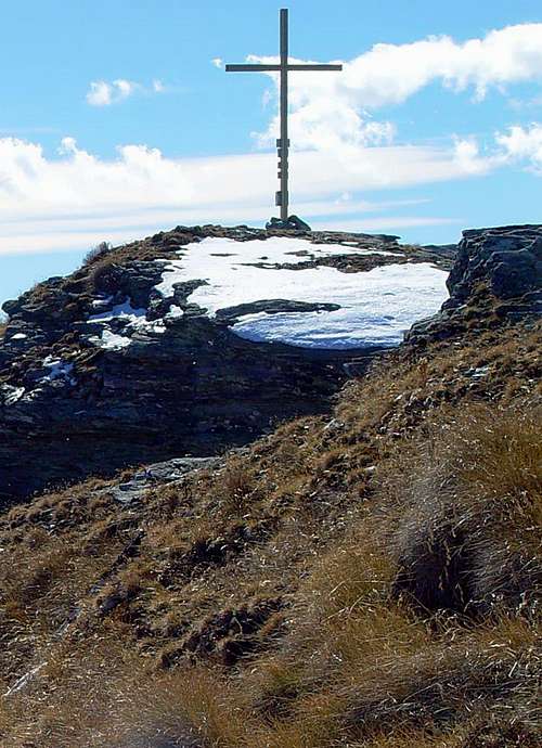
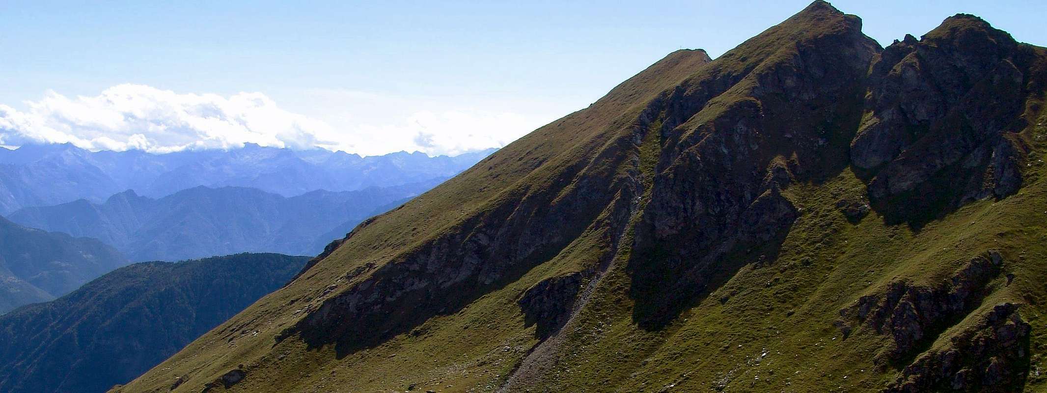
This Summit is located at the extreme southern edge of the small spur that descends from the Corno Bussola (3.023m; Kompass Horn), the highest elevation of this whole area marked by the numerous Lakes of Palasina or Palasinaz. The same rather on the underlying falls to East Lake Bringuez in the small basin with the same name, while in the Southwest dominates the Common and the plain of Brusson, into the mid Val d'Ayas, with a high wall of more than 300 meters. Due to the bad quality of the rock, little comes granted the Mountaineering although the Spur South-southwest of the same has been traced a valid itinerary of about 300 meters in winter 1973, 8th March by Guido Botto, Edward Ferrero and Paolo Moretti. The normal of ascent is the case from the East Slope, just above the lake above dates back over easy grassy slopes with some falling rocks, to circumvent other, between Punta Gua or even Guà and Monte Palon (2.776 meters about), often confused with the first or assimilated to it. Towards Brusson elevates a typical gendarme known locally as "la femme de Gua", or "the female or the wife of Gua", which in turn means spire. So as to Becca Monciair and other Summit it illogical it is a repetition of the name, since Gua or Guà of already distinguishes a Tip. Beautiful views of the Municipality of Brusson, the ridge dividing the Val di Ayas from that of Gressoney between the Testa Grigia - Mont Nery and Dames de Challand and on Eastern Graian, while in the north the view of the other lakes are hidden by the ridge Quota 2.899 meters down to Southeast reaching the Monte Chiappa (2.684m).
Questa Sommità è collocata allo estremo margine Meridionale del piccolo contrafforte che scende dal Corno Bussola (3.023 m), la più alta elevazione di tutta questa area contraddistinta dai Laghi di Palasina o Palasinaz. La stessa invece incombe ad Oriente sul sottostante Lago di Bringuez dentro lo omonimo piccolo bacino, mentre a Sudovest domina il Comune e la piana di Brusson con un'alta parete di oltre 300 metri. Causa la cattiva qualità della roccia, poco vien concesso allo Alpinismo anche se sullo Sperone Sud-sudovest della stessa é stato tracciato un valido itinerario di 300 metri nell'inverno del 1973 da parte di Guido Botto, Edoardo Ferrero e Paolo Moretti, il 18 di Marzo. La via Normale di salita avviene invece dal Versante Est, proprio al di sopra del lago suddetto e risale sopra facili pendii erbosi con qualche roccetta, per altro aggirabile, tra la Punta della Gua od anche Guà ed il Monte Palon (2.776 metri circa), spesso confuso con la prima od assimilato alla stessa. Verso Brusson eleva un caratteristico gendarme conosciuto in loco come "la femme de Guà", ovvero "la femmina o la moglie della Guà", che a sua volta significa guglia. Quindi come per la Becca di Monciair ed altre Sommità si tratta di una illogica ripetizione del nome, poiché il toponimo di Gua o Guà contraddistingue di per se stesso già una punta ben definita. Belle vedute sul Comune di Brusson, la cresta divisoria la Val di Ayas da quella di Gressoney tra la Testa Grigia-Mont Nery e Dames de Challand e sulle Alpi Graie Orientali, mentre a Settentrione la vista sugli altri laghi viene occultata dalla cresta che dalla Quota 2.899 metri scende verso Sudest raggiungendo il Monte Chiappa (2.684 m).
First Ascents
First on the Summit: Unknown.
In winter: Unknown.
South-southwest Spur: Guido Botto, Edoardo Ferrero and Paolo Moretti, (March 18th, 1973).
Complete traverse from Corno Vitello, Punte di Palasina, Punta del Lago, Corno Bussola and Pass, Quote 2.899, 2.859, 2.855, 2.759 meters, Pointe Palon and Punta della Gua: Osvaldo Cardellina, lone, (Jul 07th, 2002).
Getting There
BY CAR:
From TORINO, MILANO: follow Aosta direction on Motorway A5, exit in Verres.
From IVREA Town: in West (Southern side) to Pont Saint Martin, Verrès Municipalities in East from Aosta Town.
From Courmayeur Resort: in East-southeast to Aosta, Nus, Chatillon, Saint Vincent, Verrès Municipalities.
BY PLANE:
Aeroporto "Corrado Gex" Saint Christophe (Aosta).
Specific Road
From Verrès to Val d'Ayas Valley, from Verrès (549m), with Regional Road, to Challant Saint Victor (765m), Challant Saint Anselme (1.060m), Brusson (1.332m) Municipalities. From Brusson continue East through a Regional Road up to the Estoul Fraction (1.815m), under Bringhez-Palasinaz Area. From France: through the Mont Blanc Tunnel to Entrèves/Courmayeur. By Little Saint Bernard Pass, closed since November until half May to La Thuile Valley - Pré Saint Didier - Aosta - Verrès Municipalities. It is not necessary to take Motorway A5: you can drive on SS.26, in the direction of AOSTA - IVREA - TORINO.
Approaches and Route
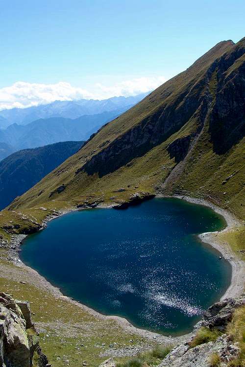
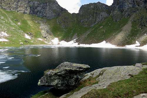
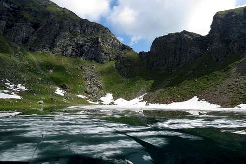
Bringuez or Brenguez Lake (2.529m) is placed in a narrow basin between the Tips of the Guà and Palòn to the West and Mount Chiappa East.
1) - It can be reached directly from Brusson towards West the Torrent Messuère, the "Hole of the Fairies" and subsequent Alpages Mandaz, Raccard, Lavassey where, turning in opposite to the Northwest, you come to Quiappa Alp (2.245m) and the junction with 2.352 meters the following path (E; 3h'30/4h'00).
2) - Or with the private dirt farms road that reaches from Estoul-Fenillettaz tiny Village (1.840m; sign ban on driving to the next junction 1.882 meters; source) and, after Fontaine, Chanlochère, Chavanne Pastures and fording the Ru (Brook/Torrent) Dialley, reaches beyond the Vallon Lavassey Alp (1.996m; spring; (E; 3h'00/3h'15), and after the previous routes from valley floor. In our humble opinion, this is the ultimate way to be preferred, even if it involves a small loss of altitude in the crossing of the gorge-vallon; in each case the other two routes offer beautiful walks in unspoilt nature and little known to the masses. Gua or Guà Summit (2.778m): Eastern Slope and Northern Crest in terminal part starting from Bringuez Lake (2.529m). Climb West from the lake through the easy grassy slopes with a small trace of the path not numbered; exceeded an insignificant rock band, continue with two possibilities: a)- to go directly to the small saddle 2.733 meters at Pointe Palòn and continue along the easy Northern Crest; 2)- diagonally across the East-northeast Slope of scattered traces reaching the big Cross Summit (E/F; 0h'45/1h'00 from the loch; 3h'30/3h'45 from Estoul).
Il Lago di Bringuez o Brenguez (2.529 m) è posto in un ristretto bacino tra le punte del Guà e Palon ad Ovest e il Monte Chiappa Oriente.
1) - Vi si accede direttamente da Brusson verso Occidente ed il Torrent Messuère, il "Buco delle fate" ed successivi Alpeggi di Mandaz, Raccard, Lavassey dove, girando all'opposto in Nordovest, si arriva all'Alpe Quiappa (2.245 m) ed all'incrocio a 2.352 metri del percorso successivo (E; 3h'30/4h'00).
2) - Oppure tramite la strada privata e poderale che raggiunge da Estoul il Villaggetto di Fenillettaz (1.840 m; cartello di divieto ai mezzi presso il successivo bivio 1.882 metri con sorgente) e che, dopo gli Alpeggi di Fontaine, Chanlochère, Chavanne guadando il Ru (ruscello d'irrigazione) Dialley, va oltre il vallone dell'Alpe Lavassey (1.996 m, sorgente, (E; 3h'00/3h'15), ed oltre i percorsi precedenti con partenza dal fondovalle. A nostro modesto parere, questo risulta come il miglior itinerario, anche se comporta una piccola perdita di quota nella traversata della gola-vallone; in ogni caso gli altri percorsi offrono bellissime passeggiate nella natura incontaminata e poco conosciuta alle masse. Punta della Gua oppure Guà (2.778 m): tramite il Versante Orientale e la Crestina Settentrionale nella parte terminale partendo dal Lago Bringuez (2.529 m). Dal lago salire verso Ovest attraverso facili pendii erbosi con una piccola traccia non numerata; superata un'insignificante fascia rocciosa, continuare con due possibilità: a) - andando direttamente alla selletta 2.733 metri verso la Pointe Palon e proseguire lungo la facile cresta Nord; 2) – attraversare in diagonale il versante Est-nordest su tracce sparse raggiungendo la grande Croce di Vetta (E/F; 0h'45/1h'00 dal lago; 3h'30/3h'45 da Estoul).
Difficulty
This route can be considered E/F or EE/F+ (Experts Hikers) in winter (even by snowshoes or Ski).
L'itinerario è da classificare in E/F oppure EE/F+ (Escursionisti Esperti) in inverno (anche tramite Racchette da neve od in Scialpinismo).
Equipment
Hiking gear, in winter as for Ski-Mountaineering or with Snowshoes.
Da Escursionismo, in inverno da Scialpinismo o con Racchette da neve.
Campings
Remember that free camping is forbidden (except for emergency reasons, over 2.500m, from darkness until dawn).
Mountain Conditions
You can get meteo information at the official site of the Regione Valle d'Aosta:
Parents refers to a larger category under which an object falls. For example, theAconcagua mountain page has the 'Aconcagua Group' and the 'Seven Summits' asparents and is a parent itself to many routes, photos, and Trip Reports.

 2190 Hits
 81.18% Score
 13 Votes