

-
 6380 Hits
-
 90.48% Score
-
 32 Votes
|
|
Mountain/Rock |
|---|---|
|
|
46.47507°N / 12.07939°E |
|
|
Veneto |
|
|
Hiking, Trad Climbing, Sport Climbing |
|
|
Summer, Fall |
|
|
8717 ft / 2657 m |
|
|
Overview
Geographical classification: Eastern Alps > Dolomites > Lastoni di Formin > Punta Lastoi or Spitz de Mondeval
Punta Lastoi - Spitz de Mondeval m. 2657
Punta dei Lastoi m. 2657, also called Spitz de Mondeval, is the culminating peak of the amazing massif of Lastoni di Formin, located between the Croda da Lago-Cernera Group and Passo Giau, one of the highest road pass of the Dolomites. It shows a stunning South oriented face, emerging in the Southern sector of Lastoni di Formin.

It's a wonderful and steep wall of high quality yellow and black “dolomia", starting from Forcella Giau and overlooking the amazing meadows of Mondeval.


Different trad and modern routes run side by side along this wall, quite deserving a visit inreason of their exposition, the quality of the rock and the spectacular wide views over the Pelmo Group and the others breathtaking surrounding peaks.
Getting There
The starting point to climb Punta Lastoi is Passo Giau m. 2236, one of the highest pass of the Dolomites, located 16 km to Cortina d’Ampezzo, the main resort in this area and can be approached from Trento, Bolzano or Belluno.
Road access to Passo Giau m. 2236
- From Trento and Verona: take the Brennero Motorway towards North, exit Ora-Egna, then follow the road to Val di Fiemme and Val di Fassa, pass Cavalese and Predazzo; in Moena leave the main road and turn to right, following the Val di S. Pellegrino road to Falcade and Cencenighe Agordino. Here turn to left following the road to Alleghe, Caprile, Selva di Cadore, Passo Giau.
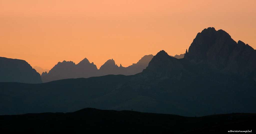
Looking West from Passo Giau at sunset
- From Bolzano: take the Brennero Motorway towards North, exit Ponte Gardena and then follow the Val Gardena road to Selva di Val Gardena and Passo Gardena, reaching Corvara and La Villa. Turn to right towards Passo Falzarego, get the pass and here descent towards left along the road SS48 towards Cortina d’Ampezzo as far as Pocol. In Pocol turn to right and follow the road to Passo Giau (signpost).
- From Belluno: follow the road SS 51 towards North reaching Longarone and Pieve di Cadore; from Pieve the SS51 turns to left, getting to San Vito di Cadore and Cortina d’Ampezzo. Take the road SS48 to Falzarego Pass and in Pocol turn to left (signpost Passo Giau), following the Road SP638 to Passo Giau (16 km. from Cortina).


Walking access to Punta Lastoi
From the little Chapel of S. Giovanni Guadalberto on Passo Giau m. 2236 (parking) follow the path n. 436 to Forcella Zonia and Forcella Col Piombin; after a traverse and a short descent the path rises to Forcella Giau m. 2360.


Leave the main well worn path which descends in the middle of the amazing basin of Mondeval and take on the left a narrow track mainly horizontal, skirting the close South face of Punta dei Lastoi to the various starting points of the routes. (1 hour from Passo Giau).
Punta Lastoi main routes
Punta Lastoi main routes overview from left to right
Approach to the routes: from Forcella Giau m. 2360 leave the main well worn path descending to the amazing basin of Mondeval and head to left towards the walls, taking a narrow track, mainly horizontal, and skirting to the right the close South face of Punta dei Lastoi to the various starting points of the routes (45 minutes from Passo Giau to Forcella Giau, plus 10 minutes to the start of the routes).


- Via Hoi-Nau on Left Spur V+, VI (A0) 315 m. Trad route - First ascent: K. Hoi, H. Nau 1985
- Via Re Artù 6b max, 300 m – Modern route - First ascent: Mario Dibona and co.
- Love my dogs 7a max, 6b obbl., 300 m - Modern route - First ascent: Mario Dibona e Gretchen Alexander, 2005
- Via del Diedro Nero (Black Dihedral) V+, VI (A0) 270 m. Trad route - First ascent: K. Hoi, H. Nau 1985
- Via Scoiattoli VI-, VI+ (A0) 340 m. Trad route - M. Alverà, P. Pompanin, C. Menardi 1977


Descent from Punta dei Lastoi
There are two ways to come back:
- the shortest one is rapping (3 x 25 meters) within a large gully just on the right of the summit cairn, getting soon to the bottom of the wall
- a longer way without rapping is take the Normal route of Lastoni di Formin, a nice hike across the karst tableland leading to the Forcella Rossa, where a path descents to the Alpe di Mondeval and then rises to Forcella Giau


Useful info: the grades of the trad routes are expressed in the UIAA scale, the modern ones in French scale
Red Tape
No permits, no fees and no particulary restrictions in hiking and climbing.
The whole area had been acknowledged as a mountainous area of universal value and included inside the Unesco World Heritage natural sites list. It requires the best care and respect. On SP you can find more info about Dolomiti Unesco World Heritage in my article: Dolomites living mountains
Unesco official website: Dolomiti Unesco
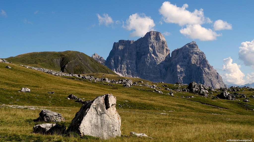
Alpe di Mondeval and Pelmo
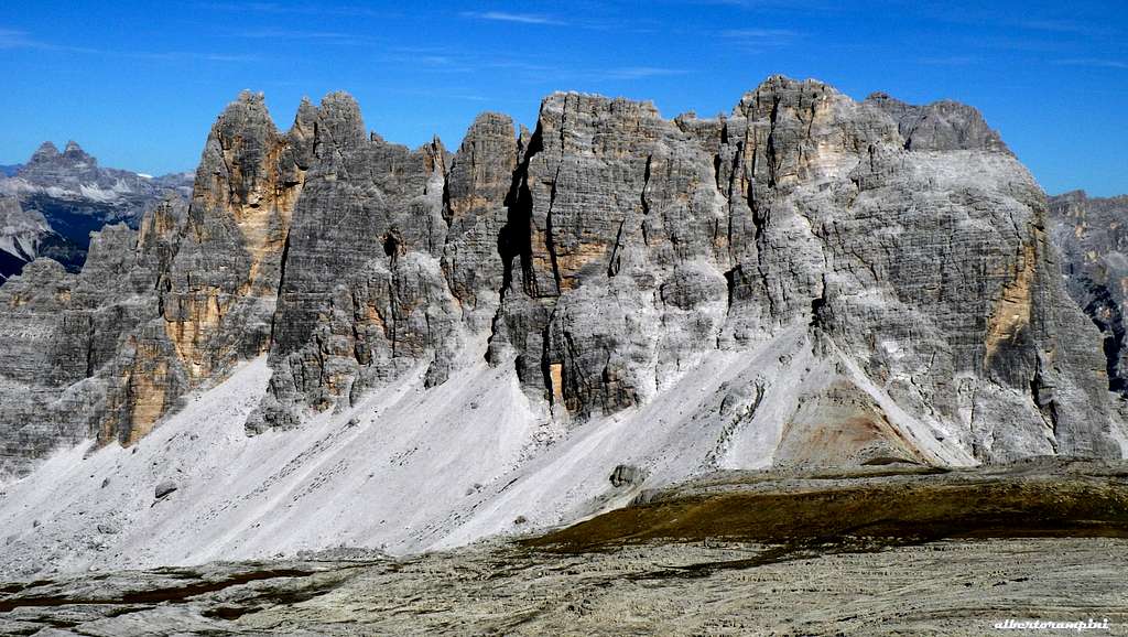
The Croda da Lago Group and the summit tableland
When to Climb
Best season goes from June to the end of September
Where to stay

- Passo Giau Hut m. 2236 Rifugio Passo Giau
- Several other possibilities in Cortina d’Ampezzo and surroundings
Meteo
ARPAV Dolomiti Meteo
Dolomiti Meteo Veneto
ARPAV DOLOMITI METEO Phone +390436780007 fax +390436780008
CENTRO VALANGHE DI ARABBA Phone +390436755711 fax 043679319 e-mail cva@arpa.veneto.it
Guidebooks and maps
Guidebooks


“IV grado e più – Dolomiti Orientali 2” by Emiliano Zorzi – Luca Brigo – Carlo Piovan Idea Montagna Ed.
“Arrampicare a Cortina d’Ampezzo e dintorni – Le vie più belle nelle Dolomiti” by Mauro Bernardi, Ed. Athesia
“Dolomiti Orientali Vol. I – Parte I” by Antonio Berti - Collana Guide dei Monti d’Italia, CAI TCI
Maps
Tabacco sheet 03 – Cortina e Dolomiti Ampezzane 1:25.000 Kompass sheet 55 - Cortina d'Ampezzo 1:50.000