
-
 6308 Hits
-
 87.31% Score
-
 24 Votes
|
|
Mountain/Rock |
|---|---|
|
|
45.87089°N / 7.25510°E |
|
|
Mountaineering |
|
|
10919 ft / 3328 m |
|
|
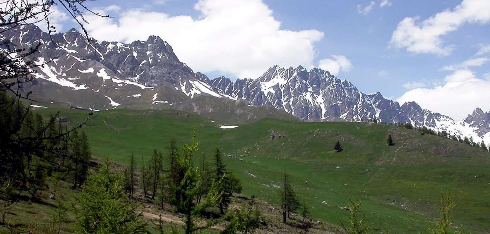
Overview
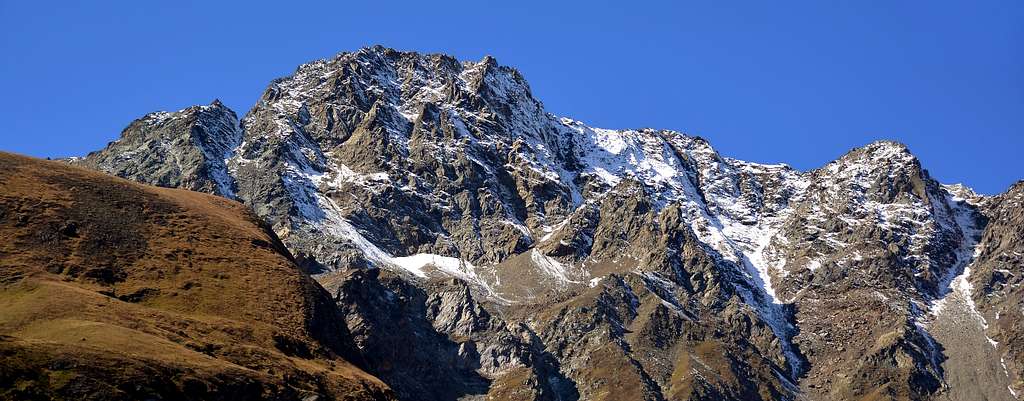
Fine pyramidal shaped mountain, sited half way between Mont Velan and Mont Saron, overlooking the built area of Allain and well visible from Aosta. From its summit a wide view on the close Mont Vélan, on the Gelé-Morion Ridge and on Gran Combin Massif. Seen from the South it appears as a regular as well as isolated pyramid, in which the upper part is constituted by the South Wall, vertical for 110 meters and inaccessible; the same is contained by two edges of which the one on the right or S-SE has already been traveled both uphill and downhill, while the opposite or SW, equally steep but higher and (about 430 meters), is still "virgin". Both in the East and in the West it appears instead as a "squat" and squared mountain with a perfectly rectangular shape: on the East side, above the Conca di Berruard, a wall of broken rocks falls, limited to the left (South) by a clear and long (500m~) rib , which leads to the Southern Summit while further to the North another similar rises in parallel which reaches the Northern Summit (3.218m). On the opposite or Western side, above the Valloni di Menouve and Molline (Etroubles) rises a SW "Crestone" of over 700 meters and which, starting just above Alpe Arvus (1.983m), leads to the Northern Summit of a little less high and (3.218m). To be precise, the same does not directly reach the latter, but the I ° of the three Heads of Faudery, located immediately North of it, even if a few meters away. On this Western side there are three other routes:
a) - the route of the first absolute ascent of the mountain, which runs along the left side (North) reaching the little saddle immediately to the North of the Northern Summit;
b) - in more recent times (October 1996) the right side (South) was instead covered with more difficult climbing and
c) - descent through the adjacent rocky channel between the two aforementioned sectors. View from the North, that is from the Sella di Faceballa (about 2.880 meters) on the Southern Buttress of Mont Velan (3.734 m), instead its mass is confused with the four Points of Faceballa (3.330 meters, the highest) and the three Teste di Faudery (3.310m~, the highest). While the Southern Buttress has already been traveled on several occasions, also starting from Col Champillon (2.708m) and crossing the two Summits of Mont Chenaille em> (Southwest 3.142 meters, Northeast 3.144m) and Tete des Cretes (3.258m), on the Northern one is aware of a single integral route (always on the South / North axis), as well as the partial routes probably made on 7 July 1898 by the first climbers of the Salliaousa (I° and II° Testa di Faudery, Topham Company) and on 7 August 1913 (III°, Ferrario-Semenza consortium) in the first sector and on 7 August 1913 (1°, 2°, Ferrario-Semenza and 4° Punta di Faceballa, same on 5 August) in the second from the Notch-Carving 3.326 meters at Colle (3.239m) and at Saddle of Faceballa (about 2.880 meters).As well as the winter one made solo on 27 December 1983, partially as regards the entire North Buttress, but complete as regards the three Faudery Heads reaching the rocky Carving 3.226 meters, before the start of the four sharp and jagged Punte di Faceballa (Faceballa's Tips). Summit more rarely than scarcely visited, not so much because of the length of the approaches that, nowadays, the farm roads decrease, but because it is unknown to the masses and, perhaps, such as to arouse fear more than necessary, even if in full view. Furthermore, the quality of the rock is poor, except for some stretches.
Bella Montagna a forma di piramide, situata a circa metà tra il Mont Velan e il Monte Saron, dominante l'abitato di Allein e ben visibile dalla Città di Aosta. Dalla sua cima si gode un ottima veduta sul vicino Mont Vélan, sulla Costiera Mont Gelé-Mont Morion e sul Massiccio del Grand Combin. Vista da Meridione appare quale piramide regolare nonché isolata, nella quale la parte superiore é costituta dalla Parete Sud, verticale per oltre 110 metri ed inaccessa; la stessa viene contenuta da due spigoli dei quali quello di destra o S-SE é già stato percorso sia in salita che discesa, mentre l'opposto o SO, altrettanto ripido ma più alto (430 metri~), risulta ancora "vergine". Sia ad Oriente che ad Occidente si presenta invece conme montagna "tozza", squadrata e dalla forma perfettamente rettangolare: sul lato Est, sopra la Conca di Berruard, cade una parete di rocce rotte limitata a sinistra (Sud) da una netta e lunga (500 m~) nervatura, che porta alla Sommità Meridionale mentre più a Settentrione ne sale in parallelo un altra similare che raggiunge la Vetta Nord (3.218 metri). Mentre sul lato opposto od Ovest, al di sopra dei Valloni di Menouve e Molline (Etroubles) sale un Crestone SO di oltre 700 metri e che, iniziando poco sopra l'Alpe Arvus (1.983 m), conduce alla Sommità Settentrionale di poco meno elevata (3.218 metri). Per la precisione il medesimo non raggiunge direttamente quest'ultima, bensì la I° delle tre Teste di Faudery, collocata subito a Nord della stessa, anche se a pochi metri. Su questo lato Occidentale salgono altre tre vie:
a) - la via dei primi salitori assoluti della montagna, che percorre il lato sinistro (Nord) raggiungendo la selletta subito a Settentrione della Sommità Settentrionale;
b) - in tempi più recenti (ottobre 1996) é stato invece percorso il lato destro (Sud) con arrampicata più lunga e leggermente più difficile e
c) - discesa, con inizio dalla cresta sommitale (ma maggiormente nelle vicinanze di questa seconda via), tramite l'attiguo canale roccioso in mezzo ai due succitati settori. Vista da Settentrione, cioé dalla Sella di Faceballa (2.880 metri circa) sul Contrafforte Meridionale del Mont Velan (3.734 metri), invece la sua massa si confonde con le quattro Punte di Faceballa (3.330 metri, la più elevata) e le tre Teste di Faudery (3.310 m~, la più alta). Mentre il Contrafforte Meridionale é già stato percorso in varie occasioni, anche con partenza dal Col Champillon (2.708 metri) e scavalcando le due Sommità del Mont Chenaille (Sudovest 3.142 metri, Nordest 3.144 metri) e della Tête des Crêtes (3.258 metri) nonché il Colle della Salliaousa, su quello Settentrionale si é al corrente di un unico percorso integrale (sempre sull'asse Sud/Nord), oltreché dei percorsi parziali realizzati probabilmente il 7 luglio 1898 dai primi salitori della Salliaousa (I° e II° Testa di Faudery, Comitiva Topham) ed il 7 agosto del 1913 (III°, cordata Ferrario-Semenza) nel primo settore e del 7 agosto 1913 (1°, 2°, Ferrario-Semenza e 4° Punta di Faceballa, idem il 5 agosto) nel secondo dall'Intaglio 3.326 metri al Colle (3.239 metri) ed alla Sella di Faceballa (2.880 metri circa). Nonché dell'invernale realizzato in solitaria il 27 dicembre 1983, parzialmente per quanto riguarda l'intero Contrafforte Nord, ma completo per quanto concerne le tre Teste di Faudery raggiungendo all'Intaglio roccioso 3.226 metri, prima delle quattro aguzze e frastagliate Punte di Faceballa. Sommità più raramente che scarsamente visitata, non tanto per la lunghezza degli approcci che, oggigiorno, le strade poderali diminuiscono, quanto perché sconosciuta alla massa e, forse, tale da incutere timore più del dovuto, anche se in piena vista. Inoltre la qualità della roccia é scadente, fatto salvo qualche tratto.
First Ascent
- First on the Summit: Alfred Georges Topham, Jean Maitre and Pierre Maurys, (Jul 07th, 1898).
- First ascent in winter Osvaldo Cardellina, solo, (Dec 27th, 1983); in ascent from Glacier Hamlet, Berruard, Les Seitives, Chesal, Vieille, Les Econdu Pastures and crossing Faudery Torrent with crossing on three Tête di Faudery (Southern or I° 3310 meters, the highest, Central or II° 2.999 meters, Northern or III° 3.264 meters), round trip on summit crest route; in descent towards Salliaousa's Col, Tête des Crêtes, Mont Chenaille, Col Champillon and Alp, Plan Debat.
- W Wall (to Southern Top): Osvaldo Cardellina and Danilo Garzotto, (Sep 25th, 1994), in ascent from Prailles Dessous Hamlet, fork 1614 meters on Menovy Torrent near Quaye, Menovy Alp, L'Arvus Pastures to Southern Top; in descent from Northern Summit through the Western Couloir of the same face.
- W Couloir (from summit crest): Osvaldo Cardellina and Danilo Garzotto, (Sep 25th, 1994), in descent to Molline/Menouve Vallons, after ascent on West Face.
- SW Ridge (from Menouve/Molline Vallons towards Faceballa's Saddle): Osvaldo Cardellina and Alessandro Cardellina, (Aug 30th, 2005); in ascent from Prailles, Menovy, Arvus Pastures with traverse to three Teste di Faudery and four Punte di Faceballa, Faceballa Col and Saddle; in descent to Molline Bivouac.
- S-E Slope (from Colle of Salliaousa): Abbé Pantaleon Bovet and Abbé Joseph Henry, (Aug 03th, 1904).
- S-SE Edge (Salliaousa Col): Osvaldo Cardellina, (Jun 17th, 1976); in ascent after traverse Col Champillon, Mont Chenaille, Tête des Crêtes, Col de la Salliaousa.
- S-SE Edge (Salliaousa Col): Osvaldo Cardellina and Danilo Garzotto, (Oct 15th, 1996), in descent towards Col de la Salliaousa with crossing to Champillon Hill.
- E Wall (Southern Rib or left route): Osvaldo Cardellina, lone, (Oct 29th, 1988); in ascent from Glacier Hamlet, Berruard, Les Seitives, Chesal, Pleytau, Praz du Champ, Econdu Pastures and crossing Faudery Torrent; in descent towards Ansermin, Crêtes Alps, Voex and Rey Hamlets and Ollomont Village.
- E Wall (Northern Rib or route on right side with traverse on three Teste di Faudery, round trip): Osvaldo Cardellina, solo, (Dec 27th, 1983); in ascent from Glacier, Berruard, Les Seitives, Chesal, Vieille, Econdu; in descent towards Salliaousa Col, Tête des Crêtes, Mont Chenaille, Col Champillon and Alp, Plan Debat.
Getting There
BY CAR:- From Torino, Milano, etc: Motorway A5. Exit Aosta Est.
- From Switzerland: through the Grand St. Bernard Tunnel or the homonym pass.
- From France: through Mont Blanc Tunnel or Petit St. Bernard Pass. It isn't necessary to enter in Motorway A5, you can drive through SS.26 Aosta direction.
- Aeroporto "Corrado Gex" Saint Christophe (Aosta).
Itinerary
From Aosta (583m) along the SS.27 of Gran San Bernardo for about 10km, at a fork turn to the left toward Allein and, after passing Doues, on until the Champillon (2.078m) foreground where the route starts.Dalla Città di Aosta (583 m) si percorre la SS.27 del Gran San Bernardo; dopo una decina di km imboccare sulla sinistra il bivio per il Paese di Allein e, dopo aver superato anche il Paese di Doues, proseguire sino al piazzale di Champillon (2.078 m), dove inizia l’itinerario.
Route
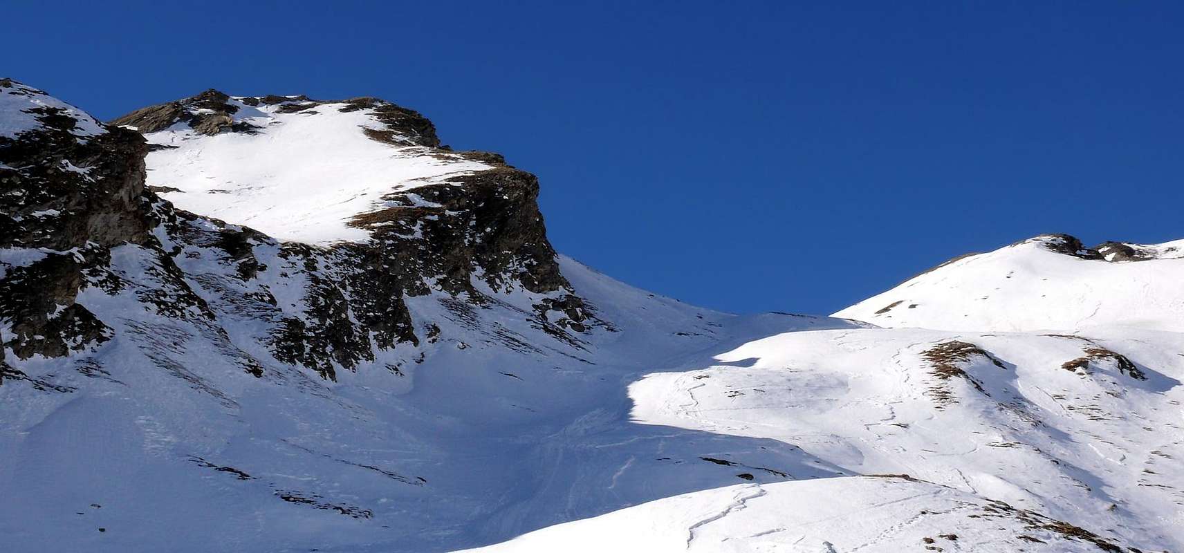
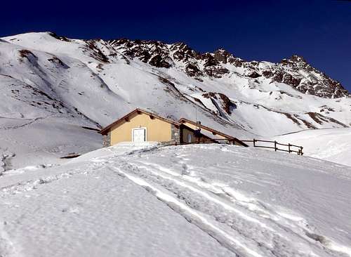
From Champillon (2.078m) follow marks to Rifugio Champillon (2430m) and Colle di Champillon (2.709m) using a well marked path along the combe. Follow to NW and after passing a grassy-debris rise, on tracks, you get the conterfort (2.991m), cross the S and N Summits of Mont Chenaille (3.144m), down on blocks along the N ridge and, after a slab, on along the S ridge up to the Tête des Crêtes (3.212m). Along the ridge cross two more summits to get, slightly descending, the narrow notch named Colle della Salliaousa (3.203m). Cross to the right using a ledge and, after a short channel, up to the S Summit (3.309m). The following ridge, almost 300 meters long, leads to the main summit (3.328m) 4h'00/5h'00.Dal piazzale di Champillon (2.078 m) salire il sentiero che conduce al Rifugio Champillon (2.430 m); proseguire fino a Colle di Champillon (2.709 m) e su comodo sentiero risalire l'omonima comba. Continuare verso NW e, dopo aver oltrepassato un dosso erboso-detritico, si raggiunge su tracce di sentiero lo spallone posto a 2.991 m; superate le Vette Sud e Nord del Mont Chenaille (3.144 m), riscendere per blocchi la cresta Nord e, superata una placca, risalire lungo la cresta Sud fino alla Tête des Crêtes (3.258 m). Proseguire in cresta e, superate altre due quote, raggiungere in leggera discesa il Colle della Salliaousa (3.203 m), formato da uno stretto intaglio. Traversare sulla destra una cengia e, risalito un piccolo canale, toccare la Vetta Sud (3.309 m); continuare sul crinale lungo circa 300 metri sino a raggiungere la vetta principale (3.328 m) 4h'00/5h'00.
Difficulty
This route can be considered F+/PD-.L'itinerario è classificato F+/PD-.
MAPS:
Gear
Hiking gear (spare rope).Huts
 |
Campings
Remember that free camping is forbidden (except for emergency reasons, over 2.500m, from darkness until dawn).Mountain Conditions
- Meteo: you can find all the needed informations at the official site of the Valle d'Aosta Region:
- Valle d'Aosta Meteo
Webcam
- WEBCAM on Aosta Valley:
- Webcam
Books and Maps
BOOKS:- "Guida delle Alpi Occidentali", di Giovanni Bobba e Luigi Vaccarone C.A.I. Sezione di Torino Volume II (parte II), 25 Maggio 1896.
- "Guida dei Monti d'Italia-Alpi Pennine" (Vol. I°) di Gino Buscaini-Club Alpino Italiano/Turing Club Italiano, Luglio 1971 (in Italian).
- "Diari Alpinistici" di Osvaldo Cardellina e Indice Generale accompagnato da Schedario Relazioni Ascensioni 1964-2019 (unpublished).
- "80 itinerari di Escursionismo Alpinismo e Sci Alpinismo in Valle d'Aosta", di Osvaldo Cardellina, Ed. Musumeci, Giugno 1977 (in Italian); seconda Ed. Luglio 1981; terza Ed. Luglio 1984; (in French), prima Ed. Febbraio 1978; seconda Ed. Marzo 1980.
- "Guida della Valpelline" de l'Abbè Joseph-Marie Henry-Societè Editrice Valdotaine 1925 II Edition e Collana Reprint Musumeci (1986).
 |
 |
 |
- Kompass "Monte Bianco Valle d'Aosta Sentieri e Rifugi" Carta turistica 1:50.000.
- L'Escursionista "Gran San Bernardo Ollomont" Ed. Rimini (carta n° 3) 1: 25.000.
- I.G.C. Istituto Geografico Centrale "Carta dei sentieri e dei rifugi" 1:25.000.
- I.G.C. Istituto Geografico Centrale "La Valpelline Ollomont, Saint Barthélemy", (carta n° 115) Map1:30.000.
- L'Escursionista "Gran San Bernardo Ollomont" Ed. Rimini (n° 5) 1: 25.000.
Important Information
- REGIONE AUTONOMA VALLE D'AOSTA the official site.
- FONDAZIONE MONTAGNA SICURA Villa Cameron, località Villard de la Palud n° 1 Courmayeur (AO) Tel: 39 0165 897602 - Fax: 39 0165 897647.
- SOCIETA' DELLE GUIDE DELLA VALPELLINE Etroubles-Strada Nazionale, n° 13 - Tel +39 0165 78559 - Valpelline-Loc Capoluogo, n° 1 - Tel +39 0165 713502 (AO) Italia.
- A.I.NE.VA. (Associazione Interregionale Neve e Valanghe).
Useful numbers
- Protezione Civile Valdostana località Aeroporto n° 7/A Saint Christophe (Ao) Tel. 0165-238222.
- Bollettino Meteo (weather info) Tel. 0165-44113.
- Unità Operativa di Soccorso Sanitario Tel. 118.