


-
 6235 Hits
-
 80.49% Score
-
 12 Votes
|
|
Mountain/Rock |
|---|---|
|
|
45.75630°N / 7.33276°E |
|
|
Hiking, Mountaineering, Trad Climbing, Sport Climbing |
|
|
Spring, Summer, Fall, Winter |
|
|
2615 ft / 797 m |
|
|
Note
|
La montagna chiama i suoi figli, ed essi rispondono fedelmente al suo appello… Osvaldo Cardellina, Diario alpinistico, 1964-65 Page texts: @ OsvaldoCardellina "Osva", passed away on May 2, 2022. Page owners: Christian Cardellina e Osvaldo Cardellina. Any updates from September 12, 2022: Antonio Giani, page administrator, friend and climbing companion. Testi della pagina: @ OsvaldoCardellina "Osva", scomparso il 2 maggio 2022. Proprietari pagina: Christian Cardellina e Osvaldo Cardellina. Eventuali aggiornamenti dal 12 settembre 2022: Antonio Giani, amministratore della pagina, amico e compagno di salite. |
Sir Robert Stephenson Smyth Lord B.-P. Overview

This small forested-rocky Summit is located immediately to the Northeast of Aosta City, between this Common and East to the adjoining Saint Christophe. Seemingly insignificant, knows rather high presence of hikers throughout the week, which make it certainly the busiest of the entire Tops of Aosta Valley. Moreover this Natural Area dedicated by the Scouts to their founder Robert Baden-Powell knows a good turnout in all seasons, including winter. The same have dubbed this area, known locally as "Lo Tsateli or Tsatelet", or the small Castle, also as the Area of Châtelair, perhaps to the presence of nearby Castles "Baron Passerin d'Entrèves" (at the border with Saint Christophe Municipality) and "Duca degli Abruzzi" also called "Jocteau Castle", where is located the renowned Alpine Military School of Aosta. Just more below between Aosta Commune - Eastern "District San Rocco" and the Village of Busseyaz exists another called Natural Area of Châtelair, immediately West of the Alpine Military School and just below an ancient and circular Celtic Mound, where, it seems, is buried a Prince of the Salassian. But all it is yet to be demonstrated, while continuing his studies by the Archaeologists. However an entire area of education-informative for Boys, where I often accompanied those of my school taking them upwards until Baden-Powell Quote. From here it "dominates" the Valley, the City with its surrounding mountains and also the "Castle of S.M.A.". With its climbing wall (see in photo below climber Bastia), which have climbed many famous climbers in the army. But often it is also an opportunity to explain to them who he was Robert Baden-Powell, giving meaning to the acronym BP until then been unknown to them, and often confused with a brand of gasoline or some abstruse formula chemical-physical (for some even the initials of a demonic cult secret). A doubt unraveled, for kids who often fly with Fancy. But then too because here was a survey is conducted following the discovery of animal heads completely severed ...
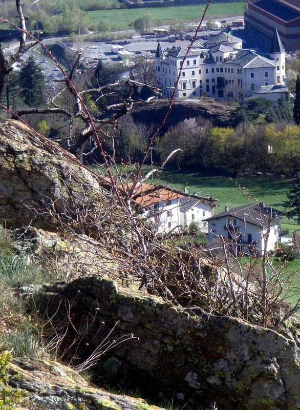
Questa piccola Sommità roccioso-boschiva si trava collocata subito a Nordest della Città di Aosta, tra questo Comune e quello adiacente di Saint Christophe. Questa, apparentemente poco importante, conosce invece un'elevata presenza di escursionisti durante tutta la settimana, che la fanno diventare sicuramente la Sommità più frequentata dell'intera Valle di Aosta. Inoltre questa Area Naturale dedicata dagli Scouts al loro fondatore Robert Baden-Powell conosce un'ottima affluenza in tutte le stagioni, compresa quella invernale. Gli stessi hanno ribattezzato questa zona, conosciuta in loco come "Lo Tsateli o Tsatelet", ovvero il Castelletto, oppure Area dello Châtelair, forse per le presenze dei viciniori Castelli "Barone Passerin d'Entrèves" e "Duca degli Abruzzi", dove é sita la rinomata Scuola Militare Alpina di Aosta. Appena più al di sotto tra Aosta-"Quartiere San Rocco" e la Frazione di Busseyaz esiste un'altra Area Naturale detta di Châtelair, subito ad Ovest della Scuola Militare Alpina ed appena al di sotto d'un antico e circolare Tumulo Celtico, dove pare sia sepolto un Principe dei Salassi. Ma la cosa é ancora tutta da dimostrare, mentre proseguono gli studi degli Archeologi. Comunque tutta una zona educativo-istruttiva per i Ragazzi, dove spesso ho accompagnato quelli della mia Scuola portandoli sù fino a Quota B.P. Da qui si "domina" la Valle, la Città d'Aosta con il suo circondario di montagne ed anche il "Castello della S.M.A" oppure "Castello Jocteau", con la palestra di roccia (vedi foto sotto ed al soprastante "Sasso Marconi" col climber aostano Bastia), ove hanno arrampicato tanti scalatori famosi durante il servizio militare. Ma spesso é stata anche occasione per spiegare agli stessi chi fosse l'inglese Sir Robert Stephenson Smyth Lord Robert Baden-Powell, dando significato a quella sigla B.P. fino ad allora rimasta sconosciuta ai medesimi e spesso confusa con una marca di benzina o qualche astrusa formula chimico-fisica (per alcuni addirittura le iniziali di una setta demoniaca segreta). Un dubbio dipanato pei ragazzi che spesso volan di Fantasia. Ma neppur troppo ché qui pochi anni orsono v'era stata indagine delle Forze dell'ordine a seguito del ritrovamento di teste d'animali completamente mozzate ...
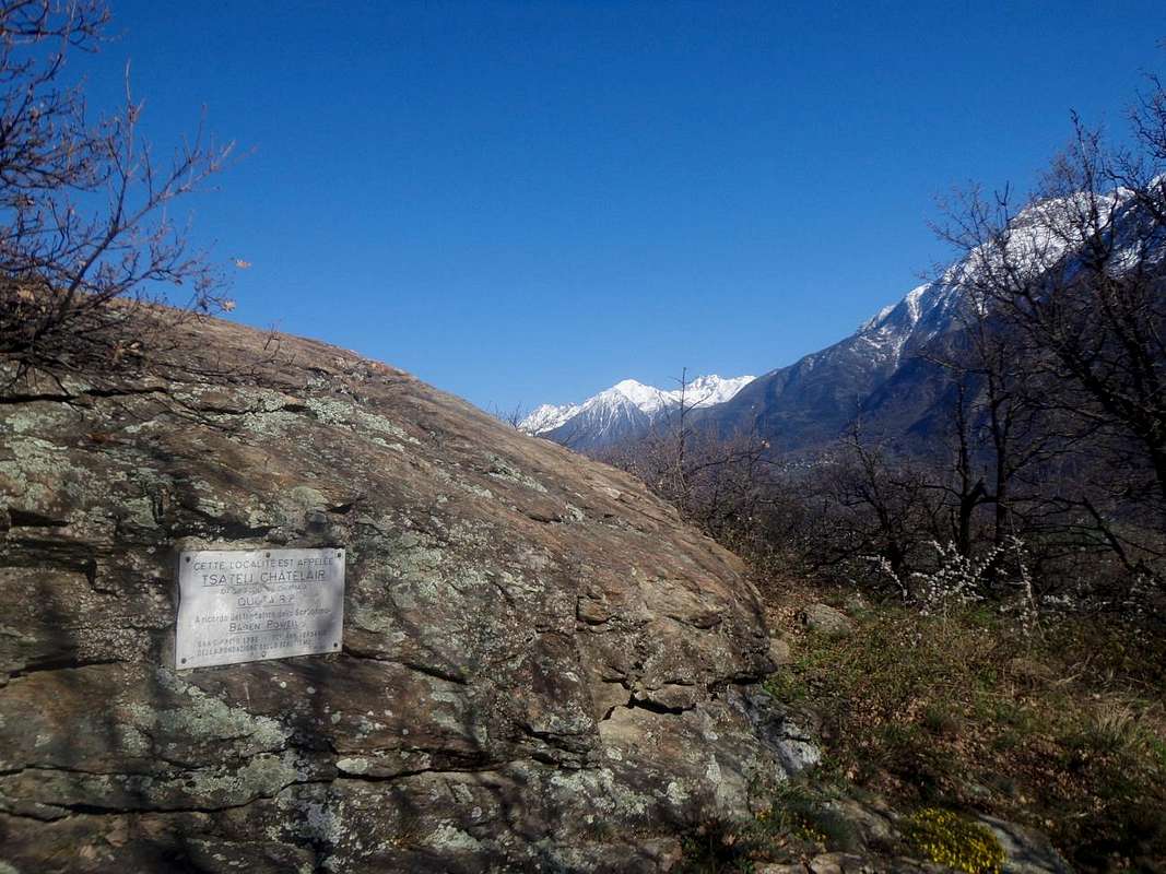
"Carneades, but who was he?" From Wikipedia: "Robert Baden-Powell, full title of Sir Robert Stephenson Smyth Baden-Powell Lord, First Baron Baden-Powell of Gilwell (['beɪdən' pəʊəl]; London, 22 February 1857 - Nyeri , January 8, 1941), was a general educator and writer, best known for being the founder, in 1907, the world Scout movement and soon after that of Guiding. Through the merits granted to him regarding the foundation of the Scout Movement, they were conferred the titles of Baronet and Lord. The scouts and guides call it simply BP (as he used to shorten his signature). The day of his birth is celebrated by the name of Thinking Day (Day of Thought)." This area, which as we have already said, is known as "The Tsateli or Châtelair" is called since 1993, the year that has been trumpeted as a Natural Protected Area, "Area Tsatelet". It covers an area of 14 hectares (ha) and has been divided into six zones by Naturalists diversified. His Flora is varied, while the territory is associated with the type pseudo steppe; also it seems to include some remains of the Neolithic, which was not yet fully investigated. For the general population, however, the name is more usual to "Quota BP", as well as have christened the Boy Scouts & Guides placing a commemorative plaque to mark the 75th anniversary of the founding of the "Scouting" (1907). After the great success at the first in its Homeland, then international and still later in the world, a few years later wrote "Aids to Scouting" for younger and founded, under the coordination of Sister Agnes, the women's movement of the "Guiding", not wanting to accept the admission of these in the men field. A Precursor of maschilism? Another plaque, not far towards the West, was dedicated July 2th, 1978 by the "Alpini" (Italian Alpine Troops), homonymous 1st Day, the "Lady of the Snows".
"Carneade, ma chi era costui?" Da Wikipedia: "Robert Baden-Powell, titolo completo Sir Robert Stephenson Smyth Lord Baden-Powell, Primo Barone Baden-Powell di Gilwell (['beɪdən 'pəʊəl]; Londra, 22 febbraio 1857 – Nyeri, 8 gennaio 1941), è stato un generale, educatore e scrittore inglese, noto soprattutto per essere stato il fondatore, nel 1907, del movimento mondiale dello scautismo e subito dopo di quello del guidismo. Per i meriti riconosciutigli in ordine alla fondazione del movimento scout, gli furono conferiti i titoli di Baronetto e di Lord. Gli scout e le guide lo chiamano più semplicemente B.-P. (come soleva abbreviare la sua firma). Il giorno della sua nascita è festeggiato col nome di Thinking Day (Giornata del Pensiero)." Quest'Area, come abbiam già detto, é conosciuta come "Lo Tsateli or Châtelair" viene chiamata dal 1993, anno in cui é stata declamata come Area Naturale Protetta, "Area Tsatelet". Ricopre una superficie di 14 ettari (ha) ed é stata suddivisa dai Naturalisti in sei zone diversificate. La sua Flora risulta varia, mentre il territorio viene associato alla tipologia pseudo steppica; inoltre sembra che comprenda alcuni resti del Neolitico, peraltro non ancora indagati completamente. Per tutti però il toponimo più usuale é quello di "Quota B.P.", così come l'han battezzata Boys Scouts e Guide apponendo targa commemorativa in occasione del 75° Anniversario della fondazione dello "Scoutismo" (1907). Dopo il grande successo riscosso dapprima in Patria e poi internazionalmente diffuso in tutto il mondo, pochi anni appresso scrisse per i più giovani "Aids to Scouting" e, non volendo accettare l'intromissione femminile in questa associazione, fondò il parellelo movimento delle "Guide" dedicato alle ragazze. Un altra targa, non molto distante e più verso Ovest, è stata dedicata il 2 luglio 1978 dagli Alpini della Valle di Aosta, nell'omonima 1° Giornata, alla "Madonna delle Nevi".

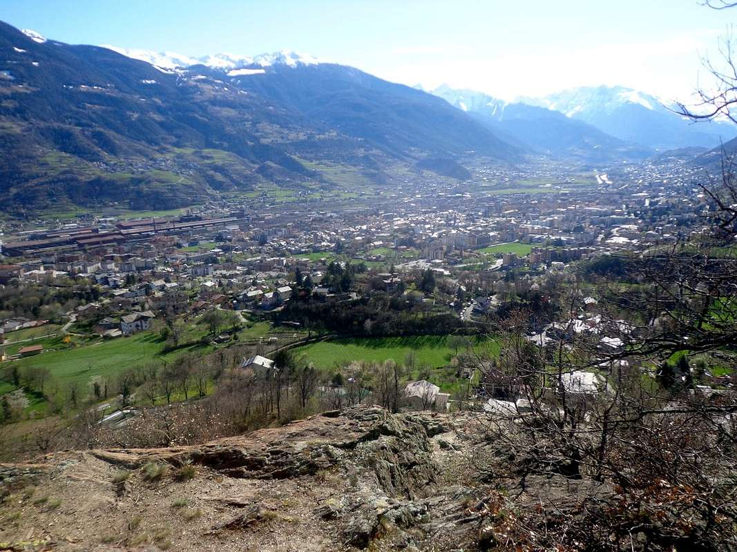
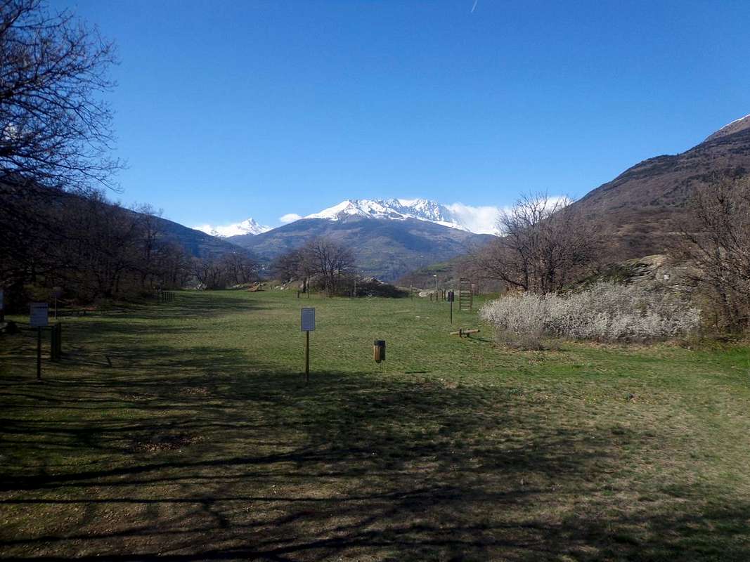
A nice Walk, a small Excursion chase away the bad Ghosts from the mind of Youth. Contact outdoors with Nature promotes positive thoughts and not just for the boys. Dues B.P. it offers room for all: the children who provides milestones equipped for children's games, the boys with a football field and a gym with the basic tools in the wide plateau between the two Summit, to men and women with small walks to regenerate body and spirit, to the elderly for short journeys seconded by wooden benches scattered here and there, someone to bring animals for a ride, for education and dispute Orienteering races ... and also to climbers going to train the boulder "Sasso Marconi", a rock much more popular for training than you may think. All admiring northward chain Becca Viou/Tsaat a l'Etsena/Croix de Fana to that of Grand Combin and Mont Velan up to the Great St Bernard Pass in By Basin, West on the Mont Fallère Group, South to the entire Graian Alps including the Group of Mont Paramont, that of Testa of Rutor, Becca di Tos, Punta Bioula and Punta del Ran at the entrance of La Thuile, Valgrisanche, Rhemes, Savarenche and Cogne in parallel Valleys, "Becca" and Emilius, Rouèses Chain over Pollein and Grand Brissogne Municipalities, Mont Charmontane and Punta Nera above Fénis e Pontey Commons, Mounts Rouvìc & Avìc into the Mont Avìc Nature Regional Park and down the East Mont Zerbion above Châtillon-Saint Vincent Communes, the Dames de Challand and the Mont Néry or Becca Frudière at the beginning of Val d'Ayas. Always in freedom to move from side to side. And if you are of Tourists and looking for a little oasis for lunch interrupting a journey, not wrong: in a short time you reach Quota B.P. and you can refresh yourself in peace in his small protected woods, admiring a pano 360°, that makes it the envy of many more famous locations, but too far. You are all invited, without exception!

Una bella Passeggiata, una piccola Escursione scacciano i cattivi Fantasmi dalla mente della Gioventù. Il contatto all'aria aperta con la Natura favorisce pensieri positivi e non soltanto pei Ragazzi. Quota B.P. dà spazio a tutti: ai bambini ai quali offre delle tappe intermedie attrezzate per giochi infantili, ai ragazzi con un campo di calcio alla base ed una palestra con attrezzi nel largo pianoro tra le due Sommità, a uomini e donne per rigenerare con piccole passeggiate corpo e spirito, agli anziani per piccoli tragitti assecondati da panchine in legno disseminate qua e là, a qualcuno per portare gli animali a fare un giro, per l'istruzione e la disputa di gare di Orienteering ed ... anche agli arrampicatori andando ad allenarsi al "Sasso Marconi", un macigno molto più frequentato pegli allenamenti di quel che si pensi. Il tutto ammirando verso Nord la catena della Becca di Viou/Tsaat a l'Etsena/Croix de Fana a quella di Grand Combin e Mont Velan fino al Colle del Gran San Bernardo, ad Ovest sul Gruppo del Fallère, a Sud l'intere Alpi Graie compreso il Gruppo del Mont Paramont, quello del Rutor, Becca di Tos, Bioula e Punta del Ran all'ingresso delle parallele Valli di La Thuile, Valgrisanche, Rhemes, Savarenche e Cogne, "Becca" ed Emilius, Rouèses, Mont Charmontane Punta Nera sopra Fénis e Pontey, Rouvìc & Avìc ed a Oriente giù sin allo Zerbion, alle Dames de Challand ed al Mont Nèry. Sempre in libertà di muoversi da una parte all'altra. Se poi siete dei Turisti e cercate una piccola oasi per pranzare interrompendo un viaggio, non sbagliate: in breve tempo raggiungete Quota B.P. e potete ristorarvi in santa pace nei suoi boschetti protetti, ammirando un pano a 360° che fà invidia a molte località più famose, ma più lontane. Siete tutti invitati! Nessuno escluso!!

Getting There
BY CAR:
- From TORINO, MILANO, etc: Motorway A5. Exit at IVREA or Quincinetto (PIEDMONT).
- From IVREA Town: in West to Aosta, after in Northeast to Saint Christophe Municipality. From Courmayeur Resort: before in East to Aosta, after in Northeast to Saint Christophe Municipality.
- Specific Roads From Aosta city, reached with the SS.26, continue in North-northeast towards Senin (nearby Thovex or Theuvex small Hamlet), in North Busseyaz Village through the Regional or Municipal Roads or in North-northwest towards Roppoz, Morisod, Arsin, Papet, Chapelle Hamlets and Porossan Fraction with the Main Road.
- From FRANCE: through the Mont Blanc Tunnel to Entrèves-crossroads to Vény/Ferret Valleys - Mountain Guides of Courmayeur - La Saxe Rock Gym - Courmayeur. By Little Saint Bernard Pass, closed since November until half May to La Thuile Valley - Pré Saint Didier - Courmayeur. It is not necessary to take Motorway A5: you can drive on SS.26, in the direction of AOSTA - IVREA - TURIN.
Some little itinerary
Give some brief indications on paths, clockwise starting from the North, to reach Quota B.P. The main entrance is located on the Regional Road that connect them Fractions Senin-Thovex (791m, 766m, Municipality of St. Christophe) and Nayves-Porossan (754m, 723m, Aosta); the same, coming from St. Christophe (East) that connects the Central Valley of Dora Baltea with that of the Gran San Bernardo-Valpelline, reaching the Common of Roisan (843m). At the junction 730 meters, previous Thovex or Theuvex, leave this road turning suddenly to the West: a long diagonal pass near some farms leads to the last at a small votive Chapel (746m) and just before a water suspended above the road, beyond which ends the Municipality of St. Chtistophe and begins to Aosta with a locality called Chiou. Immediately after the parking is on the ground with illustrative panels (for the whole Tsatelet Area and even for the "Via Francigena" and the "Route des Vignobles or Via the Vineyards"), as well as the entrance to the base portion of the B.-P. leading to a football field, next to the above wood with stunning views towards Becca di Viou, Grand Combins Valsorey and Grafeneire and Mont Velan. From here begins the paths that reach Quote B.-P. from the North (parking) towards the Northeast (votive Chapel), South (Busseyaz) and West (Porossan).
Itinerary A) - from North: from the house of custody at the football field (here comes from the West also the path that goes from Porossan-Chapelle, Fraction of Aosta) come up with two options:
1) - take a steep branch that leads to the right (South-southwest) with some steep hairpin bends at a rock band with moss before the Hilltop North; exceeded the same with a little staircase on the rocks you reach the same.
2) - take the trail to the left (East), which reached a mini playground for children, rooms with a steep shortcut reaching a second in a small plateau; to continue this footpath and more pronounced, rising just above the boulder "Sasso Marconi" (where it is easy to see climbers in training), you reach the Northern Summit, where an explanatory in metal plaque is affixed to the rock and just at the beginning of the long plateau equipped as a sports gym.
Itinerary B) - from Northeast: from the votive Chapel before the aqueduct go up along the path bordered by a double wooden fence coming alongside the farm higher; here the same turn right (Southwest) and entering into the forest reaches the previous away at the plateau of the second playground. With the same conclude to the Summit.
Itinerary C) - from South: from the National Road at the "Roman Bridge", continue for a short distance to the Northeast towards the "Beauregard", and then take the left turn towards "Villa Chicco", which is given to the right to go up instead with an old mule track, now in asphalt, that with steep hairpin bends and reaches in succession the Area Châtelair, the Alpine Military School, the "Mound Celtic" and the small Fraction of Busseyaz (664m, at the foot of Quota B.P.). Here comes from the West is also a road with asphalt from Roppoz (562m). From Busseyaz a carriageway up towards North and follow it to the junction 684 meters, where it comes another from Morisod. Leave right (East) branch that continues to Lou or Loups (675/7m) and the nearby "Castle Passerin d'Entrèves" (unless you want to enlarge the tour and then connect with the routes from North) and take instead a small unnumbered path that climbs into the dense forest to then turn to the right under a series of rocky plates reddish; the cross easily but cautiously and with the upper part, and consists of steep switchbacks, you reach the Southern Summit. A short descent leads to the plateau with fully equipped gym and the Northern Summit. This route takes about 0h'45/10'00 from "Roman Bridge" and 0h'30 by Busseyaz; those in the North about 0h'25 from the parking lot or votive Chapel.
Itinerary D) - from West: starting with the most important Fraction of Porossan-Chapelle (710m) or from the tiny below Villages of Papet, Arsin and Morisod or to start with the small Municipal Roads and then through a little not numbered path go up Eastward into the woods to reach the soccer field, whence the previous Route A (0h'30).
Diamo qualche breve indicazione sui sentieri, in senso orario e partendo da Settentrione, per raggiungere Quota B.P. L'ingresso principale é situato sulla Strada Regionale che unisce le Frazioni di Senin-Thovex (791 m, 766 m; Comune di St. Christophe) ad Est e Nayves-Porossan (754 m, 723 m; Aosta) a Nordovest. La stessa, arrivando da St. Christophe (Est) collega la Valle Centrale della Dora Baltea con quella del Gran San Bernardo e la Valpelline, raggiungendo il Comune di Roisan (843 m). Giunti al bivio 730 metri, precedente il Villaggetto di Thovex o Theuvex, abbandonarla svoltando improvvisamente ad Ovest: un lungo diagonale passante vicino ad alcune fattorie sul ciglio della medesima conduce all'ultima presso una Cappelletta votiva (746 m) e subito prima d'un acquedotto in cemento sospeso sulla strada, oltre il quale termina il Comune di St. Chtistophe ed inizia quello di Aosta con la località di Chiou. Subito dopo lo stesso si trova un parcheggio in terra battuta con pannelli illustrativi (dell'intera Area Tsatelet ed anche della "Via Francigena" e della "Route des Vignobles o dei Vigneti"), nonché l'ingresso principale alla base della Quota B.P. che conduce ad un campo di calcio, al limite del bosco con splendida vista sulla soprastante Becca di Viou ed a Nordovest in direzione dei più lontani Grand Combins de Valsorey e Grafeneire e del Mont Velan. Da qui si dipartono a raggiera i sentieri per Quota B.-P. da Settentrione (parcheggio) verso il Nordest (Cappella votiva), il Sud (Busseyaz) e l'Ovest (Porossan).
Itinerario A) - da Nord: dalla casa di custodia presso il campo di calcio (qui arriva da Ovest anche il sentiero che sale da Porossan) salire con due possibilità:
1) - prendere una ripida diramazione verso destra che conduce con alcuni tornanti presso una fascia rocciosa con muschio precedente la Sommità Nord; superata la medesima con una piccola scalinata sulle rocce si raggiunge la medesima.
2) - prendere il sentiero verso sinistra (Est), che, raggiunto un mini parco giochi per bambini, sale con una ripida scorciatoia raggiungendo un secondo in un piccolo pianoro; da questo continuare tramite sentiero più marcato e, passando appena sopra il "Sasso Marconi" (dove é facile vedere degli arrampicatori in allenamento), si raggiunge la Sommità dove è affissa alla roccia una placca esplicativa in metallo, proprio all'inizio del lungo pianoro attrezzato a palestra sportiva.
Itinerario B) - da Nordest: dalla Cappella votiva prima dell'acquedotto salire lungo il sentiero delimitato da doppia staccionata in legno arrivando a fianco della fattoria di sopra; qui il medesimo piega a destra (Sudovest) ed entrando nel bosco raggiunge la precedente via presso il pianoro del secondo parco giochi. Con lo stesso concludere alla Sommità.
Itinerario C) - da Sud: dalla Strada Statale presso il "Ponte Romano" si prosegue per breve tratto a Nordest verso il "Beauregard", per poi prendere la deviazione a sinistra verso "Villa Chicco", che s'abbandona per salire invece a destra con un'antica mulattiera, ora in asfalto; con ripidi e stretti tornanti raggiunge in successione l'Area Châtelair, la Scuola Militare Alpina, il "Tumulo Celtico" e la Frazioncina di Busseyaz (664 m, proprio alle pendici di Quota B.P.). Qui giunge da Ovest anche una strada in asfalto con partenza da Roppoz (562 m). Da Busseyaz una carraia sale verso Nord e la si segue fino al bivio 684 m, ove ne arriva un'altra da Morisod. Lasciare a destra (Est) il ramo che continua verso Lou o Loups (675/7 m) ed il vicino "Castello Passerin d'Entrèves" (a men che non si voglia allargare il giro e poi collegarsi cogli itinerari da Nord) e prendere invece un sentierino non numerato, che sale dentro il fitto bosco per poi piegare a destra sotto una serie di placche rocciose rossastre; le si attraversa facilmente ma con cautela e con il tratto superiore, ripido e formato da stretti tornanti, si raggiunge la Sommità Meridionale. Una discesina conduce al pianoro con palestra attrezzata ed alla Sommità Settentrionale. Quest'itinerario richiede circa 0h'45/10'00 dal "Ponte Romano" e 0h'30 da Busseyaz; quelli a Nord circa 0h'25 dal parcheggio o dalla vicina Cappella votiva.
Itinerario D) - da Ovest: partendo dalla più importante Frazione di Porossan-Chapelle (710 m), oppure dai piccoli sottostanti Villaggi di Papet, Arsin o Morisod all'inizio con piccole Strade Municipali e poi con un sentierucolo non numerato si sale verso Est nel bosco raggiungendo il campo di calcio, donde con il precedente Itinerario A (0h'30).