
|
|
Mountain/Rock |
|---|---|
|
|
38.90931°N / 107.10009°W |
|
|
Download GPX » View Route on Map |
|
|
Gunnison |
|
|
Hiking |
|
|
Spring |
|
|
12212 ft / 3722 m |
|
|
Overview
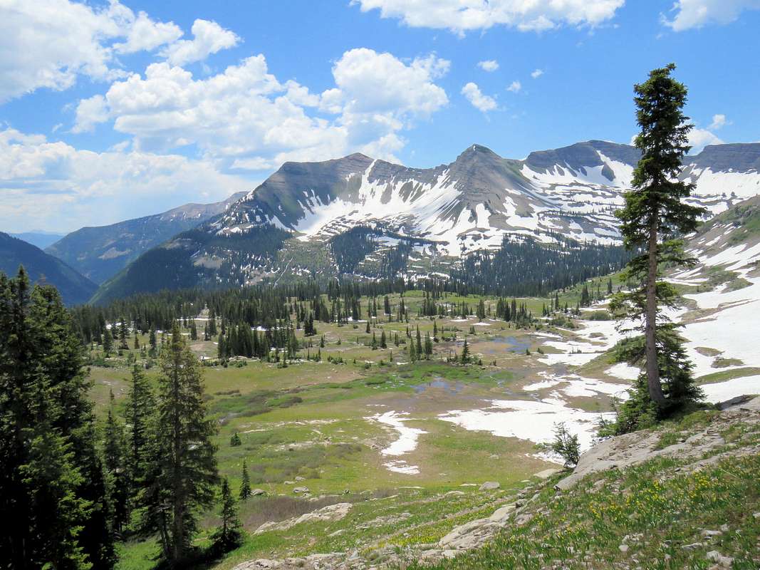
Right to Left: Scarp Ridge Summit, Garfield Peak and Peeler Peak, north faces from Democrat Basin
Scarp Ridge is a four mile long ridgeline that rises to the north of Lake Irwin in the Elk Mountains of central Colorado near the town of Crested Butte. The high point of this ridgeline is Colorado’s 1193rd highest ranked peak.
The southern slopes of Scarp Ridge are gentle and rise above Lake Irwin. The northern slopes create walls that drop into Oh-Be-Joyful and Peeler Basins. A trail starts to the north of Lake Irwin and goes up to the high point of Scarp Ridge. This short two mile long trail gives you a big bang for your relatively low effort. The views of the surrounding jagged peaks from the top of the high point are spectacular.
From the high point, which sits near the western end of the ridgeline, you could follow the ridgetop past many ups and downs to reach the 12090 Gunsight Pass to the west of Mount Emmons. I went halfway to the top of Point 12092 ft. For the descent, I found a different trail that took me down the slopes to the east of the trail that took me up (see map below).
Getting There
From the junction of Route 135 and Whiterock Ave in Crested Butte, turn west onto Whiterock Ave and drive a few blocks to the end of town where the road becomes Kebler Pass Road (route 12). Drive this road (partly paved, partly well graded dirt) less than 6 miles to just before Kebler Pass and turn north onto a signed dirt road to Lake Irwin (Road 826). Drive this road (passable by most cars under normal conditions) roughly 2 miles to Lake Irwin. Beyond the lake you may see unsigned branches, see map below. Continue to the north side of the lake and turn east onto a road that goes down to cross the river over a bridge and then switchbacks up to end at the abandoned Lake Irwin Lodge where you can park. The last piece where the road crosses the river is much rougher. I drove an SUV but saw a Mercedes Benz sedan at the trailhead .Route
Main Trail to summit:Trailhead Elevation: 10660 ft
Summit Elevation: 12212 ft
One Way Hiking Distance: 2.0 miles
Find Scarp Ridge Trail on the north side of the abandoned Lake Irwin Lodge.
 Abandoned Lake Irwin Lodge
Follow the trail uphill in a beautiful prairie with good views of the mountains to the south and west. At around 11000 ft an unsigned trail branches to the east as shown on the above map. Continue straight.
 Ruby Peak Ruby Peak |
 Anthracite Ridge Anthracite Ridge |
 Beckwith Mountains Beckwith Mountains |
 Ruby, Owen, Afley Peaks Ruby, Owen, Afley Peaks |
The summit of Scarp Ridge will come to view.
 Summit
Views from the summit.
 Afley & Purple Peaks Afley & Purple Peaks |
 Ruby, Owen, Purple Peaks Ruby, Owen, Purple Peaks |
 Anthracite Range Anthracite Range |
 Oh-Be-Joyful/Democrat Basin Oh-Be-Joyful/Democrat Basin |
Hiking along the crest of Scarp Ridge:
Scarp Ridge from the summit.
 Ridge to Mt. Emmons
Lake Irwin and the Anthracite Range.
 Lake Irwin & Anthracite Range
A beaten path may be visible along the crest of the ridgeline. In a few places, forests came up the southern slopes to the edge of the ridgetop requiring minimal bushwhacking.
 |
 |
On the way to Point 12092 ft.
 |
 Ruby, Owen, Purple Peaks Ruby, Owen, Purple Peaks |
From the top of Point 12092 ft. Peeler Lakes and Basin seen.
 Peeler Lakes and Scarp Ridge Peeler Lakes and Scarp Ridge |
 Upper Peeler Basin, Owen, Afley Peaks Upper Peeler Basin, Owen, Afley Peaks |
 Mt. Snowmass & Maroon Bells Mt. Snowmass & Maroon Bells |
 Gothic Mountain Gothic Mountain |
 Mt. Axtell, Carbon Peak & Scarp Ridge
East Trail:
This trail branches off of the main trail at an unsigned, nonspecific area and goes to the top of the ridge as shown on the above map. It can be used as an alternate/return path.
 Anthracite Range Anthracite Range |
 Beckwith Mountains Beckwith Mountains |