
-
 6453 Hits
-
 83.1% Score
-
 16 Votes
|
|
Mountain/Rock |
|---|---|
|
|
46.08437°N / 7.70511°E |
|
|
Mountaineering, Trad Climbing |
|
|
Summer |
|
|
13041 ft / 3975 m |
|
|
Overview
 Schalihorn, the forgotten summit in front of Walliser Weißhorn
An interesting phenomenon is that of the “forgotten summits”. Those summits are not in the common interest of mountaineering for special reasons. In the case of the Valais area this means:
those summits are below the “magic line” of 4000 m
This is the case e.g. for Fletschhorn (3994 m) and Lagginhorn (4010 m). Whereas the Lagginhorn normal route is in my opinion rather boring but, leading up to a summit beyond the magic line, very crowded, the Fletschhorn ascent and traverse is an interesting and lonely undertaking.
Another example is Blanc de Moming with the Arete du Blanc – Route. Located between Dent Blanche, Obergabelhorn, Zinalrothorn and Weißhorn, Blanc de Moming is unknown to most mountaineers. The Arete du Blanc is a very nice snow arête like the famous Biancograt to Piz Bernina but Blanc de Moming is only 3663 m high.
In the area of Rothornhütte the best example for a forgotten summit is Schalihorn. This 3975 m high peak lack 25 m for the magic line. This is why nearly nobody is interested in climbing Schalihorn. The summit nevertheless receives some visits throughout the year: people who want to climb Walliser Weißhorn via Schaligrat have to traverse Schalihorn to reach Schalibiwak, the bivvy shelter at the foot of Schaligrat and the only access possibility for Schaligrat. An obstacle for those mountaineers is Schalihorn. For me it was the sole target on one day of our 2016 Valais weeks.
 Schalihorn between Zinalrothorn and Waliser Weißhorn Schalihorn between Zinalrothorn and Waliser Weißhorn |  Schalihorn (right) and Pointes de Moming as seen from Mettelhorn Schalihorn (right) and Pointes de Moming as seen from Mettelhorn |
Schalihorn is the most interesting peak within the connecting ridge between Zinalrothorn to the south and Weißhorn to the north. This huge glaciated ridge divides Mattertal to the east from Val d´Anniviers to the west. East and south of the summit stretches Schaligletscher, west of it Glacier de Moming and northwest Weißhorngletscher. Schalihorn itself has a glaciated south side whereas the west and east faces are steep rock faces.
The summit zone is built up of the higher south summit (3975 m) and the slightly lower north peak (3955) which drops down to the 3786 m high Schalijoch with its bivvy shelter. The summit arête and the north arête to Schalijoch consist of rather unstable and frail rock, mostly covered with ice and snow.
The south ascent to Schalihorn, the normal route, is a rather easy, interesting and – in my opinion – beautiful alpine tour. I don´t complain about meeting no people during this tour but: after summiting I really do not quite understand why Schalihorn is a forgotten summit.
Getting There
Trailhead for Schalihorn is Rothornhütte, the famous starting point for Zinalrothorn and Obergabelhorn / Wellenkuppe.You reach Rothornhütte from the town of Zermatt.
 Rothornhütte Rothornhütte |  Zermatt as seen from Edelweiß inn Zermatt as seen from Edelweiß inn |
Follow Bahnhofstraße from the train station in southern direction. Take the first road branching off to the right after Hotel Mont Cervin Palace, called “Chrum”. Turn left on Triftweg, leave Zermatt, continue on a good trail along Triftbach and pass by Edelweißhütte, further up the private mountain hut “Hotel du Trift” (2340 m).
Follow the signposts up to Rothornhütte (3195 m).
Normal Routes Overview
Schalihorn Routes Overview
Normal south route
Take the first breakfast with all the Zinalrothorn aspirants. From the huts terrace go south upward below Eseltschuggen, the rock ridge above the hut, and enter Rothorngletscher. Follow the glacier up in northeastern direction; at about 3400 m the glacier track to Zinalrothorn turns left; go straight on there.
 Morning skies over Mischabel group Morning skies over Mischabel group |  Unter Äschhorn Unter Äschhorn |  Ridge to Ober Äschhorn Ridge to Ober Äschhorn |
At a height of about 3550 m you arrive at the glacier col between Unter Äschhorn and Ober Äschhorn. Turn left to the lowest rocks of the east ridge up to Ober Äschhorn. The first part of the ridge are steep slabs (grade II) which can be climbed directly along the sharp ridge crest or right of it. There is a sling at the end of the slabs for abseiling.
 The crux slabs at Ober Äschhorn The crux slabs at Ober Äschhorn |  Climbing the Ober Äschhorn ridge Climbing the Ober Äschhorn ridge |  Ober Äschhorn summit Ober Äschhorn summit |
After that follow the east ridge with nice talus scrambling to the summit of Ober Äschhorn (3669 m). Follow the west ridge over more talus (easy) down to the glaciated col between Ober Äschhorn and Zinalrothorn (Ober Äschjoch). Turn north there and descend the Schaligletscher to the broad upper glacier basin of Schaligletscher (3400 m), traverse the basin to its north end and ascend the steep, heavily crevassed north part of Schaligletscher. We found it better to first keep more right / east and then turn more left / west; this depends on the actual condition of this crevassed part. Be aware of some seracs looming near the Pointes de Moming above the ascent route!
 Traversing Schali glacier basin Traversing Schali glacier basin |  Ascending to Hohlichtpass Ascending to Hohlichtpass |  Ascending to Hohlichtpass Ascending to Hohlichtpass |
At about 3600 m the grade of the slope gets more moderate; go north and nothnorthwest to reach a col between Schalihorn to the north and Pointe Nord de Moming to the south, the so called Hohlichtpass (3731m).
 Hohlichtpass Hohlichtpass |  Schalihorn south slope Schalihorn south slope |  Almost at the summit Almost at the summit |
From Hohlichtpass follow the south ridge on steepening snow and ice up to the short rock part of the summit block. Navigate around or ober some rocky steps (short grade I and II – moves) to the south summit.
Traverse to Schalibiwak
The traverse of Schalihorn to Schalijochbiwak is rated ZS+ / AD+, grade III / IV in sometimes bad rock. This part is necessary to gain the starting point for Schaligrat to Walliser Weißhorn. It seems to be a sort of test: those who have no difficulties with Schalihorn traverse will have no difficulties with Schaligrat to Weißhorn either.
This page offers a very good description (in german) and good fotos of the traverse. I tried to translate the important parts of the description.
 Wellenkuppe, Obergabelhorn from Ober Äschhorn Wellenkuppe, Obergabelhorn from Ober Äschhorn |  View from Hohlichtpass View from Hohlichtpass |  Schalihorn between Zinalrothorn, Weißhorn as seen from Allalinhorn Schalihorn between Zinalrothorn, Weißhorn as seen from Allalinhorn |
"Follow the ridge crest for some meters, then descend righthand below the ridge crest and traverse the steep slope with loose rock (grade II) to a steep tower. Overcome this tower (grade III) and follow again the ridge crest with some bypassing on the east side until you arrive at the north summit of Schalihorn.
About 1 hour with good conditions, longer with snow and ice!.
Descend from there on good rock to a huge tower (ridge gendarme). There are bypass – possibilities on the west (grade III) or east (loose rock) side. Abseil about 25m to a huge boulder. Use some ledges with loose scree and talus to bypass another tower system (grade II).
 Ascending to Hohlichtpass Ascending to Hohlichtpass |  Äschhörner and Schali glacier Äschhörner and Schali glacier |
Follow the ridge until you arrive at a huge tower, called „Sphinx“. Climb the Sphinx (grade III) and abseil down this tower to an easy part of the ridge which leads to a system of black towers. Bypass them on their east side or choose some ledges on ist west side and return to the ridge crest to overcome the black towers (grade III good rock). A last abseil above a huge slab and an overhang leads into the east face of the ridge just below the ridge crest. Traverse then below the ridge crest around huge loose boulders back to the ridge and enter Schalijoch over easy rocks (or snow). Ascend in 5 minutes to the Schalibiwak.
3,5 hours with good conditions."
Red Tape & Accommodation
There are, as far as I know, no special restrictions in this area.All parking areas require fees.
You find Hotels, Bed & Breakfast, Tourist houses and campgrounds in and around
 Ascending to Rothornhütte Ascending to Rothornhütte |  Schalihorn between Zinalrothorn and Weißhorn Schalihorn between Zinalrothorn and Weißhorn |
Mountain huts for the summits are
Gear & Mountain Condition
Schalihorn south summit is a summer alpine glacier tour from Rothornhütte. It requires climbing abilities up to grade II at the ridge to Ober Äschhorn and at the summit block, in addition some experience with glaciers.You need as glacier gear a rope, harness, some carabiners and slings and ice screws. Crampons and an ice axe are mandatory.
I would rate the Schalihorn south summit as PD+
For the traverse to Schalibiwak you need additional climbing gear and the ability to climb grade III rocks with crampons (if the snow and ice situation requires that). Don´t underestimate that part.
It is commonly rated AD+.
 Schalihorn and the ridge to Schalijoch as seen from Weißhorn east ridge Schalihorn and the ridge to Schalijoch as seen from Weißhorn east ridge |  Small Schalihorn as seen from Weißhorn summit Small Schalihorn as seen from Weißhorn summit |
Current Weather:
Zermatt village
Zermatt mountain
Maps & Guide Books
Map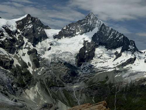 Schalihorn and Walliser Weißhorn Schalihorn and Walliser Weißhorn |  Schalihorn and Walliser Weißhorn Schalihorn and Walliser Weißhorn |
Guide Books
The main guidebooks, available in German, are
Postscript - 07.09.2016
Wow!I thought Schalihorn is a forgotten summit. But I´m wrong!
Some SP user attached many many great pics to this page.
It seems that Schalihorn inspires our community and is not forgotten among us. Thanks a lot.
Michael