
-
 6138 Hits
-
 86.85% Score
-
 23 Votes
|
|
Mountain/Rock |
|---|---|
|
|
45.79620°N / 7.37904°E |
|
|
Mountaineering |
|
|
9370 ft / 2856 m |
|
|
Overview
The Tête d'Arpisson, also known as "Pelon de Quart" grows up, like a round head from the ridge Monte Faroma – Becca di Viou, between the Colle di Chaudière and a sequence of unnamed summits to NE. The ridge is made by a lot of pinnacles, towers and gendarmes. From the summit a wonderful panorama.
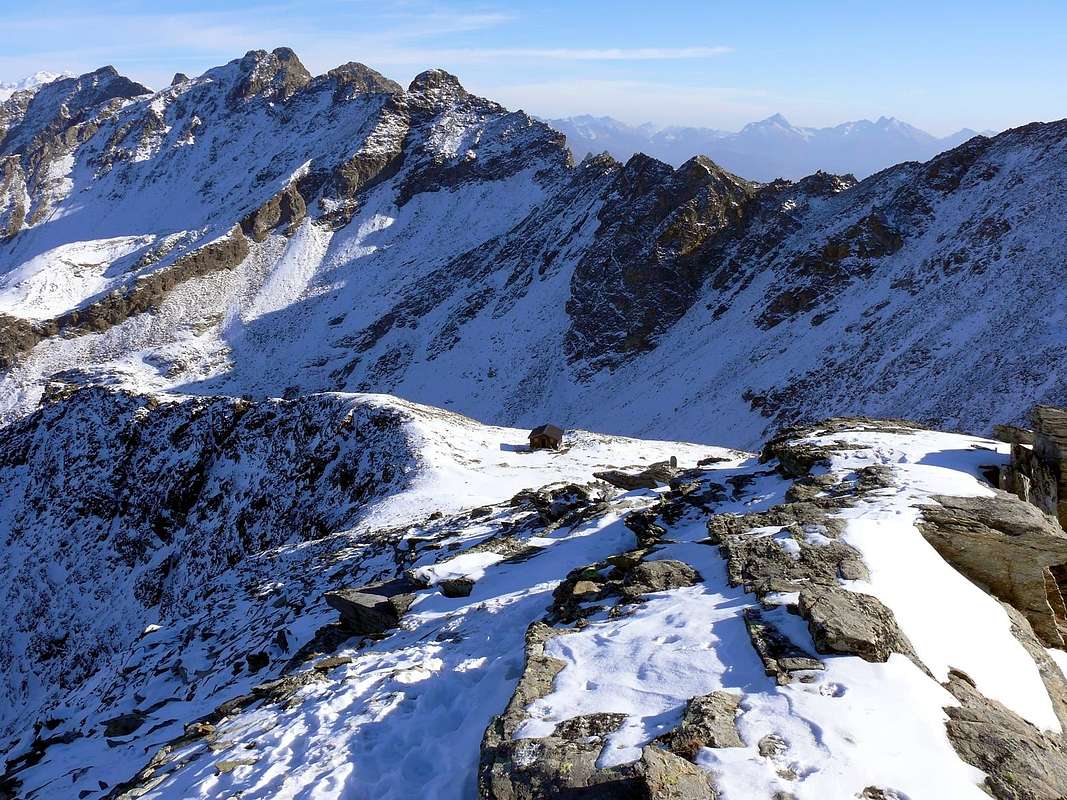
La Tête d'Arpisson, conosciuta anche come "Pelon de Quart", si eleva a guisa di testa arrotondata sulla Costiera Monte Faroma – Becca di Viou, tra il Colle di Chaudière a sud-ovest ed una serie di quote a nord-est. La cresta è costituita da innumerevoli spuntoncini, torrioni e gendarmi. La cima ha un notevole interesse panoramico.
First Ascents
- First Ascent (normal route from S-W Arête): abate Joseph Henry, (Aug 19th, 1905).
- First Winter (S-W Arête): Osvaldo Cardellina, Giuseppe Lamazzi and Marco Cossard, (Mar 02th, 1975).
Getting There
BY CAR:- From Torino, Milano, etc: Motorway A5. Exit at Aosta Est.
- From Switzerland: through the Grand Saint Bernard Tunnel or the namesake pass.
- From France: through Mont Blanc Tunnel or Petit Saint Bernard Pass. It isn't necessary to take Motorway A5: you can drive on SS.26, in the direction of Aosta.
BY PLANE:
- Aeroporto "Corrado Gex" Saint Christophe (Aosta).
Route

From Aosta Est toll of the highway toward Aosta and, just after the airport, turn to the right toward Saint Christophe (615m). Follow (take care) signs for Sorreley (790m). A litle before it turn to the left and, after passing the Village of Veynes (841m) and the Villages of Morgonaz (1.174m), and Prayon (1.280m) follow up to Chamerod (1.638m), (the route maybe closed in winter). Cross Chamerod along an ancient comfortable muletrack that, rounding to NE, leads to Alpe Les Preles (1.795m). Going on in the same direction, using a steep path, you get a further mountain pasture in the middle of a wood. Passing West of the fork to Alpe Chavod (2.020m), follow till the pastures beyond the Alpe di Senevé (2.196m) and get it. Form this pasture go NW on pastures and scree toward the Colle di Chamerod (2.700m), between Mont Mary (2.815m) and the two unnamed summits before Colle Chaudière (2.680m). Cross, scrambling, the two summits to get the narrow notch of Colle Chaudière, then along the SW ridge starting with some easy (I U.I.A.A.) stretches of rock and ending on scree to the summit.
All'uscita del Casello Autostradale di Aosta Est proseguire verso la Città di Aosta e, subito dopo aver superato l'Aeroporto Corrado Gex, svoltare a destra verso il Paese di Saint Christophe (615 m). Seguire attentamente i cartelli per la Frazione di Sorreley (790 m); poco prima di arrivarci svoltare sulla sinistra e proseguire verso il Villaggio di Veynes (841 m), (lasciato a sinistra il bivio per Blavy, cartello Montagne). Continuare a salire oltrepassando il Villaggio di Morgonaz (1.174 m) e il successivo di Prayon (1.280 m), dove al tornante seguente inizia la strada poderale con cartello di divieto; salire ancora sino a raggiungere Chamerod (1.638 m). Attraversarlo seguendo un'antica mulattiera che comodamente, con giro a nord-est, porta all'Alpe Les Preles (1.795 m); continuando nella stessa direzione, per un sentiero abbastanza ripido si raggiunge un'ulteriore alpeggio diroccato nel mezzo del bosco, oltre il quale, lasciando ad est la diramazione per l'Alpe Chavod (2.020 m), porta ai pascoli sottostanti l'Alpe di Senevé (2.196 m) che in breve si raggiunge. Dall'alpeggio puntare a nord-ovest su pascoli alternati a pietraie in direzione del Colle di Chamerod (2.700 m), tra il Mont Mary (2.815 m) e due elevazioni precedenti il Colle Chaudière (2.680 m). Superate le due elevazioni per roccette, si tocca lo stretto intaglio del Colle Chaudière e si prosegue integralmente sul filo della cresta Sud-Ovest, che all'inizio presenta qualche breve tratto arrampicabile (I° grado), per poi terminare su detriti fino alla vetta.
Equipment for the Route
Standard mountaineering equipment.Difficulty
Normal route - Easy anf for Experienced Hikers F+.Campings
Remember that free camping is forbidden (except for emergency reasons, over 2.500m, from darkness until dawn).

|

|
Mountain Condition
- Meteo: you can find all the needed informations at the official site of the Valle d'Aosta Region:
- Valle d'Aosta Meteo
Webcam
- WEBCAM on Aosta Valley:
- Webcam
Books and Maps
BOOKS:- "Guida della Valpelline" de l'Abbè Joseph-Marie Henry - Societè Editrice Valdotaine 1925 II Edition e Collana Reprint Musumeci (1986).
- "Guida dei Monti d'Italia-Alpi Pennine (Vol. 2)" di Gino Buscaini - Club Alpino Italiano/Turing Club Italiano, Luglio 1970 (in Italian).
- "80 itinerari di Escursionismo Alpinismo e Sci Alpinismo in Valle d'Aosta", di Osvaldo Cardellina, Ed. Musumeci, Giugno 1977 (in Italian); seconda Ed. Luglio 1981; terza Ed. Luglio 1984; (in French), prima Ed. Febbraio 1978; seconda Ed. Marzo 1980.
- "Dove andiamo in montagna? in Valle d'Aosta" di Domenico Caresio Edit. Tipografia Ferraro Ivrea, Marzo 1996.
- "Diari Alpinistici" di Osvaldo Cardellina e Indice Generale accompagnato da Schedario Relazioni Ascensioni 1964-2019 (unpublished).
 |
 |
- Kompass "Breuil/Cervinia-Zermatt-Carta turistica" 1:50.000.
- I.G.C. Istituto Geografico Centrale "La Valpelline" (carta n° 115) 1:30.000.
- I.G.M. Istituto Geografico Militare, Map 1:25.000.
- L'Escursionista Ed. Rimini "Gran San Bernardo-Ollomont" (carta n° 5) 1:25.000.
- Hapax "Les Sentiers", Luglio 2000 1:25.000.
Important Information
- REGIONE AUTONOMA VALLE D'AOSTA the official site.
- FONDAZIONE MONTAGNA SICURA Villa Cameron, località Villard de la Palud n° 1 Courmayeur (AO) Tel: 39 0165 897602 - Fax: 39 0165 897647.
- SOCIETA' DELLE GUIDE DELLA VALPELLINE Etroubles-Strada Nazionale, n° 13 - Tel +39 0165 78559 - Valpelline-Loc Capoluogo, n° 1 - Tel +39 0165 713502 (AO) Italia.
- A.I.NE.VA. (Associazione Interregionale Neve e Valanghe).
Useful numbers
- Protezione Civile Valdostana località Aeroporto n° 7/A Saint Christophe (Ao) Tel. O165-238222.
- Bollettino Valanghe Tel. 0165-776300.
- Bollettino Meteo Tel. 0165-44113.
- Unità Operativa di Soccorso Sanitario Tel. 118.