


-
 1824 Hits
-
 81.18% Score
-
 13 Votes
|
|
Mountain/Rock |
|---|---|
|
|
45.80180°N / 7.06663°E |
|
|
Aosta Valley |
|
|
Mountaineering |
|
|
Summer, Fall |
|
|
9137 ft / 2785 m |
|
|
Note
|
La montagna chiama i suoi figli, ed essi rispondono fedelmente al suo appello… Osvaldo Cardellina, Diario alpinistico, 1964-65 Page texts: @ OsvaldoCardellina "Osva", passed away on May 2, 2022. Page owners: Christian Cardellina e Osvaldo Cardellina. Any updates from September 12, 2022: Antonio Giani, page administrator, friend and climbing companion. Testi della pagina: @ OsvaldoCardellina "Osva", scomparso il 2 maggio 2022. Proprietari pagina: Christian Cardellina e Osvaldo Cardellina. Eventuali aggiornamenti dal 12 settembre 2022: Antonio Giani, amministratore della pagina, amico e compagno di salite. |
Overview
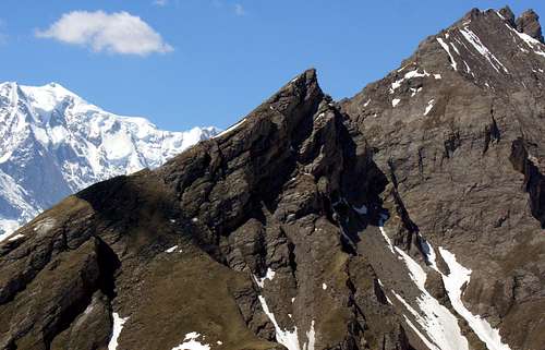
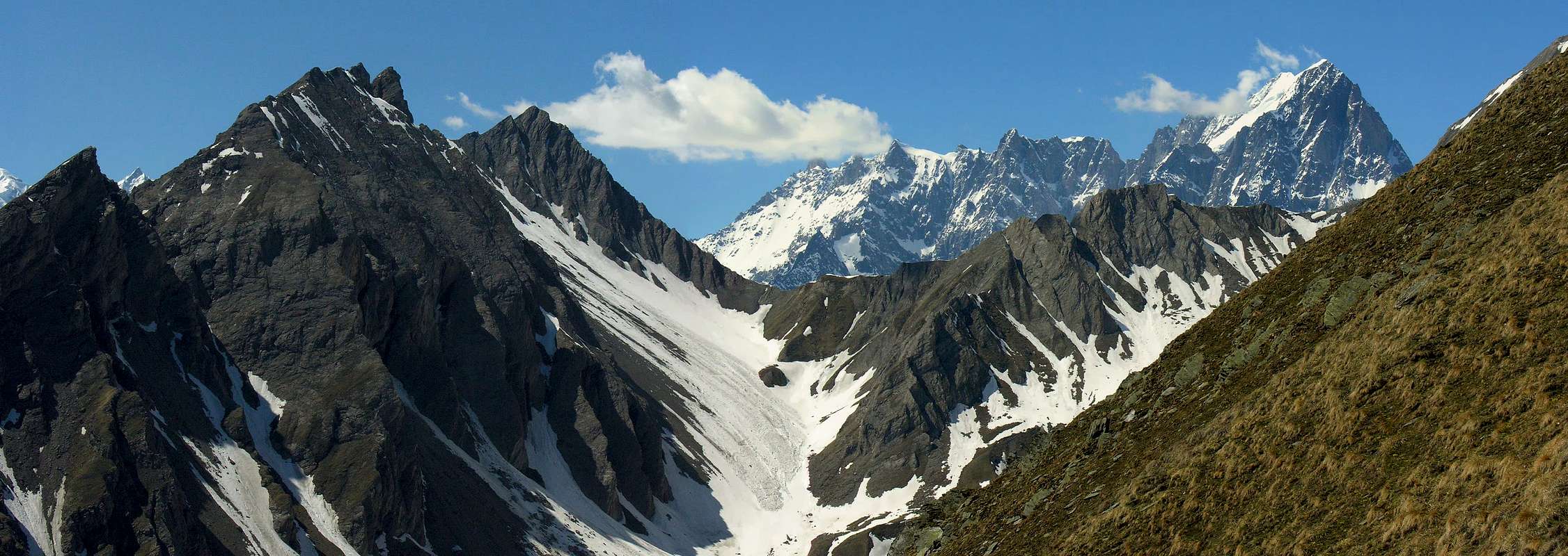
Small summit positioned almost at the end of the long South-southeast ridge of Grande Rochère (3.326m) called "de la Varise", which continuing from the Testa Nera ( Black Head) towards the North leads to the summit of Petite Rochère or Quota (altitude) 3.267 meters (See picture in bottom), as well as on the watershed between the Valloni di Chambave (to the west) and Planavalle (to East). It dominates this last basin just above the village of the same name (1.750m), leaving in Mezzogiorno another tiny Summit, namely the Bric or Bec Aoulié (2.532m) It is formed by two distinct summits of almost equal height (2.785, about 2.784 meters), of which the highest is the Southern one, that is the easiest. Poorly frequented also due to the steep grassy slopes at the base and above the built-up area of Planalle, it is reached almost exclusively by hunters. The crossing to the nearby Northern Summit is not difficult, but has a vertical and exposed passage. Beautiful views of the Mont Blanc range, as well as the nearby Grande Rochére (3.326m).
 |
 |
 |
Piccola sommità posizionata quasi al termine della lunga Cresta Sud-sudest della Grande Rochère (3.326 m) detta "de la Varise" (che continuando dalla testa Nera verso Nord conduce alla sommità della Petite Rochère o Quota 3.267 metri) (Vedi foto sotto) , nonché sullo spartiacque tra i Valloni di Chambave (ad Ovest) e di Planavalle (ad Est). Domina questo ultimo bacino proprio al di sopra dell'omonimo villaggio (1.750 m), lasciando a Mezzogiorno un'altra minuscola Sommità, ovvero il Bric o Bec Aoulié (2.532 m). Risulta formata da due distinte sommità di quasi uguale altezza (2.785, 2.784 circa metri), delle quali la più alta é quella Meridionale, ovvero la più facile. Scarsamente frequentata anche a causa dei ripidi pendii erbosi alla base e sopra l'abitato di Planalle, viene raggiunta quasi esclusivamente da cacciatori. La traversata alla vicina Sommità Settentrionale non è difficile, ma presenta un passaggio verticale ed esposto. Splendidi colpi d'occhio sulla Catena del Monte Bianco, nonché sulla vicina Grande Rochére (3.326m).
Getting There
Southeastern Getting There
BY CAR:
- From TORINO, MILANO, etc: Motorway A5. Exit at IVREA or Quincinetto (PIEDMONT).
- From IVREA Town: in West towards Pont Saint Martin, Donnas, Bard, Champdepraz, Pontey, Fénis, Saint Marcel, Grand Brissogne, Pollein, Charvensod, Gressan, Jovençan, Aymavilles, to Villeneuve, Arvier, Avise, Morgex and to Pré Saint Didier, Courmayeur Municipalities (Western side).
- From Courmayeur Resort: in East to Morgex, La Salle, Saint Pierre, Sarre, Aosta Municipalities.
Southern Side in Planavalle Torrent & Baltea Stream:
- From La Salle Common towards Planavalle Vallon From La Salle (1.001m), with Regional Road, towards Challancin (1.610m), Cheverel, Morges (1.829m), Planaval Hamlets (1.750m); from this, through farms dirt road in North-northeast, passing Maison Blanche Pasture, towards the Rantin (2.333m) and Bonalé (2.340m) Alpages, in Upper Planaval small Valley.
Route
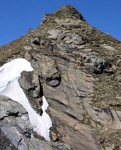
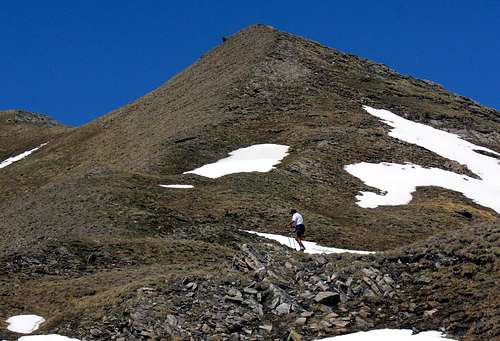
From the small Village of Planavalle (1.750m), comfortably parked the car at the restaurant, we descend briefly to the homonymous Torrent; then continue towards the North on the track of the private road-path towards Alpe les E'culés (1.880m), but without reaching it. Halfway, as well as leaving the detour to Alpe Rantin up and to the right or Northeast, one continues instead towards the West overcoming steep grassy slopes below the Bec or even Bric Aoulié (about 2.532/5 meters). which, after reaching the watershed with the adjacent Vallone di Chambave, double on the left (always towards the West). From this point a small track, discontinuous and often inconspicuous, goes up towards the North and, having discarded the same or Bec Aoulié to the right or East, it reaches the final slope consisting of small broken rocks mixed with grass. After having passed the two altitudes 2.682 and 2.742 meters about easily and staying on the left you will soon reach the Southern Summit, the highest (2.785m). Wanting to make also the crossing to the Northern Point or Summit, a short but exposed (10/12 meters; II°- / II°+) descent leads to a small carving and from this again without difficulty to the Cima Nord (Northern Summit), that result a little lower (F/F+; from 2h'30 to 3h'00 including the round trip to the North Summit).
IMPORTANT NOTE: Unexperienced hikers are advised not to cross the two summits.
 |
 |
 |
Dal Villaggio di Planavalle (1.750 m)., parcheggiata comodamente l'auto presso il ristorante, si scende brevemente all'omonimo Torrent; quindi si continua verso Settentrione sulla traccia della strada poderale-sentiero verso l'Alpe les E'culés (1.880m), ma senza raggiungerla. Bensì a metà strada, nonché lasciando in alto a destra o Nordest la deviazione per l'Alpe Rantin, si continua invece verso Occidente superando ripidi pendii prativi sotto il Bec o Bric Aoulié (2.532/5 metri circa). che, dopo aver raggiunto lo spartiacque con l'attiguo Vallone di Chambave, si doppia sulla sinistra (sempre verso Ovest). Da questo punto una piccola traccia, discontinua e spesso poco appariscente, risale verso Nord e, scartato a destra od Est il medesimo Bec, si raggiunge il pendio finale costituito da roccette rotte frammiste ad erba. Dopo aver oltrepassato le due quote 2.682 e 2.742 metri facilmente e restando sulla sinistra si raggiunge in breve tempo la Sommità Meridionale, la più elevata (2.785 m). Volendo effettuare anche la traversata alla Punta Settentrionale, una breve ma esposta (all'incirca 10/12 metri; II°-/II°+) discesa conduce ad un piccolo intaglio e da questo di nuovo senza difficoltà si raggiunge la Cima Nord di poco più bassa (F/F+; da 2h'30 a 3h'00 compresa la traversata andata e ritorno alla Sommità Nord).
NOTA: Si sconsiglia agli escursionisti di scarsa esperienza di effettuare la traversata tra le due Sommità.
 |
 |
 |
Difficulties & Equipment
This route can be considered E/F for the Southern Top, or EE/F+ (Experts Hikers) for the traverse towards Norther Summit; in winter (even by snowshoes or Ski).
L'itinerario è da classificare in E/F per la Cima Meridionale, oppure EE/F+ (Escursionisti Esperti) per la traversata a quella Settentrionale; in inverno (anche tramite Racchette da neve od in Scialpinismo).

Near the Southern Summit, by emilius
EQUIPMENT
Hiking gear, in winter as for Ski-Mountaineering or with Snowshoing.
Da Escursionismo, in inverno da Scialpinismo o con Racchette da neve.
Mountain Condition
- Meteo: you can find all the needed informations at the official site of the Valle d'Aosta Region:
- Valle d'Aosta Meteo
Books and Maps
- "Guida dei Monti d'Italia-Alpi Pennine" (Vol. I°) di Gino Buscaini-Club Alpino Italiano/Turing Club Italiano, Luglio 1971 (in Italian).
- "Diari Alpinistici" di Osvaldo Cardellina e Indice Generale accompagnato da Schedario Relazioni Ascensioni 1964-2019 (inediti).
 |
 |
 |
- Kompass "Massiccio del Monte Bianco Valle d'Aosta Sentieri e Rifugi" Carta turistica 1:50.000.
- I.G.C. Istituto Geografico Centrale Torino "Massiccio del Monte Bianco" (carta n° 4), Torino, 1998 1:50.000.
- I.G.C. Istituto Geografico Centrale Torino "Monte Bianco-Courmayeur-Chamonix M.B.-La Thuile" (carta n° 107), Torino 1989 1:25.000.
- I.G.M. Istituto Geografico Militare "Gr. Rochère" 1:25.000.
- L'Escursionista "Monte Bianco Courmayeur" Edizioni Rimini 2004 1:25.000.
- Edizioni Tabacco "Mont Blanc" Udine, 1978 1:50.000.
- Studio F.M.B. Bologna 1988 "Monte Bianco-Mont Blanc" 1:50.000.
- Carta Comunità Montana "Valdigne e Mont Blanc Les Sentiers", 2001 1:50.000.
![Nera di Planavalle to Aig. de Chambave and T. du Currù]()
Important Information
- REGIONE AUTONOMA VALLE D'AOSTA the official site.
- FONDAZIONE MONTAGNA SICURA Villa Cameron, località Villard de la Palud n° 1 Courmayeur (AO) Tel: 39 0165 897602 - Fax: 39 0165 897647.
- Società Guide Alpine Courmayeur www.Guidecourmayeur.com - Strada Villair n° 2 - 11013 Courmayeur (Aosta) Italy - Tel. +390165842064 Fax. +390165842357 - P.I. 01022640070
- A.I.NE.VA. (Associazione Interregionale Neve e Valanghe).
Useful numbers
- Protezione Civile Valdostana località Aeroporto n° 7/A Saint Christophe (Ao) Tel. 0165-238222.
- Bollettino Meteo (weather info) Tel. 0165-44113.
- Unità Operativa di Soccorso Sanitario Tel. 118.