
|
|
Mountain/Rock |
|---|---|
|
|
42.58342°N / 0.93340°E |
|
|
Hiking, Mountaineering, Ice Climbing, Mixed, Scrambling, Skiing |
|
|
Spring, Summer, Fall, Winter |
|
|
9623 ft / 2933 m |
|
|
Overview
 From Port de Caldès
 From Tuc de Salana
 Estany Long
 Obago lake, largest
 Summit view
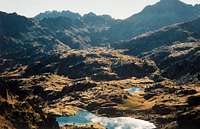
If you heard about the Pyrenees and the famous "cirques" (fr.) / "circos" (sp.), you probably know Gavarnie, and perhaps you heard also about Còlomers.
Like the first one, Circo de Còlomers takes its name from its shape of wide amphitheater, but the similarities stop here; Còlomers is about as granitic and full of lakes as Gavarnie is limestone and sharp.
The Circo de Còlomers is ended on the south by a very imposant mountain, Tuc de Còlomers.
Tuc de Còlomers is indeed a complex mountain that gathers several distinct tops.
There is the Gran Tuc de Còlomers, main summit, at 2933m, and the Tuc Blanc de Còlomers, 2876m, very close to each other, separated by a complicated saddle, that can be passed with some acrobatic scrambling.
While Tuc Blanc is directly accessible from Circo de Còlomers, Grand Tuc requires a diversion by its southern slope, or via those scrambles.
Most of the People wo visit the "Circo de Còlomers", tend to climb Tuc Blanc, shorter of access and providing an equally rewarding view to the lakes.
On the other hand, other hikers reaching the area from the south and the Vall de Boí rather seek the main top.
Due to the fact the mountain is distant from any other in the surrounding, both of these two tops provide the same exhilarating feeling of being on some three-thousander, despite the Tuc de Còlomers misses this official status for a story of few meters. Which is indeed an advantage for those looking for quietness !
 Sunrise on the Circo de Còlomers Sunrise on the Circo de Còlomers |
Getting There
 Morning approach
 Looking down
 Lac Major from Còlomers hut
 On the way to the hut
 Estany Clòto
 Morning walk
Circo de Còlomers is located in the only region of the central Pyrenees that belongs to Spain, but located on the north of the water dividing line: Val d'Aran. The historical and cultural backround of this area is very interesting, but would take too much space here.
In short, let's say that Val d'Aran (then Circo de Còlomers) is best reached from France, while ther Boi valley from Spain.
From France and the city of Toulouse, take the A64 motorway and exit at Montréjeau, take the direction of Saint Béat, Vielha, and the village of Tredos. From there, a track leads to Bahn de Tredós where is located a car park. The rest of the track is closed during the high season and 4x4 taxis ensure the rest of the way till the end of the track, on the foot of the trail heading to the Còlomers hut.
From Spain and the city of Lérida, take the 230 road to Benabarre, Pont de Suert, and Vall de Boí. Don't miss the splendid churches with high towers that make the pride of the valley.
Both starting points can be reached via the other country by taking the tunnel of Vielha.
View Larger Map
Routes
 Winter approach
 Lakes...
 Lakes...
 Lakes...
 Pico de Travessani
 Pico de la Ratèra
 The Tuc Blanc de Còlomers is best reached from the Circo de Còlomers.
Circo de Còlomers is in fact divided into two halfs, between which lie a small long peaklet, Tuc de Podo.
The route to climb Tuc Blanc de Còlomers, on the rocky slopes, is quite obvious once we passed this Tuc de Podo.
Both halfs of the Circo de Còlomers are beautiful, and different, so the visit is better made by making a loop. You will see more small lakes in the West half, while the East one contains the largests. The route that goes around the whole circ is precisely described in the page of Circ de Còlomers circular trail.
Gran Tuc de Còlomers can also be reached by the east half of the Circo.
From Obago lake, head in the direction of the lake Estanh de Ratèra, until the pass Portau de Còlomers (2729m). Once on the south side, the East slope of Gran Tuc de Còlomers offers accessible routes to the top.
This route can be reached from the Val de Boi (more precisions will be welcome if anyone made it)
More informations on the excellent site of Philippe Queinnec :
http://philrando.free.fr/Aiguestortes.html
Note : Pico Ratèra (2840m, E) and Pico de Travessani (2755m, W) are 2 another interesting mountains that border Circo de Còlomers and that can be climbed during the same visit of the area.
Another more modest viewpoint is the Tuc de Salana (2483), fine top for winter, that offers an interesting panorama also on the Montardo
Red Tape
 Bahn de Tredós in winter
 Estany Long
The south of the peak (but only the south) is located into the area of the
Aigüestortes National Park, with all regulations involved (no flowers picking, etc etc)
 Morning walk... Morning walk... |
Camping
 Gran Tuc & Tuc Pòdo
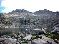 Gran Tuc & Tuc Blanc
 Còlomers ridge
 Estanh Gelat
* Campsites
Some old maps mention a campsite at Bahn de Tredós. Beware, this campsite doesn't exist since more than a decade ago !
The closest official campsites are in Artiès (North) or Barruera, Vall de Boí (South).
* Mountain huts
The only convenient mountain hut seems to be the Refugi Còlomers, at the low end of the Circo de Còlomers :
http://www.refugicolomers.com/
* Bivouacking
It depends on the side of the mountain. As mentionned, the south slope lies in the National park, then the rules are probably more strict (if not forbidden ?). However, I think it is rarely controled. If you plan to, choose a remote and not very visible corner, set the tent or bags at dusk and leave in the early morning. Don't leave any trace or rubbish.
No fire (for the fire risk, but the also the risk to be caught).
And do not wildcamp during the day...
External Links
 Lakes are...
 also for swimming ! :)
Read about Carros de Foc !
http://www.carrosdefoc.com/eng/
Rafa Bartolome - Jul 20, 2009 7:31 am - Voted 10/10
coordinates of summitaccording with my map of editorial Alpina: 42.58342 0.93340 nice page and nice peak
visentin - Jul 20, 2009 8:26 am - Hasn't voted
Re: coordinates of summitthanks ! sometimes it's hard to recognize exactly the place where is a peak with the little google-map applet in SP... Don't hesitate to add some Colomers pictures ! I was surprised there was not more on SP already..
Rafa Bartolome - Jul 21, 2009 5:00 pm - Voted 10/10
Re: coordinates of summitI'll search some images, but I only visited 2 times the area, and I don't climb peaks in Aiguestortes, it's too far from my home to climb in a week-end. It's not a suprise, a lot of important mountains of areas as Aran-Aigüestortes, Andorra, Couserans, Haute-Ariège, Cerdanya, Canigou, Puigmal... don't appears in SP because I can't trip in only 2 days to climb it. Nobody writes to SP in these zones. thanks for the page
visentin - Jul 22, 2009 2:07 am - Hasn't voted
Re: coordinates of summitI'll try to submit more mountains in the area ! I can sumbit : Marimanha/Baciver, Tuc de Vielha, Tossal de Mar, Sarrahèra. Further east, I have never been too... (too far, like for you !) I'll also try to submit the Turon de Néouvielle and the Hourgade in a near future, these are 2 major peaks really missing on SP
Rafa Bartolome - Jul 30, 2009 1:01 pm - Voted 10/10
Re: coordinates of summitI climbed Turon de Néouvielle and Trois Conseillers the last week from Refuge de la Glère. It's a fantastic peak with a wide landscape. I'll write the page in the next weeks. I'll write to you then and you'll can add your images to this nice peak. I climbed as well Crabonouse and Bugarret but are less important for the moment to make a page. I think that's the order of my next pages: Sotllo, Montcalm, Refuge de la Glère, Turon de Néouvielle, Trois Conseillers. If you write the Pico del Puerto de Vielha o Tuc deth Port de Vielha (you know I prefer the original name) I have a lot of images of my climb.
visentin - Jul 31, 2009 2:23 am - Hasn't voted
Re: coordinates of summitFor now I'll be away for 3 weeks in France ! So I doubt I have time for new pages.. One of my last ideas (because I tend also to look for peaks on which I, plus other SPers, have significant amount of pictures), was Pico de Pineta (Pic de Pinède). I also thought about making Turon, but the present pics on SP are very scarce, and mine are a bit old and small. But if you make it I'll try to add them possibly today ! If you don't mind, I will also "book" the idea of the route of the 3 Conseillers ridge to the Néouvielle Peak :)
Rafa Bartolome - Jul 31, 2009 12:09 pm - Voted 10/10
Re: coordinates of summitGreat! teh ridge Trois Conseillers is great. I don't climb it but it's a classic rock-climb. I added some images last days taken from the Pic de Trois Conseillers in the page of Néouvielle