
-
 4345 Hits
-
 81.84% Score
-
 14 Votes
|
|
Mountain/Rock |
|---|---|
|
|
39.33420°N / 105.6227°W |
|
|
Hiking |
|
|
Spring, Summer, Fall, Winter |
|
|
11395 ft / 3473 m |
|
|
Overview

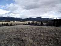
Mount Silverheels dominates the big country views to the west
Yet another Tarryall Mountains peak with no name, UN 11395 was once UN 11391, based on the USGS spot elevation given. However, a higher bump to the northwest of the USGS highpoint moved the summit almost a quarter mile to the northwest while increasing the interpolated elevation by 4 feet.
With no name and no trail to its summit, this pleasant peak sees little traffic. Thanks to nearby Forest Service roads, however, it is relatively easy to access to those comfortable traveling off-trail in timber. Nearby views of the Kenosha Twelvers command the attention of visitors to this summit. Big-country views of the Mosquito Range are available to the west of the rocky summit outcrop. Mount Silverheels dominates these western views, rising big and graceful above South Park.
Rank: 1606th highest peak in Colorado
Prominence: 375 feet
USGS Quad: Topaz Mountain
Rank & Prominence: Lists of John
Getting There

As the crow flies, UN 11395 is located about 8 miles due-north of the Tarryall Reservoir and about 8 miles southeast of Kenosha Pass. The Tarryall Mountains are sandwiched between Park County 77 to the southwest and the Kenosha Mountains to the northeast. The primary access roads are Park County 77 for southern access and Lost Park Road (Rt. 56) for northern access.
Red Tape

Kenosha Mountains from the UN 11395 summit
UN 11395 in situ
There exists little or no red tape in this part of the National Forest. Topaz Mountain sits outside of the protection of the Lost Creek Wilderness. |
Camping & Lodging

Summit ridge outcrop
Plenty of camping can be found along Park County 77 and spur roads off of it. In the case of rustic 4x4 campsites, remember to bring plenty of water, bury human waste and pack out what you packed in.
Lost Pass Trailhead
If approaching this peak from Lost Park Road, at least three fire rings are present right off the dirt road at the summit of Lost Pass. This will be dry, rustic camping very close to the road with little privacy.
Along Rt. 39 & 56
Several campsites off Rt 39 provide views of Mt. Silverheels, Buffalo Peaks, Horseshoe Mountain, Bald Mountain and Mount Guyot and other 13ers and 12ers that will bring tears to your eyes. Competition for these sites, however, is intense in the summer, with large armadas of ATVs and RVs staking weekend claims to favorite haunts.
South end of Hwy 77
The south end of Hwy 77 (Tarryall Road), near Hwy 24, provides several established U.S. Forest Service camping areas. South Park Ranger District Lake George Area Campgrounds include: Riverside, Spillway, Happy Meadows, Round Mountain, Spruce Grove, and Twin Eagles. Please contact the district office at (719) 836-2031 if you have additional questions about the campgrounds in the South Park Ranger District.
North end of Hwy 77
The north end of Park County 77 and dirt spur roads are abound with off-road campsites.
Cabins, Lodges and Hotels
Numerous cabins can be rented in and around Lake George. There are also a few cabins/lodges along the Tarryall Creek catering especially to the fly fishing visitor. For example: Ute River Ranch. There are a few hotels in Fairplay.
Weather & Seasons

Sub-summit outcrop
Due to seasonal closures of Forest Service Roads, UN 11395 is accessible via FR 39 between early summer and late Fall, depending on snow pack. Exactly when the Forest Service closes the gate on FS 39 in the fall and opens it again in the spring varies greatly from year to year. While Park County 77 is plowed, access to this peak from the south will be hampered by heavy snows, lengthening your approach to this summit. The access roads in this area melt out earlier and get snowed-in later than many higher-altitude, heavier-snowpack climbing areas in Colorado. If you want solitude, visit this peak in snow season. Summer, in particular, brings heavy, heavy crowds to the Lost Park area. Campsites are at a premium in the warmer months, traffic is thick, motorized recreation is heavy and other visitors swarm the dirt roads. |
External Links and Additional Information

North from the summit

Toward the true summit
•Pike & San Isabel National Forests
•Pike National Forest Recreation Map