
-
 7486 Hits
-
 84.27% Score
-
 18 Votes
|
|
Mountain/Rock |
|---|---|
|
|
39.27480°N / 105.7331°W |
|
|
Park County |
|
|
Hiking |
|
|
Spring, Summer, Fall, Winter |
|
|
9928 ft / 3026 m |
|
|
Overview
 Prayer flags flutter from the summit of UN 9928
with North Twin Cone Peak and South Twin Cone Peak in the background.
06 Jan 2008
UN 9928 is an officially unnamed but ranked rugged little mountain situated northwest of Observatory Rock. The 360 degree views from the summit of this lonesome highpoint will knock the socks off the most seasoned mountain hiker. (Note: A sign posted on the summit ghost tree declares the mountain to be named "Murf Mt.", though I do not believe the usage of this title to be widely used in the area.)
Seventy-two feet shy of 10,000 feet, UN 9928 provides a summit experience punctuated by a good 50 feet of Class 2 route-finding over balanced bounders of Pikes Peak granite. The summit is celebrated by prayer flags strung between ghost trees. Less than one mile round trip, a journey to this summit provides amazing bang for the buck.
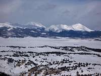
Clockwise starting northward the views include:
- North Twin Cone Peak (12,323 feet)
- South Twin Cone Peak (12,265 feet)
- Bison Peak (12,431 feet)
- McCurdy Mountain (12,168 feet)
- North Tarryall Peak (11,902 feet)
- Topaz Mountain (11,687 feet)
- Burntop (11,085 feet)
- Farnum Peak (11,377 feet)
- Little Puma (11,449 feet)
- Puma Peak (11,570 feet)
- Mexican Ridge (various, approximately 9,000+ feet)
- Michigan Hill (9,942 feet)
- Mount Silverheels (13,822 feet)
- Square Top Mountain (13,794 feet)
The list goes on and on.
 Final approach to the summit of UN 9928
Colorado Rank: 2,351st highest mountain in Colorado
Prominence: 388 feet
Rank and Prominence Reference: Lists of John
Getting There
 Looking north-northwest from the summit of UN 9928. 06 Jan 2008
From Park County Road 77 take Stage Stop Road south. Turn right on Wells Fargo. Out of respect for nearby property owners, I’ll stop here and allow the hiker to figure out the rest. The hiker that wants this summit badly enough will use a map to navigate to a suitable “trailhead”.
Red Tape
 Approaching UN 9928 from the southwest. 06 Jan 2008
Now, the bad news. While the summit sits on public property, UN 9928 is completely surrounded by private land. Please respect private property rights.
For the record, while the author owns property within a mile of UN 9928, the author does not own property adjoining the public land, nor can the author obtain or grant access to this land bordering the public property. If the hiker does not know anyone with property bordering the public land, it’s recommended that the Indian Mountain Property Owners Association be contacted.
Sadly, the Bureau of Land Management plans to "dispose of" this property (i.e. put it up for sale). Eventually the entire hike, summit included, could sit on private property and be entirely inaccessible to the public.
Camping & Lodging
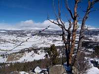 Ghost tree and prayer flags from the summit of UN 9928. 06 Jan 2008
The south end of Hwy 77 (Tarryall Road), near Hwy 24, provides several established U.S. Forest Service camping areas. South Park Ranger District Lake George Area Campgrounds include: Riverside, Spillway, Happy Meadows, Round Mountain, Spruce Grove, and Twin Eagles. PLEASE CONTACT THE DISTRICT OFFICE AT (719) 836-2031 IF YOU HAVE ADDITIONAL QUESTIONS ABOUT THE CAMPGROUNDS ON THE SOUTH PARK RANGER DISTRICT.
North end of Hwy 77
The north end of Park County 77 and dirt spur roads are abound with off-road campsites. Several campsites off Rt 39 provide views of Mt. Silverheels, Buffalo Peaks and other 13ers and 12ers that will bring tears to your eyes.
Observatory Rock / Eagle Rock Area
Spotty camping may be available in the vicinity of Observatory Rock and Eagle Rock to the southwest of Park County 77.
Cabins, Lodges and Hotels
Numerous cabins can be rented in and around Lake George. There are also a few cabins/lodges along the Tarryall Creek catering especially to the fly fishing visitor. For example: Ute River Ranch. There are a few hotels in Fairplay.