
|
|
Mountain/Rock |
|---|---|
|
|
9.57908°S / 77.30891°W |
|
|
Hiking, Mountaineering |
|
|
Winter |
|
|
18773 ft / 5722 m |
|
|
Overview
Tucked away deep in a quiet part of the southern Cordillera Blanca lies the beautiful glacier covered mountain Uruashraju, or Nevado Uruashraju as it is sometimes called. Despite its respectable altitude of 5722m, few climbers go there, so those that do are almost guaranteed to be alone. I can think of several reasons for that.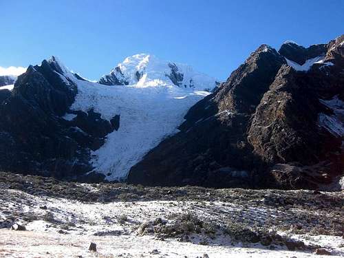
Uruashraju from the head of Quebrada Rurec
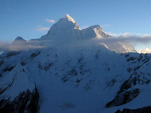
Nevado Huantsán
But, if you don't mind all this, your reward will be a wonderful climb and breathtaking views along the way.

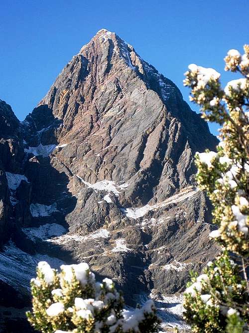
Nevado Rurec from HC
The southern Cordillera Blanca is dominated by Nevado Huantsán (6369m), which looks magnificent no matter from which direction you see it. Uruashraju lies 7km further south. Apart from Huantsán, all the surrounding summits are lower, but several only by a small margin. Consequently you have to get close to Uruashraju to get a good view. There are several peaks between the two, and judging by the contours on the map[1], the saddle between Nevado Rurec (5700m) and Cerro Alpishpunta (5344m) is the lowest point at just over 5200m. Since the saddle between Nevado Rurec and Huantsán is higher, that gives Uruashraju a prominence of approximately 500m.
From the Callejon de Huaylas, the main valley running west of the Cordillera Blanca, there are always other hills and mountains in between, notably Cerro Arhuay (5521m), Nevado Shacsha (5703m) and Nevado Cashan (5716m). To the east, the mountains are substantially lower, none reaching the 5000m mark, but still high enough to obscure the views from the settlements in the valleys, of which Chavín de Huantár (3137m) is the most important.
So, to see the mountain, you either have to get close or find a high vantage point so that the surrounding mountains are not blocking your view.
While getting to the base of the mountain is easy, climbing it is a different matter. The normal route for Uruashraju starts from the west, in Quebrada Rurec. This is a long valley, mostly quite wide and with steep walls, carved out by the glaciers.
By the time you finally see the mountain, near Laguna Tararhua at the end of the valley, you're less than 3 km away from the summit. However, the last part of the route is far from straight and not exactly easy, so it's best to plan two days for the ascent, with a high camp somewhere on the glacier.
Three ridges join on the summit: from the north, the east and the most pronounced one, from south by southwest. On that ridge, some 400m from the summit, lies the southern buttress. From there the ridge splits into the western and southern ridges. In addition, there is another, rather unpronounced ridge from the west that joins the south by southwest ridge shortly before the summit.
The first ascent was from Quebrada Rurec via the west ridge, by Domingos Giobbi and Carlo Mauri, July 17, 1966.
Hikers on the Olleros - Chavín de Huantár trail pass south of the mountain, and can have excellent views of it during the hike in Quebrada Uquian and the ascent towards Punta Yanashallash (4700m), the high point of the trek, about 4km to the south east.
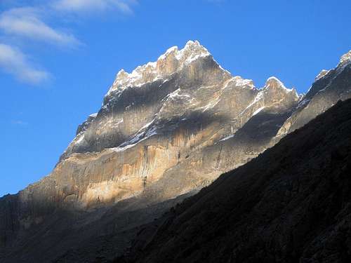
Cerro Arhuay
Nevado Shacsha
The paddle points to Nevado Uruashraju.
Getting There
 Huaraz
The Approach
From Huaraz, you can arrange for a taxi to the entrance of Quebrada Rurec - that is, as far as the taxi can make it, which in turn depends on the state of the road and the taxi. In our case, it was somewhere just above 3900m (at, or close to (9.662°S / 77.415°W)) and a little over half an hour from the entrance. Alternatively, take a colectivo to the town of Olleros, south of Huaraz, and go by taxi or walk to Quebrada Rurec from there. If you walk, count on a couple extra hours.Make sure you take the road on the north side of the valley, past Canray Grande, and not the southern road that leads to the hamlet of Agocancha and Quebrada Uquian, and from there to the Olleros - Chavin trail. Should you accidentally end up at Agocancha anyway, you can still get to Quebrada Rurec, but the start is some 200m lower and you'll have to walk a couple more kilometers.Of course, if you have arranged for an arriero, ending up at the wrong trail head wouldn't be a good idea; you better show up where he is waiting for you. We had one of the many agencies in Huaraz take care of the taxi as well as the arriero, so we didn't have to worry about that.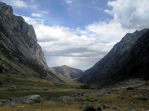 Quebrada Rurec
The normal route
Base Camp
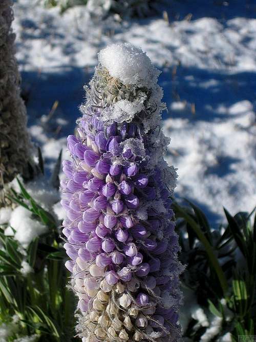 Lupine in Quebrada Rurec
Hitting a wall
 One of our mules at the wall
Lake Tararhua
Past the wall and gate, it's three more hours of easy hiking again. At the end of the valley lies Laguna Tararhua. Shortly before we got there, our arriero went up a zig zag trail on the northern side of the valley. I knew that the lake was on the southern side, but I figured he knew the area. We ended up camping in a nice green meadow, with a small clear stream running through it. Our arriero had chosen that spot because the grass would keep the mules happy. It was roughly at 4550m (9.564°S / 77.331°W). In contrast, the shores of the lake are sandy and rocky, but without mules I would still prefer camping at the lakeside, since it's shorter from there. I advise to look for a flat spot near the head of the lake (9.562°S / 77.321°W).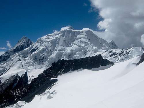 Nevado Rurec from high camp
High Camp
From the head of lake Tararhua, follow cairns up a moraine on the east side of the stream feeding the lake, heading north by northeast. After a while, the cairned trail turns more towards the east, and you might need to use your hands occasionally. Eventually, the trail leads to the glacier at around 4850m (close to 9.557°S / 77.314°W). There were a few small ponds, and it would not have been a bad camp site. However, to get to the summit from there would require a very early start and searching for the route in darkness.Instead, we put up our high camp on the glacier, 1 km due south of here, close to (9.569°S / 77.312°W). Getting on the glacier is easy. However, the route over the glacier isn't straight: to avoid obviously steeper terrain and crevasses, start out to the east and then make a wide turn to the south. We crossed a small ridge to get into the glacier basin to the NW of Uruashraju Norte, and camped there.In fact, we had planned to cross the west ridge coming down from Uruashraju Norte and camp on the other side, but since we discovered that we forgot some of our food, we set up camp early, and my partner headed down to BC and back up again to get more food. Looking back, it was a fine place to camp.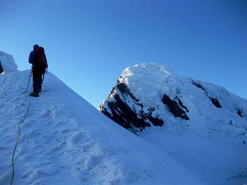 On the west ridge of Uruashraju Norte, with the main summit on the right
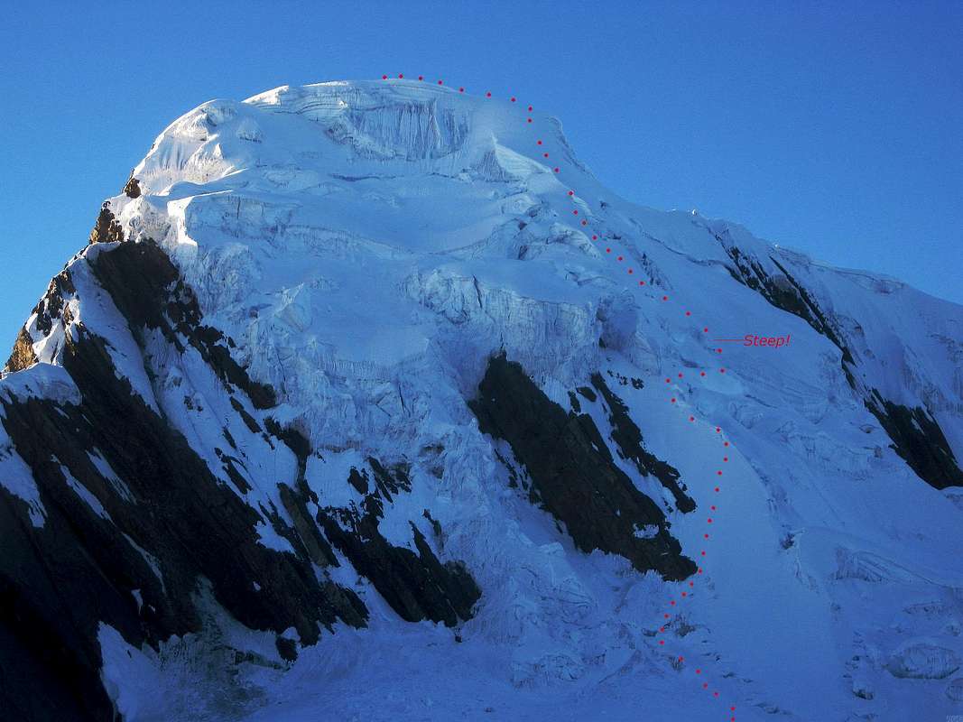 The route to the summit, seen from the west ridge of Uruashraju Norte
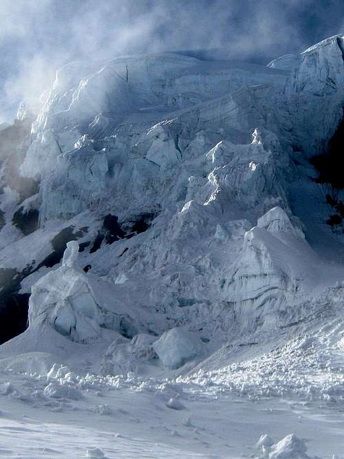
A closer view of the seracs all over the NW face

An inviting ramp
Although the weather was very clear earlier on, once we were up the ramp, the clouds moved in rather quickly. We couldn't see very far anymore. However, there seemed to be only one obvious way to continue, since a few big crevasses and a steep ice wall on our left were blocking our way. So we traversed to the right for a couple of minutes, until we could cross the crevasses at a place where the wall on the other side wasn't vertical anymore. It was still icy and steep (see photo), but manageable. As it turned out, this was the crux of the route. We used an ice screw here, but after that the route was less steep.
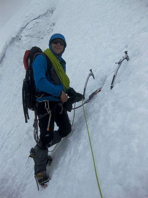
Pierre belaying me on the crux
As we continued to climb, we still couldn't see very far, but there was always an obvious way to get higher. We encountered the occasional crevasse, but didn't have to make a big detour anywhere. Eventually, we got on an exposed ridge in a whiteout. The ridge gained altitude gently, and a short while later we reached the highest point. The last minutes we had been following the south by southwest ridge.
There was no wind, so it wasn't cold, and we waited on the summit for a good time for the clouds to open up, but we were unlucky.
It wasn't a particularly long climb, but judging by the steepness of the ramp and especially the crux, I would rate it AD. If it were more icy, it would have been harder.
Red Tape
The whole of the Cordillera Blanca lies in the Parque Nacional Huascarán. To enter, you need a ticket, which costs 65 soles (in 2011). On the ticket it says that it's valid for a week, but in fact it's valid for a month.To climb anywhere in the park, you need a special permit. You can get one at the park office in Huaraz. It's free, but you have to prove to the officials that you know what you're doing - one way to do so is to show your alpine club membership card. When I went to get my permit the day before heading out, the official in charge of permits wasn't around, and he wouldn't be back for a few days. Considering that we were going to a real quiet part of the park, I figured that the chance of running into a park ranger who might ask to see our permit was low, so we went without one.
Accommodation

Building at the entrance of Quebrada Rurec (9.639°S / 77.386°W)
At the entrance of Quebrada Rurec stands a building, of which, at first sight, I thought it was a misplaced school. However, our arriero explained that the local community had built it as part of an effort to promote tourism in the area. Perhaps it's possible to stay there in the future. There are plenty of hiking opportunities, in Quebradas Rurec, Uquian as well as lower down; there are big steep walls in Quebrada Rurec waiting for rock climbers and there are plenty of opportunities for mountaineers. Apart from Uruashraju itself, there are Uruashraju Norte (5464m), Rurec (5700m) and the easier Cerro Alpishpunta (5344m), to name a few.
In Quebrada Rurec you can camp wherever you like. Some areas are a bit swampy, but there are still plenty of fine sites.
When To Go
The best time of year for mountaineering in the Cordillera Blanca is June to August, and Uruashraju is no exception. Precipitation levels are low, and the snow has had some time to settle since the wet season.Maps And Books
[1] The best map is the Alpenvereinskarte 0/3b Cordillera Blanca Süd (Perú), 1:100000.[2] John Biggar: The Andes - A guide for climbers, 3rd edition, 2005. ISBN 0953608727.

Pierre and me on the summit
External Links
Report of the first ascent, from Quebrada Rurec via the west ridge. American Alpine Journal, 1967, page 385-6.Report of the second ascent, from Quebrada Pumahuacanca via the south ridge. American Alpine Journal, 1976, page 388.