
|
|
Mountain/Rock |
|---|---|
|
|
45.82590°N / 7.87857°E |
|
|
Piedmont, Val d'Aosta |
|
|
Hiking, Mountaineering, Via Ferrata |
|
|
Spring, Summer, Fall |
|
|
10892 ft / 3320 m |
|
|
Overview
An hideout for Witches.Corno Bianco("White Horn", in english) is the highest summit of the watershed between piedmont and Valle d’Aosta apart from Monte Rosa massif.
Although the border line between the two regions runs along the North ridge, the main summit of the mountain is located entirely in Piedmont, in the territory of Valsesia, the valley that takes the name of the river that streams from the glaciers of the south face of Monte Rosa.
Surrounded by a big crown of satellite summits this massive rocky mountain is not visibile from the villages below, only scrambling till the highest meadows it finally appears above the other peaks like an huge castle of rock.
A real labyrinth of ridges climbs to the top of the mountain forming numerous pinnacles and enclosing steep gullies and narrow cirques. Ancient glaciers, whose remains are still visible under the impressive north wall or in the upper part of Puio gully, carved the flanks of Corno Bianco creating its actual dramatic figure.
Due to the complexity of its topography and to its remote position the routes to corno Bianco are long and articulated, an ascent to the summit is a kind of trip through almost all the faces of alpine environment, across woods, meadows, fields of snow and debris, along the shores of sweet lakes or on the edge of narrow ridges.
Its remote position, together with its fierce aspect, is the cause of the numerous stories invented by the inhabitants of the area, one of these tells that its summit was used by witches as an hideout while another one tells of a wild man living alone under Puio gully, in the cirque where the two lovely lakes called Thaily are located, that used to descend in the villages below to rob and kill.
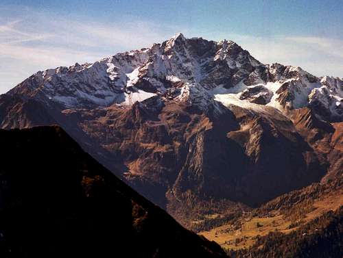 Fall on Corno Bianco
Faces
- from Cima Mutta, E- from Tagliaferro, NE
- from Quintino Sella hut, N
- from the Lyskamm, Monte Rosa, NW
- from Bianco lake, SW
 |  |  |  |  |
Getting there
The trailhead in Valsesia are Alagna and Riva Valdobbia.To get there the quickest route follows the A26 Milano-Genova Highway till the exit of Romagnano, then goes on along the main road of Valsesia.
Alagna is the last village of the valley, Riva is just a few kilometers befor.
The trailhead for the Lys side (Val D'Aosta) is instead Gressoney, easy reachable from the Point Saint Martin exit of the Torino-Aosta Highway and then following the main road of the Valley. Gressoney is the last village.
 Map of the area around Corno Bianco
Huts
Abate Carestia (2200m), important support point along the most followed route to the summit from Riva Valdobbia.The trailhead is the locality called Ca' Janzo, at the entrance of Vogna Valley, reachable by car from Riva Valdobbia.
The trail is very easy and perfectly indicated, during July and August the hiking can be very warm due to the exposure to South.
The hut is located under Punta delle Pile, near the entrance of Rissuolo valley.
Bivacco Ravelli(2500m), under Uomo Storto pass, in Otro Valley, used to climb the mountain from Aagna.
The trail to Ravelli starts directly from Alagna and crosses the beautiful Otro valley passing by the Walzer villages of Follu and Scarpia.
Passed the locality of PianMisura the path enters the canyon of Rio Cuttiri and finally reaches the hut on the summit of a pinnacle on the hydrographic right of the river(south).
Bivacco Gastaldi(2600m), in Netscho valley, in the remote cirque under the north flanks of Ciampono and Rissuolo peaks, used to start from Gressoney and climb the North ridge.
The trailhead is the locality called La Trinitè.
It's also possible to start from the Gabiet Impound, at 2200m, reachable from Gressoney with a cable-lift.
Routes
Note: the difficulties are reported following the european UIAA scale, both for rock climbing and for global evaluation of the routes.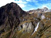 | From 'Vallone(valley)del Rissuolo' (F, I /II, UIAA scale), the most frequented route to the summit and the most pleasant. From Carestia hut the trail enters 'Vallone del Rissuolo', the wide cirque enclosed among the flanks of the main summit and those of Ciampono and Rissuolo peaks. Passing by the shores of Bianco(white) Lake the path finally gets to Nero(black) lake at 2700m, under the SW face of the mountain. From this last lake, through a rocky and wet chimney equipped with some fixed rope ('Artemisia' pass), the route gain the slope of the SW face and with some easy rock climbing reaches the summit. |
 | From 'Vallone del Forno' (F, I /II). Vallone del Forno is the steep gully between the SE and E ridges of Corno Bianco, a really savage place, a wide sprawl of naked rocks arising from Alpe le pisse(2100m) to the pinnacle called 'Punta del Forno'(3198m). Due to the exposure toward south and to the complete absence of vegetation the sun is sometimes pitiless in this place, 'Forno' means in fact oven in Italian. The acces to 'Vallone del Forno' is shorter than the one to 'Vallone del Rissuolo', this route is in fact the most direct to the summit, but is less climbed than the Rissuolo one because no hut is located along the trail. The trailhead is once again Ca' Janzo and the route follows initially the one of Carestia hut. After a few kilometers, near a small Walser village called Cambiaveto, you have to leave the Carestia trail and follow the path marked with the number 11 that climb directly toward North. Passing by Alpe le Pissole and Alpe le Pisse and crossing the last green meadows above, this path, that often is marked only by a series of cairns and signs painted on the rocks, reaches the entrance of the gully. Follow entirely the gully till the elevation of 3000 meters, where you have to climb a small dihedral tha ends at Forno pass (sometimes called bocchetta del Merlo, Blackbird pass in english), on the left (West) of Punta del Forno. Through this pass cross the S ridge to reach the SW face. Then go on following the easy but exposed SE ridge with some pleasant passages on solid rock till you join the route coming from Rissuolo. The technical difficulties are concentrated in the rock dihedral under Forno pass, and on the S ridge, I and II of UIAA scale of difficulties. |
 | From 'Vallone di Puio'(or 'della Pioda') (F, I /II, UIAA scale), This is the normal route from Alagna, a very long one, but the wild scenery of Otro Valley is fantastic. Vallone di Puio is the big gully between the E-NE and E ridges, it was once covered by a small ice field (Puio glacier) that actually is almost completely disappeared or covered by fallen rocks. Puio was the name or nickname of a young guy from Riva that died during an attempt to climb a pinnacle of the the mountain at the beginning of 900. To enter Puio gully it’s necessary to climb a small rocky wall usually called Passo della Pioda(pass of the small rock, 20 meters with a fixed chain, without using the helping chain the difficulty would reach the III degree) right above Thaily lakes, two lovely mirrors of water located in the remote cirque under the cliffs that enclose the gully. To reach Passo della Pioda you can start from Ravelli hut, crossing Otro glacier (entirely covered by rocks) and Thaily pass on the E ridge, or you can follow the direct route starting from Alagna, in this last case you have to cover in one day a distance of more than ten kilometers and gain more than 2000 meters of elevation to the summit. After Passo della Pioda, once that you have reached the upper part of Puio gully, you have to cross Puio pass on the E ridge. The pass is on the left(South) of the pinnacle called Punta del Forno, don't venture through the steep couloir that climb directly to the summit ridge but use instead the system of ledges that crosses the wall on the left of the couloir, there are some cairns and some signs painted on the rocks. On the other side of the ridge you find the trail ascending from the side of Forno gully, climb to Forno pass and then go on following the exposed S ridge to the summit. |
| North Ridge (AD+, III+), a classical rock climbing route of Valsesia summits. From Ravelli hut follow the trail to Uomo storto ('Cripple man') Pass, then follow entirely the ridge, climbing first Uomo Storto peak, then Netscho Peak and finally the main summit. The part of ridge between Netscho peak and the summit is very exposed but not difficult. Uomo storto pass can be reached also from Gastaldi hut, anyhow the approach is not simple, you have to cross the West ridge of Netscho peak and follow an exposed ledge till the pass. An alternative could be to reach "Bocchetta di Netscho" (Netscho pass) right above Gastaldi, between Netscho and Ciampono peak, to climb the W ridge of Netscho peak and join the classical route on this last summit In the case you start from Gressoney remember that the trail for coming back is very long and complicated, you have to descend to Lago Nero by the 'Rissuolo' route and then hike in plane to Alpetto pass(2700m), at the basis of the South ridge of Rissuolo peak. From the pass you finally scramble down to Lys Valley till the locality named 'Chemonal', but you have still to loose more than 1300 meters of elevation. |
North Wall
The North wall of Corno Bianco is a large bastion of rock
The big pillar under the summit that dominates the entire wall has an height of 650 meters and is one of the hardest rock climbing route of Valsesia. This pillar has been climbed for the first time during 1942 but the most repeated route, the direct one, has been climbed in 1962 by Giorgio Bertone, a strong mountaineer of Valsesia that became famous during the 60's and 70's for his performances in the Monte Bianco range. The first ascension of this route during winter belongs to Silvio Mondinelli and another guide of Alagna during the 80's.
The route is evaluated TD (very difficult, UIAA scale), the rock is not always firm, but is good on the hardest part.
The repulsive gully on the right of the pillar has been climbed in 1932, during the first ascension of this wall, but this route has never been repeated, it is in fact very dangerous for rock falls.
 The North face from Otro Glacier
High Route “Tullio Vidoni”(for expert hikers with some I and II), A fantastic route that turns around the mountain crossing the solitary and wild valleys at its feet.
This path is dedicated to Tullio Vidoni, an Italian climber that died during a solitary Ski-mountaineering journey to the Little Altar Pass, in Valsesia.
It normally takes three days.
This route is sometimes hard to find, especially for the part of the trail that crosses under the wild south flank of Corno Bianco, in the area under 'Vallone del Forno', where the trails have almost desappear.
This route passes by Gastaldi, Carestia and Ravelli huts. You can start both from Alagna, Riva or Gressoney. The most of the technical difficulties are concentrated in the part that from "uomo storto" pass crosses to Gastaldi hut and then to Rissuolo pass, under the wild NW flanks of Netscho and Ciampono peaks.
 Map of Corno Bianco Routes
External Links
Alagna homepageThe home page of Alagna. With info about the accomodation.
Gressoney homepage
The home page of Gressoney. With info about the accomodation.
Corno Bianco
Ferruccio page on Corno Bianco, with lovely pictures of the crossing of the mountain by ascending from rissuolo cirque and descending across Puio gully.
Lovely slide show of images taken around the mountain
Tullio Vidoni route on the Italian Alpine site
About Tullio Vidoni and the route whit his name that crosses the valley around Corno Bianco, with images and maps, very useful.
History of Corno Bianco huts
All the huts of Corno Bianco with also historic informations and nice pics.
Gastaldi hut
Otro valley homepage
The site of Otro Valley, you also find here a description of the path to Ravelli hut.
Gastaldi hut
Ravelli hut
Ravelli hut informations.
Carestia hut
Carestia hut inforomations.
Tullio Vidoni trek
Trip report of the Tullio Vidoni route with maps and photos, very nice.