
|
|
Mountain/Rock |
|---|---|
|
|
45.88463°N / 7.96165°E |
|
|
Hiking |
|
|
Summer |
|
|
9199 ft / 2804 m |
|
|
Overview
Corno Mud is the second mountain from North of the ridge that divides the two main valleys of Valsesia, Val Sermanza at east and Val Grande at West.The summit of Corno Mud rises up between Mud pass at South and Piglimò pass at North with a prominence of 500 meters and an elegant profile designed by the grassy southern ridge and the rocky northern one.
Approching the mountain from the valleys below two other ridges climb to the summit with an elevation gain of more than 1500 meters, the west ridge, from Val Grande, forming the massive western shoulder of the mountain, and the East ridge, from Val Sermenza, forming the pinnacle called 'Corno di Rima' (Rima’s horn).
Corno Mud offers more possibilities for hikers with well trained legs than for skilled climbers.
From this summit, when the dampness of Valsesia doesn’t obscure the sky, you can enjoy an incredible view that embraces the big lakes Maggiore and Orta, Monte Rosa, Corno Bianco and the impressive North wall of the near Tagliaferro.
 NW face in Winter
Summit view.
From the summit looking towards Tagliaferro, Corno Bianco and Monte Rosa. |  | 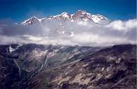 |
Getting there
The trailheads are Rima in Valsermenza and Alagna in Valgrande.To get there the quickest route is to follow the Milano-Genova (A26) highway, exit at Romagnano Sesia and then follow the main road of Valsesia till Balmuccia, here you have to continue on the principal road to reach Alagna or take the provincial road of Valsermenza to reach instead Rima.
Huts
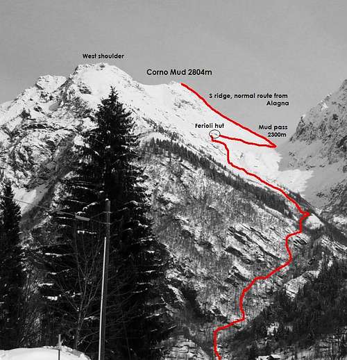
The most useful hut is Rifugio Ferioli (2200m), near Mud pass, reachable in two hours and an half from the locality Pedemonte(1200m), at less than ten minutes of car driving from Alagna.If you intend to reach Ferioli from Rima(1400m) you have to follow the trail for Mud pass, cross the pass and then reach in ten minutes the hut on the side of Alagna.
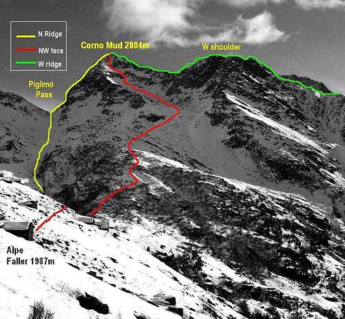
Another hut that you can use during the approach to Piglimò pass and the north ridge or the NW face is Rifugio Pastore(1600m), in the natural park of high Valsesia, under the South face of Monte Rosa, the trailhead for this hut is at the end of the main road of Valgrande, right under the W ridge of Corno Mud.
Routes
South ridge. Normal route. Practiced hikers.The easiest route follows the south ridge from Mud pass, this ridge is easy but very steep, a good route to test your legs and chest especially if you start directly from Alagna or Rima, with an elevation gain of 1600 meters.
West ridge. F (I/II UIAA scale).
From Ferioli hut get to ‘Belvedere’, a small pinnacle on the W ridge usually reached for the nice view that offers, then follow the ridge entirely without high difficulties but with dangerous steps on the steep and slippery meadows.
North ridge. PD+ (II/II+ of UIAA scale).
On the north side of the mountain the ridge that ascends from Piglimò pass offers an easy rock climb on solid rocks but with some lichens that can become very slippery when wet.
The trailhead to Piglimò pass is Pastore in ValGrande or Rima in Valsermenza, the trails are well signed and easy.
If you hike from Val Grande, the first part of the trail until Alpe Faller is in common with the one of Turlo pass.
NW face. F+ (I/II of UIAA scale).
This side of the mountain, facing Val Grande can be reached by the trail to Piglimò pass.
The route is not difficult but there are no signed path so you’d better have a clean sky and some guess in finding the right way.
Before entering the rocky colouir followed by the trail to Piglimò pass, right after the buildings of Alpe Faller, hike in plane towards south till the beginning of the first slopes of the NW face.
Hiking on these slopes you easily reach a cirque occupied by fallen rocks, right under the pass on the West ridge between the summit and the West shoulder.
From here you can head to the pass and reach the summit by the W ridge or you can scramble directly to the summit by a steep colouir with some unstable rocks.
 |  |
External Links
AlagnaInformations about huts, trails and sleeping possibilities.
Ferioli hut
Informations about ferioli hut.
Pastore hut
Informations about Pastore hut.