
|
|
Mountain/Rock |
|---|---|
|
|
38.75400°N / 104.948°W |
|
|
11499 ft / 3505 m |
|
|
Overview
*** I recently adopted this page and will be updating it soon. If you have any good suggestions for additions please feel free to let me know.Climb On!
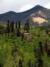
Mount Rosa isn't the biggest or most recognized peak in the southern Front Range, but that's what makes it so special. Rosa is the cone-shaped mountain in the Colorado Springs skyline south of Pikes Peak. Mount Rosa shares the distinction of being in the Pike National Forest just south of Pikes Peak and is one of the few pointy mountains in the Front Range.
This mountain is now thought to be the actual mountain climbed by Zebulon Pike in 1806 rather than the nearby Pikes Peak. He set out from the south trying to reach the tallest point in the southern Front Range, and it is believed that he mistakenly climbed and camped in a cave just on the east side of Mount Rosa beneath the summit. As he reached the top, he discovered that the tallest point, Pikes Peak, was actually miles away to the West and many more mountains stood in his way. Look for a book (currently being written) entitled, "Tracking Pike Across Colorado" by John Murphy where he goes into detail about this research.
 |  |  |  |  |
Getting There
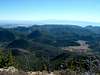
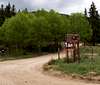
Standard Frosty Park Route: From Colorado Springs take Old Stage/Gold Camp Road approximately 12.5 miles to 379 (close to the Penrose-Rosemont Reservoir). Turn north on 379 and travel on the 4WD road to Frosty Park for another 1.5 miles. This is a large clearing on the right with no apparent signs other than the tracks of many mud rides. At the north side of this clearing is the trailhead for Nelsons Trail.St Mary's Falls Route: There is also another route which I have not taken that originates in the North Cheyenne Cañon Park heading up to St Marys Falls. This is a much longer hike with more elevation if you're looking for more of a challenge. Thanks to cftbq for the information about this additional route.
 |  |  |
Red Tape
- Motorized vehicles are not permitted on the trail.- Need a higher-clearance vehicle to get to trailhead unless you hike an extra 1.5 miles from Gold Camp Road.
For more information, contact the Forest Service at:
Pikes Peak Ranger District Phone
601 South Weber
Colorado Springs, CO 80903
(719) 636-1602
When To Climb
The southern Front Range clears of snow quickly, but check general conditions for the area. As usual, watch out for afternoon storms in the summer.Camping
There are some excellent places all along the trail that would have fantastic views of city lights. There are also several large fire pits already set up just off the beginning of Nelsons Trail that would make for great campsites not too far from the car.Mountain Conditions
Local weather in Colorado Springs:
External Links
- Zebulon Pike's Mistaken Identity
This article describes a researcher who believes that Zebulon Pike accidentally climbed Mount Rosa thinking that it was Pikes Peak (he called it Grand Peak).