
|
|
Canyon |
|---|---|
|
|
34.23450°N / 117.845°W |
|
|
Hiking, Bouldering, Scrambling, Canyoneering |
|
|
Spring, Summer, Fall, Winter |
|
|
Overview
I took this page over from Taco in October of 2011. The majority of the information is from him. I have added some additional information reguarding the east fork, but since I am not familiar with the west fork I am unable to do likewise for that area as well.The San Gabriel River and canyon are situated in the San Gabriel Mountains, northeast of Los Angeles. The canyon terminates north of Azusa. North of there, the canyon moves through the San Gabriel Mountains, eventually breaking off into two primary forks, East and West fork.
West Fork is broader, and draws its water from sources around Mt Islip, Crystal Lake, the Mt Hawkins area, and Cogswell Dam in the west. There are many popular trails in the area, some of which go into the San Gabriel Wilderness around Twin Peaks, which is one of the San Gabriel Mountain's best kept secrets.
East Fork is home to the famous "Bridge to Nowhere", at the foot of Iron Mountain's western ridgeline. This is one of the deepest canyons in Southern California, and the further north you head, the cleaner the water is, and the better the scenery.
There are places for sportsman guys to fish and hunt in the area. Fishing is mostly lightweight fly fishing, with some trout. Hunting depends on tags and sections. You can get more information from either the Forest Rangers Office, or from a local sportsman's store.
Overall, this is a nice, rather historical canyon with a lot to offer for those who want a quick way to get out of Los Angeles and into somewhat-untouched wilderness. The water is generally cool, clear, and clean, and there are plenty of nice places to camp off the beaten path.
On the downside, this is Los Angeles County. I spend a great deal of my free time in and around this canyon and the various neighboring canyons. There is trash along the roads, along the streams, beer bottles everywhere, used condoms, tons of graffiti, endless pointless names etched into trees, and tons of people drinking and swimming in various pools. On the weekends, this area gets very busy. Please, take my words of caution, and park your vehicle somewhere out of the way of major foot traffic, yet in an area where you feel it will not be vandalized. Many low-life people from inside Los Angeles and neighboring cities and communities come up here and take advantage of the general lack of authorities in the area.
If you want peace, solitude, clean water, then you must beat feet and move into such areas as the Narrows in East Fork, Bear Creek and the San Gabriel Wilderness in the West Fork, and generally anywhere too far for a gang member to walk.

Getting There
From LA and The Inland EmpireThe best route is to take either the 10 or 210 freeway east out of Los Angeles. Exit onto AZUSA AVENUE, and head north towards the mountains. AZUSA turns into San Gabriel Canyon Road, which weaves north through the mountains.
There are smaller canyons off this major canyon, all part of the various rivers and streams that run off the springs and snowmelt in the surrounding mountains. Route 39 (AZUSA AVE) takes you to most of these along the western fork of the river. Depending on conditions, Route 39 may be closed at one of several points. We had severe fires in the area around 2003, and there are smaller ones each year in the area, which close down the roads, mostly due to erosion.
From the North
The northern end of the east fork canyon is easily accessed from the trail head at vincent gap. This is also the trail head you would use to access mt. baden-powell.
Red Tape
A National Forest Adventure Pass is required to park in any National Forest owned land. Day passes cost $5 USD, while annual passes cost $30 USD.They can be purchased at the liquor store on the corner of Azusa Avenue, and Sierra Madre, or at any BIG-5 Sporting goods. Turner's Outdoorsman states that they carry them too.
Target shooting is allowed at one site, Burro Canyon Shooting Range. It is on the east fork, off route 39 over the first bridge. It is open weekdays 9AM to 5PM, and offers some basic facilities to shooters.
Burro Canyon Shooting Park
Camping
There are various campgrounds in the area, notably near Heaton Flat on the East Fork of the San Gabriel River, and camping is generally allowed throughout the San Gabriel mountains and Sheep Mountain wilderness. So far as I have seen, they just don't want campers to use open fires unless in designated campgrounds, and only during times of the year when it isn't very dry down here (high fire threat level), which sadly, is never.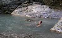
Gold prospecting
One of the more popular uses for this area is gold prospecting. The legality of this hobby is questionable and you need to be aware of the laws pertaining to it. Basicaly my understanding of the situation is that the forest service says prospecting is illegal based on the california 1938 watershed protection act. However they generaly do not write tickets for prospecting because they do not want it to go to court. They will however write tickets for everything else if you piss them off so if asked to pack up your prospecting equipment I would recomend doing so. Gold is often obtained in very small amounts, but larger nuggers do still occur.External Links
San Gabriel Canyon Off-Highway Recreational Vehicle AreaAngeles National Forest Page
Nearby Peaks / Climbs
Nearby mountains worth climbing include:Iron Mountain - 8,007ft (previously known as "Sheep Mountain")
Mt Baden Powell - 9,400ft (or 9,399ft)
Mt Hawkins - 8,850ft
South Mt Hawkins - 7,783ft
Pine Mountain (Western San Gabriels) - 4,539ft
Rattlesnake Peak - 5,826ft
Ross Mountain - 7,402ft
Smith Mountain - 5,111ft
Throop Peak - 9,138ft
One thing I must include to those of you who wish to climb and hike in the area, the chaparral gets VERY DENSE. Scrub Oak trees here often only grow to about 12ft tall, with their branches densely growing to the ground. Passing can be difficult if not "impossible" as far as low-impact hiking is concerned. On the northern slopes, you will find the usual Black, Sugar, and other types of pine trees.
Other Points of Interest
The Bridge to Nowhere
One can reach the Bridge to Nowhere by taking the road (Azusa - Route 39) through the canyons until you reach the first bridge crossing the river. Cross the bridge and stay on that road until it crosses the river once again. Be careful as there is an intersection at which you are sort of forced to turn onto Glendora Mountain Road. At this intersection, you must turn left to stay in the canyon. It looks a little illegal at first.
The road ends in a short period of time at Coyote Flat. There is a parking area provided. You can park there, and follow the trails north through the canyon. The bridge is approx. 5 miles into the canyon.
You can follow either the primary trail, or follow the bed of the river to the bridge. Following the river means you must have your gear waterproofed, or simply don't carry any electronics (cellphones/radios), as you will get wet, and you must gear yourself up to be completely immersed in water. The river may be shallow, but the current is strong enough to take you off your feet if you aren't careful.
If following the river (off trail), as you close with the bridge, you will have only one route to reach the bridge, and that is by swimming through one of the larger pools, as seen in one of my photographs. The water is cold, but it is refreshing after the hike in.
Bungee America offers jumps off this bridge. I watched a large group attending a jump, and it looks like a lot of fun.
Nuclear Highway
Shoemaker Canyon Road was partially built in the 1960's as a means of escaping Los Angeles in the event of a nuclear attack (according to some sources). There are two tunnels that run along the road, before the toad eventually turns into a footpath.
The tunnels offer shelter in bad weather, if you get caught in the area. While the area is closed off to vehicles, it is still a very nice short mountain biking route for those of you who are interested.
Unfortunately, morons with cans of spray paint have graffiti'ed the exit to the second tunnel, and other places.
Bighorn Mine
 Bighorn Mine which sits above Mine gulch near the begining of the East Fork can be easily reached from vincent gap off of highway 2.
The bighorn mine is an interesting place to hike to. The hike is much easier to get to than most places in the canyon and the crowds in this area generaly congregate around the southern trailheads which are closer to LA.