
-
 4609 Hits
-
 84.82% Score
-
 19 Votes
|
|
Mountain/Rock |
|---|---|
|
|
44.41290°N / 109.0493°W |
|
|
Park |
|
|
Hiking, Scrambling |
|
|
Spring, Summer, Fall, Winter |
|
|
6220 ft / 1896 m |
|
|
Overview
 Crater Benchmark and Peak 6210
The mountain south of Cody, Wyoming known only as Crater Benchmark is most easily accessed by climbing nearly all of the way to the top of neighboring Peak 6210, so I have decided to cover both mountains in a single page rather than post two pages with very similar information. Almost identical in height (about 10 feet separates them), hiking these mountains provides the off-trail explorer with amazing, wide-open views and can be done any time of year.
Located in the Big Horn Basin, the dry climate and the lack of significant precipitation make the land around and on these mountains a sagebrush-covered paradise for sage grouse, foxes, and rattlesnakes. You may encounter cows as well; the herd that I had to walk through on my way to the summit was a little alarmed by my presence, even after I explained to them that I was just passing through to the summit!
From the top you will have a great view of the eastern tips of the three parts of the Wyoming Absarokas. In the panoramic summit photo below, Francs Peak, the highest Absaroka Peak and the range's only 13er, is the very small mountain visible in the distance on the extreme left of the picture. Moving to the right, the eastern end of Carter Mountain rises impressively almost 5,000 feet above the valley floor; the South Fork Valley lies to the right of this mountain, dividing the Southeast Absarokas from the large snow-covered Wapiti Ridge, which at 12,163 feet is the highest peak in the Southwest Absarokas. Sheep Mountain blocks the view up the North Fork Valley, which separates the North Absarokas from the SW range. Behind Buffalo Bill Reservoir is Trout Peak, which is Wyoming's 5th-most prominent peak and is the highest in its range at 12,244 feet. To the right of Trout Peak are Cedar Mountain and Rattlesnake Mountain, which just peeks up from behind Cedar's ridge; the east side of the Montana Beartooths and Heart Mountain round out the view.
  |
Getting There and Hiking Information
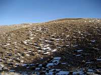 Southern slopes
 Nearing the summit of Crater Benchmark
Drive from Cody towards Greybull on Highway 14-16-20 and turn right on Highway 120 to Meeteetse just past the airport. Travel for just under 8.0 miles and turn right on County Road 3CQ. Drive for 1.5 miles on the dirt road and veer right, traveling around to the south side of the mountain.
 Summit marker
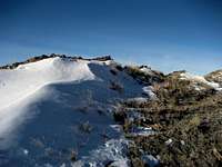 Rock outcrops
Park so that the south side of the Peak 6210 is immediately to your right; walk up the gentle slopes, gaining about 500 feet of elevation. The summit is slightly to the left as you top out on the ridge, and overlooks an interesting bowl that faces north. From here, head northwest down the ridge, which drops about 300 feet to the saddle that connects the peaks. At the bottom of the saddle, cross the downed section of the fence and continue to the top of Crater Benchmark, which is another 300 or so feet up. I thought about trying to descend by a route directly off of the second mountain, but ran into another fence just below the saddle that appears to border the residence and private property in the valley southwest of the mountains, so it's probably best to return by the way that you came up.
 Peak 6210
The total distance for the round trip to both summits is about 3.5 miles with 800-1000 feet of elevation gain on easy Class 2 terrain.
Red Tape
There is a lot of private land in this area, so be on the lookout for posted signs. I am aware of no trespassing issues when following the route posted on this page.As always in the Cody area, watch for rattlesnakes when hiking in the sagebrush in the summer!
 East Carter Mountain
External Links
Crater Benchmark on Lists of JohnPeak 6210 on Lists of John