
-
 39619 Hits
-
 91.13% Score
-
 34 Votes
|
|
Canyon |
|---|---|
|
|
37.66575°N / 111.343°W |
|
|
Hiking, Bouldering, Scrambling, Canyoneering |
|
|
Spring, Summer, Fall, Winter |
|
|
Overview
Consider this page a gift. I wasn't initially going to make this page but then I figured this place wouldn't suffer too much if the visitation increases a little. This isn't your ordinary slot canyon. It's something much more. The loop hike that is described on this page is quite possibly one of the best day hikes I have ever done. Red Breaks lies in the heart of the Grand Escalante National Monument and is known by locals to be one of the BEST non-technical slot canyons in all of the Colorado plateau...certainly the best non-technical slot in the Escalante River drainage basin. If you tell someone in the small town of Escalante that you plan to hit Red Breaks they will know you have done your homework.
The canyon walls of Red Breaks are composed of the traditional Navajo sandstone. Red Breaks is actually an elevated area where a part of the resistant Carmel formation that sits atop the Navajo sandstone hasn't completely eroded away. Surrounding Red Breaks is a sea of yellow-white Navajo sandstone that erodes into the distinctive round knobby hills. This elevated "platform" measures about 5 miles long in the north-south direction and 2 miles wide in the east-west direction. Slicing down the center from north to south is the drainage for Red Breaks where a slot has formed and cut below the Carmel into the Navajo sandstone.
There are 5 forks in the northern part of Red Breaks that all flow southward and converge at the Main Fork of Red Breaks. The main fork continues south and flows into Harris Wash which then flows into the Escalante River.Water rarely flows in these canyons especially since the drainage area is only about 10 square miles but when it does, mainly during summer storms, it really rushes downstream and gouges the slots ever deeper.
Do not enter slot canyons if storms are in the forecast. Below is a strat column showing many of the rock units in southern Utah from the Permian to the Jurassic time periods. Notice the Navajo sandstone and the Carmel formation sits above the Wingate Sandstone that composes the walls of Little Death Hollow and Wolverine canyons.
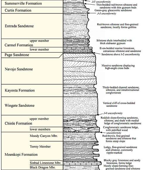 Strat column of the rock layers in southern Utah
The other secret about this area besides its remoteness is a geologic feature known by locals to be the "Cosmic Ashtray" Another name for this geologic wonder I have heard is the Quag Pit. More about this below.
Getting There
To get to Red Breaks go to the town of Escalante Utah which is situated on Highway 12. Five miles east of Escalante off of Highway 12 is a right turn on the famous Hole-in-the-Rock Road. If one drives all the way to the road end nearly 60 miles to the southeast it will take you to the famous "break" in the cliffs above the Colorado River which allowed for Mormon pioneers to be able to descend the cliffs with their wagons down to the river for water and a nice place to settle. This "break" in the cliffs is known as the Hole-in-the-Rock for obvious reasons and the current dirt road follows the same route taken by the pioneers. This road is usually in good condition for the first 45 miles although may be really wash-boarded later in the summer. Any passenger car can usually drive this road to the 45 mile mark where high clearance vehicles become needed. The most dangerous part of the road are some of the cattle guards that some lower clearance vehicles may bottom out on so the one thing I advise is to never drive fast over any cattle guard. The starting point for Red Breaks is the trailhead for Harris Wash.
To get here take the Hole-in-the-Rock road southeast for 11 miles until you see the Harris Wash trailhead sign on the left. Take this side road to its end at Harris Wash; after 6 miles. Here are the coordinates for the official trailhead so you can use Google Earth to look around. Harris Wash drains east while Red Breaks comes in from the north.37 degrees 38.076 minutes North111 degrees 20.423 minutes WestIn March 2010 our passenger car (Subaru) was able to make it when driven carefully all the way to the end of this road but a HCV will be needed to cross Harris Wash and continue north.
Crossing Harris Wash will not shorten your hike though and it's recommended you just start from the official Harris Wash trailhead marked by a sign and a small camping area. Start by crossing Harris Wash. You can't miss it as it's the biggest stream bed around. Do NOT start walking up or down Harris Wash unless that's your intent (Red Breaks is much better). After crossing you will follow the road north for a short distance through a small grove of trees. Follow this road for 260 yards where you will see it cross a small sandy stream bed. This is the Red Breaks drainage and it's imperative you turn left and follow this stream bed upstream. If you stay in the stream bed, you can't get lost.
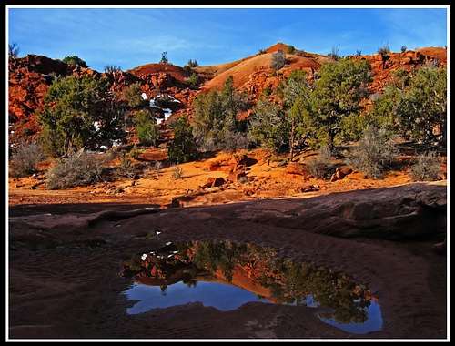 Lingering snow in the Red Breaks drainage
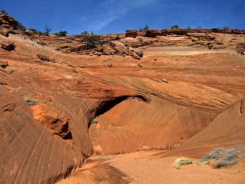
Continue upstream and after about 1.75 miles the main fork begins to narrow up. You will have to bypass a small dryfall by walking up to the west rim a short way up. Just past the bypass, re-enter the canyon and it then rapidly becomes a very nice and photogenic slot that is a simple walk-through with a couple chalkstones to climb over. These may cause single parties grief but two or more people can easily help one another if needed.
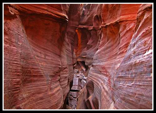 Main fork of Red Breaks slot Main fork of Red Breaks slot |
 Main fork curves Main fork curves |
Since the 2009-2010 winter had been so wet in Utah we ran into some water we had to wade/chimney over when we went in March but this slot is usually dry. The Main fork slot continues for about a half mile and comes out to a small opening. This is a good spot to take a short break as it is an important junction.
 Main Fork opens up...Climb out to the left here on the slabs and hike the rim
This opening is where a number of other forks branch off from the main fork. Your ultimate goal is to ascend the Big West Fork of Red Breaks as this is the slot known to be the best walk through slot around (although the Main Fork was pretty superb too). A large dryfall blocks entry to the Big West fork from the canyon bottom but at the opening of the Main fork shown in the above photo, climb up the left side of the canyon looking upstream (the area shown right in the middle of the photo) to the darker Carmel rim and continue up-canyon around a bend until you see the dryfall below you. Descend into the Big West fork above the dryfall and continue up-canyon. The Main fork continues to the right while the Big West fork heads off to the left above the dryfall. The coordinates of the opening in the main fork and the bypass route of the dryfall are:
37° 39.923' North
111° 20.523' West
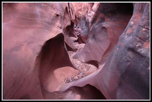
The Big West fork quickly slots up and remains a beautiful slot canyon for another mile. Be there when the sun is high for some beautiful glowing canyon walls.
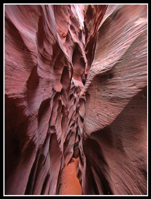 Big West fork narrows
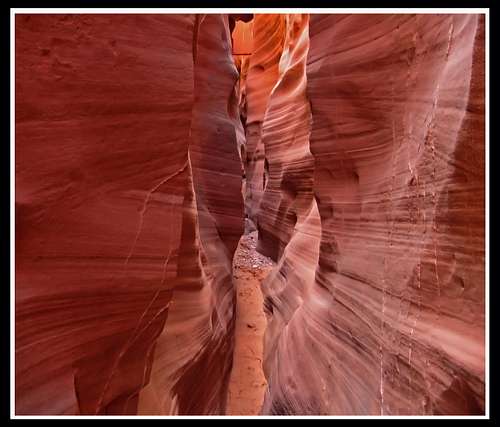 Big West Fork Narrows
This canyon does not require any technical gear although there are nine (9) chalkstones that will have to be climbed over that some people will need a boost from another person to get over. Therefore it's important to go in pairs. When we went, I was able to climb over all but one of the chalkstones and my partner was able to climb over all but one as well. If you are pretty tall, you will may need some help on one of the stones where as if you're shorter, a different one will give you some problems. Note that some people will likely have trouble making it up some of these obstacles so it is best to go with some canyoneering experience and are comfortable with some exposure! The canyon opens up and offers many escape routes on the right hand side.
Look for one and climb out the right side to the Carmel rim...enjoy the views as they are spectacular. For the return trip, you can either descend the Big West fork back to the Main fork back to your car. This would be recommended if you really enjoyed the slots you just went through. However if your a geology buff like me you may want to hike cross country on a sea of Navajo sandstone to see the Cosmic Ashtray. This is a large (about a football field in diameter) and deep (maybe 100 feet) hole in the ground among Navajo sandstone. There is also a rock island in the center. How this formed is completely unknown but I have my theories. Do not attempt to enter this large hole as the bottom is filled with deep sand and you will NOT be able to escape.
Only enter if you are prepared with rappelling gear and ascenders and know how to use them. You don't want to get stuck down there forever.I'll try and preserve this geologic wonders' secrecy and spare everyone the details on how to get there but in a nutshell follow these steps to complete the loop. After ascending out of the Big west fork, generally head in an eastward direction and cross over 1 major drainage. This drainage is the upper west fork of Red Breaks. Climb out and continue east and enter a second major drainage which is called the Northeast fork of Red Breaks. Follow this fork upstream and round a high point to the right. We climbed this high point and I shot this panorama of the Red Breaks area.
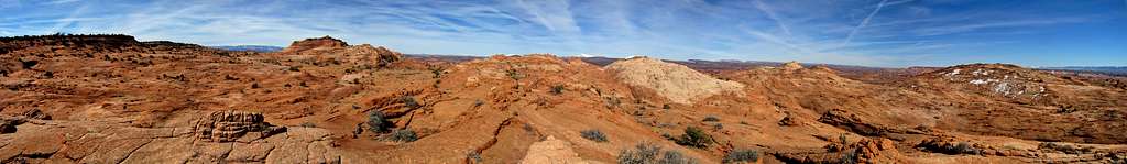 Red Breaks Panorama
This high point has coordinates:
37° 41.500' North
111° 19.610' West
Continue around this point and weave through many round Navajo hills and cross two minor drainages. Generally head in a southeast direction and after about a mile from the high point you will reach the cosmic ashtray.
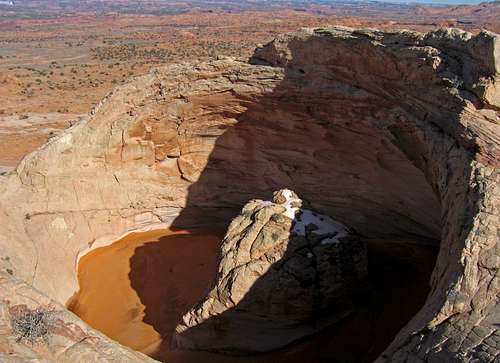 The Cosmic Ashtray
If you look closely you will see a person on the opposite rim of the cosmic ashtray in this photo. After you have had you fill of eye-watering, chin-dropping glory of this wonder, look down the hill to the southeast and you will see a road. This is the same road that crosses Harris Wash at the official trailhead so if you hike down to the road and turn RIGHT on it, you will return to Harris Wash and your car after 4.5 miles of walking on the road. This loop is about 15 miles and makes for a superb day hike. Ideally it would take an entire day but it can be done in a half day if you want to rush things (not recommended). It is one of my all time favorite day hikes I have ever done and with that, I request that anyone who goes here to please keep the area wild and pristine. I plan to return here and want to see the area the same way I did when I went the first time. Don't make me regret making this page! I had a good heart and felt it would be nice to share this beautiful area for solitude seekers looking for adventure.
Shown below is a map of the Red Breaks route I took with the main features labeled.
Camping/Red Tape
Since the area is in the Grand Staircase Escalante National Monument you should pick up a free permit to camp at the BLM office in Escalante.With this permit you can practically camp anywhere but don't camp in stream beds or dry washes. There is no red tape here as everything is on BLM lands. Please practice leave no trace.
External Links
Red Breaks - Slot Canyons of the American Southwest
Red Breaks - Todds Utah Desert Guide
Michael Kelseys book "Non-technical Canyon Hiking Guide to the Colorado Plateau" also had information about Red Breaks.
Bob Burd - Oct 5, 2013 7:39 pm - Voted 10/10
A very fine page!Matt, small correction: The correct spelling is "chockstones", not chalkstones or chokestones (as someone else used).
Matt Lemke - Oct 7, 2013 3:48 pm - Hasn't voted
Re: A very fine page!wow Bob thanks for pointing that out! Of all the times I have written that word it's probably spelled wrong every time. I'll fix as many as I can.