Why the trip, why the report?
I had wanted to do a day summit on Mount Whitney using the Mountaineer's Route since a previous overnight summit in March of 2009. Basically, that trip had gone so smoothly, I felt that with similar weather and a light day pack, summiting in a day would be very doable and a lot more fun. This was true for me on this day, with these conditions, and with my unintentional but very necessary training preparation before hand. I had summited Humphrey's Peak in Arizona about 6 times in the weeks prior to this, purely for fun. Also, February 6, 2011 was a certain sport's bowl day, and I would much rather miss that for a day in the mountains.
I decided to write this report almost 2 years after the February 6, 2011 summit because I have seen a number of fairly low ball reports on "winter summits" of Whitney, some boasting about the impressive nature of their winter summit, with next to zero snow in a dry December, or spending nights out on the mountain, going very slowly and really over doing it. Haul a heavy pack and spend 3 nights if you like, but the MR can be done in a day.
Still, my trip took no real skill and was nothing extremely special. The total time out was not even 16 1/2 hours, but still it was mostly nothing more than a long walk. My route required snowshoes, some endurance, and not much more, unless you consider using ice axes and kicking steps a special skill. I am far more impressed by SP user "SierraSkier" and his Skiing Denali 09 report.
The Trip
I drove to Lone Pine and spent the night in the Alabama Hills. This was a mistake, as it was very windy and I should have just stayed at the Hostel and spent the money for a good nights sleep. I think the wind died down around 2, and I had about 4 hours of rough sleep after that. I was up early, had breakfast in town, parked just above the first switchback on the road near 7200', and was hiking by 0715.
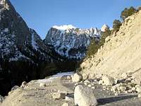
![Portal Road]() Shortly after beginning. On the Portal Road with some rock fall. I could have driven to this point were it not for the rocks.
Shortly after beginning. On the Portal Road with some rock fall. I could have driven to this point were it not for the rocks.![North Fork, Ledges at Right]() Ascending the North Fork, with the Ledges at right. Snow conditions were perfect.
Ascending the North Fork, with the Ledges at right. Snow conditions were perfect.
The snow was the best I had ever seen, and I moved fast, making UBSL in 3 1/2 hours. I stopped there to melt water and got to Iceberg in 5 3/4 hours. I was tired by this point, but I was on the summit in under 8 1/2 hours after beginning. I went pretty slow for the last couple of thousand feet when compared to my previous 5,000', but I feel that is reasonable. Just before starting up the last 400 feet, I met two guys who were basically doing what I had done, except they were real climbers. They had skied up from about 100' past my parking location, climbed the East Buttress, and were starting their descend down. I encountered their skis at Iceberg, and I suspect they made it down very fast after meeting up with their equipment.
![At Iceberg Lake]() Whitney while at Iceberg Lake. Climbers are just visible in the image.
Whitney while at Iceberg Lake. Climbers are just visible in the image.![Closer on the Climbers]() I think these guys are probably the ski climbers, not the San Diego Duo, as they are very close to the summit and I met the two skiers at the bottom of the final 400. The San Diego Duo arrived on the summit a little after I did.
I think these guys are probably the ski climbers, not the San Diego Duo, as they are very close to the summit and I met the two skiers at the bottom of the final 400. The San Diego Duo arrived on the summit a little after I did.
I spent an hour up on top, and met a Russian Guy from LA who was going to spend the night up there, and two other Climbers from San Diego (real climbers) who had come up the East Buttress that day. They had reason to do a multi-day trip with the long technical climb, and we both commented on how fast the ski-climbing party was. Me, I was happy just to make my accomplishment, but also knew I had to descend. Views were really great, and they were the best I ever had on Whitney. I was able to see further than before or after.
I went pretty slow descending the top 400 feet, especially the highest parts. I waited until after the two other climbers were below me, and used my own ice axe and a borrowed ice axe for descent. It probably wasn't necessary, but I felt a lot better with it. The snow was substantially thicker than my last summit almost 2 years before, and with the other guys having passed before me and their larger plastic boots, I had lost the pre-kicked boot tracks and had to do my own kick stepping to descend. Because of my boots, this put a lot of pressure on my feet and toes, and I ended up paying the price for that later on.
![Top of the Final 400]() On the summit after nearly 8 1/2 hours. Snow was great in the last 400' on this trip.
On the summit after nearly 8 1/2 hours. Snow was great in the last 400' on this trip.
I use(d) a winter boot intended for pedestrians, not a mountaineering boot. It is soft soled, and not made to accept a crampon. It's fine for snowshoes, and most people, but if you intend to mountaineer, I do not recommend it. I got around this by having cut grooves for my crampons to fit on the boot heel. Believe it or not, this actually worked perfectly well in most situations. When tightened down, I never had issues with the boots or crampons so long as my travel was not parallel to a slope. Without a hard shank, the sole bends and twists, and as a result, the boot bends a little when kicking, and can bend a lot when going across a slope. This has caused me to have to stop and reinstall or tighten my crampons several time. Fortunately, only while crossing slopes, never while traveling up or down, as the boot re-assumes it's original shape after the kick is completed. So, except for basic snowshoe hikes, or short crampon hikes, I won't be doing Whitney or any other mountains that require a real mountaineering boot. Still, this street approach worked twice for Whitney, and I found it a little funny when I would see people out in their newly purchased heavy duty mountaineering gear training for mountains like Denali. Hey, I would under do it, and they would over do it. You got to try your gear someplace, right?
I was perfectly fine getting down the Final 400 and caught the last light in the Notch. It was totally dark by Iceberg and I used my headlamp to descend the rest of the hike. I stopped with the two climbers from San Diego and enjoyed some tea with them, and kept on after that. By this time, I was mostly just tired from not sleeping the night before. I stopped a few times in the upper North Fork, laid down, shut off my head lamp and looked at the stars. It was a very clear night and they were beautiful. I had to fight falling asleep at some of those times.
![Last Light in the Notch]() Looking northwest just after sunset. Taken in the Notch.
Looking northwest just after sunset. Taken in the Notch.
I recall hiking down the North Fork to be a lot worse than I would have preferred. I wish I could ski! What was soft and yielding on the way up that morning was hard ice on descent, and my crampons were biting into the ice with a vengeance. This jammed my toes and really worked my leg muscles. It was probably the hardest part of the entire trip as far as lasting effects go.
![Mount San Antonio?]() I determined that this is a closeup of Mount San Antonio north of Los Angeles, and it is about 162 miles away.
I determined that this is a closeup of Mount San Antonio north of Los Angeles, and it is about 162 miles away.
I got back to my car after 16 1/2 hours of total time out, including the hour on the summit, and all of the other food and water breaks. Not super fast, but I was happy. I slept on the Portal Road and left the next morning.
![North]() North summit views. We don't really need anymore, but here are some anyway.
North summit views. We don't really need anymore, but here are some anyway. ![Lone Pine Peak to Charleston near Vegas]() Some great views to the southwest. On descend I could easily see Las Vegas, Nevada's light pool.
Some great views to the southwest. On descend I could easily see Las Vegas, Nevada's light pool. Death Valley: Right?
I went to Death Valley to relax there for a few days. It was nice. Snow to Palms in a matter of hours.
![Mesquite Dunes-Death Valley]() Relaxing in the sun on the Mesquite Dunes, Death Valley National Park.
Relaxing in the sun on the Mesquite Dunes, Death Valley National Park.
I happened to go in a break between a very wet December Pineapple Express,and what started up in late February and ran into April as a very wet winter. Snow was deep and perfect while I was out, I can only imagine how deep it was in March of that year.
After Thoughts
I suppose one reason I never wrote a report for almost two years, is because I got lucky, dam lucky, and I've pretty much always known that. As I mentioned earlier, I inadvertently trained for the trip by summiting Humphrey in Arizona many times in January, and I didn't even plan on this trip until a few days before I went. Also, the pagan gods were really smiling on me, the stars all aligned, and a star child was born. Because despite high wind the night before in the Alabama Hills, and high winds blowing snow off the peaks the day after, and lots of snow in December and later in the winter, I managed to have both ideal settled snow conditions which were deep and stable, but calm conditions on the summit. I don't remember there being any wind at all for the hour I was up there. Visibility was excellent, too, and it was almost warm for 14,500' at the beginning of February. Part of me is pretty sure, that if any one of these chips had fallen out of place, that this would not have been a successful outing.
I don't want people to think this was just a walk in the park. I had plenty of winter experience on a number of peaks and routes on the San Francisco Peaks near Flagstaff, AZ. I had done this route with successful summits twice, once in summer and once in winter, and it had been weeks since a storm of any significance. I'm not capable of doing a winter climb on a technical route with mixed conditions, but for me this was within my reach. The entire time I was out, I knew I would turn around if I needed to do so, and seriously considered doing so when it was getting late, despite just being 400 feet below the summit. I was successful, but things could have gone bad. Consider this if you want to try your own attempt.
Comments
No comments posted yet.