
-
 13349 Hits
-
 71.16% Score
-
 2 Votes
|
|
Mountain/Rock |
|---|---|
|
|
39.63767°N / 105.52934°W |
|
|
Clear Creek |
|
|
Hiking |
|
|
Summer, Fall |
|
|
9900 ft / 3018 m |
|
|
Overview
Captain Mountain is a small but visually prominent peak in the Mount Evans Wilderness Area. For prominence snobs, this peak won't cut it, as it has only 160' of prominence above its highest connecting saddle with its parent peak, Rogers Peak. While it doesn't tower in the sky by itself, it is a wonderful hike in an area usually either closed to access, or extremely limited in use. With a slightly higher neighbor that is also a short bushwhack from the nice trail, Porcupine Hill to the NW (just off the Captain Mountain trail as well), this peak is ripe in its lack of visitors. Indeed, it is unlikely you will see anyone on the nice little trail, and even more unlikely you will see anyone on its nice little blocky summit, replete with water pockets. With a nice little trail to get you to within .25 mile of the summit, is a fine journey in a wonderfully remote-feeling place.Captain Mountain:
Elevation : 9,900' (interpolation)
County : Clear Creek
Quad : Idaho Springs
Saddle : 9,740'
![Trailhead sign]()
Signage for the Mt. Evans Wilderness area and the Captain Mountain trail.
County : Clear Creek
Quad : Idaho Springs
Coordinates : 39.6377°N, 105.5296°W
Rise : 160'Saddle : 9,740'
Getting There
From Denver, take I-70 west to the Evergreen (CO-74) exit. Follow the road west and then south until it takes a big left (east) toward downtown Evergreen. Go straight at the exit toward Evergreen Lake instead, then turn right at the stop sign. Follow Upper Bear Creek Road (CR 480) west. Drive to the lower TH/gate after the closure or drive to the Captain Mountain TH before the closure. Be sure to follow all traffic signals, signs, and speed limits. Lots of speed limit changes, and elk are frequent crossers of all those roads once you depart I-70.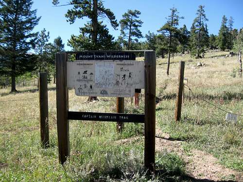
Signage for the Mt. Evans Wilderness area and the Captain Mountain trail.
Route
Hike or drive Upper Bear Creek Road (CR480) to the Captain Mountain trailhead. After filling out the Wilderness Area permit, take trail #46 northwest to the saddle area of Captain Mountain. A short bushwhack (.3 mile) takes you north from the trail to the summit area.While you are hiking or driving along the road, you will also see informational signs along the roadsides, describing tree removals, aspen groves, and other flora and fauna.
![Trail topo file]()
Trail from the lower trailhead.
![Closure signage]()
Signage stating the closure dates at the lower parking/trailhead.
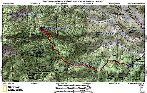
Trail from the lower trailhead.
As shown, this route takes about 11 miles and involves about 2,150' of gain round trip.
From the upper trailhead, it is just over 6 miles and about 1,300' of gain round trip.
Red Tape
Access is restricted seasonally. Mt. Evans road (upper access) closes typically around October 24th, depending on weather. The lower access, Upper Bear Creek Road, closes from Labor Day to 6.14 of the following year, and the entire area closes from 1.1 to 6.14 to ALL access. So if you want to drive to the Captain Mountain trailhead (instead of hiking the road), your window is 6.14 to Labor Day of each year.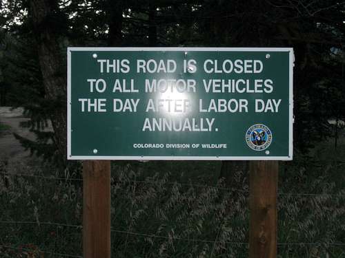
Signage stating the closure dates at the lower parking/trailhead.
When to Climb
Access is seasonally restricted. Your only opportunities to climb Captain Mountain (and also Porcupine Hill above Captain) occur from 6.14 until the end of the year (12.31). The best time of year for solutide and colors is late September or early October. You will have more company but probably awfully nice temperatures in June.Camping
There is camping available seasonally (summer) in the area at the Camp Rock campground (closed from Labor Day until 6.14 of the following year). While the area is open, you can also hike and camp in the Mt. Evans Wilderness area with the permit filled out.External Links
Captain Mountain on ListsofJohn.com.A nice little trail map on MountEvans.com.