
-
 25616 Hits
-
 88.19% Score
-
 26 Votes
|
|
Mountain/Rock |
|---|---|
|
|
39.61560°N / 105.6176°W |
|
|
Clear Creek |
|
|
Hiking |
|
|
Spring, Summer, Fall |
|
|
13391 ft / 4082 m |
|
|
Overview
 Sky Pilot and Alpine Cinquefoil, Rogers Peak
27 Jul 2008
A shy mountain residing northeast of Mount Evans (14,265 ft.), Rogers Peak is surely overlooked by many. Drivers on Mount Evans road speed by Rogers Peak, engines whining in the thin air, en route to the top of Mount Evans. Hikers departing Summit Lake for the Mount Spalding-Mount Evans circuit cast a glance at Rogers Peak over their right shoulder before beginning up Spalding’s east-facing ridge. Intrepid hikers plugging along their route from Echo Lake have not the time nor energy for Rogers Peak. Meanwhile, those pressed for time may steal a quick summit of nearby Mount Warren, but do not bother to push on to the summit of Rogers Peak.
Those who do make their way to the top of Rogers Peak find a quiet, lonesome summit standing in odd juxtaposition to the tourism-heavy atmosphere lingering around Mount Evans. A short, fun and rocky summit scramble over large broken blocks brings the hiker to a large and broad summit area capped by an up tilted final summit boulder begging the bold to strike the perfect Captain Morgan pose. Rogers Peak, so close to Mount Evans Road, yet so far from the crowds and chaos feels a bit like a well-kept secret sitting out in plain view.
Colorado Rank: 325th highest mountain in CO
Colorado 13ers Rank: 272nd highest 13er in CO
Mountain Range: Front
Prominence: Approximately 515 ft.
USGS Quad: Harris Park
Trails Illustrated Map: #104
Getting There & Route Overview
Rogers Peak shares the Mount Evans Wilderness with nearby neighbors Mount Evans, Mount Spalding, Gray Wolf Mountain, Epaulet Mountain and Mount Warren.- From I-70: Take Exit 240 in Idaho Springs. Follow Colorado Highway 103 (also called Squaw Pass Road) south to Echo Lake and Colorado Highway 5 (Mount Evans Road).
- From Bergen Park: Take Colorado Highway 103 (Squaw Pass Road) west to Echo Lake and Colorado Highway 5 (Mount Evans Road).
| Route | Approximate Mileage | Approximate Elevation Gain | Special Note | Driving Directions |
|---|---|---|---|---|
| Summit Lake | 3.5 miles roundtrip | 557 ft. | Includes a warm-up summit of Mt. Warren (13,307 ft.) | From Echo Lake, ascend Mount Evans Road. Just before mile marker 10 is Summit Lake. Turn right into the parking area. |
| Mount Goliath | 5 miles roundtrip | 1,710 ft. | Includes an optional summit of Goliath Peak (12,216 ft.) | From Echo Lake, ascend Mount Evans Road. Park at the Lowe Goliath Trailhead at the Goliath Peak Nature Center. |
| Echo Lake | 8 miles roundtrip | 2,794 ft. | Takes the hiker into the lower reaches of Chicago Lakes basin | Just west on Hwy 103 of the intersection with Hwy 5, park at Echo Lake. |
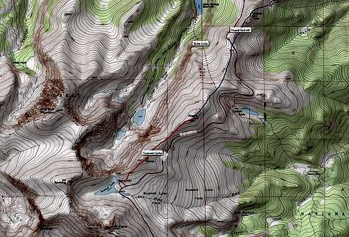 Click on map for larger view
Red Tape
 Typical scrambling conditions found on Rogers Peak.
27 Jul 2008
 Looking towards Mount Evans (14,265 ft.) and Mount Spalding (13,842 ft.) from the summit plateau of Rogers Peak.
27 Jul 2008
• There is an amenity fee ($10.00 per vehicle for day use) to visit the Mount Evans Recreation area.
• Area. Follow LNT (Leave No Trace) principles.
Camping & Lodging
 Rogers Peak from saddle
with Mount Warren (13,307 ft).
27 Jul 2008
 The uplifted summit boulder of Rogers Peak.
27 Jul 2008
Day visitors from the Denver area and even Ft. Collins and Colorado Springs may find lodging unnecessary.
Nearby campsites
- Echo Lake Campground at the intersection of Hwy 103 and Hwy 5
- West Chicago Creek Campground at the Hells Hole Trailhead at the end of Route 114 off Hwy 103.
Hotels
The town of Idaho Springs, at I—70 and Hwy 103, offers a variety of inns, B&Bs and motor lodges. Those who like to soak in hot springs after their hike may wish to explore Indian Hot Springs.
Weather & Seasons
The Mount Evans Road is typically open between the U.S. holidays of Memorial Day and Labor Day. This translates roughly into the last weekend in May through the first weekend in September. The road may be open to Summit Lake slightly earlier in the spring and slightly later in the fall than is the road to the summit of Mount Evans.The approach from Echo Lake via Chicago Lakes basin should be approached with caution during snow season due to avalanche risk.
External Links
 Rogers Peak from Mount Warren summit plateau.
27 Jul 2008
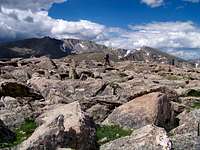
 Rocky summit plateau of Rogers Peak.
27 Jul 2008
Mount Evans Scenic Byway & Wilderness
Clear Creek Ranger District (Voice: 303-567-3000)