
-
 21964 Hits
-
 85.87% Score
-
 21 Votes
|
|
Mountain/Rock |
|---|---|
|
|
39.74548°N / 105.80052°W |
|
|
Hiking, Mountaineering, Sport Climbing |
|
|
Spring, Summer, Fall, Winter |
|
|
13362 ft / 4073 m |
|
|
Overview

Colorado Rank #349
Topo Map:
Grays Peak 39105-F7 1:24,000
Prominence:
Clean Prominence: 522 ft/159 m
Optimistic Prominence: 562 ft/171 m
Key Col: 12,840 ft/3914 m (40 foot contour)
Col elevation in range between 12,800 and 12,840 feet.
Topo Map: Grays Peak 39105-F7 1:24,000
Topo Map:
Grays Peak 39105-F7 1:24,000
Prominence:
Clean Prominence: 522 ft/159 m
Optimistic Prominence: 562 ft/171 m
Key Col: 12,840 ft/3914 m (40 foot contour)
Col elevation in range between 12,800 and 12,840 feet.
Topo Map: Grays Peak 39105-F7 1:24,000
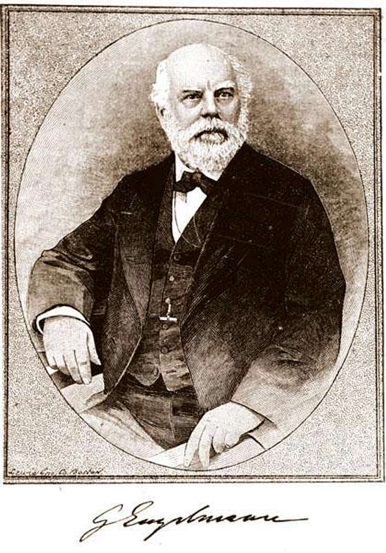
Engelmann Peak (or Crater Mountain) Engelmann Peak sits in Clear Creek County and can be seen from several places along US Highway 40. The U. S. Geological Survey (USGS) has given it a Latitude of 39˚44’44”N and a Longitude of 105˚48’02”W with an elevation of 13,376 feet. The website 13ers.com shows the elevation as 13, 362 ft and lists its rank as 349 of 637 in the State and 25 of 59 in the Front Range. The mountain is named for George Engelmann (1809-1884) a famous botanist responsible for describing and naming flora inthe Rocky Mountains. He was born and educated in Germany and received his medical degree there. In 1832, he sailed to America. Hisfinancial backing had come from relatives in Germany who wanted him to invest in the lands of the new country so he explored areas in Illinois, Missouri and Arkansas.He completed his business transactions for his family in 1835, at which time he moved to St. Louis and began his medical practice. He would also continue his botanical studiesand collections which would be a life long passion. In 1840, he would return toGermany to marry his cousin,and then both would return to the United States,landing in New York City.Here during this stop, he would meet Asa Gray, an already famous botanist, andtheir friendship would last until Dr. Engelmann died. As he grew older, moreand more of his time was spent with his botanical collection, which contained many original specimens of western plants that he had named and described. Someof these specimens had been collected by C. C. Parry, another botanist, whospent several years in Clear Creek County collecting flora specimens for Dr. Engelmann and Dr. Gray. Dr. Christopher C.Parry would name this mountain for his friend, George Engelmann. The Engelmann spruce was also named for him.Dr. C. C. Parry wrote in the American Journal of Science and Arts, 2nd Series, Vol. XXXIII. No.97, of January, 1862 the following… “In my solitary wanderings over these rugged rocks and through these alpine meadows,resting at noon-day in some sunny nook, overlooking waters of snow and crystal lakes girdled with midsummer ice, I naturally associate some oft he more prominent mountain peaks with distant and valued friends. To two twin peaks always conspicuous whenever a sufficient elevation was attained, I applied the names ofTorrey and Gray; to an associated peak, a little less elevated but in other respects quite as remarkable in its peculiar situation and alpine features, I apply the name of Mount Engelmann.”In the book, The Saga of Upper Clear Creek by Erl H. Ellisand Carrie Scott Ellis, published in 1983, they write: “It is stressed that the authors believe that this is the mountain that Parry named Engelmann in 1861.”They would be referring to the mountain Kelso that is connected to Torrey’sPeak. Visitors passing the Bakerville Exit on Interstate 70 often assume that they are seeing Grays and Torrey as they pass by. Grays is not visible, the mountain they are seeing is Kelso. In checking the USGS Geographic Names Information System(GNIS) decision card for Mount Sniktau (a mountain located near Eisenhower Tunnel on Interstate 70), it reads “Said to have been so named in the (18)60’sby Prof. Parry, after Prof. Engelmann. The Geo. Bd. on recommendation of the Colorado Geog. Bd. gave the name Engelmann to another peak 6 mi. N. W. of this.Map of Clear Creek Co. by P. P. Barbour, Engr. 1924” This card is dated June24, 1925 and also list other names as “Big Professor” which would fit the historic description of Dr. Engelmann.To add to the confusion, the USGS decision card for Engelmann Peak is dated August 5, 1912 and itreads… “Believed to be the Mtn so named by Dr. Parry” The card also lists“Local usage” as “Cowles Mtn”. Henry DeWitt Clinton Cowles was an important early leader of Empire, Colorado.Refer to P. P. Barbour, 1924 map. It shows Engelman (one“n”) where Mount Sniktau now is and Cowles Mt.where Engelmann Peak is now.
![Unnamed Image]()
George Engelmann (1809-1884)
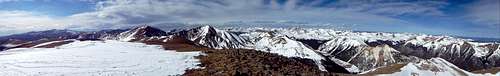
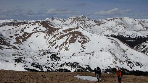
![Panorama from top of Engelmann Peak]()
Panorama from top of Engelmann Peak
Directions to the Trailhead:
On US-40, drive 7.4 miles west from Main Street in Empire toward Berthoud Pass or drive 5.9 miles south of Berthoud Pass. Turn left at the bend in the road, following the road toward the Henderson Mine. Pass the Big Bend Picnic Ground. After 0.4 miles from US-40, take the left fork toward the old Urad Mine. This road becomes unpaved. After 0.9 miles from the fork, park off the road at the spacious flat area.
George Engelmann (1809-1884)
Getting There
Panorama from top of Engelmann Peak
On US-40, drive 7.4 miles west from Main Street in Empire toward Berthoud Pass or drive 5.9 miles south of Berthoud Pass. Turn left at the bend in the road, following the road toward the Henderson Mine. Pass the Big Bend Picnic Ground. After 0.4 miles from US-40, take the left fork toward the old Urad Mine. This road becomes unpaved. After 0.9 miles from the fork, park off the road at the spacious flat area.

Locked Fence
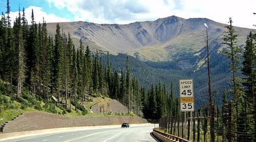
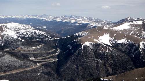
Berthoud Pass
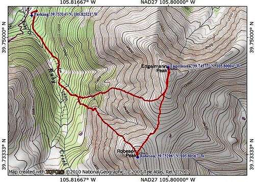
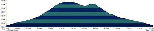
The Hike

On the trail
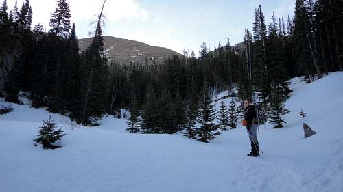
Hiking Engelmann Peak
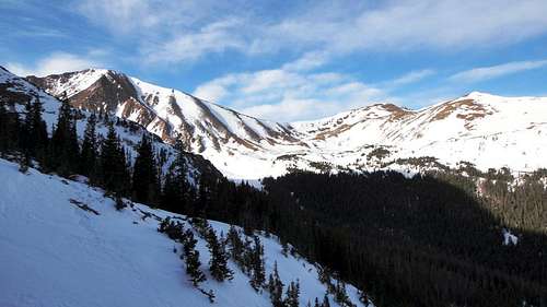
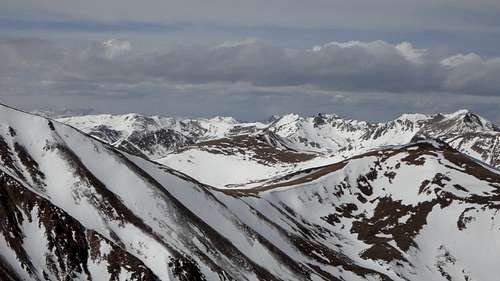
Views
The Hike:
Proceed due east, over grass and rock above atailings pond. Enter the trees, ascending steeply to the east, until you gain aridge below timberline. Turn right (south) on this ridge and continue to ascendpast timberline to another ridge. From here Engelmann summit becomes visible.This is all steep going, but footing is firm. Continue south over tundra to atalus slope, where there is a faint trail to the top of Engelmann Peak.
A small cairn is the only marking.
Continue south for a mile to Robeson Peak,mostly over tundra. Lose about 560 ft to the saddle and than ascend 340 feet tothe flat, unmarked top of Robeson Peak.
Descend:
To descend return to the saddle and than passdownward and west into chute of scree and talus. A creek begins in this chute.Follow the creek to an abandoned mine bellow timberline.
A trail begins here and continues west and northuntil it meets an old mining road running parallel to Ruby Creek. Turn rightonto this mining road, until it ends at a locked fence.
Closer to the summit.
Views from slopes.
Berthoud Pass from summit.
Red Tape
Clear Creek Tourism Bureau
PO Box 100, Idaho Springs 80452
(303) 567-4660 or (866) 674-9237
Georgetown VisitorsCenter
1491 Argentine St, Georgetown 80444
(303) 569-2405
Idaho Springs Visitors Center
2060 Miner St, Idaho Springs 80452
(303) 567-4382
Clear Creek CountyFact Sheet
Location:
P.O. Box 100, Idaho Springs, CO 80452
Clear Creek CountyTourism Bureau
Phone: (303) 567-4660
Toll-Free: (866) 674-9237
office@clearcreekcounty.org
Information: www.clearcreekcounty.org
Description:
Clear Creek County is located just 20 miles west of Denver along the I-70 corridor and encompasses the communities of Idaho Springs, Dumont, Downieville,Lawson, Empire, Georgetown and Silver Plume.
This mountain gem is where the historic west meets new adventure. Here is where the first gold strike took place. Visit working mine sand pan for gold; explore the historic Victorian mining towns of Georgetown, Idaho Springs, Silver Plume and Empire; or take a trip back in time on the historic Georgetown Loop Railroad®. Clear Creek County is also where you can get your adventure on! From hiking, biking, rafting,fishing, skiing and zip lining to scenic byways, 14,000-ft. peaks (14’ers), the highest paved road in the Americas and wildlife viewing, there’s something for every level of adventure.
You’ll also find unique lodging, dining and shopping experiences in a stunning mountain setting.
Historic Towns:
Created as a result of George Andrew Jackson’s discovery of gold on January 7, 1859, Clear Creek County is one of the original 17 designated state counties and one of the three counties in the state with its original boundaries still intact. In April 1859, groups of miners flocked to the area which was first known as Jackson’s Diggings, Sacramento City and Idahoe. In June of 1859, the area was formally organized, the first recorded in Colorado history. At that time, 400 people lived in the settlement. It later became known as Idaho Springs.
As more miners continued to move into the area, the prospecting moved west, following Clear Creek which runs most of the length of the county. Eventually the towns of Dumont, Downieville, Lawson, Empire, Georgetown and Silver Plume were established. In 1867, the Colorado Legislature called as pecial election and the county seat was moved from Idaho Springs to Georgetown. Today Clear Creek is a diverse destination where visitors can step back in time,wander the historic mining towns, explore museums and gold mines, and enjoy a wide range of outdoor activities.
Weather:
Weather in Clear Creek County is fairly moderate and can vary drastically depending on where you are. In summer, the day temperature ranges from 60-80 degrees with an average of 300 days of sunshine. In winter, the day temperature ranges from 20-45 degrees with an average snowfall ranging from 70 inches in lower lying areas to 400 inches at Loveland Ski Resort.
Seasons:
Summer: It’s high season in Colorado, which means it’s time to get outdoors and recreate! Clear Creek County is a virtual outdoor playground with a multitude of recreational opportunities as well as attractions.
Visitors can explore hundreds of hiking and biking trails;cast a line and fish; climb a 14,000-ft peak; ride the Georgetown Loop Railroad®, an authentic narrow gauge train that runs between Georgetown and Silver Plume; zip line across or raft Clear Creek; discover gold while panning at a real mine; explore historic mining towns; take in stunning views while driving along a national scenic byway; or simply camp out with the family!
Fall: When the aspens turn from green to shimmering gold it’s a great time for a hike, ATV ride or horseback ride in the mountains.Visitors can take in the fall foliage with a ride on the historic Georgetown Loop Railroad® or drive along a scenic byway. It’s also hunting season. Whether hunting with a rifle or bow visitors can search for big game such as elk, deer and small games such as turkey, Ptarmigan and Grouse.
Winter: As the snow begins to fall and blanket the Rocky Mountains, Colorado’s arid climate produces some of the world’s best powder for snow sports such as skiing,snowboarding, snowshoeing, snowmobiling, sledding, ice-fishing, ATVing, hot springs, and nature viewing.
Clear Creek County is home to one of the oldest ski areas in Colorado, Loveland Ski area and one of the newest, Echo Mountain. Visitors can experience all types of skiing (from downhill, and cross-country to snowboarding and telemark); explore high-country trails for snowmobiling,cross-country skiing, and snowshoeing; ice-fish on Georgetown Lake or simply relax in the hot springs at Indian Hot Springs.
External Links
Maps
View Larger Map
redsplashman23 - Aug 27, 2014 10:09 am - Voted 10/10
CoordinatesThe Coordinates for Engelmann Peak are 39.7455°N, 105.8006°W. Your coordinates put it next to Bobtail Benchmark by Jones Pass.