
-
 9613 Hits
-
 84.27% Score
-
 18 Votes
|
|
Mountain/Rock |
|---|---|
|
|
39.61276°N / 105.82629°W |
|
|
Summit County |
|
|
Hiking, Mountaineering |
|
|
Spring, Summer, Fall, Winter |
|
|
12792 ft / 3899 m |
|
|
Overview
Cooper Mountain
Elevation: 12792 ft / 3899 m
Front Range, Colorado
Unranked
USGS Quad:Montezuma, CO, Grays Peak, CO
Cooper Mountain is nice little peak, named and recognized by USGS, but because of its lack of prominence (less than a 300 foot drop in the connecting saddle, etc.) it’s unranked peak. This Cooper Mountain is not to be confused with Copper Mountain ski resort in Summit County. Cooper Mountain is great combo hike with Ruby Mountain, and it can be climb year around.
 |
 |
 |
Getting There
How to Get There:
Driving Directions
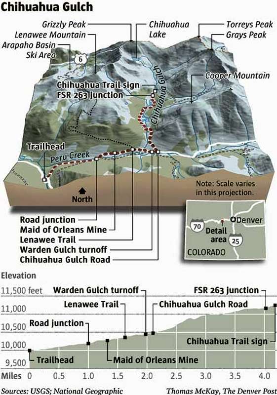
From Denver, take I-70 to theexit for Highway 6 (Loveland Pass) just before theEisenhower Tunnel. When you get to Keystone, follow signs to Montezuma Road. The trailhead for PeruCreek is on the left, 4.5 miles up Montezuma Road. Follow this trail a little over two miles inuntil you see the sign and trailhead for Chihuahua Gulch on the left.
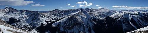 Summit Panorama
Route
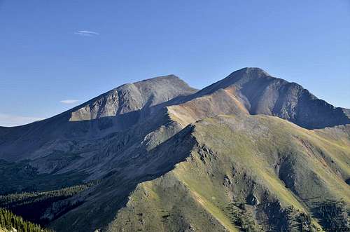
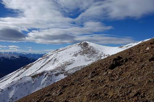
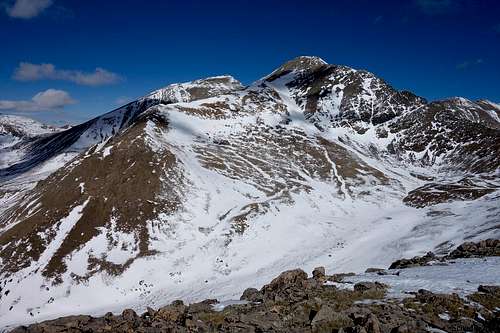
Cooper Mt with two 14ers in background.
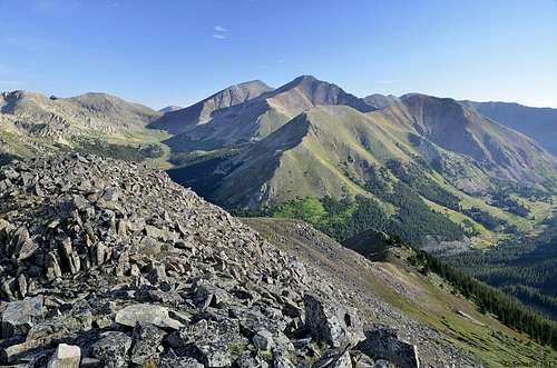
Cooper Mt. from Morgan Peak.
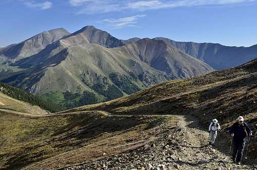 Cooper Mt in background
Before You Go:
This area contains a lot of private land;so observe and respect all “NO TRESPASSING
Chihuahua Gulch
Directions: Head East from Dillon on U.S.6 and pass Keystone Lodge. Turn right on to Montezuma Rd. then left at the fork and continue for just over 4 and one half miles to Peru Creek Rd. on your left. Turn left onto Peru Creek Rd.and continue for about 2 miles on this rough (it usually can be done w/o four wheel drive) road to the Chihuahua 4WD road on your left. Park along the road and start your hike at the 4WD road.This 6 and a half mile round trip hike is characterized by awesome 360 degree views and a trek to a lake, frozen for most of the year, at the base of 13,427' Grizzly Peak. Beginning on a 4WD road this hike features a climb of varying intensity that culminates in a steep scramble up a grass and talus slope to the lake at 12,200' which is located directly west (left) of the trail as you reach the end of the gulch.
Views of 14'ers Gray and Torreys to the East make the walk through the beautiful meadows especially rewarding. Since there are several stream crossings and some marshy terrain you might want to save this hike for the dry season. Fall is an especially great time to enjoy this invigorating adventure as the splendor of the Aspens in the lower section of the trail will demonstrate.
Peru Creek Trail:
This trail offers amazing scenery, gorgeous hiking trailsand access to other spur roads, all without being very difficult for most SUVsto access. It really is a showcase for the best scenery in this area of Colorado.
It starts at a parking area just off of the pavement before you get to Montezuma. There is a break in a fence where you start the trail. It is a fairly mellow road with plenty of room to pass other vehicles. Expect to see passenger cars on this road as well, though an SUV with good clearance is recommended.
The first trail instersection is Warden Gulch on the right, two miles from the Peru Creek trailhead. It is marked by a very visible sign.
The next intersection is about 700 feet later on the left, the maintained trail of Chihuahua Gulch. This trail is quite a bit more difficult than Peru Creek.
Continue on and in less than two miles you will see the intersection with Cinnamon Gulch on the right. This trail is worth exploring if you have an SUV with good clearance, and if you don't go past the mines you will not have any trouble at all.
Continue on Peru Creek and in 4.6 miles you will reach the Anderson Tunnel Mine that is right next to the trail. The Shoe Basin Mine is just above it on the left. There is a cabin to the right of the trail, and a parking area just before the mines on the left. There is also a gate across the road marking the end of the 4x4 trail.
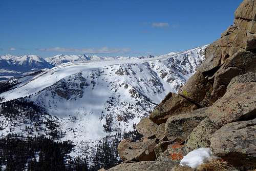
Ridge from the Peru Creek Raod.
Climbing the ridge.
 Greys Peak from the ridge.
Soutwest Ridge:
From the trailhead, hike along the road as it climbs gentlynortheast, then east into the Peru Creek valley. Stay on the main road at mile1 as it drops down and crosses the drainage before continuing along the northside of the creek. Due to the drier-than-usual conditions so far this season,sections of the road may be covered with ice flows. Exercise caution whencrossing these areas; the ice may be covered up by future snowfall.
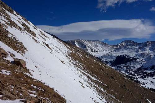
Pass the Maid of Orleans Mine buildings at mile 1.3 andcontinue past the start of the Lenawee Trail at mile 1.6. You will pass theturnoff to Warden Gulch at mile 2, shortly before the start of the ChihuahuaGulch road at mile 2.1. If you are going to hike Cooper Mountainsouthwest ridge this is good point to leave Peru Creek road, and startbushwhacking to your left side. Terrain here is not pleasant, far from that,its very steep,
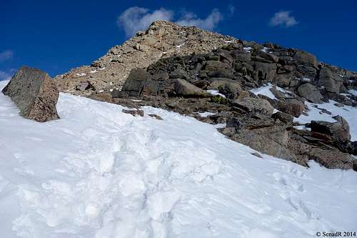
and with snow its even harder and steeper. This where yourendurance and perseverance comes to light. Once you are above timber linethings are more than obvious, find the easiest way to gain ridge, and followridge all the way to the summit of Copper Mountain.
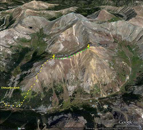
From Ruby Mountain:
This is probably easiest and most convenient wayto tag Cooper Mountaintogether with Ruby Mountain.
Red Tape
There is no red tape concerning fees or permits, but do respect private property in the area.
There are no developed campgrounds along the Peru Creek Road, but there are numerous opportunities for dispersed roadside camping.
Contact White River National Forest for more information, including gate openings/closures for the Peru Creek Road. Phone number: 970-945-2521.
When to Climb
External Links
Trip Reports: