
-
 1896 Hits
-
 83.69% Score
-
 17 Votes
|
|
Mountain/Rock |
|---|---|
|
|
45.67074°N / 7.78368°E |
|
|
9012 ft / 2747 m |
|
|
Overview
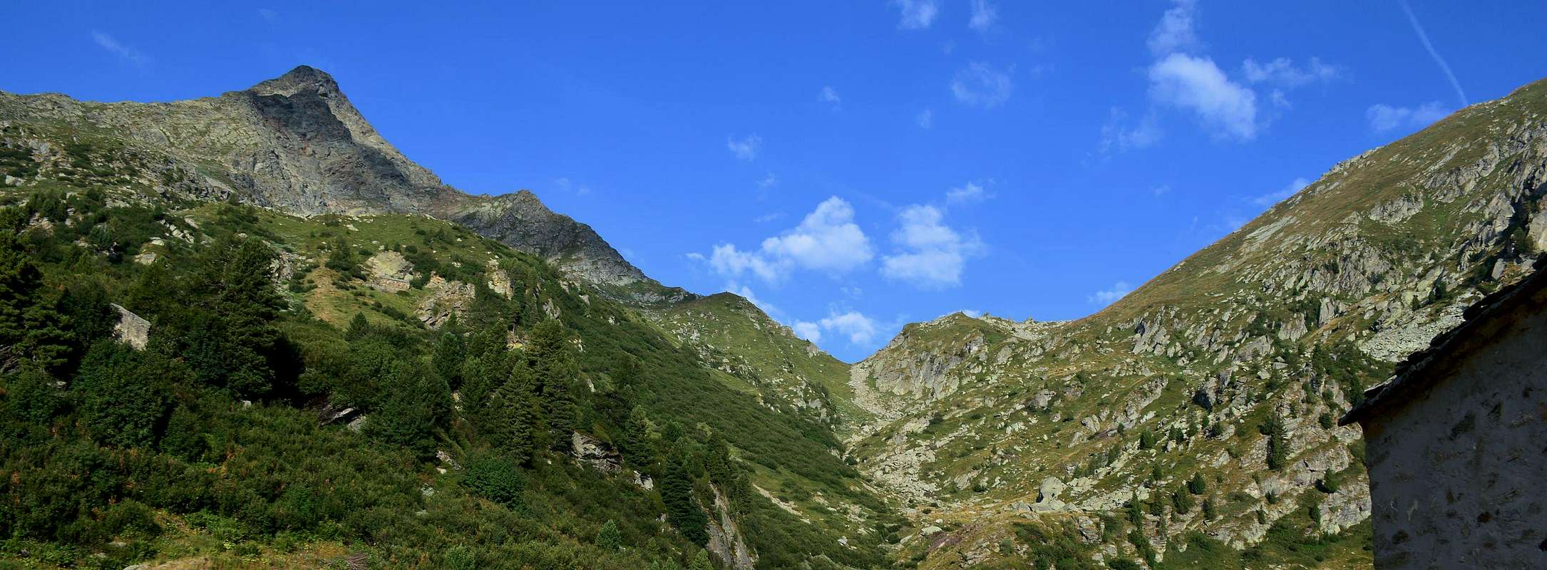
This Summit is placed between the Valley of Ayas and Gressoney or Lys and more precisely between Becca Torché, above the Col Dondeuil (2.372m), and the Mont Crabun. A summit that "suffers" competition of the nearby pyramids of Torché and Becca di Vlou but that is imposed on the Southern slope towards the Dora Baltea in the Central Valley. It has the dual placename of Corno del Lago (Horn Lake) and "Bec des Allemands', because, after the passage of Napoleon with 2000 soldiers May 20th, 1800, was later guarded by the Austro-Russian troops who garrisoned fortifications, today existing, now to the South of the hill, this last known also to Issime with the name of "Munes Pass or Mahdokht Step". This demonstrates that this whole area was frequented, after the Salassians People, by the Walser Population (of German origin) and into the Valley of Challand than that of Lys. This is a different version of the name than militaristic, which implies that the town was well known from the ancient populations, through Dondeuil, went from Issime Challand-St-Victor then dropped to Verrès and Saint Vincent with purposes commercial. Without this premise, we must add that the term of Corno del Lago comes from the series of lakes (2.271m) located to its Eastern slopes, where its Southern Crest declines towards the Mont Crabun (2.710m). Another two ridges descending to the Southwest in the direction of the Monte dell'Aquila (Eagle Mount; 2.580m) and towards the North over the Colle Dondeuil before of two "Dames de Challand". The first two contain the "Valeille de Prapenous", while the third is the border between the Valley of Dondeuil (West) from that of Scheity above Fontainemore/Issime in the Gressoney Valley. The slopes are very steep (especially the West) and then totally inadvisable, while exist a small track along the Northern Ridge. Beautiful views of the southern slope of the "Dames de Challand", the neighboring valleys and in South to the Eastern sector of Graian Alps.
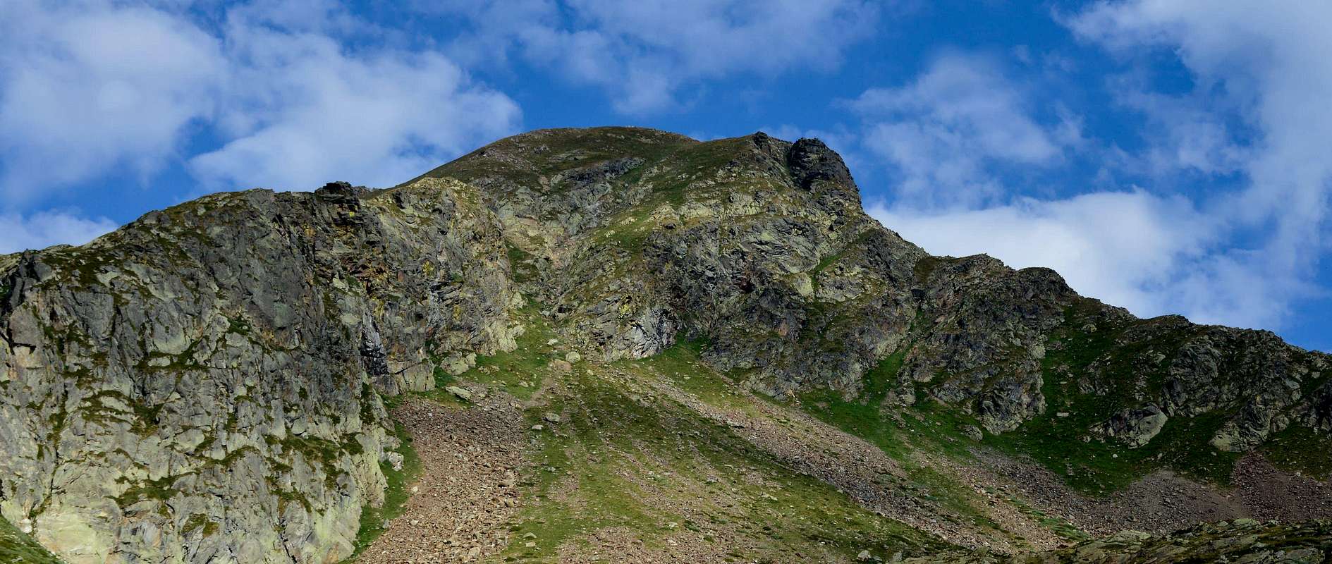 |
Questa Cima si trova collocata tra la Valle di Ayas e quella di Gressoney o del Lys e più precisamente tra la Becca Torché, soprastante il Colle Dondeuil (2.372 m), ed il Mont Crabun. Una Vetta che "patisce" la concorrenza delle vicine piramidi della torchi e della Becca di Vlou ma che si impone sul Versante Meridionale verso il corso della Dora Baltea nella Valle Centrale. Possiede la duplice denominazione di Corno del Lago e di "Bec des Allemands", poiché, dopo il passaggio di Napoleone con 2000 soldati il 20 Maggio 1800, in seguito venne presidiato dalle truppe austro-russe che lo presidiarono con fortificazioni oggigiorno esistenti subito a Meridione del colle, questo ultimo conosciuto ad Issime anche con il toponimo di "Passo di Munes". Questo a dimostrazione che tutta questa area era frequentata, dopo i Salassi, dalla Popolazione Walzer (di origine tedesca) sia verso la Valle di Challand che quella del Lys. Questa una versione differente del nome rispetto a quella militaresca, che fa comprendere come la località era ben conosciuta dalle antiche popolazioni che, attraverso il Colle del Dondeuil, si recavano dal Comune d'Issime a quello di Challand-St.-Victor per poi scendere a Verrès e Saint Vincent con scopi commerciali. Fatta questa doverosa premessa, bisogna aggiungere che il termine di Corno del Lago deriva da quella serie di laghetti (2.271 m) posizionati alle sue pendici Orientali, dove la sua Cresta Meridionale declina verso il Mont Crabun (2.710 m). Altre due creste scendono verso Sudovest in direzione del Monte dell'Aquila (2.580 m) e verso Settentrione sopra il Colle Dondeuil prima delle due "Dames de Challand". Le prime due contengono la "Valeille de Prapenous", mentre la terza costituisce lo spartiacque tra il Vallone del Dondeuil (ad Ovest) da quello di Scheity sopra Fontainemore/Issime in Valle di Gressoney. I versanti sono alquanto dirupati (soprattutto quello Occidentale) e quindi del tutto sconsigliabili nonché pericolosi, mentre una piccola traccia percorre la Cresta Nord aggirando qualche tratto. Belle vedute sul Versante Meridionale delle "Dames de Challand", sulle limitrofe valli nonché a sud verso il settore Orientale delle Alpi Graie.
First Ascents
- First on the Summit: Unknown.
- In winter: Unknown.
- Complete Traverse Becca Torché-Mont de Dondeuil-Gendarme du Dondeuil-Pic des Allemands-Mont Crabun: Osvaldo Cardellina and Giuseppe Lamazzi (this last exclusively Becca Torché), (Aug 18th,1996), from Dondeuil Alp and Pass and through Nort-northwest Ridge.
Getting There
BY CAR:
- From Torino, Milano, etc: Motorway A5. Exit at Ivrea or Quincinetto (Piemonte).
- From France: through the Mont Blanc Tunnel to Entrèves/Courmayeur. By Little Saint Bernard Pass, closed since November until half May to La Thuile Valley - Pré Saint Didier - Aosta - Verrès Municipalities. It is not necessary to take Motorway A5: you can drive on SR.26, in the direction of Aosta - Ivrea – Torino.
- From Ivrea Town: in West towards Pont Saint Martin, Verrès Municipalities in East from Aosta Town until Verrès and pont Saint Martin. From these Commons up to the Challand Saint Victor or Issime communes.
- From Courmayeur Resort: in East-southeast to Morgex, Aosta, St. Vincent, Verrès and Pont Saint Martin Municipalities.
BY PLANE:
- Aeroporto "Corrado Gex" Saint Christophe (Aosta).
Approaches and Route
A) - through Dondeuil e: departing from the Alps Dondeuil (having permission to take the private road by car), or, starting from Isollaz, with the full path of entire vallon. In this case, "resurfaces" an old way of going to the mountains with a nice "grind" that requires good hocks and a good dose of patience. In any case, it is beautiful, pleasant and scenic trip.
A) - dal Vallone del Dondeuil: in partenza dalle Alpi Dondeuil (avendo il permesso di prendere la strada privata in auto), o, a partire dal Isollaz, con il percorso completo di tutto il Vallone del Dondeuil. In questo caso, "riemerge" un vecchio modo di andare in montagna con una bella "sfacchinata", richiedente più che buoni garretti ed una buona dose di pazienza. In ogni caso, è un bel, piacevole e panoramico viaggio.
 |
 |
 |
 |
 |
B) - Approach by Issime Commune: reached Issime (953/80m; the Church of San Giacomo) with a short detour from the regional road for the Gressoney Valley, take the path n° 1/Via Alpina that rises to the West-northwest in the direction of the Vallon of Valbona. The same, after a first series of hairpin bends reaches Santa Margherita, where comes the farm road. A long diagonal passing through the Alps Zeuin, Lamatta (1.787m), vain, Vieukie, Methia, Mongiovetta salt reaching the same in succession to reach after the Alpe di Mounes Dèsott or Lower (+; 2.008 m; Chapel of "Madonna della Neve"). Leaving the West the path continues towards that Damon and Colle Dondeuil (2.372m).
B) - Avvicinamento dal Comune d'Issime: raggiunta Issime (953/80 m; Chiesa di San Giacomo) con una breve deviazione dalla Strada Regionale per la Valle di Gressoney, prendere il sentiero n° 1/Via Alpina che sale verso Ovest-nordovest in direzione del Vallone di Valbona. Lo stesso, dopo una prima serie di stretti tornanti raggiunge Santa Margherita, dove arriva anche la strada poderale. Un lungo diagonale che passa per le Alpi Zeuin, Lamatta (1.787 m), Invan, Vieukie, Methia, Mongiovetta sale raggiungendo le medesime in successione per raggiungere in seguito l'Alpe di Mounes Dèsott od Inferiore (+; 2.008 m; Cappella della "Madonna della Neve"). Lasciando ad Occidente il sentiero che continua verso quella Damon ed il Colle Dondeuil (2.372 m).
Route: From dondeuil Hill the climb is via the North Ridge; This is as a way little known and rarely traveled, even if a thin track helps in following the path that has some small bypass on both sides (E/F until the hill, then EE/F+; 4h'15/4h'30 from Dondeuil Alps).
Via: Dal Colle del Dondeuil la salita avviene tramite la Cresta Nord; questa risulta come via poco conosciuta e assai raramente percorsa, anche se un'esile traccia aiuta nel seguire il percorso che presenta qualche piccolo aggiramento su di entrambi i lati (E/F sino al colle, poi EE/F+; 4h'15/4h'30 dalle Alpi del Dondeuil.
Difficulty
This route can be considered A/F for the Northern Ridge.Da Escursionismo.
 |
Campings
Remember that free camping is forbidden (except for emergency reasons, over 2.500m, from darkness until dawn).Mountain Conditions
- You can get meteo information at the official site of the Regione Valle d'Aosta:
- Valle d'Aosta Meteo
Webcam
- WEBCAM on Aosta Valley:
- Webcam
Books and Maps
BOOKS:- "Guida delle Alpi Occidentali" di Giovanni Bobba e Luigi Vaccarone C.A.I. Sezione di Torino Volume II (parte II), 25 Maggio 1896.
- "Guida dei Monti d'Italia" Alpi Pennine (Vol. 2) di Gino Buscaini - Club Alpino Italiano/Turing Club Italiano, Luglio 1970 (In Italian).
- "Diari Alpinistici" di Osvaldo Cardellina e Indice Generale accompagnato da Schedario Relazioni Ascensioni 1964-2019 (inediti).
 |
 |
 |
- I.G.C. Istituto Geografico Centrale Torino "IVREA-BIELLA e Bassa Valle d'Aosta" 1:50.000.
- I.G.C. Istituto Geografico Centrale Torino "Cervino e Monte Rosa" 1:50.000.
 |
Important Information
- REGIONE AUTONOMA VALLE D'AOSTA the official site.
- FONDAZIONE MONTAGNA SICURA Villa Cameron, località Villard de la Palud n° 1 Courmayeur (AO) Tel: 39 0165 897602 - Fax: 39 0165 897647.
- A.I.NE.VA. (Associazione Interregionale Neve e Valanghe).
Useful numbers
- Protezione Civile Valdostana località Aeroporto n° 7/A Saint Christophe (Ao) Tel. 0165-238222.
- Bollettino Meteo (weather info) Tel. 0165-44113.
- Unità Operativa di Soccorso Sanitario Tel. 118.