-
 19869 Hits
-
 87.31% Score
-
 24 Votes
|
|
Mountain/Rock |
|---|---|
|
|
44.02438°N / 115.03734°W |
|
|
Boise |
|
|
Hiking, Mountaineering, Trad Climbing, Aid Climbing, Mixed, Scrambling |
|
|
Summer, Fall |
|
|
10582 ft / 3225 m |
|
|
Overview

The rock on Elk Peak varies from the sheer vertical towers on the north side, to the loose large blocks of the east ridge, to the relative stable talus of the southern slopes. The most common approach is via the East Ridge and this spectacular and challenging spine, houses many sheer pinnacles and drop-offs. Before the east ridge can be gained, one must climb a short couloir on the north side that starts off broad and low angle, but thins out and becomes steep near the top where it reaches a saddle at about 9800 feet. Further up the East Ridge several vertical towers must be negotiated. One can easily get onto 4th or even easy 5th Class terrain on this mountain. The East Summit is the anchor and apex of the East and South Ridges, but the true high point of Elk Peak is the West Summit which is basically a steep pile of desk sized boulders precariously stacked upon sheer vertical cliffs. Surprisingly, the summit had no register before July of 2007 (and no benchmarks). There were also no cairns or any other indication of previous climbers.

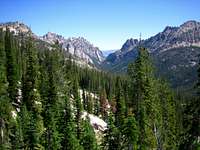
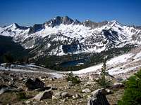
Reaching Elk Peak from the Redfish side involves a scenic trail hike (or run) through the Redfish Creek canyon with it's many technical towers and peaks above. In the upper reaches of Redfish Creek, one must leave the trail and scramble to some scenic and seldom visited alpine lakes at 8600-9000 feet (Lake Kathryn). The sheer towers of the north face of Elk Peak are impressive and daunting from this area. The East Ridge is rugged, sheer, and impressive. The scrambling on Elk peak Ranges from Class 2-4, with the trade off generally being how stable the terrain is. Still, there are various spots where some Class 4 is inevitable, and Class 3 climbing seems to be the bulk of the difficulty while directly on the ridge.
Routes

From the East Ridge, follow the spine west up a steep gully (Class 3-4), or drop to the south of a vertical tower (Class 2-3) and reclimb up an open slope to a point on the ridge just west of this tower. Continue scrambling the ridge (Class 3-4) to reach the East Summit, then descend to the saddle between the East and West Summits. Ascend directly up the West Summit from the saddle over giant loose blocks.
To descend, either retrace or scramble the southeast slopes to the lower valley. It's easy to get cliffed out with the later option, but it can avoid some of the steeper and more loose blocks if done properly.
From the Redfish Inlet Trailhead: 9.1miles and 5165 feet gain (one way with shuttle boat)
From the Redfish Lodge Parking Area: 14.2miles and 5865 feet gain (one way without shuttle boat)
West Ridge (Class 4)- Access this route from Elk Lake on the upper reaches of the South Fork of the Payette River.
From the Grandjean Trailhead: 13.8 miles and 6965 feet gain (one way)
Getting There

From Stanley, Idaho take ID-75 south for 5 miles and turn west (right) onto the Redfish Lake Road. Take this road 2 miles to the backpacker parking lot, or 2.5 miles to the Redfish lake Lodge for day hikers.
Check the road conditions at:Idaho Transportation Department
Hike Approach
Follow the Redfish Creek Trail from the Redfish Inlet if utilizing the shuttle boat. The trail is straight forward and highly scenic. This is probably the most crowded trail in the region.
Redfish Lodge Shuttle Boat

The Redfish Shuttle boat is a great way to shave off 5 miles of the hike that basically just goes around the lake. As nice as this is, there are a few things to note about the Redfish Shuttle Boat.
1. The Shuttle generally runs from 7am to 7pm from June 1st to September 30th, but there can be some variation depending on how busy it's been there.
2. The cost is $7 dollars One Way or $15 Roundtrip. They will only take 2 or more, so if your solo they'll make you wait for someone else which can be a long time.
3. These are seasonal workers from all over running the boats so expect that level of service (Think National Park Service Seasonal Workers). I've experienced boat operators over sleeping, not knowing the geography or climbs of the area, and a general nonchalant attitude. Still, there are a few workers that have been there a while and know the area well and do a good job.
4. If you don't make it back to the dock by 7pm sharp, expect to walk the extra 5 miles. If there's a crowd waiting to go back over at 7pm and they need to make more than one shuttle, you may get lucky a little after 7pm, but don't count on that.
Sawtooth Climbers

Dave Williams- one of the first Sawtooth climbers that lived in the
Stanley area and did informal guiding for the Iowa Mountaineers that frequently
visited the region (1940s). His climbing was probably in the 5.5 range at the
most, but for the day that was considered the hardest. Williams Peak is named
after him.
Bob & Merriam Underhill- were two significant members of the Appalachian Mt. Club (Boston) that Dave Williams guided. Merriam is of particular note because
she was probably the first woman climbing many of the peaks. They climbed and
explored
The Rakers,
Heyburn, and
Horstmann to name a few. Most of the pinnacles and peaks in the Fishhook
Valley are named after Iowa Mountaineers. Mt. Underhill is named after them.
Louis Stur- Hungarian immigrant known for not only doing hard climbs, but
being a really nice person.
The Stur
Chimney on Heyburn is named after him. He concentrated on many of the
impressive towers around Heyburn: Split Tooth, Grand Aguille, Black Aguille. He
died on the north side of
Baron
Peak (His exploration was 1950-60's).
Fred Beckey- hard man climber that made at least 1 whirlwind tour of the
Sawtooths in the 1970's. His marks on the area include the Beckey tree on the
Elephant's Perch and the Beckey Bolt Ladder (A1+) on
Baron
Spire. He definitely pushed the difficulty of the climbing here. At a recent
presentation I asked him about the region and he remembered absolutely nothing!

Lyman Dye- started a guide service in the 70's in the Sawtooths. While he
never climbed real hard (above 5.8), he explored a lot of the Sawtooth peaks,
including many 5th class towers. In a recent sit down with him he expressed that
Packrat Peak was one of his favorite, underrated peaks. He said virtually no
one ever asks him about the Sawtooths anymore and he was delighted to share his
exploring with me.
Kirk Bachman- guided since the 70's in the Sawtooths and also does
backcountry skiing and river running. His Sawtooth Mountain Guides has been
going strong now and offers many great classic rock climbing trips. In a recent
sit down, Kirk knew many of the local names for the unnamed peaks that I've
never heard of and he loved talking about climbs on obscure rock spires in the
area. His ski hut sits at the base of
Williams Peak.
Tom Lopez- the author of Idaho's best, and only mountain guide book
deserves credit for simply collecting an overwhelming amount of climbing info on
so many diverse areas. He overcame the resistance to give up information about
certain areas (a common Idaho rock climbing beta practice) and threats of
violence to establish his book. It's hard to imagine just how difficult it would
be to approach, and even know about, some of the published climbs in his book.
Along the way, he did tons of climbing and a first ascent of Cabin Creek Peak in
the
Salmon River Mountains.

Mark Weber- documented some of his technical climbs in the Sawtooths including The Arrowhead, Eagles Beak, and Mt. Sevy. I applaud his willingness to make public his climbs and even so, these peaks see just a few, if any ascents per year. For example when I summitted The Eagle's Beak in 2006, the last person in the register was from 1991.
Greg Parker- Greg has developed and documented many fine alpine routes in more recent years in the Grandjean / Baron Creek drainage area. His climbs on Warbonnet, Tohobit, Horstmann, and Grandjean are particularly impressive. He's always willing to discuss or help fellow climbers with some of the more obscure routes. Greg's Climbing Site
There are countless others that quietly made impressive ascents and lifetimes worth of achievement without anyone knowing.
Climbing Information

1) Climbing Magazine #15p
2) Rock & Ice #44
3) Off Belay: The Mountain Magazine Feb 1975 #19 (Whole issue devoted to rock climbing in the Sawtooths, but hard to find)
44) American Alpine Journal- Issue 47 (1973)
5) Idaho: A Climbing Guide by Tom Lopez- the best overall collection of information. Covers a large number of peaks, but usually just a paragraph or two per peak, with no climbing topos. A great resource for the area, but some ratings can be off slightly for many different reasons that may or may not have to do with the author.
Conditions and Seasons

Conditions may vary greatly. Access is typically from June to October.
The Redfish Lake area can be the coldest region in the lower 48 during the winter. Summertime can be warm and dry, but the nights are usually cool. Winter comes as early as October, or as late as December. Approach roads usually don't open until May, but you can still ski the approach roads during the winter. Winter ascents are very rare here.
Nearby Stanley, Idaho Climate Data:
| Jan | Feb | Mar | Apr | May | Jun | Jul | Aug | Sep | Oct | Nov | Dec | Annual | |
| Average Max. Temperature (F) | 27.0 | 33.7 | 42.5 | 50.3 | 59.9 | 68.4 | 78.7 | 78.4 | 68.6 | 56.6 | 38.1 | 26.0 | 52.4 |
| Average Min. Temperature (F) | -0.5 | 0.3 | 9.7 | 20.3 | 28.3 | 33.9 | 36.0 | 34.0 | 27.2 | 20.6 | 12.0 | -0.8 | 18.4 |
| Average Total Precipitation (in.) | 1.64 | 1.33 | 1.02 | 1.02 | 1.17 | 1.16 | 0.59 | 0.59 | 0.78 | 0.92 | 1.46 | 1.55 | 13.24 |
| Average Total SnowFall (in.) | 16.9 | 13.2 | 10.2 | 3.4 | 0.9 | 0.2 | 0.0 | 0.0 | 0.4 | 1.7 | 10.4 | 14.6 | 71.9 |
| Average Snow Depth (in.) | 18 | 20 | 15 | 6 | 0 | 0 | 0 | 0 | 0 | 0 | 2 | 8 | 6 |

Links

National Weather Service Current Forecast for Stanley
SNOTEL-gives latest snow depth readings
Sawtooth National Recreation Area