-
 17441 Hits
-
 89.39% Score
-
 29 Votes
|
|
Mountain/Rock |
|---|---|
|
|
44.10347°N / 114.99808°W |
|
|
Boise |
|
|
Hiking, Mountaineering, Trad Climbing, Mixed, Scrambling |
|
|
Summer, Fall |
|
|
10327 ft / 3148 m |
|
|
Overview
Mt. Iowa can be easily climbed with no major difficulties (Class 3) if your very careful with the route finding and choices. Like many of the pinnacles and peaks in the area, the USGS quad doesn't always give an accurate representation. For example, if a gendarme of vertical rock sits on a ridgeline, but doesn't extend over 40 feet vertically (the USGS contour) it may not even be shown in any respect on the map. In other cases there's just erroneous surveying and mapping. Many of the USGS quads date back to the 1970s or before.
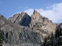
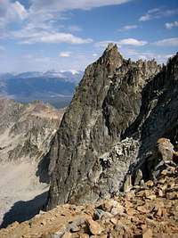
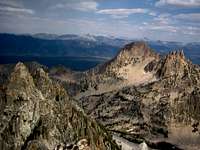
Mt. Iowa contains 3 major summits with the west summit being the tallest. The East summit is somewhat visible from the Fishhook / Stanley area and contains a vertical rock wall of 800 feet guarding it's northeast side. The slopes south and east of the peak are steep, loose, and rugged. The west and northwest approach to the summit contain the only known non-technical routes.
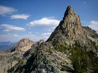
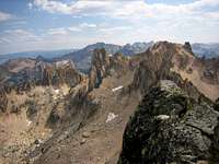
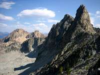
One of the true delights of summiting Mt. Iowa is being so close to FishHook Spire, one of the true hidden rock climbing gems in the area. Also strikingly visible from the summit is Mt. Heyburn, Horstmann Peak, Ed-A-Ho Spire, Rothhorn Spire, Stephens Spire, Mt Ebert, Rotten Monolith, Peak 9561, and Braxon Peak.
Routes
From the Redfish Backpacking Trailhead: 7.0miles and 4310 feet gain (one way)
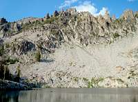
West Face via Stephens Lake (Class 3)- from the FishHook Creek valley, take the trail until it peters out (about 3 miles from the Trailhead). Follow the valley north of Horstmann to the uppermost of Stephens Lakes. The hiking off trail can be tiresome through the lower forest as you cross logs and creeks constantly. The Stephens Lakes basin is spectacular, pristine, and seldom visited. Climb north toward the base of Fishhook Spire, then switchback to the southeast and get to the FishHook Iowa saddle. Scramble onto the west face of Iowa over large blocks and then onto solid rock to the summit.
From the Redfish Backpacking Trailhead: 8.8miles and 4094 feet gain (one way)
Northwest Ridge (Class 4)- for a little added exposure and challenge, ascend the obvious short ridge from the FishHook Iowa saddle. The rock is mostly solid.
Getting There
From Stanley, Idaho take ID-75 south for 5 miles and turn west (right) onto the Redfish Lake Road. Take this road 2 miles to the backpacker parking lot.
Check the road conditions at: Idaho Transportation Department
Hike Approach
Start at the backpackers parking lot and take the mostly flat and well traveled trail past the Marshall Lake turnoff sign to a beautiful meadow with great views of Horstmann Peak, Mt. Bush and Thompson's rugged east ridge. Continue on until the trail crosses a creek and peters out.
History

The summit log contained some interesting names. It was an honor to see Paul Petzoldt's historic signature. Below is a brief history of some of the
names found in the register.
Paul Petzoldt- A true mountaineering pioneer. Paul grew up in southern Idaho and frequently climbed in the Sawtooths, Wind River Range and Tetons where he ascended the Grand Teton in cowboy boots and made the first winter ascent ever. He formed one of the first guide groups for the Tetons, climbed on the first American expedition on K2, formed the first outward bound program in Colorado, and founded NOLS in Wyoming. While pioneering in the Tetons, Petzoldt was credited with 26 first ascents. The Petzoldt Ridge on the Grand Teton and the Petzoldt Couloir on Mt. Heyburn were named in his honor.
He led Bob& Merriam Underhill, Bruce Adams, John Speck, Cole Fischer, and Cal Wilcox to the first ascent of Mt. Iowa in 1947.
Bob & Merriam Underhill- were two significant members of the Iowa
Mountaineers that Dave Williams and Paul Petzoldt guided. Merriam is of particular note because
she was probably the first woman climbing many of the peaks. They climbed and
explored
The Rakers,
Heyburn, and
Horstmann to name a few. Most of the pinnacles and peaks in the Fishhook
Valley are named after Iowa Mountaineers. Mt. Underhill is named after them and
Mt. Iowa is named after their organization after they made the first ascent with
Paul Petzoldt.
Lyman Dye- started a guide service in the 70's in the Sawtooths.
Pioneered and explored a lot of the Sawtooth peaks,
including many 5th class towers. In a recent sit down with him he expressed that
Packrat Peak was one of his favorite, underrated peaks. He said virtually no
one ever asks him about the Sawtooths anymore and he was delighted to share his
exploring with me.
Tom Lopez- the author of Idaho's best, and only mountain guide book
deserves credit for simply collecting an overwhelming amount of climbing info on
so many diverse areas. He overcame the resistance to give up information about
certain areas (a common Idaho rock climbing beta practice) and threats of
violence to establish his book. It's hard to imagine just how difficult it would
be to approach, and even know about, some of the published climbs in his book.
Along the way, he did tons of climbing and a first ascent of Cabin Creek Peak in
the
Salmon River Mountains.
Sources

1) Climbing Magazine #15/p>
2) Rock & Ice #44
3) Off Belay: The Mountain Magazine Feb 1975 #19 (Whole issue devoted to rock climbing in the Sawtooths, but hard to find)
4) American Alpine Journal- Issue 47 (1973)
5) Idaho: A Climbing Guide by Tom Lopez- the best overall collection of information. Covers a large number of peaks, but usually just a paragraph or two per peak, with no climbing topos. A great resource for the area, but some ratings can be off slightly for many different reasons that may or may not have to do with the author.
Personal Interviews, conversations, and emails with Lyman Dye, Fred Beckey, and Kirk Bachman
Conditions and Season
Conditions may vary greatly. Access is typically from June to October.
The Redfish Lake area can be the coldest region in the lower 48 during the winter. Summertime can be warm and dry, but the nights are usually cool. Winter comes as early as October, or as late as December. Approach roads usually don't open until May, but you can still ski the approach roads during the winter. Winter ascents are very rare here.
Nearby Stanley, Idaho Climate Data:
| Jan | Feb | Mar | Apr | May | Jun | Jul | Aug | Sep | Oct | Nov | Dec | Annual | |
| Average Max. Temperature (F) | 27.0 | 33.7 | 42.5 | 50.3 | 59.9 | 68.4 | 78.7 | 78.4 | 68.6 | 56.6 | 38.1 | 26.0 | 52.4 |
| Average Min. Temperature (F) | -0.5 | 0.3 | 9.7 | 20.3 | 28.3 | 33.9 | 36.0 | 34.0 | 27.2 | 20.6 | 12.0 | -0.8 | 18.4 |
| Average Total Precipitation (in.) | 1.64 | 1.33 | 1.02 | 1.02 | 1.17 | 1.16 | 0.59 | 0.59 | 0.78 | 0.92 | 1.46 | 1.55 | 13.24 |
| Average Total SnowFall (in.) | 16.9 | 13.2 | 10.2 | 3.4 | 0.9 | 0.2 | 0.0 | 0.0 | 0.4 | 1.7 | 10.4 | 14.6 | 71.9 |
| Average Snow Depth (in.) | 18 | 20 | 15 | 6 | 0 | 0 | 0 | 0 | 0 | 0 | 2 | 8 | 6 |

Links

National Weather Service Current Forecast for Stanley
SNOTEL-gives latest snow depth readings
Sawtooth National Recreation Area