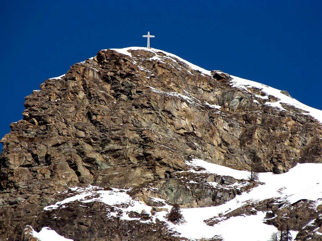
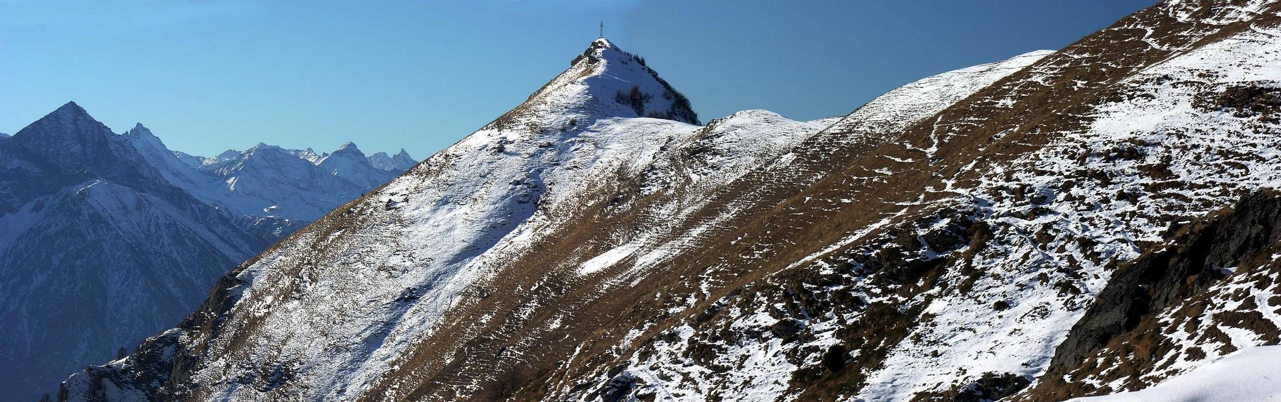
The long crest that separates the Valtournenche (to East) from the Valley of Saint Barthélemy (to West) he takes origin from the Mont Redessau (3.253m) and it goes down with direction comprehensive South, in succession, of the Pecks at des Crottes, Cime Bianche, Mont Miracle, Mont Meabé, Mont de the Fenetre Becca at to have; from this point the same one is undoubled, sending a secondary branch toward If and Pass of Borne (or Pass the Bornes; 1.744m) and another to Southwest. This last, after having formed the Summit of Longhede, it lowers to the Filon Pass, it raises again him to the Mont Ander for then "to die" on the wooded summit of the Mont de Pesse (1.708m); this line of crest overhangs the Commune of Verrayes and its beautiful basin. It easily shears attainable is from South with departure from Grand-Villa old Village (1.412/1.437m) that from S-E for the road to the Little Champlong in the proximities of the minuscule Lake Loson, as well as the following municipal road in asphalt surface that climbs to Clavon Village (1.644m) and to the overhanging Area Pic Nic of Champlong (poster of prohibition to quota 1.918m, under the Pass de Bornes. Attainable also in the Valley of Saint Barthélemy, departing from the place Les Fontanes (1.664m) along a path that it goes up again the Northern Slope of it reaching the saddle among this and the Becca of Aver. Or through goes up again it some West side of the Fenetre Pass and crossing climbing over the homonym Mont, the Top of Aver to the Summit of Longhede. Otherwise from the Valtournenche in the Commune of Torgnon by this same route starting from Chantorné Pastures, or through the earth road "poderale" for the Col des Bornes or and still through the carriage one from Torgnon Commune for the Saint Pantaléon Pass connecting himself with a beautiful muletrack toward the Bornes Pasture, under the homonym hill. On the peak it is situated a gigantic metallic cross, that the big jump dominates rocky verse Southwest, under to which exist some caves of green marble (serpentine); toward South-southeast steep groins grassy rocky dizzy with great boulders go down in direction of the Village of Grand-Villa, but I are him to surely consider unadvisable for an ascension for the due dangerousness to the presence of grass "ollina." Also the northern slope, formed by rocky bands mixed to trees it doesn't surely attract for a slope.
IMPORTANT REMARK: it is worthwhile to climb through the path that conducts to instead Becca of Aver (= Summit of Aver; 2.469m) and from this to continue with easy crossing in crest toward Southwest, reaching the top of it through the easy NE Crest. Originating instead from the Communes of Saint Barthélemy or Torgnon is advisable the beautiful crossing on the crest watershed that begins from the Fenetre Pass. Advisable trip also in beginning of season, or to the arrival of the first winter snow through the snow rackets. Beautiful views toward the nearby Group of Mount Faroma, Becca of Luseney and her district toward North and on the triptych Mount Emilius-Tersiva Point-Mount Avic toward South.
La lunga cresta che separa la Valtournenche (ad E) dalla Valle di Saint Barthélemy (ad O) prende origine dal Mont Redessau (3.253 m) e scende con direzione S comprensiva, in successione, della Becca des Crottes, Cime Bianche, Monte Miracolo, Mont Meabé, Mont de la Fenetre Becca d'Aver; da questo punto la stessa si sdoppia, inviando un ramo secondario verso SE ed il Col des Bornes ed un altro a SO. Questo ultimo, dopo aver formato la Cima di Longhede, si abbassa al Col de Filon, si rialza al Mont Ander per poi "morire" sulla sommità boschiva del Mont de Pesse (1.708 m); questo tratto di cresta sovrasta il Comune di Verrayes e la sua bella conca. Cima facilmente raggiungibile sia da S con partenza da Grand-Villa (1.412/1.437 m) che da S-SE per la strada adducente al Petit Champlong nelle vicinanze del minuscolo Lago Loson, nonché la successiva strada comunale in asfalto che sale a Clavon (1.644 m) ed alla soprastante Area Pic Nic di Champlong (cartello di divieto a quota 1.918 m), sotto il Col de Borne (oppure Col le Bornes; 1.744 m). Raggiungibile anche dalla Valle di Saint Barthélemy, partendo dalla località Les Fontanes (1.664 m) lungo un sentiero che ne risale il lato Settentrionale arrivando alla sella tra questa e la Becca d'Aver; o tramite la risalita del lato Ovest del Col Fenetre e traversata scavalcando l'omonimo Mont, la Becca d'Aver fino alla Cima di Longhede. Altrimenti dalla Valtournenche nel Comune di Torgnon con questa stessa via, partendo dal Chantorné, oppure tramite la strada poderale per il Col des Bornes, ovvero ed ancora tramite la carrozzabile da Torgnon per il Col Saint Pantaléon ricollegandosi con una bella mulattiera verso l'Alpe Bornes, sotto l'omonimo colle. Sulla vetta è collocata una gigantesca croce metallica, che domina il gran salto roccioso verso SO, sotto al quale esistono delle cave di marmo verde (serpentino); verso S-SE ripidi costoloni erboso rocciosi con grandi massi scendono vertiginosamente in direzione del Villaggio di Gran-Villa, ma sono da considerarsi sicuramente sconsigliabili per un'ascensione causa la pericolosità dovuta alla presenza di erba "ollina". Anche il versante settentrionale, formato da fasce rocciose frammiste ad alberi non attrae sicuramente per una salita.
ANNOTAZIONE IMPORTANTE: conviene invece salire , partendo dai Comuni di Verrayes/Saint-Denis, per mezzo del sentiero conducente alla Becca d'Aver (2.469 m) e da questa proseguire con facile traversata in cresta verso SO, raggiungendone la cima lungo l'elementare Cresta NE. Provenendo invece dai Comuni di Saint Barthélemy o Torgnon é consigliabile la bella traversata sulla cresta spartiacque che inizia dal Col Fenetre. Gita consigliabile anche in inizio di stagione, oppure all'arrivo della prima neve invernale per mezzo delle racchette da neve. Belle vedute verso il vicino Gruppo del Monte Faroma, la Becca di Luseney ed il suo circondario verso N e sul trittico Monte Emilius-Punta Tersiva-Monte Avic verso meridione.
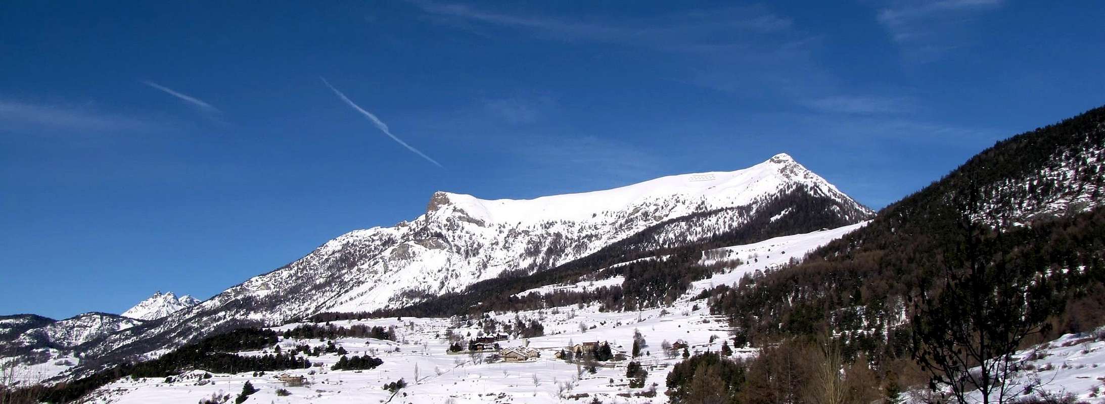
Starting from Torgnon's Commune and surroundings.
Partendo dal Comune di Torgnon e dintorni.
HISTORICAL NOTES & of CHRONICLE
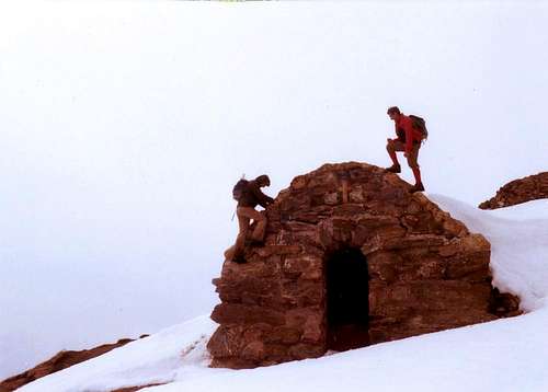
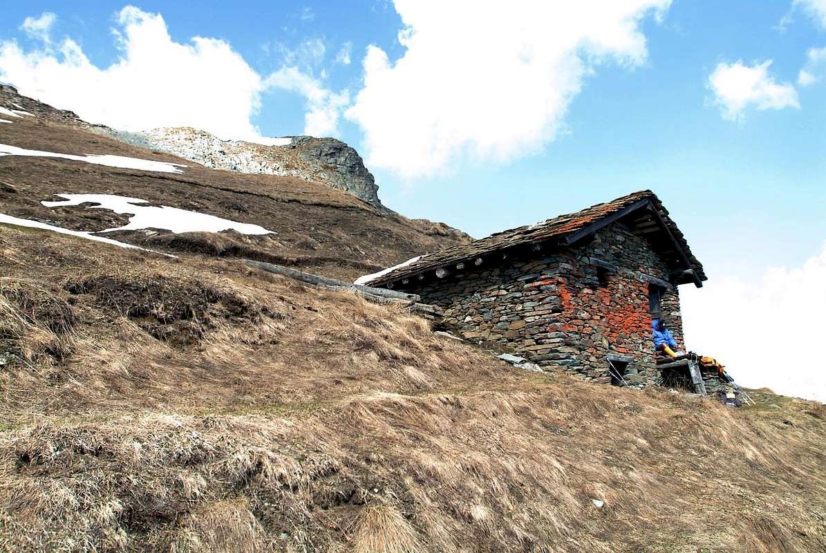
Reached top and frequented "ab immemorabilis", as it also testifies the great construction in stone and wood of the very ancient pasture, by now almost entirely in downfall, as soon as below the crest watershed among Top of Longhede and the Summit of Aver (more nearby to this last); the whole southern slope of the two tops was in the remote times used for the "pastorizia" (= sheep farming) despite the steep displayed inclinations along the slopes. Surely also frequented by the hunters (I am also easily sighted the fallow deer and the chamois to low quotas, as in the underlying wood the Village of Roves) of the five Communes to his base (Nus, Verrayes, Saint-Denis, Torgnon and Saint Barthélemy). Surely, exploiting favourable years, with scarce covered with snow to the beginning or at the end of the season, the top had also been climbed winter, even if don't have certain news. The first alpine annotations we find her in the Bulletin of the C.A.I. XXVIII° "The Valley of St- Barthélemy", pages 11-94, to work of the mountain climbers Ettore Canzio and Felice Mondini. The same called however her with an improper toponym or placename, defining generically the "Becca"(= Top with a protruding "chin") also the Summit of Aver (more in detail in pages 49-50), while this peak be himself in more reality to Northeast, along the same coastline, and anciently as Mountain it was also known her Borne (you see same monograph of the Bulletin XXVIII°, page 49, and Paper of the 1899 bottom quoted). Error extended him for long period, also from the local inhabitants, that only in the last decades he has been unraveled and disentangled with a precise I distinguish among the two Peaks. The study was accompanied by a Paper to the 50.000 of the I.G.M. (= Institute Geographical Military Italian) of the year 1899. Also in her "Guide of the Alps Westerners Vol.II. Graian and Pennine Second Part Her Valleys of Aosta, of Biella, of the Sesia and of the Ossola", the famous one "BandV", to work by Luigi Bobba and Giovanni Vaccarone and Editted by the Section in Turin of the Italian Club Alpine May 25,th 1896, indication it is not found any to the top in matter and the only attentions and considerations they are those concerned, to page 336, the nearby Becca of Aver. Still in the Bulletin the relationship of a slope is found in August of 1894 to work of the Lawyer Darbellay, President of the Section of the C.A.I. of Aosta and relative party with departure enough "exotic" from the Alpe of Pierrey (1.910m), near that of Champ Plaisant (1.906m; + Sanctuary) in the Valley of Saint Barthélemy. In every case it deals with the first alpine information and not surely of the first absolute ascension, for the motives above quoted. The same is used in the year 1970 from the Guide of the Mountains of Italy C.A.I./T.C.I. "Alps Pennine II", pages 493-4,ad work by Gino Buscaini as described route relative the Northern Slope. Together with the itinerary 218e), regarding the slope common to he Pecks at it to have (pages 492-3), with departure near Issologne Village and however always in the Valley of Saint Barthélemy toward the large saddle between the two peaks, they are the alone annotations of slope to the mountain into the same mountain guide book. In the winter season instead it results worthy of note (to see First Ascents) the attempt effected by three mountain climbers of Aosta Town to cross, through snowshoes, the whole Crest Southwest watershed between Nus (in West) and Verrayes (in East) Communes, with departure from the Village of Praille (1.242m), into the of Nus Commune. The same stranded on the great Shoulder West of the Top of Longhede because of the very tall and dangerous snow, as well as of the sighting of the continuous bustle from helicopters from the Airport of Aosta toward the Mount Fallère (3.061m), such to make to intend nothing of good person and what something of very serious had happened (avalanche with ten buried and four corpses, Jan 12th, 2003).
Crux for almost all the departures through the path n° 1.
Nodo cruciale per quasi tutte le partenze tramite il sentiero n° 1.
NOTE STORICHE e "CRONICON"
Cima raggiunta e frequentata "ab immemorabilis", come testimonia anche la grande costruzione in pietra e legno dell'antichissimo alpeggio, ormai quasi del tutto in rovina, appena al di sotto della cresta spartiacque tra la Cima di Longhede e la Becca d'Aver (più prossima a quest'ultima); tutto il versante meridionale delle due cime era nei tempi remoti utilizzato per la pastorizia, nonostante le ripide pendenze ostentate lungo i pendii. Sicuramente frequentata anche dai cacciatori (sono facilmente avvistabili il daino ed il camoscio anche a basse quote, come nel bosco sottostante il Villaggio di Roves) dei cinque Comuni alla sua Base (Nus, Verrayes, Saint-Denis, Torgnon e Saint Barthélemy. Sicuramente, sfruttando annate favorevoli, con scarso innevamento all'inizio od alla fine della stagione, la cima fu salita anche di inverno, anche se non se ne posseggono notizie certe. Le prime annotazioni alpinistiche le troviamo nel Bollettino del C.A.I. XXVIII° "La Valle di St-Barthélemy", pagine 11-94, ad opera degli alpinisti Ettore Canzio e Felice Mondini. Gli stessi la denominavano però con un toponimo improprio, definendola genericamente Becca o Cima d'Aver (più specificatamente pagine 49-50), mentre questa vetta trovasi in realtà più a Nordest, lungo la stessa costiera, ed anticamente era anche conosciuta come Monte La Borne (vedi medesima monografia del Bollettino XXVIII°, pagina 49, e Carta del 1899 sotto citata). Errore protrattosi per lungo periodo, anche da parte degli abitanti locali, che solo negli ultimi decenni é stato dipanato e chiarito con un preciso distinguo tra le due Vette. Lo studio era accompagnato da una Carta al 50.000 dell'I.G.M. (= Istituto Geografico Militare Italiano) dell'anno 1899. Anche nella "Guida delle Alpi Occidentali Vol.II. Graie e Pennine Parte Seconda Le Valli di Aosta, di Biella, della Sesia e dell'Ossola", ad opera di Luigi Bobba e Giovanni Vaccarone ed Editata dalla Sezione di Torino del Club Alpino Italiano il 25 Maggio 1896, non si trova accenno alcuno alla cima in questione e le uniche attenzioni e considerazioni sono quelle concernenti, a pagina 336, la vicina Becca d'Aver. Ancora nel Bollettino si trova la relazione di una salita nell'Agosto del 1894 ad opera dell'Avvocato Darbellay, Presidente della Sezione del C.A.I. di Aosta, e relativa comitiva con partenza abbastanza "esotica" dall'Alpe di Pierrey (1.910 m), presso quella di Champ Plaisant (1.906 m; + Santuario) in Valle di Saint Barthélemy. In ogni caso si tratta della prima informazione alpinistica e non sicuramente della prima ascensione assoluta, per i motivi sopra citati. La stessa viene utilizzata nell'anno 1970 dalla Guida dei Monti d'Italia C.A.I./T.C.I. "Alpi Pennine II", pagine 493-4, ad opera di Gino Buscaini, come via descritta concernente il Versante Settentrionale. Insieme all'itinerario 218e), riguardante la salita comune alla Becca d'Aver (pagine 492-3), con partenza nei pressi di Issologne e comunque sempre in Valle di Saint Barthélemy in direzione dell'ampia sella tra le due cime, sono le sole annotazioni di salita alla montagna nella guida medesima. Nella stagione invernale invece risulta degno di nota (vedere First Ascents) il tentativo effettuato da tre alpinisti aostani di percorrere, per mezzo di racchette da neve, l'intera Cresta SO spartiacque tra i Comuni di Nus (ad Ovest) e Verrayes (ad Est), con partenza dal Villaggio di Praille (1.242 m), nel Comune di Nus. Lo stesso si arenò sul grande Spallone Ovest della Cima di Longhede a causa della neve molto alta e pericolosa, nonchè dell'avvistamento del continuo andirivieni da parte di elicotteri dall'Areoporto di Aosta verso il Mont Fallère (3.061 m), tale da far intendere nulla di buono e che qualcosa di molto grave fosse successo (valanga con dieci sepolti e quattro morti, il 12 Gennaio 2003).
First Ascents
First? on the summit (by N Slope): Darbelley and Company of Aosta C.A.I., in August 1894.
In winter: Unknown.
Winter try through the entire SW watershed Pesse Pass and Mount-Joux Pass-Mont Ander-Filon Pass) up to the West Shoulder: Osvaldo Cardellina, Emilio Bertona and Gianfranco Vicentini, Jan 12th, 2003, by snowshoes in ascent and descent from Praille Village.
NE Crest (Standard Route): Unknown.
S-SE Slope: Osvaldo Cardellina, Marco Cossard and Giuseppe Lamazzi, Apr 08th, 1973.
Getting There
BY CAR:
From Torino City, Milano City, etc: Motorway A5. Exit at Chatillon or Nus.
From Switzerland: through the Grand Saint Bernard Tunnel or the namesake pass.
From France: through Mont Blanc Tunnel or Petit Saint Bernard Pass. It isn't necessary to take Motorway A5: you can drive on SS.26, in the direction of Aosta.
BY PLANE:
Aeroporto "Corrado Gex" Saint Christophe (Aosta).
Approachs
Anticlockwise from the Basin of Verrayes (A)/Saint-Denis (B) Municipality, from Valtournenche and Antey-Saint André/Torgnon (C, D and E) Municipality, from Nus Municipality in Saint Barthélemy Valley (F), from High and Upper Hill of Nus Commune (G) and of roads various connections.
From Aosta Town to address him to is long the SS.26, after the little Municipalityes of Quart and Nus and the Fraction of Champagne, reaching the Municipality of Chambave, from where two possibilities of it jumps lugo the town roads for Verrayes or for Saint-Denis and one of connection among the two Municipalityes ; or from Chambave little Town to continue for the Town of Chatillon (otherwiseand by the A5 Exit Out near Chatillon) from this to actually go up again the Lower Valtounenche to Antey-Saint Andrè and to divert toward the Municipality of Torgnon, from where with the Regional road to the Saint Pantaléon Pass.
Da Aosta indirizzarsi ad E lungo la SS.26, dopo i piccoli Comuni di Quart e Nus e la Frazione di Champagne, raggiungendo il Comune di Chambave, donde due possibilità di risalita lugo le strade comunali per Verrayes o per Saint-Denis ed una di collegamento tra i due comuni; oppure dal piccolo centro di Chambave continuare per la Cittadina di Chatillon (altrimenti tramite la A5, uscita di Chatillon) e da questa risalire la Bassa Valtounenche sino ad Antey-Saint Andrè e deviare verso il Comune di Torgnon, donde con la strada Regionale al Col Saint Pantaléon.
A) - (along the Municipality of Verrayes): from these on town carriage road immediately to turn on the left (poster for Verrayes) and to reach in 10 Kms the Commune of Verrayes (991m; beautiful deserving center of a visit, above all in his ancient church and positioned above a laughing promontory), after having overcome the Fraction Perret and, with two hairpin bends, the Village of Marseiller (801m). From this last with other about ten winding road to reach it. From Verrayes, turning behind the beautiful church (+; fountain and monument to the Fallen ones of the two World Wars on the plaza), to continue toward East through the homonym Plan passing some fractions (1.016m-1.038m) and reaching those of Gros (1.046m) and Petit Ollian (1.052m). Here the carriage one reverses completely direction toward Northwest before, reaching in succession the Villages of Pissina, Tessella or Tessellaz (1.138m), Chesseille or Chez-Cellier (1.129m; * possible brief excursion through the path n° 1 all'"Arboretum"; +) and Promélian (1.171m) and toward East later addressing itself to an intersection to quota 1.220m~. From the alternative to continue toward West-northwest and, passing for the Fractions of Marquis (1.288m; earth road "poderale" toward North directed for Goilles 1.421m and Los(z)on 1.520/5m) and Dorinaz (1.323m), to pass with an angle acute hairpin bend the bridge on the Torrent de Crétaz reaching the following one of Charr(i)ère. Immediately after another similar winding road, near the alternative 1.344m reverses the direction of North march Southwest addressing itself toward the important and ancient center lived of Grand-villa (1.407/37m), to the feet of the Top of Longhede with the impending his caves of marble. From the village the carriage one, aiming toward East-northeast and left to the right immediately the alternative for Goilles, salt with wide winding road and, abandoning to the left then the following alternative for the Alp Fountain, it reaches around an important intersection to quota 1.590/1.600m with the road that originates from the Municipality of Saint-Denis and that it stops by the Losons. Left in low the ramification for this last place and immediately to the right that for the small Village of Clavon (1.644m), shortly the road reaches the area Picnic of Champlong near a wooded promontory with awry in a small grassy open space its lower case lake and relative parking lot parking lot.
A) - (lungo il Comune di Verrayes): da questi su strada carrozzabile comunale svoltare subito sulla sinistra (cartello per Verrayes) e raggiungere in 10 Km il Comune di Verrayes (991 m; bel centro meritevole di una visita, soprattutto per la sua antica chiesa e posizionato sopra un ridente promontorio), dopo aver superato la Frazione Perret e, con due tornanti, il Villaggio di Marseiller (801 m). Da quest'ultimo con un'altra decina di tornanti raggiungerlo. Da Verrayes, girando dietro la bella chiesa (+; fontanile e monumento ai Caduti delle due Guerre Mondiali sulla piazza), proseguire verso oriente attraverso l'omonimo Plan passando alcune frazioni (1.016 m-1.038 m) e raggiungendo quelle di Gros (1.046 m) e Petit Ollian (1.052 m). Qui la carrozzabile inverte completamente direzione verso Nordovest prima, raggiungendo in successione i Villaggi di Pissina, Tessella o Tessellaz (1.138 m), Chesseille o Chez-Cellier (1.129 m; * possibile breve escursione tramite il sentiero n° 1 all'"Arboretum"; +) e Promélian (1.171 m) e verso Est dopo indirizzandosi ad un incrocio a quota 1.220 metri circa. Dal bivio proseguire verso Ovest-nordovest e, passando per le Frazioni di Marquis (1.288 m; strada poderale verso Nord diretta per Goilles 1.421 m e Los(z)on 1.520/5 m) e Dorinaz (1.323 m), passare con un tornante ad angolo acuto il ponte sul Torrent de Crétaz raggiungendo la successiva di Charr(i)ère. Subito dopo un altro similare tornante, presso il bivio 1.344 m, inverte la direzione di marcia da Sudovest a Nord indirizzandosi verso l'importante ed antico centro abitato di Grand-Villa (1.407/37 m), ai piedi della Cima di Longhede con le sue sovrastanti cave di marmo. Dal villaggio la carrozzabile, puntando verso Est-nordest e lasciato subito a destra il bivio per Goilles, sale con larghi tornanti ed, abbandonando poi a sinistra il successivo bivio per l'Alpe Fontane, raggiunge un incrocio importante a quota 1.590/1.600 m circa con la strada che proviene dal Comune di Saint-Denis e che passa dai Loson. Lasciata in basso la diramazione per questa ultime località e subito a destra quella per il piccolo Villaggio di Clavon (1.644 m), la strada in breve raggiunge l'Area Pic Nic di Champlong presso un promontorio boschivo con a monte in una piccola spianata erbosa il suo minuscolo lago e relativo parcheggio parcheggio.
B) - (along the Commune of Saint-Denis): to reach the intersection of the road instead that, always departing more aloft from Chambave with system of signs in comparison to the preceding road and that it goes up again the more hill toward Northeast, it passes for the Commune of Saint-Denis (781m). From this the carriage one, after brief line it reaches the Fraction of Plantery for then to climb toward north with enough narrow tornanti and to reach the following ones of Etrobleyaz, Petit and Grand Bruson (near the Village of Moral; 1.138m); from the biovio Moral/Grand Bruson the road various Northeast direction in Northwest and, after having overcome a secondary brook as well as the most important Torrent de Chambave, reaches in succession the notable Fractions of the (1.260m * * CONNECTION with road asphalted with the preceding one by risalente from Verrayes with union to the preceding alternative the Village of Marquis ), Plau (1.305m) and Semon (1.400m~). with wide turn seeds circular Est/Ovest the same goes up again addressing himself near the Village of Cheresoulaz (1.490m) and the following * * * Saint Pantaleon Pass (1.650m; it is also possible to depart from this point through a beautiful muletrack, that begins about fifty meters to North addressing herself with n° 4 it initials her 4 toward the Alp and Pass of Bornes). To abandon the main road for the pass and to divert to the left instead (West) along a rectilinear line, that passes in front of the rests and to the ruins of the two Alps Roves (1.495m~; fountain with drinkable water on the eyelash of the road); to flank the ex Lake Loz(s)on, by now covered by reeds, reaching the homonym Village (1.520/25m) and the following one of Petit Lozon (1.545/50m); with two wide windings road, leaving on the right the small Village of Malavieille, to reach the intersection coming from Grand-Villa 1.590/1.600m~ and the deviation for the Sermont Pasture (1.553m). Discarding East again the following Village of Clavon (1.644m), with the road of the preceding approach, to reach the area Picnic of Champlong with his attractive little pond, near the log cabin "Les Amis de Verrayes" (= "of Verrayes Friends").
B) - (lungo il Comune di Saint-Denis): raggiungere invece l'intersecazione della strada che, sempre partendo da Chambave con segnaletica più in alto rispetto alla strada precedente e che risale la collina più verso Nordest, passa per il Comune di Saint-Denis (781 m). Da questo la carrozzabile, dopo breve tratto raggiunge la Frazione di Plantery per poi salire verso settentrione con abbastanza stretti tornanti e raggiungere le successive di Etrobleyaz, Petit e Grand Bruson (presso il Villaggio di Moral; 1.138 m); dal bivio Moral/Grand Bruson la strada varia direzione da Nordest in Nordovest e, dopo aver superato un rivo secondario nonché il più importante Torrent de Chambave, raggiunge in successione le notevoli Frazioni di Del (1.260 m; * * COLLEGAMENTO con strada asfaltata con la precedente via risalente da Verrayes con congiungimento al bivio precedente il Villaggio di Marquis), Plau (1.305 m) e Semon (1.400 m~) con largo giro semi circolare Est/Ovest la stessa risale indirizzandosi presso il Villaggio di Cheresoulaz (1.490 m) ed il successivo * * * Colle di Saint Pantaleon (1.650 m; è possibile anche partire da questo punto tramite una bella mulattiera, che inizia una cinquantina di metri a N indirizzandosi con la sigla n° 4 verso l'Alpe ed Il Col de Bornes). Abbandonare la strada prinicipale per il colle e deviare invece a sinistra (Ovest) lungo un tratto rettilineo, che passa davanti ai resti ed alle rovine delle due Alpi Roves (1.495 metri circa; fontana con acqua potabile sul ciglio della strada); fiancheggiare l'ex Lago Loz(s)on, ormai ricoperto da canneti, raggiungendo l'omonimo Villaggio (1.520/25 m) ed il successivo di Petit Lozon (1.545/50 m); con due larghi tornanti, lasciando sulla destra il piccolo Villaggio di Malavieille, raggiungere l'incrocio proveniente da Grand-Villa 1.590/1.600 metri circa e la deviazione per l'Alpe Sermont (1.553 m). Scartando acora ad Est il successivo Villaggio di Clavon (1.644 m), con la strada dell'avvicinamento precedente, raggiungere l'Area Pic Nic di Champlong con il suo grazioso laghetto, presso la baita "Les Amis de Verrayes".
C) - (along the Valtournenche through the Communes of Antey-Saint André and Torgnon to and by the Saint Pantaléon Pass): from the little Chatillon Town, reached through the SS.26, and from this "to take" to a rotunda, with statue-stonecarving of the Matterhorn, the carriage one toward the Valtournenche. To go up again it toward North along the bank western hydrographical of the Torrent Marmore and, transiting from the Villages of Saix de Vau (630m), Champlong (712m), Covalou with his Plant Hydro Electric, immediately after this, to go himself on the oriental bank through the bridge to quota 795m, as soon as over the two fractions of Lilac and Chessin. The rectilinear continuous road up to the Center Tourist of Antey-Saint André (947m; 1.015m the Bourg), from which he passes through again on the opposite bank a beautiful bridge, between the Fractions of Filey and Grand Moulin, to be able to reach the Commune of Torgnon. You transits for the important Villages of Nozon, Chésod, Champagnod, Mazod, Verney to reach the center of the country. Leaving the continuation of the road to north toward Septumian, Pecou, Chaté and Cheille, he turns to the left (Southwest) taking that for the With the de Saint Pantaléon (1.650m); with three windings road he reaches the Fraction of Ronc Dessus, from which he continues through the forest of pines with alternate more rectilinear run to wide hairpin bends. Finally supporting first southeast and then, in the last line, to South the same one is reached, sets above a small Chapel, devoted Saint to the homonym; as soon as before the pass it unties him to west (signals) the beautiful muletrack/path n°4 for the Pass of the Bornes, that allows to be connected with himself to the routes coming from Verrayes and Saint-Denis. * * * * Valtournenche/Saint-Denis-Verrayes Basin ROADS CONNECTION: otherwise, going down from the Saint Pantaléon Pass with some windings road for the carriage one toward Southwest, it reunites us to the preceding approaches, near the alternative between the two Fractions of Roves and Cheresoulaz (1.490m~).
C) - (lungo la Valtournenche lungo i Comuni di Antey-Saint André e Torgnon e per mezzo del Col Saint Pantaléon): dalla piccola Città di Chatillon "imboccare" ad una rotonda, con statua-scultura del Cervino, la carrozzabile verso la Valtournenche. Risalirla verso Nord lungo la sponda idrografica occidentale del Torrente Marmore e, transitando dai Villaggi di Saix de Vau (630 m), Champlong (712 m), Covalou con la sua Centrale Idro Elettrica, subito dopo questa, portarsi sulla sponda orientale tramite il ponte a quota 795 m, appena oltre le due frazioni di Lilla e Chessin. La strada continua rettilinea fino al Centro Turistico di Antey-Saint André (947 m; 1.015 m il Bourg), dal quale si passa nuovamente sulla sponda opposta per mezzo di un bel ponte, tra le Frazioni di Filey e Grand Moulin, per poter raggiungere il Comune di Torgnon. Si transita per gli importanti Villaggi di Nozon, Chésod, Champagnod, Mazod, Verney per raggiungere il centro del paese. Lasciando a settentrione la continuazione della strada verso Septumian, Pecou, Chaté e Cheille, si svolta a sinistra (Sudovest) prendendo quella per il Col de Saint Pantaléon (1.650 m); con tre tornanti si arriva alla Frazione di Ronc Dessus, dalla quale si prosegue attraverso la foresta di pini con percorso più rettilineo alternato a larghi tornanti. Appoggiando infine prima a Sudest e poi, nell'ultimo tratto, a Sud si raggiunge il medesimo, posto sopra una piccola Cappella dedicata all'omonimo Santo; appena prima del valico si snoda ad occidente (segnalazioni) la bella mulattiera/sentiero n°4 per il Col des Bornes, che permette di riallacciarsi alle vie provenienti da Verrayes e Saint-Denis. * * * * COLLEGAMENTO STRADALE Valtournenche/Conca di Saint-Denis-Verrayes: altrimenti, scendendo dal Col Saint Pantaléon con alcuni tornanti per la carrozzabile verso Sudovest, ci si riunisce agli avvicinamenti precedenti, presso il bivio tra le due Frazioni di Roves e Cheresoulaz (1.490 m~).
D) - (from the center of Torgnon through the Town Road for Plan Proz Rion or Prorion)): through the previous Approach C)- to reach the Commune of Torgnon; from the its principal square to continue toward Northwest, immediately leaving on the right the alternative 1.544m for Cheille (1.510m) as well as a second to quota 1.567m, and, through an angle straight winding road, to reach the Fraction of Chatrian (1.608m), from which, through another to acute angle, it brings him to the "Agriturismo (= Farm Holidays) Les 4 Saisons", near the Fraction of Pecou (1.662m); from the restaurant, leaving the deviation to North for Chaté (1.697m), he continues, passing under the Chair lift of Chantorné, toward Southwest reaching the great Village of Septumian (1.678m; Church and 1.709m stung of comfort). From this fraction, always proceeding southwest and, * * * * * you discard to the left immediately (East) the deviations first for Maria Nivis (= Madonna of Snows; 1.664m;+; stings of comfort; small tourist digression, deserving of a brief but interesting visit) then for the Alp Pointy (1.681m), the alternative is reached 1.710m. From this the carriage one, forming an acute winding road, decidedly changes direction toward North and it reaches near an inhabited area (1.752m) the deviation for Golette Pasture (1.770m); abandoned to the right this last, through a wider winding road followed by a street line rectilinear, the place it is reached he dictates Plan Prorion or Proz Rion (1.778m; football field; stings of comfort; immediately after poster of prohibition to quota 1.768m for the roads "poderali" (= amongst private farms earth road) toward the North Chantorné and verse the Bornes Pass in South.
D) - (dal centro di Torgnon per mezzo della Strada Comunale per Plan Proz Rion o Prorion): tramite il precedente Avvicinamento C)- raggiungere il Comune di Torgnon; dalla sua piazza principale continuare verso Nordovest, lasciando subito sulla destra il bivio 1.544 m per Cheille (1.510 m) nonché un secondo a quota 1.567 m, e, tramite un tornante ad angolo retto, raggiungere la Frazione di Chatrian (1.608 m), dalla quale, tramite un altro ad angolo acuto, ci si porta all'"Agriturismo Les 4 Saisons", presso la Frazione di Pecou (1.662 m); dal ristorante, lasciando a Nord la deviazione per Chaté (1.697 m), si continua, passando sotto la Seggiovia di Chantorné, verso Sudovest raggiungendo il grande Villaggio di Septumian (1.678 m; Chiesa e a 1.709 m punto di ristoro). Da questa frazione, procedendo sempre a Sudovest e, * * * * * scartate subito a sinistra (Est) le deviazioni prima per Maria Nivis (1.664 m;+; punto di ristoro; piccola divagazione turistica, meritevole di una breve quanto interessante visita) poi per l'Alpe Pointy (1.681 m), si raggiunge il bivio 1.710 m. Da questo la carrozzabile, formando un acuto tornante, cambia decisamente direzione verso Nord e raggiunge presso un abitato (1.752 m) la deviazione per Golette (1.770 m); abbandonata a destra quest'ultima, tramite un tornante più largo seguito da un tratto di strada rettilinea, si raggiunge la località detta Plan Prorion o Proz Rion (1.778 m; campo di calcio; punto di ristoro; subito dopo cartello di divieto a quota 1.768 m per le strade poderali verso il Chantorné a settentrione e verso il Col des Bornes a meridione.
E) - (along the carriage one from Torgnon toward Septumian-Golette-Chantorné Dèsot): from Torgnon with the precedent Approach E) - to the Fraction of Septumian near the point of comfort 1.709m; here, leaving the main road southwest for the Plan Proz Rion, to turn to the right instead (West) reaching with a road of young person importance the triple crossroads 1.715m and, immediately later, the alternative 1.747m, sting of departure of the Chair lift Golette/Mont of the Fenetre. Shortly to reach the Alp of Golette (1.770m) and Chantorné Dèsot (= Lower; 1.863m).
E) - (lungo la carrozzabile da Torgnon a Septumian-Golette-Chantorné Dèsot): da Torgnon con il precedente Avvicinamento E)- alla Frazione di Septumian presso il punto di ristoro 1.709 m; qui, lasciando a Sudovest la carrozzabile per il Plan Proz Rion, svoltare invece a destra (Ovest) raggiungendo con una strada di minor importanza il trivio 1.715 m e, subito dopo, il bivio 1.747 m, punto di partenza della Seggiovia Golette/Mont de la Fenetre. In breve raggiungere l'Alpeggio di Golette (1.770 m) e Chantorné Dèsot (= Lower; 1.863 m).
F) - (in the Commune of Nus along the Valley of Saint Barthélemy): from the City of Aosta to continue toward east along the SS.26 and to reach, after the small centers of the Commune of Quart, Villefranche and La Plantaz (540m), the Commune of Nus (= "ad Nonum Milium ab Urbe Augusta Praetoria Salassorum"; 535/602m; railway station; gone out of the highway A.5 of the Valley of Aosta). From the center to take toward Northeast the Road of the Hill, passing among the two Fractions of La Coutaz and Le Bourg and following for notable lines the ancient Roman Road; with a last windings road to form of acute angle, followed by a rectilinear, to reach the Fraction of Marsan (699m), sets in a beautiful panoramic point. To continue along the same one and, with other four similar "tornanti", to reach the following Fraction of Petit-Fénis (939m), positioned in a beautiful knoll turned Southwest; continuing in sinuous way the road reaches the most important Village of Blavy (1.056m; not to confuse himself with the underlying homonym the Southern slopes of the he Pecks at of Viou, near Aosta). Leaving on the right (East) a secondary deviation for the Alp of Praille (1.242m; usable in the next Approach G) toward the watershed Southwest), the carriage one is decidedly addressed toward the Valley of Saint Barthélemy dominating from the tall one of precipices the homonym stream. Reached the Villages of Val Dessous (1.173m) and Val Dessus (1.268m), the same one, leaving on the right (South) a road "poderale" in beaten earth that is addressed toward the Pastures and the Pesse Pass, progressively draws near to the Torrent de Saint Barthélemy reaching it to quota 1.380m~, where it crosses it through a small bridge rather followed by an acute winding, that they precede the place Les Fabriques or her Factories (1.411m; old ruins of fit constructions to the workmanship of the iron with greater evident signs of destruction owed to the flood of the Year 2000). Always flanking the stream (notable works of reclamation), the same one passes as soon as under the Village of Issologne (1.514m) reaching the alternative to quota 1.500m~, that it brings to this village, as well as toward West it connects him to the important Fraction of Lignan (1.633m; Astronomic Observatory; important center for the fund ski with great sight on the Faroma Mountain 3.073m). Leaving to the left this deviation, the carriage one raises again him), from this point, becoming more tightened, it goes up again toward Northeast where, through two last tornantis, it touches in succession the Villages of The Rascard (1.739m), that next of Baravex Dessus (1.747m) to finish in that of Praz (1.777m; from this they begin two earth roads "poderali" for the Alp La Nouva and the Alps Suchiller and Champcombre, to the Southern slopes of the Mount Morion 2.710m).
F) - (nel Comune di Nus lungo la Valle di Saint Barthélemy): dalla Città di Aosta proseguire verso oriente lungo la SS.26 e raggiungere, dopo i piccoli centri del Comune di Quart, Villefrancge e La Plantaz (540 m), il Comune di Nus (= "ad Nonum Milium ab Urbe Augusta Praetoria Salassorum"; 535/602 m; stazione ferroviaria; uscita dall'Autostrada A.5 della Valle d'Aosta). Dal centro imboccare verso Nordest la Strada della Collina, passando tra le due Frazioni di La Coutaz e Le Bourg e seguendo per notevoli tratti l'antica Strada Romana; con un ultimo tornante a forma di angolo acuto, seguito da un rettilineo, raggiungere la Frazione di Marsan (699 m), posta in un bel punto panoramico. Continuare lungo il medesimo e, con altri quattro tornanti similari, raggiungere la successiva Frazione di Petit-Fénis (939 m), posizionata in un bel poggio rivolto a Sudovest; proseguendo in modo sinuoso la strada raggiunge il più importante Villaggio di Blavy (1.056 m; da non confondersi con l'omonimo sottostante le pendici meridionali della Becca di Viou). Lasciando sulla destra (Est) una deviazione secondaria per l'Alpeggio di Praille (1.242 m; utilizzabile nel prossimo Avvicinamento G) verso lo spartiacque Sudovest), la carrozzabile si indirizza decisamente verso la Valle di Saint Barthélemy dominando dall'alto di precipizi l'omonimo torrente. Raggiunti i Villaggi di Val Dessous (1.173 m) e Val Dessus (1.268 m), la stessa, lasciando sulla destra (Sud) una strada poderale in terra battuta che si indirizza verso gli Alpeggi ed il Col La Pesse, progressivamente si avvicina al Torrent de Saint Barthélemy raggiungendolo a quota 1.380 metri circa, dove lo attraversa tramite un ponte seguito da un tornante alquanto acuto, che precedono la località Les Fabriques o Le Fabbriche (1.411 m; vecchie rovine di costruzioni atte alla lavorazione del ferro con maggior evidenti segni di distruzione dovuti all'alluvione dell'Anno 2000). Sempre fiancheggiando il torrente (notevoli opere di bonifica), la stessa passa appena sotto il Villaggio di Issologne (1.514 m) raggiungendo il bivio a quota 1.500 m~, che porta a questo villaggio, nonché verso occidente si collega all'importante Frazione di Lignan (1.633 m; Osservatorio Astronomico; importante centro per lo sci da fondo con grande vista sul Monte Faroma 3.073 m). Lasciando a sinistra questa deviazione, la carrozzabile si rialza sul corso del torrente; passata oltre gli Alpeggi di Verney (1.856 m) e di Les Fontanes (1.664 m), da questo punto, diventando più stretta, risale verso Nordest dove, tramite due ultimi tornanti, tocca in successione i Villaggi di Lo Rascard (1.739 m), quello prossimo di Baravex Dessus (1.747 m) per terminare in quello di Praz (1.777 m; da questo iniziano due strade poderali per l'Alpe La Nouva e le Alpi Suchiller e Champcombre, alle pendici meridionali del Mont Morion 2.710 m).
G) - (in the Tall one and Superior Hill of the Commune of Nus): with the precedent identical Approach F) up to the alternative for Praille (1.242m) that part immediately to East of the Village of Blavy (1.056m); with the hold carriage road to address him toward east and to reach a first angle acute winding road. Abandoned on the left a secondary deviation, almost immediately to reach a second and similar winding "tornante". After a brief rectilinear, to decidedly turn toward North and to reach the Alp Noueus (1.181m) and therefore, after a rectilinear followed by a winding to form of acute angle, the following one of Praille (1.242m), that is reached with the path n° 3 in the final part. * * * * * * VARIANT: to Praille it is possible to come with a small carriage road, that unties him to around half road between the Village of Blavy and that of Val Dessous along the road for Saint Barthélemy besides (you see Approach F) above statement) and it goes up again through the wood addressing itself toward South.
G) - (nell'Alta e Superiore Collina del Commune di Nus): con il precedente identico Avvicinamento F) fino al bivio per Praille (1.242 m) che parte subito ad Est del Villaggio di Blavy (1.056 m); con la stretta strada carrozzabile indirizzarsi verso oriente e raggiungere un primo tornante ad angolo acuto. Abbandonata sulla sinistra una deviazione secondaria, raggiungere quasi subito un secondo e similare tornante. Dopo un breve rettilineo, voltare decisamente verso Nord e raggiungere l'Alpe Noueus (1.181 m) e quindi, dopo un rettilineo seguito da un tornante a forma di angolo acuto, la successiva di Praille (1.242 m), che si raggiunge con il sentiero n° 3 nella parte finale. * * * * * * VARIANTE: a Praille é inoltre possibile giungere con una piccola strada carrozzabile, che si snoda a circa metà strada tra il Villaggio di Blavy e quello di Val Dessous lungo la strada per Saint Barthélemy (vedi Avvicinamento F) sopra esposto) e risale attraverso il bosco indirizzandosi verso Sud.
Routes
All Routes (in number of 13) anticlockwise from the Basins of Verrayes/Saint-Denis, from Valtournenche and Antey-Saint André/Torgnon, from Nus Commune in Saint Barthélemy Valley, from High and Upper Hill of Nus Commune and of routes different VARIANTS.
1) - (NE Crest from Champlong Pasture Upstairs or Normal Route): from the alternative as soon as preceding Clavon Village (1.644m) to take the path/earth road "poderale" that climbs at first toward NW and then decidedly to North reaching the Alp of Champlong Damon; changing completely direction toward to reach Its Les Bornes Pasture, near a small brook to the limit of the wood. Hardly behind the same one him part the path n° 1 that, left to the right the above quoted hill, salt to Becca of Aver (2.469m): to actually follow it to go out about fifty meters to West-southwest about the same one. To continue in the same sense on the comfortable path n° 16 (coming from the opposite Valley of Saint Barthélemy), leaving in low to South a series of protections against the avalanches; after the alternative that brings to this valley in descent, to continue through the easy Crest NE with the numbered path 16A and, trails some easy small rocks (passage not always easy on to end in the winter and above all with snowshoes), easily to reach the Summit (E; 1h'30/2h'00 under normal conditions; to also calculate the double one with abundant snow).
1) - (Cresta NE dall'Alpe Champlong Damon o Via Normale): dal bivio appena precedente il Villaggio di Clavon (1.644 m) prendere il sentiero/poderale, che sale dapprima verso NO e poi decisamente a N raggiungendo l'Alpe di Champlong Damon; cambiando completamente direzione verso NE raggiungere l'Alpe Les Bornes, presso un piccolo ruscello al limitare del bosco. Appena dietro la stessa si diparte il sentiero n° 1 che, lasciato a destra il succitato colle, sale alla Becca d'Aver (2.469 m): seguirlo sino ad uscire una cinquantina di metri ad O-SO della medesima. Continuare nello stesso senso sul comodo sentiero n° 16 (proveniente dalla opposta Valle di Saint Barthélemy), lasciando in basso a S una serie di enormi paravalanghe; dopo il bivio che in discesa porta a questa vallata, proseguire lungo la facile Cresta NE con il sentiero numerato 16A e, passate alcune facili roccette (passaggio non sempre facile sul finire dell'inverno e soprattutto con racchette da neve), facilmente raggiungere la Sommità (E; 1h'30/2h'00 in condizioni normali; calcolare anche il doppio con abbondante innevamento).
2) - (NE Crest from Grand-Villa Village with Variation of departure of the Normal Route): from a small road/fork as soon as precedent the Village of Grand-Villa (1.423m) to go himself toward East with a secondary little path, for then to take the path n° 2, that it originates from the Villages of Dorinaz (1.323m) and Charrière (1.325m), following for big part the carriage road (wanting can also be departed by these fractions). The same reaches the path n° 1 near the alternative 2.175m in a lower case letter basin inside the Bois (= wood) de Becca d’Aver rejoining itself in the terminal part to the previous itinerary. The same, with beginning from Grand-Villa, addressing itself to East, "ransom" for twice the town road for Champlong Dèsot, and, left also on the right a path not numbered toward this last, he turns North decidedly reaching the Alp Semont (1.546m); from this, continuing with the same direction, it reaches that of Fontane (1.599m), immediately in east of the Torrent Paquier. Approaching itself to this last, and crossing two brief branches of earth road "poderale" addressed to Ronchailles Dèsot (1.614m) (and Damon Pastures (1.656m), it reaches the Alps of Ronc (1.685/90m~), near the inferior border of the homonym wood; it crosses it touching for brief line the "poderale", that gathers him to that well more important coming from the Saint Pantaléon Pass (1.650m) from Ronc Alps and that, also marked as path n° 6, crossing the South Slopes of the Pass of Bornes, of the Aver Becca and of the Top of Longhede him conclude to the caves of marble (serpentine). The path reaches it to the alternative 1.815m, to the union of the two Bois of Ronc and of Champlong, and as soon as over the same one he brings, same direction, to the following one of Paquier that completely actually crosses to a more open zone and debris, near the origins of the torrent; turning at first to East and immediately later to North, near the quota 2.071m, the same reaches the western borders of the Bois of Aver and the alternative 2.175m (yellow descriptive poster with schedule), quoted in the initial preamble (E; 2h'30/3h'00).
2) - (Cresta NE Via Normale con Variante di partenza dalla Frazione di Grand-Villa): da una stradina/bivio appena precedente il Villaggio di Grand-Villa (1.423 m) portarsi verso Est con un sentierucolo secondario, per poi prendere il sentiero n° 2, che proviene dai Villaggi di Dorinaz (1.323 m) e Charrière (1.325 m), seguendo per gran parte la strada carrozzabile (volendo si può partire anche da queste frazioni). Lo stesso raggiunge il sentiero n° 1 presso il bivio 2.175 m in una minuscola conca all'interno del Bois (= bosco) de Becca d'Aver, ricongiungendosi nella parte terminale al precente itinerario. Lo stesso, con inizio da Grand-Villa, indirizzandosi ad Est, "taglia" per due volte la strada comunale per Champlong Dèsot, e, lasciato sulla destra anche un sentiero non numerato verso quest'ultima, si rivolge decisamante a Nord raggiungendo l'Alpe Semont (1.546 m); da questa, continuando con la medesima direzione, perviene a quella di Fontane (1.599 m), subito ad oriente del Torrent Paquier. Avvicinandosi a questo ultimo, ed intersecando due brevi rami di poderale indirizzati agli Alpeggi di Ronchailles Dèsot (1.614 m) e Damon (1.656 m), raggiunge gli Alpeggi di Ronc (1.685/90 m~), presso il margine inferiore dell'omonimo bosco; lo attraversa toccando per breve tratto la poderale, che da Ronc si riunisce a quella ben più importante proveniente dal Col Saint Pantaléon (1.650 m) e che, siglata anche come sentiero n° 6, attraversando i Versanti Sud del Col des Bornes, della Becca d'Aver e della Cima di Longhede si coclude alle cave di marmo (serpentinite). Il sentiero la raggiunge al bivio 1.815 m, all'unione dei due Bois de Ronc e de Champlong, ed appena oltre il medesimo si porta, stessa direzione, al successivo di Paquier che attraversa completamente sino ad una zona più aperta e detritica, presso le origini del torrente; voltando dapprima ad Est e subito dopo a Nord, presso la quota 2.071 m, lo stesso tocca i margini occidentali del Bois de Becca d'Aver ed il bivio 2.175 m (cartello segnaletico giallo con orario), citato nel preambolo iniziale (E; 2h'30/3h'00).
3) - (NE Crest from Saint Pantaléon Pass and Alp of Bornes (Alternative of Standard Route): from Saint Pantaléon Pass (1.648/50m~; see Approach B and C): originating from the Valtournenche with the Regional Road that climbs from Torgnon through the oriental side of the Bois (= Wood) of the Saint Pantaléon Pass, about fifty meters before reaching to the pass to take the muletrack/path n° 4 (system of signs in yellow), that is addressed toward West with enough steep slope and, after two hairpin bends to form of acute angle, continuous along the western slopes of the Bois of the Col de Saint Pantaléon, as soon as under the crest watershed formed in succession by the quotas 1.726m, 1.799m, 1.821m and 1.808m; with a long diagonal in light descent the same one reaches the Alp des Bornes (1.787m) in the proximities of the homonym hill (1.781m; as soon as over the same and toward north great sight on the Matterhorn). Immediately behind the pasture, to the threshold of the Bois de Bornes, part the path n° 1 for he Pecks at it to have connecting again himself to the preceding route (E; 0h'30/0h'40).
3) - (Cresta NE con partenza dal Colle Saint Pantaléon passando dall'Alpage des Bornes (Alternativa alla Via Normale): dal Col Saint Pantaléon Pass (1.648/50m circa; vedere gli Avvicinamenti B e C): provenendo dalla Valtournenche con la Strada Regionale che sale da Torgnon attraverso il lato orientale del Bois (= Wood) del Col de Saint Pantaléon, una cinquantina di metri prima di pervenire al valico prendere la mulattiera/sentiero n° 4 (segnaletica in giallo), che si indirizza verso Ovest con salita abbastanza ripida e, dopo due tornanti a forma di angolo acuto, continua lungo le pendici occidentali del Bois del Col de Saint Pantaléon, appena sotto la cresta spartiacque formata in successione dalle quote 1.726 m, 1.799 m, 1.821 m e 1.808 m; con un lungo diagonale in leggera discesa la medesima raggiunge l'Alpe des Bornes (1.787 m) nelle vicinanze dell'omonimo colle (1.781 m; appena oltre lo stesso e verso settentrione grande vista sul Cervino). Subito dietro l'alpeggio, al limitare del Bois de Bornes, parte con relativo pannello segnaletico giallo il sentiero n° 1 per la Becca d'Aver riallacciandosi alla via precedente (E; 0h'30/0h'40).
4) - (NE Crest with departure from the Plan Prorion or Proz Rion passing through the Pass of Bornes (by Normal from Torgnon): from the poster of prohibition to quota 1.768m (you see above Approach D) -) to continue toward South-southwest along the earth road "poderale"/path n° 1 that it crosses the whole Bois (= Ronc Wood) de Ronc reaching the alternative 1.818m. To leave on the right (North) the ramification that, flanking the Ru de Verrayes (= Brook for irrigation of Verrayes), it directs him through the Bois de Pointy toward the Pastures of Baccard (1.854m), Vieille (1.886m), Fontarin (1.914m), Chantorné Damon (1.956m), in the homonym Basin to the slopes of the crest linked the Becca of Aver at the Mont Meabé. With an angle straight winding road to go himself instead to West toward the Ru to quota 1.807m and then, through a rectilinear southeast line along the same one, to continue among the Bois de Ronc and that of Pointy, leaving to East a secondary alternative. By two last hairpin bends, leaving still to East an alternative for Ronc Village (1.607m), easily to reach the Bornes's Pass, not without often turning rather himself so that to admire the Cervino (Matterhorn) Mountain. From the pass, near the homonym and near at alp (1.787m), to be connected with himself to the preceding routes always through the path n° 1 (E; 0h'45 to the hill, as from trail sign; beautiful trip with the snowshoes; in this case to double the time of route; possibility to connect himself to the Saint Pantaléon Pass, with descent to Torgnon, completing so a splendid ring).
4) - (Cresta NE con partenza dal Plan Prorion o Proz Rion passando dal Col des Bornes (Via Normale da Torgnon): dal cartello di divieto a quota 1.768 m (vedi sopra Avvicinamento D)- ) continuare verso Sud-sudovest lungo la strada poderale/sentiero n° 1 che attraversa l'intero Bois (= Ronc Wood) de Ronc raggiungendo il bivio 1.818 m Lasciare sulla destra (Nord) la ramificazione che, fiancheggiando il Ru de Verrayes, si dirige attraverso il Bois de Pointy verso gli Alpeggi di Baccard (1.854 m), Vieille (1.886 m), Fontarin (1.914 m), Chantorné Damon (1.956 m) nell'omonima Conca alle pendici della cresta collegante la Becca d'Aver al Mont Meabé. Con un tornante ad angolo retto dirigersi invece ad Ovest verso il Ru a quota 1.807 m e poi, con un rettilineo a Sudest costeggiante il medesimo, proseguire tra il Bois de Ronc e quello di Pointy, lasciando ad Est un bivio secondario. Con due ultimi tornanti, lasciando ancora ad oriente un bivio per il Villaggio di Ronc (1.607 m), facilmente raggiungere il Col des Bornes, non senza voltarsi alquanto spesso onde ammirare il Monte Cervino. Dal colle, presso l'omonimo e vicino alpeggio (1.787 m), riallacciarsi alle precedenti vie sempre tramite il sentiero con pannello segnaletico giallo n° 1 (E; 0h'45 al colle, come da segnavia; bella gita con le racchette da neve; in questo caso raddoppiare il tempo di percorrenza; possibilità di collegarsi al Col Saint Pantaléon con discesa a Torgnon, completando così uno splendido anello).
5) - (NE Crest with departure from Torgnon-Septumian-Golette or from the Alp 1.824m passing through the Pass of Aver also called by Normal/Direct Route from Torgnon Basin to Becca of Aver): from the poster of prohibition of Proz Rion, to quota 1.768m for the earth road "poderale" toward the Col des Bornes (you see above Approach D) -), to continue instead with the carriage one for Vieille Pasture (1.886m) toward north that, passing below the Chair lift Golette/Mont de the Fenetre, it reaches the Alp 1.824m in the Basin of Chantorné. ° Variant of start: to this point he can also come departing more in low from Torgnon to quota 1.546/7m with the path n° 11 that, intersecting different times the carriage one, salt at first toward Northwest to the Fraction of Pecou (1.618m), it grazes the same one to south and, turning therefore Southwest, it reaches the Village of Septumian continuing then for the Alp of Golette (1.770m), the alternative for Chantorné Dèsot and the Alp 1824m, above quoted. From the Alpeggio to continue with the same path n° 11 and, leaving on the right a small Church as well as again passing under the same chair lift, to reach the near "Alpeggio" 1.845m; changing direction in West-northwest, to reach the intersection 1.902m with the road "poderale" for Vieille Alp and to cross it, entering so in the homonym wood. To continue for brief line, through a "poderale" that climbs to the superior station of the chair lift for then to surrender it on the right to quota 1.975m~, and to continue toward South-southwest through the path n° 11. The same forwards him in the Bois of Pointy, it reaches the quota 2.020m and, abandoning the forest of firs and larchs, it begins to climb in diagonal on the East Slope of the Aver Becca; reached a promontory to quota 2.159m, with other two hairpin bends reaches the Aver Pass (2.330m), positioned on a small shoulder of the SE Ridge of the same mountain. From the pass with a brief diagonal North Western it is reached first a log cabin then superiorly the little Chapel of the Madonna of the Snows (2.383m), gathering itself to the preceding itineraries that bring to the Summit of the Longhede (E; 2h'45/3h'15).
5) - (Cresta NE con partenza da Septumian-Golette o dall'Alpeggio 1.842 m transitando dal Col d'Aver o comunemente conosciuta come Via Normale/Diretta da Torgnon alla Becca d'Aver): dal cartello di divieto di Proz Rion, a quota 1.768 m per la strada poderale verso il Col des Bornes (vedi sopra Avvicinamento D)- ), continuare invece con la carrozzabile per l'Alpe Vieille (1.886 m) verso settentrione che, passando al di sotto della Seggiovia Golette/Mont de la Fenetre, raggiunge l'Alpeggio 1.824 m nella Conca di Chantorné. ° Variante di partenza: a questo punto si può anche giungere partendo più in basso da Torgnon a quota 1.546/7 m con il sentiero n° 11 che, intersecando diverse volte la carrozzabile, sale dapprima verso Nordovest alla Frazione di Pecou (1.618 m), sfiora la stessa a meridione e, volgendo quindi a Sudovest, raggiunge il Villaggio di Septumian proseguendo poi per l'Alpe di Golette (1.770 m), il bivio per Chantorné Dèsot e l'Alpe 1.824 m, sopra citata. Dall'Alpeggio proseguire con il medesimo sentiero n° 11 e, lasciando sulla destra una piccola Chiesa nonché passando nuovamente sotto la medesima seggiovia, raggiungere la vicina Alpe 1.845 m; cambiando direzione in Ovest-nordovest, raggiungere l'incrocio 1.902 m con la strada poderale per Vieille ed attraversarlo, entrando così nell'omonimo bosco. Continuare per breve tratto, tramite una poderale che sale alla stazione superiore della seggiovia per poi abbandonarla sulla destra a quota 1.975 m~, e continuare verso Sud-sudovest tramite il sentiero n° 11. Lo stesso si inoltra nel Bois de Pointy, raggiunge la quota 2.020 m ed, abbandonando la foresta di abeti e larici, inizia a salire in diagonale sul Versante Est della Becca d'Aver; raggiunto un promontorio a quota 2.159 m, con altri due tornanti raggiunge il Col d'Aver (2.330 m), posizionato su di una spalletta della Cresta SE della montagna medesima. Dal colle con un breve diagonale a Nordovest si raggiunge prima una baita, poi superiormente la piccola Cappella della Madonna delle Nevi (2.383 m), riunendosi agli itinerari precedenti che portano alla Sommità della Longhede (E; 2h'45/3h'15).
6) - (From Chantorné Dèsot and through the Fenetre (= Window) climbing over the Mont of the Fenetre, the Becca of Aver and crossing to the Top of Longhede): from Chantorné Dèsot (1.863m; see the Approach E)- ) to go up again for traces in the lawns to the impending earth road "interpoderale", that arrives from Plan Prorion reaching the ranging rod of prohibition to quota 1.850m. Immediately awry of the same part the path n° 8 that it reaches the Alp Fontarin (1.914m) and an alp 1.914m, at the end of the road "poderale"/path n° 9/105, coming from Chantorné Damon (1.956m); to enter so in the Bois de Vieille and, decidedly turning to west, to actually cross it to the alternative 2.048m, where him he abandons, since the same goes up again toward North in direction of the South Antesummit of the Mont Meabé (2.529m). To always continue instead toward West, but with the numbered path n° 9/105, crossing, with steep and fatiguing run, the superior Bois de the Fenetre up to his term, really under the homonym pass, sets among the Mont de the South Fenetre and the small summit of Praz North Croux (2.268m). From the Fenetre, narrow carving on the crest watershed Valtournenche/Valley of Saint Barthélemy, always with the path n° 9 and not more n° 105 (it goes down toward the Valley of Saint Barthélemy) to turn to South and through the Crest N-NE, climbing over the quotas 2.267m and 2.273m, to easily enough reach the Mont of the Fenetre 2.304m); from this, climbing over toward South the quotas 2.314m and 2.323m, with sinuous run slightly along the Crest North, to also reach the quota 2.461m (signal with baton in wood), to shortly go down to the small saddle 2.442m and shortly to reach the Top of the Aver at to have (2.469m; 2h'00/2h'30). To easily go down along his Crest North through traces between small broken rocks and debris, leaving a remarkable to South-southeast rocky jump, connecting itself to the precedents itineraries to hundred meters from the Peak and, with the path n° 16 that in the final line it becomes n° 16A., to reach the Cima of the Longhede (E; 2h'30/3h'00).
6) - (Da Chantorné Dèsot e per mezzo del Col Fenetre scavalcando il Mont de la Fenetre, la Becca d'Aver e traversata alla Cima di Longhede): da Chantorné Dèsot (1.863 m; vedi l'Avvicinamento E)- risalire per tracce nei prati alla soprastante strada interpoderale, che arriva da Plan Prorion, raggiungendo la palina di divieto a quota 1.850 m Subito a monte della medesima parte il sentiero n° 8 che raggiunge l'Alpe Fontarin (1.914 m) ed un alpeggio 1.914 m, al termine della strada poderale/sentiero n° 9/105, proveniente da Chantorné Damon (1.956 m); entrare così nel Bois de Vieille e, volgendo decisamente ad occidente, attraversarlo sino al bivio 2.048 m, dove lo si abbandona, poiché lo stesso risale verso Nord in direzione dell'Antecima Sud del Mont Meabé (2.529 m). Continuare invece sempre verso Ovest, ma con il sentiero numerato n° 9/105, attraversando, con percorso più ripido e faticoso, il superiore Bois de la Fenetre fino al suo termine, proprio sotto l'omonimo colle, posto tra il Mont de la Fenetre a Sud e la piccola sommità di Praz Croux a Nord (2.268 m). Dalla Fenetre, stretto intaglio sulla cresta spartiacque Valtournenche/Valle di Saint Barthélemy, sempre con il sentiero n° 9 e non più n° 105 (scende verso la Valle di Saint Barthélemy) volgere a Sud e per mezzo della Cresta N-NE, scavalcando le quote 2.267 m e 2.273 m, raggiungere abbastanza facilmente il Mont de la Fenetre (2.304 m); da questo, scavalcando verso Sud le quote 2.314 m e 2.323 m, con percorso leggermente sinuoso lungo la Cresta Nord, raggiungere anche la quota 2.461 m (segnale con bastone in legno), scendere brevemente alla piccola sella 2.442 m ed in breve raggiungere la Cima della Becca d'Aver (2.469 m.; 2h'00/2h'30). Scendere facilmente lungo la sua Cresta SO per mezzo di tracce tra piccole rocce spezzate e detriti, lasciando a Sud-Sudest un riguardevole salto roccioso, ricollegandosi ai precedenti itinerari ad un centinaio di metri dalla Vetta e, con il sentiero n° 16 che nel tratto finale diventa n° 16A, raggiungere la Cima della Longhede (E; 2h'30/3h'00).
7) - (From Praz Village or from Les Fontanes Alp in Saint Barthélemy Valley and through the Fenetre Pass climbing over the Fenetre Mount, the Becca of Aver and traverse to the Summit of Longhede): from Praz Village(1.777m) to go down with the path n°16/17/105 that crossing the lawns, at first toward East and then Northeast, reaches to quota 1.700m around the Torrent Saint Barthélemy and to cross it on a small bridge. Left the ramification n° 16 to South, he continues in opposite sense with the path become alone now n° 17 crossing the fund of the valley between the same stream and the overhaofde the Fenetre 2.304m) toward South and to the Pierrey Pasture (1.910m; below the Mount Meabé (2.615m) to North. Whereas the path connects him with the same one, to cross it and to actually go up again with more direction toward Northeast the beautiful wood of larchs and firs to meet the path n° 5, that, through a long crossing in quota among the 1.900m and the 1.800m below the crest watershed, colleague the Alp Pierrey in North to the Alp Southwest Joux (1.803m; underlying the Ander Mountain 1.931m). In this intersection, in quota 1.650m around, to neglect the path n° 5 above described and, changing direction in East-southeast, to continue with the path n° 17/105, to horse among the two Forrests de Praz Croux and de Prèles, up to reach the Pass of the Fenetre (2.162/75m) overcoming a final line with steep zigzag in the middle of two small rivulets. This part of run, especially in combination with the descent to Torgnon Commune through the paths n° 9/8 ((to see route n° 6) and eventually with going and return, as well as relative double crossing through the path intervalleys n° 105, can be already considered pleasant excursion to itself separate (E; 1h'15/1h'30). Otherwise, wanting to reach the Top of Longhede and to complete the excursion with a splendid ring, to continue through the itinerary n° 6 that, through the continuation of the path n° 9, reach the Aver Becca and with the paths n° 16/16A. the Top of Longhede (E; 3h'00/3h'30). °° Descent: to effect the turn in circular way, the descent must be effects through the following itinerary n° 8, through the path n° 16. °°° VARIATION of DEPARTURE: not wanting to effect the descent from the Village of thin Praz on the fund of the valley, to continue along this last. After the Alp Verney (1.586m), effected a winding road to form of elbow on the carriage one, to leave to the left immediately (Northeast) the road for Praz, reaching the Alp Les Fontanes (1.664m). From this through a small path not numbered, that is addressed to North-northeast, to ford the Torrent of Saint Barthélemy and to go up again flanking to East the same one actually to rejoin him to the preceding itinerary to the height of the underlying alternative the Les Prèles Pasture, whereas the paths n° 17/18 are divided (to now calculate a quarter of in less).
7) - (Dal Villaggio di Praz o dall'Alpe Les Fontanes in Valle di Saint Barthélemy e per mezzo del Col Fenetre scavalcando il Mont de la Fenetre, la Becca d'Aver e traversata alla Cima di Longhede): da Praz (1.777 m) scendere con il sentiero n° 16/17/105 che attraversando i prati, dapprima verso Est e poi Nordest, raggiunge a quota 1.700 metri circa il Torrente Saint Barthélemy ed attraversarlo su di un piccolo ponte. Lasciata la ramificazione n° 16 a Sud, si continua in senso opposto col sentiero diventato adesso solo n° 17 percorrendo il fondo della valle tra il torrente medesimo e la soprastante strada poderale, che porta all'Alpeggio Les Prèles (1.798 m; sottostante il Mont de la Fenetre 2.304 m) verso meridione ed all'Alpe Pierrey (1.910 m ; al di sotto del Mont Meabé (2.615 m) a settentrione. Laddove il sentiero si congiunge con la medesima, attraversarla e risalire con direzione più verso Nordest il bel bosco di larici ed abeti sino ad incontrare il sentiero n° 5, che, tramite una lunghissima traversata in quota tra i 1.900 m ed i 1.800 metri al di sotto della cresta spartiacque, collega l'Alpe Pierrey a Nord all'Alpe Joux a Sudovest (1.803 m ; sottostante il Monte Ander 1.931 m). In questo incrocio, a quota 1.650 metri circa, trascurare il sentiero n° 5 sopra descritto e, cambiando direzione in Est-sudest, continuare con il sentiero n° 17/105, a cavallo tra i due Bois de Praz Croux e de Prèles, fino a raggiungere il Col Fenetre (2.162/75 m) superando un tratto finale con ripidi zig-zag in mezzo a due piccoli rivi. Questa parte di percorso, soprattutto in combinazione con la discesa al Comune di Torgnon per mezzo dei sentieri n° 9/8 (vedere la route n° 6) ed eventualmente con andata e ritorno, nonché relativa doppia traversata tramite il sentiero intervallivo n° 105, può essere già considerata piacevole escursione a sé stante (E; 1h'15/1h'30). Altrimenti, volendo raggiungere la Cima di Longhede e completare l'escursione con uno splendido anello, continuare tramite l'itinerario n°6 che, per mezzo della continuazione del sentiero n° 9, raggiunge la Becca d'Aver e con i sentieri n° 16/16A la Cima di Longhede (E; 3h'00/3h'30). °° Discesa: per effettuare il giro in modo circolare, la discesa dovrà essere effettuata tramite l'itinerario successivo n° 8 per mezzo del sentiero n° 16. °°° VARIANTE di PARTENZA: non volendo effettuare la discesa dal Villaggio di Praz fino sul fondo della valle, proseguire lungo questo ultimo. Dopo l'Alpe Verney (1.586 m), effettuato un tornante a forma di gomito sulla carrozzabile, lasciare subito a sinistra (Nordest) la strada per Praz, raggiungendo l'Alpe Les Fontanes (1.664 m). Da questa tramite un piccolo sentiero non numerato, che si indirizza a Nord-nordest, guadare il Torrent de Saint Barthélemy e risalire fiancheggiando ad Est il medesimo sino a ricongiursi all'itinerario precedente all'altezza del bivio sottostante l'Alpe Les Prèles, laddove si dividono i sentieri n° 17/18 (calcolare un quarto di ora in meno).
8) - (From Praz or from Les Fontanes Pasture in Saint Barthélemy Valley and through the little saddle 2.300m around and traverse to the Summit of Longhede by NE Crest): departing from Praz Village (1.777m) or from the below Alp Les Fontanes (you see all the considerations effected to the precedent itinerary n° 7) to reach the alternative underlying the Alp Les Prèles, to quota 1.650m~; this time to abandon the path n° 17 for the Pass of the Fenetre and, turning to South, to continue with the n° 16 that, diagonally climbing, it goes to join himself with the path n° 5 coming from the Alp Les Prèles, to quota 1.845m~. To a following alternative in quota 1.855m~ immediately with the path coming from Issologne Village (1.514m) and from Joux Pasture (1.803m), along the ancient one "Ru de Joux" (Joux Brook for irrigation), to begin to climb more toward Southwest and to overcome a small stream, followed by another less fluorescent anchor; after other 300m~ in diagonal, to begin to climb more vertically toward South, through small hairpin bends. Effected a double diagonal Southeast/Southwest, the path it climbs through small bare pastures, bushes and small rocks and with a last diagonal toward left, it goes out to the ample saddle 2.300m~ of the crest watershed. Abandoning the path n° 16, that it goes up again to Northeast toward Aver's Becca, it addresses us in opposite sense and through the path n° 16A are reached the Summit of Longhede (E; 2h'45/3h'15).
8) - (Da Praz o dall'Alpe Les Fontanes in Valle di Saint Barthélemy tramite la piccola sella 2.300 m~ e traversata alla Cima di Longhede sulla Cresta NE): partendo da Praz oppure dalla sottostente Alpe Les Fontanes (vedi tutte le considerazioni effettuate al precedente itinerario n° 7) raggiungere il bivio sottostente l'Alpe Les Prèles, a quota 1.650 m~; questa volta abbandonare il sentiero n° 17 per il Col Fenetre e, volgendo a Sud, proseguire con il n° 16 che, salendo diagonalmente, va a congiungersi con il sentiero n° 5 proveniente dall'Alpe Les Prèles, a quota 1.845 m~. Ad un bivio 1.855 m~ subito successivo con il sentiero proveniente da Issologne (1.514 m) e da Joux (1.803 m), lungo l'antico "Ru de Joux", iniziare a salire più verso Sudovest e superare un piccolo torrente, seguito da un altro ancor meno appariscente; dopo altri 300 m~ in diagonale, incominciare a salire più verticalmente verso Sud, tramite piccoli tornanti. Effettuato un doppio diagonale Sudest/Sudovest, il sentiero sale attraverso piccoli pascoli brulli, cespugli e roccette e. con un ultimo diagonale verso sinistra, esce all'ampia sella 2.300 m~ della cresta spartiacque. Abbandonando il sentiero n° 16, che risale a Nordest verso la Becca d'Aver, ci si rivolge in senso opposto e per mezzo del sentiero n° 16A si raggiunge la Cima di Longhede (E; 2h'45/3h'15).
9) - (From the small bridge near Issologne Village in Saint Barthélemy Valley and through the little saddle 2.300m around and traverse to the Summit of Longhede by NE Crest): from the carriage one near the Village of Issologne (1.514m; to see the approach F) - along the Valley of Saint Barthélemy) to continue, passing over the brief West-northwest deviation for this village, and to also overcome the intersection that is addressed toward the Fractions of Lignan (1.633m), Clémensod (1.655m) and Saquignod (1.690m) to West of the fund valley. To reach instead, before the winding road that brings Verney to the Alp (1.586m), a small bridge, that fords the stream to quota 1.509m and a following earth road "poderale" as well as the subsequent path. With this to climb with South direction reaching a first pasture and then, slightly folding up more Southeast, the following one and more main point of Lavancher Alp (1.779m). Crossing with the same direction the wood of firs and larchs, to reach the path n° 5, coming from the Alp Joux (1.803m), and to follow it in plain forgery and in quota up to join himself with the intersection of the paths n° 16 and n° 5, that they respectively originate from the Village of Praz and from the Alp Les Prèles and to conclude through the paths n°16/16A with the same formalities reaching the saddle 2.300m before and the Peak later, along the Crest NE (E; 3h'15/3h'45).
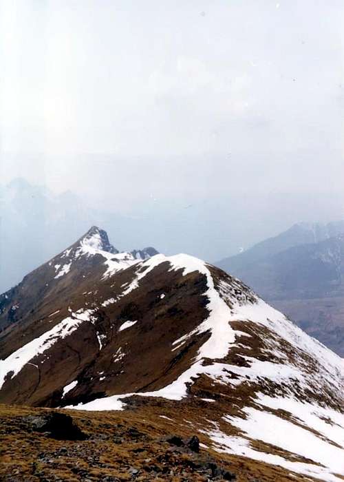
The crest connecting from Aver Becca to Cima of Longhede/La lunga cresta di collegamento tra Becca d'Aver e Cima di Longhede.
9) - (Dal piccolo ponte presso il Villaggio di Issologne in Valle di Saint Barthélemy e tramite la piccola sella 2.300 m~ e traversata alla Cima di Longhede sulla Cresta NE): dalla carrozzabile presso il Villaggio di Issologne (1.514 m; vedere l'Avvicinamento F) - lungo la Valle di Saint Barthélemy) continuare, passando oltre la breve deviazione ad Ovest-nordovest per questo villaggio, e superare anche l'incrocio che si indirizza verso le Frazioni di Lignan (1.633 m), Clémensod (1.655 m) e Saquignod (1.690 m) ad occidente del fondo valle. Raggiungere invece, prima del tornante che porta all'Alpe Verney (1.586 m), un piccolo ponte, che guada il torrente a quota 1.509 m ed una successiva strada poderale, nonché il sentiero subito susseguente. Con questo salire con direzione Sud raggiungendo un primo alpeggio e poi, piegando leggermente più a Sudest, il successivo e più importante di Lavancher (1.779 m). Attraversando con la stessa direzione il bel bosco di abeti e larici, raggiungere il sentiero n° 5, proveniente dall'Alpe Joux (1.803 m), e seguirlo in falso piano ed in quota fino a congiungersi con l'incrocio dei sentieri n° 16/n° 5, che rispettivamente provengono dal Villaggio di Praz e dall'Alpe Les Prèles e concludere tramite i sentieri n° 16/16A con le stesse modalità raggiungendo la sella 2.300 m prima e la Vetta dopo, lungo la Cresta NE (E; 3h'15/3h'45).
10) - (From the small bridge preceding the Issologne Village through a more large western tour and connection with previous route to Longhede Summit): from the carriage one near the Village of Issologne (1.514m; to see the approach F) - along the Valley of Saint Barthélemy) to address through him Southwest in the wood the path n° 3, that, through a long diagonal and overcoming in succession you are small torrents, hands toward a series more narrow hairpin bends reaching the alternative 1.600m~, after having forded other four brooks of modest importance. From this point, abandoning toward Southwest the continuation of the path n° 3 toward the Alp Pesse (1.600m), to brusquely change direction in Northeast and, through the path of connection n° 3D, to reach a hairpin at the end of this sense of march to quota 1.700m~; again turning Southwest to reach the Joux Pasture (1.803m; 1h'00/1h'15), underlying the strata Northwestern of the Ander Mountain (1.931m). Inserting itself on the long path n° 5, that it goes up again toward Northeast up to the earth road "poderale" near the Alp Praz Croux (1.937m), to follow it in the wood with a long crossing on the underlying Northern slope the Pass of the Filon (1.894m) and the Top of Longhede up to the alternative 1.855m below the Slope North of the Aver Becca; here joints to abandon it and, changing angle direction acute toward Southwest, to again take the path n° 16 of the precedents itineraries reaching the wide saddle 2.300m~, from where with the path n° 16A, along the usual NE Crest toward the Peak (2h'00/2h'15; in total 3h'30/4h'00; beautiful excursion, panoramically more profitable).
10) - (Dal piccolo ponte precedente il Villaggio di Issologne con un giro più largo verso occidente verso l'Alpe Joux e collegamento alla precedente via per la Cima di Longhede): dalla carrozzabile presso il Villaggio di Issologne (1.514 m; vedere l'Avvicinamento F)- lungo la Valle di Saint Barthélemy) indirizzarsi a Sudovest nel bosco per mezzo del sentiero n° 3, che, tramite un lungo diagonale e superando in successione sei piccoli torrenti, porta verso una serie di più stretti tornanti raggiungendo il bivio 1.600 m~, dopo aver guadato altri quattro rivi di modesta importanza. Da questo punto, abbandonando verso Sudovest la continuazione del sentiero n° 3 verso l'Alpe la Pesse (1.600 m), cambiare bruscamente direzione in Nordest e, tramite il sentiero di collegamento n° 3D, raggiungere un tornante al termine di questo senso di marcia a quota 1.700 m~; volgendo nuovamente a Sudovest raggiungere l'Alpe Joux (1.803 m; 1h'00/1h'15), sottostante la falde nordoccidentali del Monte Ander (1.931 m).Inserendosi sul lungo sentiero n° 5, che risale verso Nordest fino alla strada poderale presso l'Alpe Praz Croux (1.937 m), seguirlo nel bosco con una lunga traversata sul versante settentrionale sottostante il Col de Filon (1.894 m) e la Cima di Longhede fino al bivio 1.855 m, al di sotto del Versante Nord della Becca d'Aver; qui giunti abbandonarlo e, cambiando direzione ad angolo acuto verso Sudovest, prendere nuovamente il sentiero n° 16 dei precedenti itinerari arrivando alla larga sella 2.300 m~, donde con il sentiero n° 16A lungo la solita Cresta NE alla Vetta (2h'00/2h'15; in totale 3h'30/4h'00; bella escursione, panoramicamente più remunerativa).
11) - (from the Commune of Nus on the fund valley or with intermediary departures from the Fractions of Petit-Fénis and Blavy or from the Alps Her Noueus or Praille on the homonym hill and medium the path of connection for Issologne Village in the Valley of Saint Barthélemy, with an excursion worthy of other times): from the Commune of Nus, near the Fraction Le Bourg, part the path n° 3 that, gone up again the whole Hill of Nus (to see the Approaches F) - and G) -, above described), it is progressively inserted in the Valley of Saint Barthélemy following the ancient Roman Road, and surely already crossed even more by the local Celtic populations in distant epoch, connecting itself with the Village of Issologne. The same salt directly from the fund valley "cutting" in practice the Regional Road for the Valley of Saint Barthélemy; transiting for the Fractions of Plane (718m), Petit-Fénis (939m), Blavy (1.056m), as well as for the Alps Le Noueus (1.181m) and Praille (1.242m) it connects him with the precedent itinerary n° 9 to the Alpe La Pesse (1.600m), from where it goes down on the Village of Issologne (1.514m). We will describe the line among the Pastureis of Praille, last attainable place by cars, and of La Pesse, from where it passes the connection with the preceding itinerary. To the excursionists of good wish (perhaps proper of other times) and endowed with wish, born by a good training, we leave the assignment of "to explore" the inferior lines of the run on the hill, such to surely reserve pleasant surprises, also from the historical, artistic and landscape point of view (notable the Baronial Castle that rises on the rocky promontory overhanging the Fraction of Les Faverges (602m), as soon as out itinerary toward West). From Praille to go up again toward North reaching a earth road "poderale"; to follow it for brief line for then to fold up more toward Northeast through the path that a line of wood crosses gone to fire to the beginning of the Years 2000 and to reach a second of it, well more important and numbered as path n° 3B, that part after the Fraction of Val Dessus, on the carriage one of Saint Barthélemy (1.268m; poster of prohibition). To cross at first toward East and then Northeast and through the wood, doubling on his Western and Northern Slopes the small rocky promontory of the Mont de Pesse or La Pesse (1.708/9m; stings trigonometric), to reach the terminal point of the road same "poderale". From this shortly to the La Pesse Pasture (1.600m), from where he continues with the precedent itinerary n° 10 (E; 4h'00/5h'00 from Praille Pasture; 7h'00/8h'00 from the Fraction of Le Bourg).
11) - (Dal Comune di Nus sul fondo valle o con partenze intermedie dalle Frazioni di Petit-Fénis e Blavy o dalle Alpi Le Noueus o Praille sull'omonima collina e tramite il sentiero di collegamento per Issologne in Valle di Saint Barthélemy, con un'escursione degna di altri tempi): dal Comune di Nus, presso la Frazione Le Bourg, parte il sentiero n° 3 che, risalita l'intera Collina di Nus (vedere gli Avvicinamenti F)- e G)- sopra descritti), si inserisce progressivamente nella Valle di Saint Barthélemy seguendo l'antica Strada Romana, e sicuramente già percorso dalle locali popolazioni celtiche in epoca ancora più lontana, collegandosi con il Villaggio di Issologne. Il medesimo sale direttamente dal fondo valle "tagliando" in pratica la Strada Regionale per la Valle di Saint Barthélemy; transitando per le Frazioni di Plane (718 m), Petit-Fénis (939 m), Blavy (1.056 m), nonché per le Alpi Le Noueus (1.181 m) e Praille (1.242 m) si collega con il precedente itinerario n° 9 all'Alpe La Pesse (1.600 m), donde scende sul Villaggio di Issologne (1.514 m). Descriveremo il tratto tra gli Alpeggi di Praille, ultima località raggiungibile con automezzi, e di La Pesse, da dove passa il collegamento con l'itinerario precedente. Agli escursionisti di buona volontà (forse propria di altri tempi) e dotati di volontà, suffragata da un buon allenamento, lasciamo il compito di "esplorare" i tratti inferiori del percorso sulla collina, tali da riservare sicuramente piacevoli sorprese, anche dal punto di vista storico, artistico e paesaggistico (notevole il Castello Baronale, che sorge sul promontorio roccioso soprastante la Frazione di Les Faverges (602 m), appena fuori del presente itinerario verso Ovest). Da Praille risalire verso Nord raggiungendo una strada poderale; seguirla per breve tratto per poi piegare più verso Nordest, tramite il sentiero che attraversa un tratto di bosco andato a fuoco all'inizio degli Anni 2000, e raggiungerne una seconda, ben più importante e numerata come sentiero n° 3B, che parte dopo la Frazione di Val Dessus sulla carrozzabile di Saint Barthélemy (1.268 m; cartello di divieto). Attraversare dapprima verso Est e poi Nordest ed attraverso il bosco, doppiando sulle sue pendici occidentali e settentrionali il piccolo promontorio roccioso del Mont de Pesse o La Pesse (1.708/9 m; punto trigonometrico), raggiungere il punto terminale della strada poderale medesima. Da questo in breve all'Alpe La Pesse (1.600 m), da dove si continua con il precedente itinerario n° 10 (E; 4h'00/5h'00 dagi Alpeggi di Praille; 7h'00/8h'00 dalla Frazione di Le Bourg).
12) - (From the Praille Alp between Saint Barthélemy Valley and Tall Hill of Nus through the crossing to the Summit of Longhede by the integral and entire Southwest Watershed): from the Alp Praille between the Valley of Saint Barthélemy and the Tall Hill of Nus, through the crossing to the Top of Longhede through the whole Coastline watershed SW): from the Pastures of Praille (1.242m; to see the Approaches F) - and G) -, above statements) to actually continue with the path n° 3 to cross the second earth road "poderale" (coming from the Valley of Saint Barthélemy, over the Fraction of Val Dessus) as in the precedent itinerary n° 11; to abandon to the left (North) the path n° 3 and to the right (South) the "poderale"/path n° 3B that, with wide turn at first in South and then to East, it doubles the Mont of the Pesse on his East side. To continue instead between the wood and clearings and meadows in East direction, crossing the beginning of the crest watershed between the Basin of Verrayes and the Valley of Saint Barthélemy, through run he anchors all inside the Commune of Nus. Reached more aloft again the "poderale", to quota 1.500m~, it is again crossed it continuing on the SW Crest about the Mont La Pesse or The Pesse (1.708/9m) actually to reach its Summit (E; 1h'00/1h'15). From this to continue on the crest with direction Northeast and to reach awry a saddle, said Pesse's Pass, that through the path n° 3C allow the passage among the Pastures of La Bourra or La Bore (1.748m, in the Commune of Verrayes) and of La Pesse (1.600m, in that of Nus); continuing along the crest watershed, through a wooded zone and over passing the small saddle of the Pass of Joux (1.869m), easily to reach the Ander Mountain (E; 1.931m; 0h'45/1h'00 from the Mont La Pesse). With brief descent verse NE to touch the Filon's Pass (1.893/4m), to which from South a earth road "poderale" that departs from the Village of Vi(e)ncorère comes (1.563m), above Grand-Villa (1.407m) in the Commune of Verrayes. Following toward Northeast the continuation of the crest watershed, with steep, exposed and uneven run more and more, the great rocky Shoulder to quota is reached 2.100/25m, immediately to West of the Summit of Longhede, where this "fold" mostly in East. Climbing the West-southwest Ridge of this last with run rather statement ° ° ° ° mini report: after a rectilinear line of crest to overcome a small rocky tooth, follows another line in plain forgery and in light descent, followed by three rocky protuberances that bring to a carving; from this two asperities that precede a square tooth to form of thumb, to which it follows another small saddle precedent a quota and a wider saddle rounded off are climbed that it conducts to the big terminal rocky jump of 100m~ (this whole line of constituent crest the West great Shoulder is attainable from South from the road for the caves of marble from a gully to form of Y that ploughs the whole wood). Revolving this with a crossing to north through the Face North, not without some difficulties (crossed binding and delicate in presence of snow; to the beginning in the winter 2003/4 a rope, in the attempt to cross the whole crest with the snowshoes, you have to return back for the dangerousness; to see Overview and First Ascents), it rejoins us with the final part of the NE Ridge reaching through the same the Top (EE/A; 1h'30/2h'00 from the Pass of Filon; 3h'30/4h'00 from Praille Alp.
12) - (Dall'Alpe Praille tra la Valle di Saint Barthélemy e l'Alta Collina di Nus, tramite la traversata integrale alla Cima di Longhede per mezzo dell'intera Costiera spartiacque Sudovest): dagli Alpeggi di Praille (1.242 m; vedere gli Avvicinamenti F)- e G)-, sopra esposti) proseguire con il sentiero n° 3 sino ad incrociare la seconda strada poderale (proveniente dalla Valle di Saint Barthélemy, oltre la Frazione di Val Dessus) come nel precedente itinerario n° 11; abbandonare a sinistra (Nord) lo stesso sentiero n° 3 ed a destra (Sud) la poderale/sentiero n° 3B che, con largo aggiramento dapprima a meridione e poi ad oriente, doppia il Mont la Pesse sul suo lato Est. Continuare invece tra il bosco e radure prative in direzione Est, percorrendo l'inizio della cresta spartiacque tra la Conca di Verrayes e la Valle di Saint Barthélemy, tramite un percorso ancora tutto all'interno del Comune di Nus. Raggiunta nuovamente la poderale più in alto, a quota 1.500 m~, la si oltrepassa nuovamente continuando sulla Cresta SO del Mont La Pesse o La Pesse (1.708/9 m) sino a raggiungerne la Sommità (E; 1h'00/1h'15). Da questo procedere sulla cresta con direzione Nordest e pervenire ad una sella a monte, detta in loco Col de la Pesse, che tramite il sentiero n° 3C permette il passaggio tra gli Alpeggi di La Bourra o La Bore (1.748 m, nel Comune di Verrayes) e di La Pesse (1.600 m, in quello di Nus); procedendo lungo la cresta spartiacque, tramite una zona boschiva e sorpassando la piccola sella del Col de Joux (1.869 m), facilmente raggiungere il Monte Ander (E; 1.931 m; 0h'45/1h'00 dal Mont La Pesse). Con breve discesa verso NE toccare il Col de Filon (1.893/4 m), al quale da Sud giunge una strada poderale che parte dal Villaggio di Vi(e)ncorère (1.563 m), sopra Grand-Villa (1.407 m) nel Comune di Verrayes. Accompagnando verso Nordest la continuazione della cresta spartiacque, con percorso sempre più ripido, eposto ed accidentato, si raggiunge il grande Spallone roccioso a quota 2.100/25 m, subito ad Ovest della Cima di Longhede, dove questo "piega" maggiormente ad oriente. Salendo la Cresta O-SO di quest'ultima con percorso abbastanza esposto ° ° ° ° mini relazione: dopo un tratto di cresta rettilineo superare un piccolo dente roccioso, segue un altro tratto in falso piano ed in leggera discesa, seguito da tre protuberanze rocciose che portano ad un intaglio; da questo si salgono due asperità che precedono un dente squadrato a forma di pollice, al quale segue un'altra piccola sella precedente una quota ed una più larga sella arrotondata che conduce al gran salto roccioso terminale di 100 m~ (tutto questo tratto di cresta costituente lo Spallone Ovest é raggiungibile da Sud dalla strada per le cave di marmo da un canalone a forma di Y che solca l'intero bosco). Aggirando questo con una traversata a settentrione tramite la Parete Nord, non senza qualche difficoltà (percorso impegnativo e delicato in presenza di neve; all'inizio dell'inverno 2003/4 una cordata, nel tentativo di percorrere l'intera cresta con le racchette da neve, dovette tornare indietro per la pericolosità; vedere Overview e First Ascents), ci si ricongiunge con la parte finale della Cresta NE raggiungendone la Cima (EE/A; 1h'30/2h'00 dal Col de Filon; 3h'30/4h'00 da Praille).
13) - (W-SW Ridge from the Fraction of Vencorère through the Filon Pass from Ve(i)ncorère Village (1.513m) reached through the main road from Grand-Villa (1.407m), into the Western extremity of the Basin of Verrayes, to go up again with direction Northwest through the earth road "poderale" (shortcuts) to the superior Alp Prelaz (1.712m), immediately in East of the Joux Pass (1.869m), where it also finishes the long road "poderale"/path n° 6 already described above; from this through a half dozen of hairpin bends and a diagonal toward left (Northwest) in the terminal part to reach the Filon Pass (= Pass of the Seam; 1.893/4m), wide saddle positioned among the Mount Ander in Southwest and the great West Shoulder of the Summit of Longhede to East and that it allows the transit from the Tall Basin of Verrayes toward the Valley of Saint Barthélemy; (E; 1h'15/1h'30) connecting itself to the W-SW Ridge, about the precedent route n° 13, and with this to conclude in Peak with the same considerations (EE/A; 2h'30/3h'00 all together). ° ° ° ° ° VARIANTS: always in Grand-Villa Fraction with the carriage one for Ve(i)ncorère Village passing for the Village of Vieille (1.450m; here a earth road "poderale" arrives from also the Fractions of Dorinaz and Charr(i)ère and, wanting, she can also be departed from these two places) but, to the elbow winding road before the rectilinear one for Vencorère, to leave the carriage one and to take a road "poderale" toward Northeast that goes up again to the earth "poderale" diagonal"/path n° 6 and with this, turning to West, shortly to reach the Alp of Maisonnette(a) (1.659m). To leave to the left (West) the path n° 6 for Prelaz Pasture, that is undoubled from the earth road continuing more toward West-northwest, and through this last to actually continue to a fork to quota 1.710m~; from this to leave to the right (Northeast) the ramification that climbs to the caves of marble of serpentine, underlying the SW Wall about the Summit of Longhede, and to continue instead on that of left rejoining itself to the alternative with the branch coming from Prelaz Alp. Through the wood and on the fund of a small valley to reach the pass (E; same time; a quarter of now in more departing from Grand-Villa and half time from Dorinaz/Charrière).
13) - (Cresta O-SO dalla Frazione di Vencorère tramite il Col de Filon): dal Villaggio di Ve(i)ncorère (1.513 m) raggiunto con la carrozzabile da Grand-Villa (1.407 m), all'estremità Occidentale del Bacino di Verrayes, risalire con direzione Nordovest tramite la strada poderale (scorciatoie) alla soprastante Alpe Prelaz (1.712 m), subito ad oriente del Col de Joux (1.869 m), ove termina anche la lunga strada poderale/sentiero n° 6 già descritta sopra; da questa per mezzo di una mezza dozzina di tornanti ed un diagonale verso sinistra (Nordovest) nella parte terminale raggiungere il Colle del Filone, larga sella posizionata tra il Monte Ander a Sudovest e lo Spallone Ovest della Cima di Longhede e che permette il transito dall'Alta Conca di Verrayes alla Valle di Saint Barthélemy, (1.893/4 m; E; 1h'15/1h'30) collegandosi alla Cresta O-SO, descritta nel precedente itinerario n° 13, e con questa concludere in Vetta con le medesime considerazioni (EE/A; 2h'30/3h'00 in totale). ° ° ° ° ° VARIANTI: sempre da Grand-Villa con la carrozzabile per Vincorère passando per il Villaggio di Vieille (1.450 m; qui arriva anche una poderale dalle Frazioni di Dorinaz e Charr(i)ère e, volendo, si può partire anche da queste due località) ma, al tornante a gomito prima del rettilineo per Vencorère, lasciare la carrozzabile e prendere una strada poderale verso Nordest che risale alla poderale "diagonale"/sentiero n° 6 e con questo, voltando ad Ovest, in breve raggiungere l'Alpeggio di Maisonnette(a) (1.659 m). Lasciare a sinistra (Ovest) il sentiero n° 6 per Prelaz, che si sdoppia dalla strada poderale continuando più verso Ovest-nordovest, e tramite quest'ultima continuare sino ad un bivio a quota 1.710 m~; da questo lasciare a destra (Nordest) la ramificazione che sale alle cave di marmo di serpentino, sottostanti la Parete SO della cima di Longhede, e proseguire invece su quello di sinistra ricongiungendosi al bivio con il ramo proveniente da Prelaz. Tramite il bosco e sul fondo di un piccolo vallone raggiungere il colle (E; stesso tempo; un quarto d'ora in più partendo da Grand-Villa e mezz'ora da Dorinaz/Charrière).
Difficulties
This route can be considered E.
L'itinerario è classificato E.
Equipment
Standard mountaineering equipment also, in the presence of abounding snowy slope, by ski or snowshoes.
Da escursionismo ed, in presenza di buon innevamento, tramite sci on racchette da neve.
Campings
Remember that free camping is forbidden (except for emergency reasons, over 2.500m, from darkness until dawn).
Mountain Conditions
You can get meteo information at the official site of the Regione Valle d'Aosta:
Parents refers to a larger category under which an object falls. For example, theAconcagua mountain page has the 'Aconcagua Group' and the 'Seven Summits' asparents and is a parent itself to many routes, photos, and Trip Reports.

 8478 Hits
 89.01% Score
 28 Votes