Premise
I have been requested to split my previous Area page of Gran Paradiso Group because of its too big dimensions: consequently its consultation was difficult in particular for the SPers without fast connection to the net.
Links to Other Pages
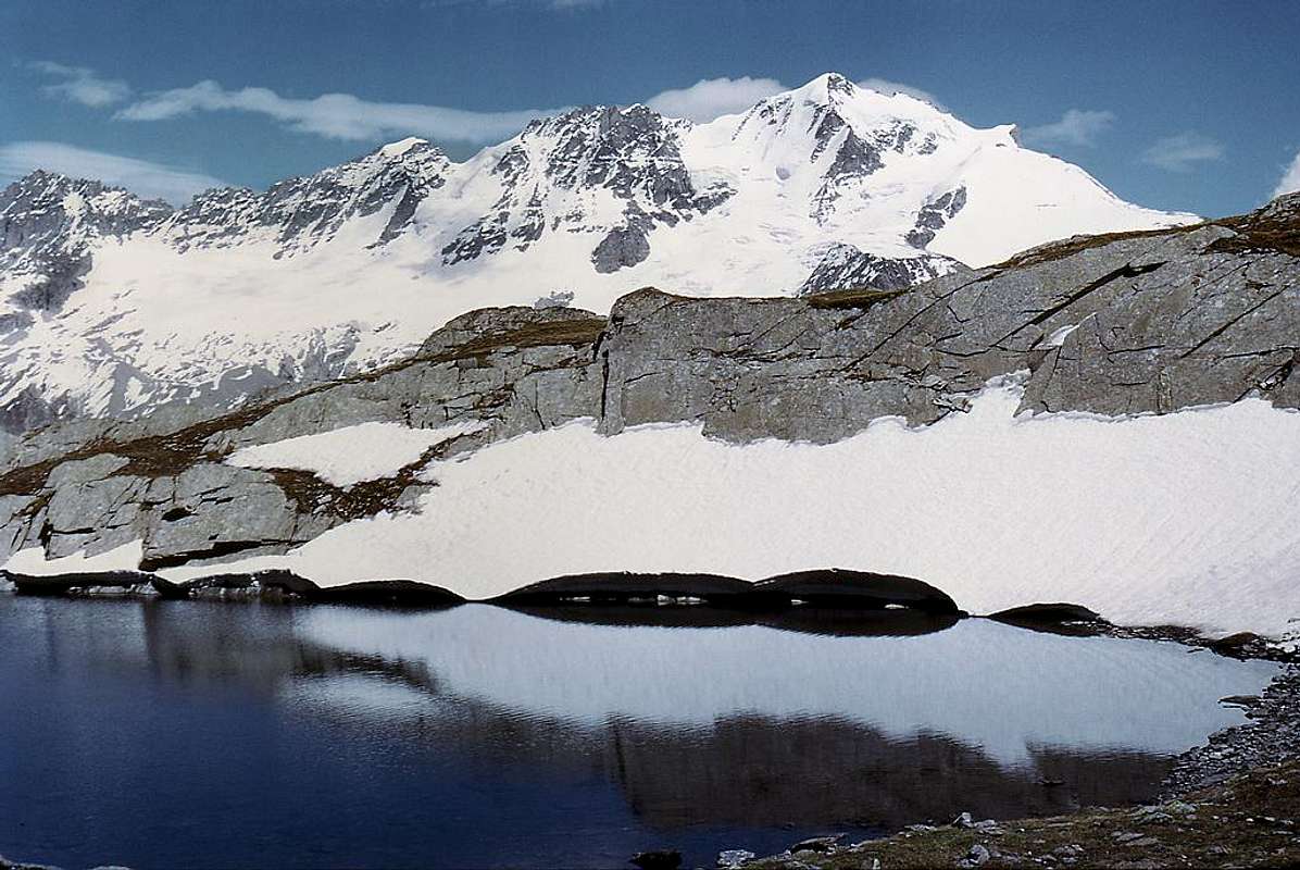
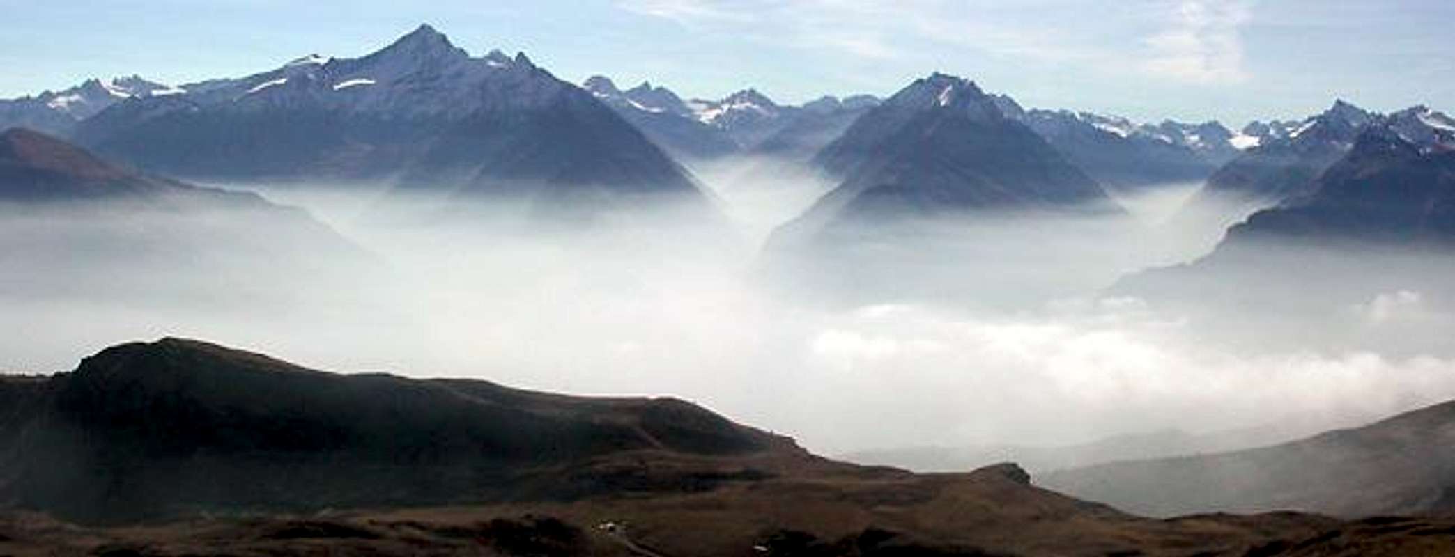
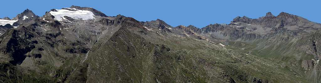
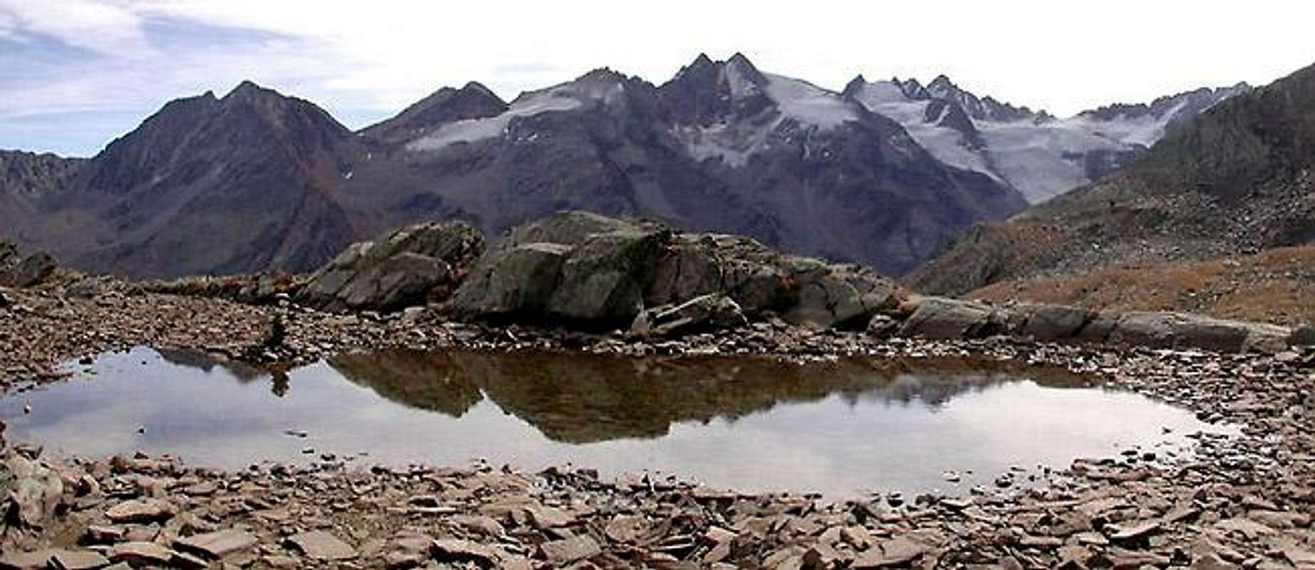
![Western side of Gran Paradiso range]() |
|
Western side of Gran Paradiso range, seen from the shore of a small lake in the Vallone delle Meyes (July 1974).
From left one can recognize: Herbetet, Punta Budden, Becca di Montandayné, Piccolo Paradiso, Gran Paradiso, il Roc, Becca di Moncorvé |
|
Overview
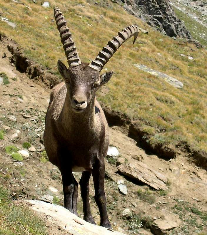
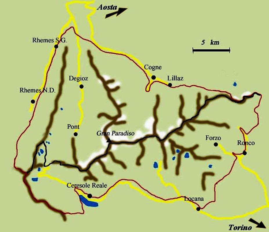
The Gran Paradiso group includes the only 4000 meter summit entirely in Italian territory, that is the namesake summit that reaches 4061 meters. It is one of the most important groups of the Western Alps; in particular it belongs to Alpi Graie (Graian Alps). Its western and eastern boundaries are not exactly identified: the geological limits are generally placed W at Col del Nivolet (2612m) and E at Col dell'Arietta (2939m), whereas the debated geographical limits are placed W at Col di Rhemes or Punta Basei (3338m), E at Rosa dei Banchi (3164m) or Bec Pragelas (2908m). In the latter case, the borders coincide with the ones of Parco Nazionale del Gran Paradiso, the first Italian National Park instituted in the year 1922, approximately on the area that had been the Royal Hunting Preserve. King Vittorio Emanuele II had wanted the huntingpreserve, in order to prevent the extinction of steinbock (Capra ibex) and chamois (Rupicapra rupicapra), of which he was an inveterate hunter.
![]()
Handmade map of the Gran Paradiso National Park. In red the limits of the Park, in black the border between the northern sector (Valle d'Aosta) and the southern one (Piemonte) |
Both group and park extend over Valle d'Aosta and Piemonte, whose border is just the ridge, belonging to the Gran Paradiso group and running from west to east.
In Valle d'Aosta, a series of ranges developing in the south-north direction separates the three principal valleys; from the west they are: Val di Rhemes, Valsavarenche and valle di Cogne, which in turn originates Valnontey (that is the heart of the Group), Valeille, and the secondary valleys of Bardoney, Acque Rosse and Urtier.
![]()
View from North of the three valleys belonging to the Gran Paradiso Group: Val di Cogne, Valsavarenche, Val di Rhêmes |
|
Getting There
Valle di Cogne
- From Torino, Milano, etc: Motorway A5. Exit at Aosta Ovest. Drive to the near Aymavilles. Follow the directions for Valle di Cogne.
- From Switzerland: through the Grand Saint Bernard Tunnel or the namesake Pass.Drive to Aosta, then follow the direction for Courmayeur on SS.26. Just after Sarre, turn to the left, in the direction of Valle di Cogne.
- From France: through Mont Blanc Tunnel or Petit St. Bernard Pass. It isn't necessary to take motorway A5: you can drive on SS.26, in the direction of Aosta. Before arriving at the village of Sarre, turn right following the sign for Valle di Cogne.
After Aymavilles, the Regional Road n° 47 crosses the villages of Vieyes, Epinel and Cretaz and after about 25 Km arrives at Cogne (1534m). From Cogne you can get the villages of Lillaz (1617m) or Valnontey (1666m).
Val di Rhêmes and Valsavarenche
- From France, through the Mont Blanc Tunnel or the Col du Petit Saint Bernard: you can drive on SS.26, following the direction for Aosta and, before arriving in Villeneuve, turn right towards Introd. Alternatively, you can take Motorway A5 (at Courmayeur or Morgex) and exit at Aosta Ovest.
- From all other directions: get to the Aosta Ovest exit of motorway A5. Then drive along SS.26 Aosta, direction Courmayeur, and just after Villeneuve turn left towards Introd.
Shortly after Introd, you arrive at a junction:
- you can go straight following the sign "Val di Rhêmes" and then drive through Rhêmes Saint Georges as far as Rhêmes Notre Dames; after the main village, Bruil (1723m), the road reaches the hamlet of Pellaud, then becomes narrower and may be followed as far as the vast parking in view of Thumel (1880m). From here the road follows but the transit is forbidden.
- or you can turn left, entering in Valsavarenche, and through many villages (Degioz, Eaux Rousses, etc) you can arrive at Pont (1978m) where the road ends.
|
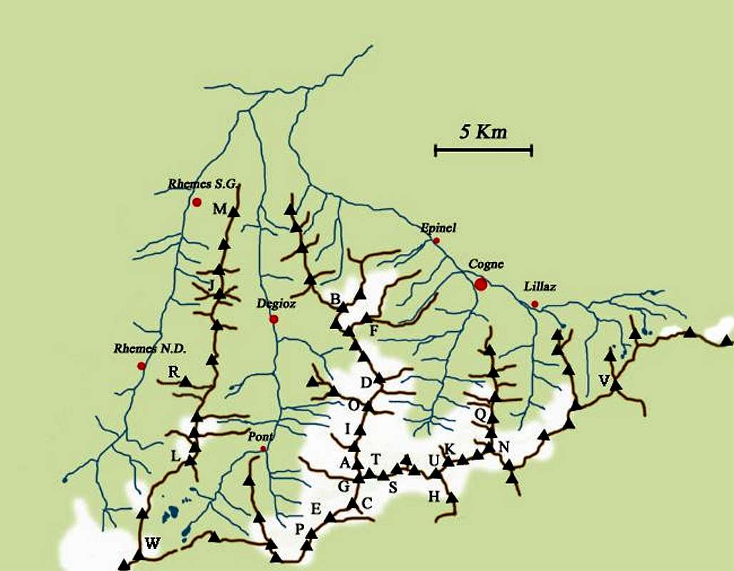
Summits of the Gran Paradiso GROUP
![]()
Summits of the Gran Paradiso GROUP reported in the previous map |
| 1_Punta Galisia 3346 m | 28_Punta Rossa della Grivola 3630 m |
| 2_Punta Basei 3338 m | 29_La Grivola 3969 m |
| 3_Punta Gran Vaudala 3272 m | 30_Grivoletta 3514 m |
| 4_Taou Blanc 3438 m | 31_Gran Nomenon 3488 m |
| 5_Aouillé 3440 m | 32_Mont Favret 3173 m |
| 6_Cima di Entrelor 3430 m | 33_Punta Valletta 2793 m |
| 7_Punta Percià 3227 m | 34_Becca Piana 2271 m |
| 8_La Roletta 3384 m | 35_Punta Ceresole 3777 m |
| 9_Punta Bianca 3427 m | 36_Testa della Tribolazione 3642 m |
| 10_Punta Bioula 3414 m | 37_Testa di Valnontey 3562 m |
| 11_Punta del Ran 3272 m | 38_Becca di Gay 3621 m |
| 12_Punta Chamoussière 2942 m | 39_Becco Meridionale della Tribolazione 3360 m |
| 13_Monte Paillasse 2414 m | 40_Roccia Viva 3650 m |
| 14_Cima dell'Arolley 2996 m | 41_Torre del Gran San Pietro 3692 m |
| 15_Cima di Seiva 3075 m | 42_Punte Patri 3581 m |
| 16_Punta Fourà 3411 m | 43_Punta Valletta 3356 m |
| 17_Mare Pércia 3385 m | 44_ Punta di Valmiana 3244 m |
| 18_Denti del Breuil 3454 m | 45_Punta Fenilia 3053 m |
| 19_Becca di Monciair 3544 m | 46_Punta d'Ondezana 3452 m |
| 20_Ciarforon 3642 m | 47_Becco di Valsoera 3369 m |
| 21_La Tresenta 3609 m | 48_Punta delle Sengie 3408 m |
| 22_Becca di Moncorvè 3875 m | 49_Monveso di Forzo 3322 m |
| 23_Gran Paradiso 4061 m | 50_Grande Arolla 3246 m |
| 24_Piccolo Paradiso 3923 m | 51_Punta della Tsesère 3117 m |
| 25_Becca di Montandayné 3838 m | 52_Torre di Lavina 3308 m |
| 26_Herbetet 3778 m | 53_Punta di Acque Rosse 2952 m |
| 27_La Gran Serra 3552 m | 54_Punta Nera 3064 m | |
Northern Sector: North-South Ridges
|
In black: summits In blue: passes In underscored bold: summits posted on SP (linked to their related page)
|
Watershed Valle di Rhêmes-Valle dell'Orco & Valle di Rhêmes-Valsavarenche
Watershed VALLE di RHÊMES-VALSAVARENCHE: ENTRELOR Subgroup  |
- Punta Leynir
(or Vaudaletta)
S. 3224 m / N. 3235 m
|
![]()
 |
|
|

 |
 It connects Vallone della Vaudaletta (Val di Rhêmes) with Vallone del Leynir (Nivolet basin) |
|


 |
![]()
Placed between Colle Leynir and Colle dell'Aouillè, it is the southernmost summit of the set of three:
Taou Blanc - Aouillè - Entrelor, all having about the same height (3438m /3440m /3430m) |
- Colle dell'Aouillè 3327 m
|
![]() |
|
|
![]()
 |
|
|
 |
Two ridges start from here:-
![]() the first one directed westwards separates the hanging valleys ("valloni") of Vaudaletta and Entrelor and culminates with Becca di Tsambeina 3162m, where furtherly splits up into three branches:
the first one directed westwards separates the hanging valleys ("valloni") of Vaudaletta and Entrelor and culminates with Becca di Tsambeina 3162m, where furtherly splits up into three branches:- NNW, ending with la Treutse 2576m
- NW, ending with an unnamed summit 2680m
- WSW ending with Becca Nouvaz 2871m
-
![]() the second ridge, named Costa delle Meyes (or Costa dell'Aouillè), after an unnamed summit at the quote 3357m goes eastwards and culminates with Punte delle Meies: W. 3155m/ Central 3103m/ E. 3010m
the second ridge, named Costa delle Meyes (or Costa dell'Aouillè), after an unnamed summit at the quote 3357m goes eastwards and culminates with Punte delle Meies: W. 3155m/ Central 3103m/ E. 3010m
|
|
 |
|
- Punta Percià (Fourà)
S. 3227m / N. 3212m
|
 |
From the Northern summit a ridge, named Costa la Manteau (or Mentò), starts eastwards, separating Vallone delle Meyes from Vallone del Nampio, descends to Colle della Mentò 2795m and, after Testa della Mentò (or Chandelly) 2812m, declines towards the valleybottom |
|
 |
![]() The access from Val di Rhêmes is steeper than the one from Vallone del Nampio (Valsavarenche) The access from Val di Rhêmes is steeper than the one from Vallone del Nampio (Valsavarenche) |
|
Watershed Valsavarenche-Valle di Cogne
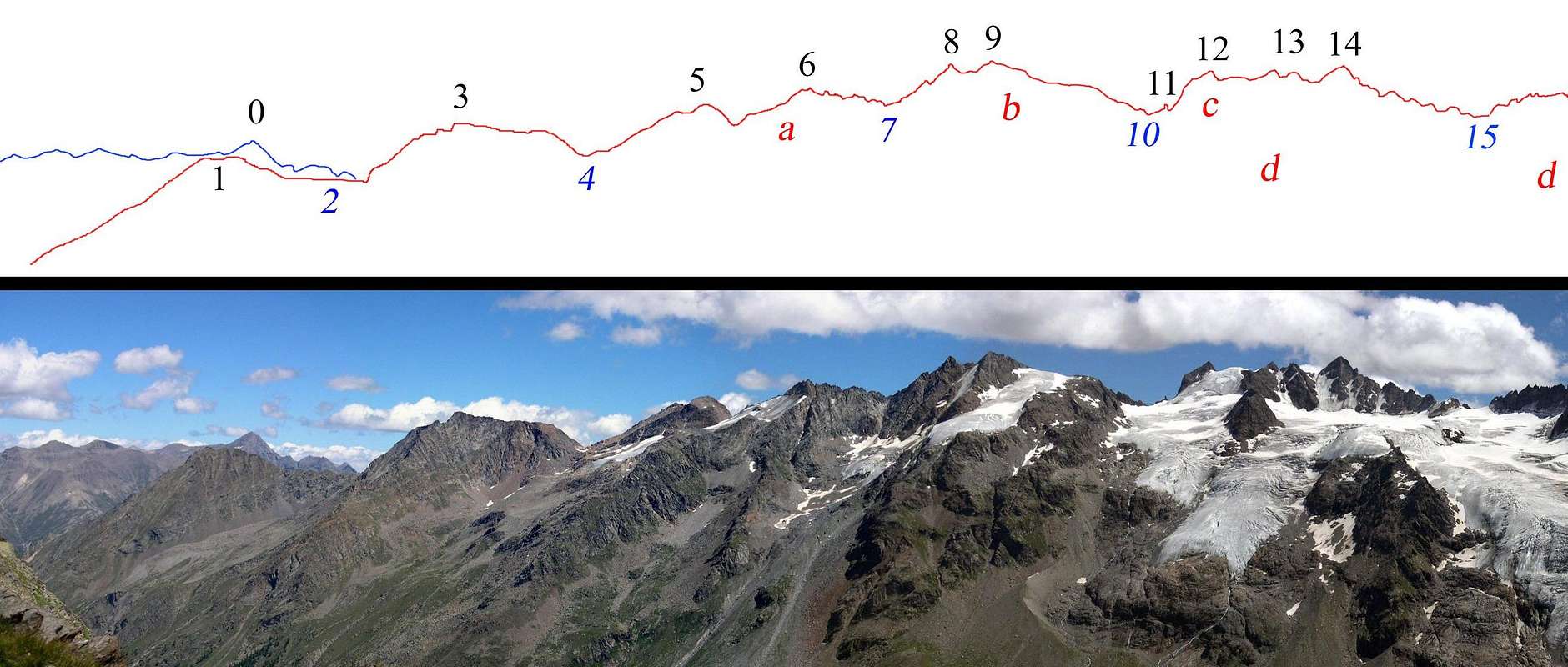
Watershed Valnontey-Valeille
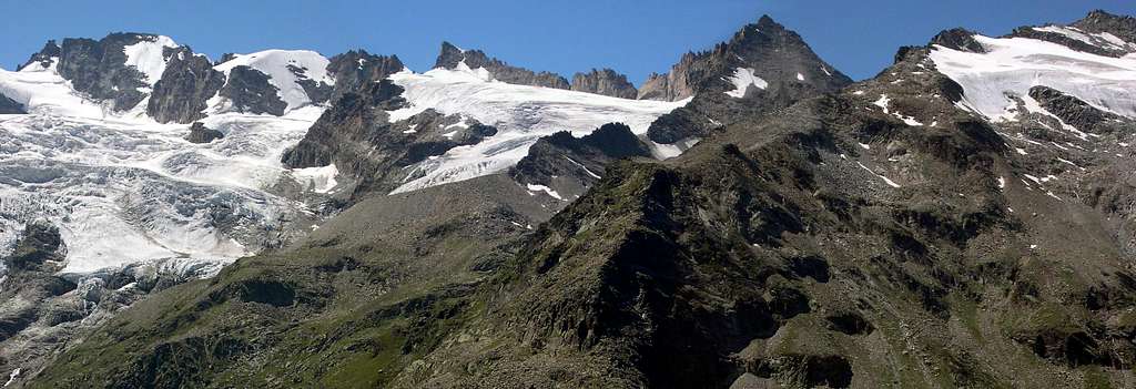
![]()
Identification of summits, passes and glaciers belonging to the watershed Valnontey-Valeille. In the far background, on the left, Punta Tersiva (view from Bivacco Leonessa 2910m) |
Profile of the Watershed Valnontey -Valeille |
SUMMITS and PASSES | GLACIERS |
| 0 – Punta Tersiva 3513 m
| a - Ghiacciaio di Valletta |
| 1 – Punta Fenilia 3053 m |
b - Ghiacciaio di Patrì |
| 2 – Colle della Granzetta 2933 m |
c - Ghiacciaio del Coupè di Money |
| 3 – Punta di Valmiana 3244 m |
d - Ghiacciaio di Money |
| 4 – Colle di Valmiana 3093 m |
|
| 5 – Punta Valletta N. 3318 m / S. 3356 m |
| 6 – Punta Tsissetta 3419 m |
| 7 – Colle Patrì 3361 m |
| 8 – Punta Patrì N. 3561 m | | 9 – Punta Patrì S. 3581 m |
| 10 – Colle Coupè di Money 3393 m |
| 11 – Dito degli Apostoli 3439 m |
| 12 – Torre di S. Orso 3618 m |
| 13 – Torre di S. Andrea 3651 m |
| 14 – Torre del Gran San Pietro 3692 m |
| 15 – Colle di Money 3443 m |
|
Watershed Valeille-Vallone di Bardoney
Books and Maps
|
BOOKS - E. Andreis, R. Chabod, M.C. Santis "Guida dei Monti d'Italia - Gran Paradiso Parco Nazionale" Club Alpino Italiano / Touring Club Italiano, 1980 (in Italian)
- L. Zavatta Le valli del Gran Paradiso e la Valgrisenche, guide dell'Escursionista, 2003 (in Italian)
MAPS - Kompass Gran Paradiso Valle d'Aosta Sentieri e rifugi-Carta turistica 1:50000
- IGC-Istituto Geografico Centrale Valsavarenche Val di Rhêmes Valgrisenche Carta dei sentieri e dei rifugi 1:25000
- IGC-Istituto Geografico Centrale Gran Paradiso La Grivola Cogne Carta 1:25000
- I.G.M. -Istituto Geografico Militare Foglio 41 1:25000 I NO La Grivola - I SO Gran Paradiso - I NE Cogne - I SE Torre del Gran San Pietro III NE Colle del Nivolet - IV NE Rhêmes Saint George - IV SE Rhêmes Notre Dame
|
Meteo
You can get meteo information at the official site of the Regione Valle d'Aosta
Valle d'Aosta Meteo
Weather forecasting concerning both Piemonte and Valle d'Aosta can be found at nimbus.it |
Camping
|
There are many camping sites in all the northern valleys of Gran Paradiso Park: Valle di Rhêmes, Valsavarenche and Valle di Cogne, going from West to East.
As already pointed out, remember that free camping is forbidden (except for emergency reasons, over 2500m, from darkness until dawn). |
Red Tape
|
Within the borders of the P.N.G.P. (Parco Nazionale del Gran Paradiso), at the moment (summer 2005), dogs generally are not allowed, except on a pair of trails, and camping is forbidden (except above 2500m from sunset till dawn).
No fees are due.
|
Important Information
Useful Numbers
- Soccorso Alpino Cogne (SAR) Tel. 3482685406.
- Protezione Civile Valdostana località aeroporto 7/A Saint Christophe (Ao) Tel. 0165-238222.
- Bollettino Meteo (weather info) Tel. 0165-44113.
- Unità Operativa di Soccorso Sanitario Tel. 118.
|
External links
- P.N.G.P. official site
It's the official site of the Parco Nazionale del Gran Paradiso (in five languages)
- parco.nazionale.gran.paradiso
Another complete site concerning the Gran Paradiso National Park, with a lot of information (in three languages)
|


 32207 Hits
 95.35% Score
 52 Votes