
-
 8202 Hits
-
 85.87% Score
-
 21 Votes
|
|
Mountain/Rock |
|---|---|
|
|
45.60305°N / 7.27085°E |
|
|
Aosta Valley |
|
|
Mountaineering |
|
|
11529 ft / 3514 m |
|
|
Overview
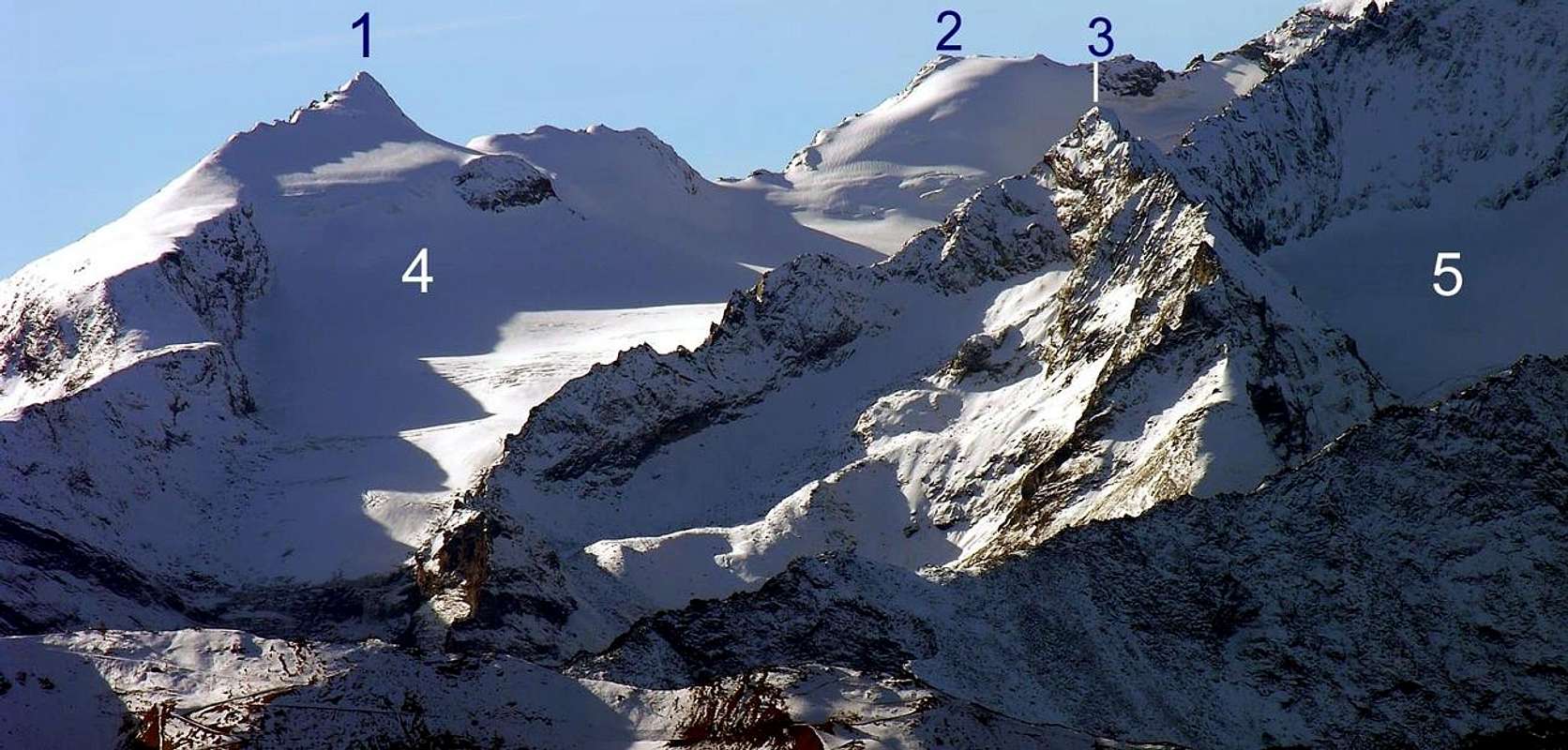
Positioned between the very famous Grivola Mountain (3.969m) and the Crevasse Point (3.303m) on NE spur from Grivola to Traso Pass (2.877m), Traso Point (3.127m) and Grand Eyvia Stream, near to Epinels Village. Good views, frontally, to Grivola, to Trajo and Nomenon Glaciers and, in the North direction, towards the whole Monte Emilius Group.
Situata tra la celeberrima Grivola (3.969 m) e la Punta Crevasse (3.303 m) sul contrafforte NE che dalla Grivola scende al Colle del Traso (2.877 m), all'omonima Punta (3.127 m) e al Torrente Grand Eyvia (Grande Acqua), vicino al Villaggio di Epinel. Ottimo punto panoramico sulla vicina Grivola, sui ghiacciai del Traso o Trajo di Nomenon e sull'intero Gruppo del Monte Emilius.
First Ascents
- First on the summit (from Traso Pass by North Ridge and West Slope: W. A. B. Coolidge, F. Gardinier and mountain's guides Christian Junior Almer and R. Almer, (Aug 21th, 1889).
- First in winter: Unknown.
- N Arête from Punta Crevasse: G. Garrone and G. Scotti, (Sep 04th, 1910).
- E-NE Ridge: G. Yeld and mountain's guides of Valtournenche F. Pession and A. Pellissier, (Aug 11th, 1892).
 |
Getting There
BY CAR:- From Torino, Milano, etc: Motorway A5. Exit at Aosta Ovest. Drive to the near Aymavilles. Follow the directions for Valle di Cogne.
- From Switzerland: through the Grand Saint Bernard Tunnel or the namesake Pass. Drive to Aosta, then follow the direction for Courmayeur on SS.26. Just after Sarre, turn to the left, in the direction of Valle di Cogne.
- From France: through Mont Blanc Tunnel or Petit St. Bernard Pass. It isn't necessary to take Motorway A5: you can drive on SS.26, in the direction of Aosta. Before arriving at the Village of Sarre, turn right following the sign for Valle di Cogne. After Aymavilles, the SR.47 crosses the Villages of Vieyes, Epinel and Cretaz and after about 25 Km arrives at Cogne (1.534m). From Cogne you can get the Village of Valnontey (1.666m).
- Aeroporto "Corrado Gex" Saint Christophe (Aosta).
Route A
From VITTORIO SELLA REFUGE (for the Nera Pass, Clochettes Pass and SW Arête): From Nera Pass to go down and to cross by Northeast direction the Trajo Glacier towards the rocky wall bellow the Clochettes Pass (3.477m), near Mario Balzola Bivouac; to climb up by steep rocks but broken and earth-lichens. From the pass to cross in NE and by Southwest Crest, easily in the Summit (F+/PD-; 1h'30/2h'00).Dal Colle della Nera scendere e traversare con direzione NE il ghiacciaio del Trajo verso la parete rocciosa sottostante il Colle delle Clochettes (3.477 m), vicino al Bivacco Mario Balzola, risalire su rocce ripide, ma rotte con terriccio. Dal colle attraversare verso NE con la Cresta SW e facilmente sino in vetta (F+/PD-; 1h'30/2h'00).
Route B
From LUCIANO GRATTON BIVOUAC (for the E-NE Arête): From Luciano Gratton bivouac (3.198m), near Pousset Pass in North-Northeast Buttress of the Punta Rossa (3.201m) to descent (by 90 meters~) in Trajo Glacier and to cross in West upon the "seracs" (attention crevices, generally in horizontal radial arrangement) and to come up by easy rocks to Grivoletta Pass (3.322m). To climb by the easy E-NE Crest in the Summit (200 meters; amusing) (EE/A; PD-; 2h'00/2h'30).Dal Bivacco Luciano Gratton (3.198 m), presso il Colle del Pousset (3.201 m), sul Contrafforte N-NE della Punta Rossa, scendere (per 90 metri~) sul ghiacciaio del Trajo e traversare verso W sopra la seraccata (attenzione ai crepacci) e salire su rocce facili al Colle della Grivoletta (3.322 m). Arrampicare per circa 200 metri la facile divertente Cresta E-NE (EE/A; PD-; 2h'00/2h'30).
Difficulties
The routes can be rated as EE/A/F+/PD-.Da alta montagna, corda, piccozza e ramponi.
MAPS:
Huts
- Rifugio Vittorio Sella (2.584 m.) Conca di Lauson (Cogne) Tel.: 0039/0165/74310 eMail: info@rifugiosella.com
- Bivacco LUCIANO GRATTON (3.198 m) 9 posti
![]()
![]()


Campings
- Wild camping in the Parco Nazionale del Gran Paradiso is strictly forbidden!!!
Red Tape
Within the borders of the P.N.G.P. (Parco Nazionale del Gran Paradiso), at the moment (summer 2004), dogs generally are not allowed, except on a couple of trails, and camping is forbidden (except for climbers from sunset till dawn). No fees are due.Mountain Condition
- You can get weather forecasts at the official site of the Regione Valle d'Aosta:
- Valle d'Aosta Meteo
Webcam
- WEBCAM on Aosta Valley:
- Webcam
Books and Maps
BOOKS:- "Guida dei Monti d'Italia-Gran Paradiso Parco Nazionale" E. Andreis, R. Chabod, M. C. Santis, Club Alpino Italiano/Touring Club Italiano, prima Ed. 1939; seconda Ed. 1963; terza Ed. 1980.
- "I Rifugi della Valle d'Aosta" di Stefano Ardito, Ed. Guide iter, Febbraio 2003.
- "Guida delle Alpi Occidentali", di Giovanni Bobba e Luigi Vaccarone C.A.I. Sezione di Torino Volume II (parte II), 25 Maggio 1896.
- "Rifugi e bivacchi in Valle d'Aosta", di Cosimo Zappelli aggiornata da Pietro Giglio, Musumeci Editore, Luglio 2002.
 |
 |
 |
 |
- Kompass "Gran Paradiso Valle d'Aosta Sentieri e Rifugi" Carta Turistica 1:50.000.
- Enrico Editore Ivrea-Aosta "Gruppo del Gran Paradiso" 1:50.000.
- L'Escursionista "Valle di Cogne Carta dei Sentieri" 1:25.000.
- L'Escursionista "Tour de la Vallée de Cogne Grand Paradis" 1:25.000.
- I.G.C. Istituto Geografico Centrale "Parco Nazionale del Gran Paradiso" 1:50.000.
- Studio F.M.B. "Gran Paradiso" Bologna 1:50.000.
Important Information
- REGIONE AUTONOMA VALLE D'AOSTA the official site.
- FONDAZIONE MONTAGNA SICURA Villa Cameron, località Villard de la Palud n° 1 Courmayeur (AO) Tel: 39 0165 897602 - Fax: 39 0165 897647.
- SOCIETA' GUIDE ALPINE DI COGNE Tel. 347/9473526 – 328/1373728.
- A.I.NE.VA. (Associazione Interregionale Neve e Valanghe).
- A.IA.T. Cogne Gran Paradis via Bourgeois n° 34 Tel. 0165-74040. E-mail: aiat@cogne.org
- Ezio Sport articoli sportivi - via Bourgeois n° 64 Tel. 0165-74204.
Useful numbers
- Soccorso Alpino Cogne (SAR) Tel. 3482685406.
- Protezione Civile Valdostana località Aeroporto n° 7/A Saint Christophe (Ao) Tel. 0165-238222.
- Bollettino Meteo (weather info) Tel. 0165-44113.
- Bollettino Valanghe Tel. 0165-776300.
- Unità Operativa di Soccorso Sanitario Tel. 118.