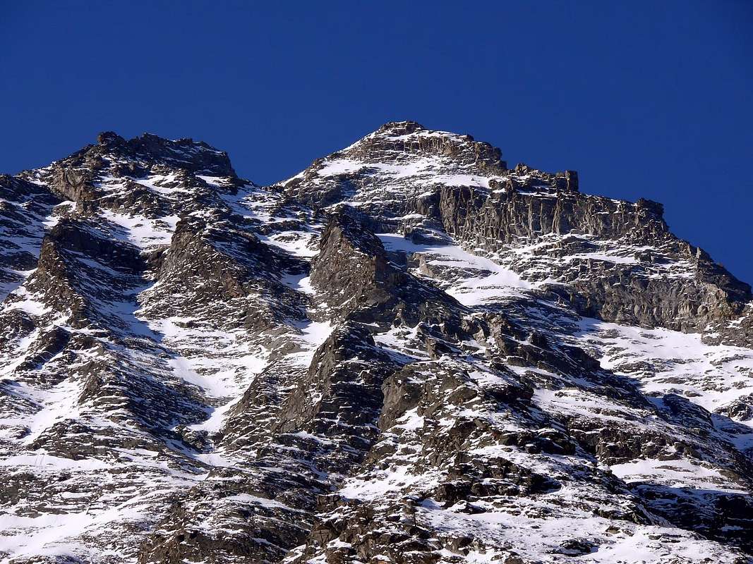
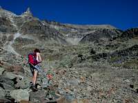
Punta di Bioula is the highest mountain in Northside of the ridge dividing Valsavarenche from the adjacent Val di Rhêmes. Due to this strategic position, very great sightseen on
ALL major Val d'Aosta Mountains (M. Blanc, Gr. Combin, Matterhorn, Rosa, Grivola and Gran Paradiso ... and many others) is offered. This wild summit is located in the heart of Gran Paradiso National park. Very few people climb it, because it take about 6 hours (at least for simple hikers) to climb and 4 hours and half to descent. Other difficulties is the footpath, sometimes hidden in the big stonefield or covered form the grass. Great possibilites to meet wild animals of the Park. Only for expert and well trained hikers. Very long route! Beautiful and profitable also the crossings on the ridge, even if longer than not difficult and in any case never banal.
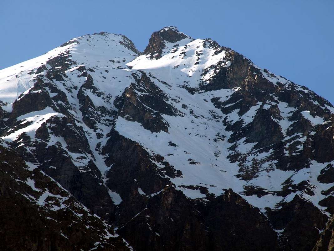
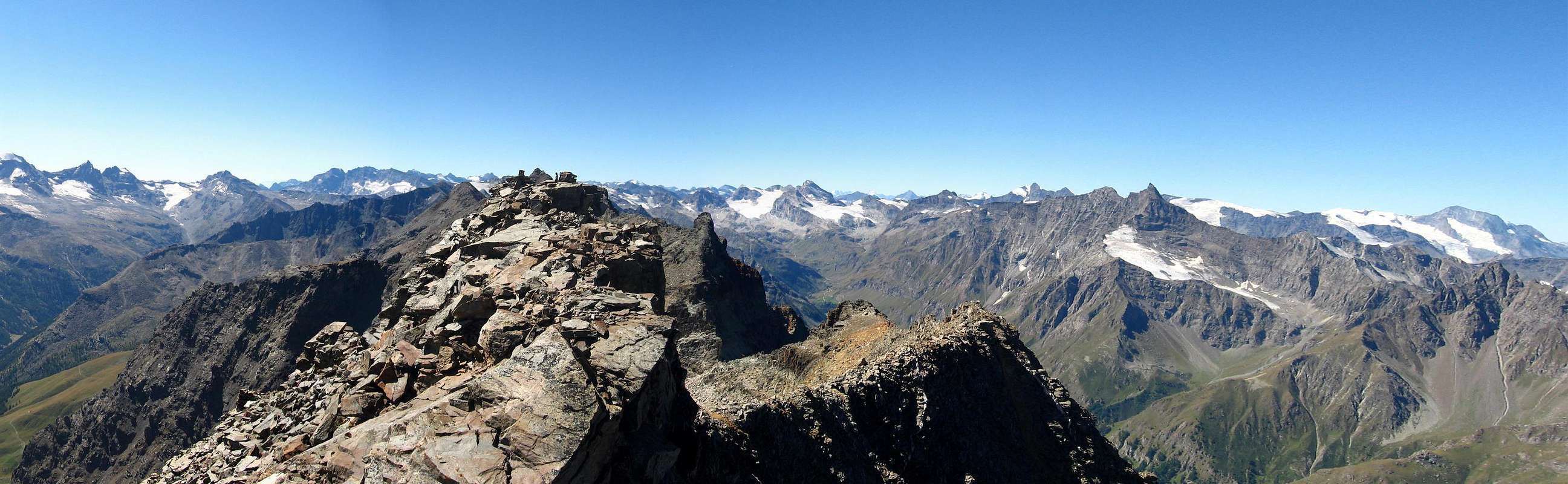
They can be partial, reaching in succession from North to South Tours de Notre Dame (3.355m) - Punta Bianca (3.440m) - Clocher de Djuan (3.324m) - La Roletta (3.385m) or complete reaching the Col de Sort (2.964m) at the end of the same watershed. ![]()
La Punta Bioula risulta come la montagna più alta a Nord della cresta che divide la Valsavarenche dall'attigua Val di Rhêmes. Grazie a questa posizione strategica, viene offerto un ottimo panorama su TUTTE le principali montagne della Valle d'Aosta (Monte Bianco, Grand Combin, Cervino, Rosa, Grivola e Gran Paradiso ... e molte altre). Questa selvaggia vetta si trova nel cuore del Parco Nazionale del Gran Paradiso. Pochissime persone la salgono, perché richiede un impegno di circa 6 ore (almeno per quanto cencerne semplici escursionisti) per salire e 4 ore e mezzo per la discesa. Altre difficoltà consistono nell'individuazione del sentiero, a volte nascosto nella grande pietraia o perché ricoperto dall'erba. Ottime possibilità di incontrare animali selvatici del Parco. Gita adatta esclusivamente ad escursionisti esperti e ben allenati. A causa del percorso molto lungo! Belle nonché remunerative anche le traversate in cresta, anche se più lunghe che non difficili e comunque mai banali. Possono essere parziali, raggiungendo in successione da Settentrione a Meridione Tours de Notre Dame (3.355 m) - Punta Bianca (3.440 m) - Clocher de Djuan (3.324 m) - La Roletta (3.385 m) oppure complete raggiungendo al termine del medesimo spartiacque il Col de Sort (2.964 m).
First Ascents
- First on the summit: Unknown.
- In winter: Unknown.
- South-southwest Ridge (to Tour de Notre Dame): Michele Baratono and Federico Chabod, September 01th, 1924, in descent from Punta Bioula.
- Southeast Slope (Normal Route): Unknown.
- West Wall: Leonardo Cossard and Remo Chabod, June 1938.
- Northwest Crest and West Face: Pier Francesco Quaini, lone, August 31th, 1914, in ascent from Western Bioula Basin.
- Northern Ridge: Lorenzo Rossi di Montelera with Guide Lindo Lucianaz, August 06th, 1976, in ascent from Rhêmes Creton and through Nequedé Pass.
- East-southeast Ridge: Osvaldo Cardellina, lone, September 24th, 1988, in ascent from Eaux Rousses and through Quotas 2.795, 3.125 meters.
![]() Just to the right or North-northwest by Fourquin de Bioula, by Osw 2016
Just to the right or North-northwest by Fourquin de Bioula, by Osw 2016
VARIOUS FIRST in ALL SUMMITS and GREAT TRAVERSES or CROSSINGS
- Tours de Notre Dame (3.355m): Michele Baratono and Federico Chabod, September 01th, 1924, from Lorguibet Pass (3.185m) and East Face. Integral ascent by Northern Ridge: Domenico Caresio, Damiano Gratton and Franco Perino; August 24th, 1968.
- Punta Bianca (3.440m): unknown or surely by Giovan Battista Bozzino, Summer 1911, from Djuan Basin by Eastern Crest.
- Clocher de Djuan (3.324m): Michele Baratono, Renato Chabod, Amilcare Crétier and Leonardo Pession, July 16th, 1926, with traverse to Punta Bianca. Second: Camillo Bianco, Emilio Micheli and Emilio Muller, August 1935; third: Osvaldo Cardellina, lone and secured from bottom by Giuseppe Lamazzi, August 18th, 1985.
- La Roletta (3.385m): unknown.
- First Crossing Bioula-Bianca-Clocher-La Roletta: Camillo Bianco, Emilio Micheli and Emilio Muller, August 1935.
- First Crossing Nequedé Pass-Bioula-Bianca-La Roletta: Lorenzo Rossi di Montelera and Lindo Lucianaz, August 06th, 1976.
- Integral Traverse (from Bioula-Tours de Notre Dame-Punta Bianca-Clocher de Djuan-La Roletta to Col de Sort): Osvaldo Cardellina and Giuseppe Lamazzi, August 18th, 1985.
![]()
Getting There
BY CAR:
- From Turin or Milan. Motorway A5. Get out at "Aosta Ovest". Follow Courmayeur direction. Once arrived in Villeneuve, turn for Introd. 2 km after Introd village, turn left for Valsavarenche. Park the car in Degioz: no tickets required. Water. Walk toward Vers Le Bois, crossing a paved bridge.
- From Martigny, Switzerland (Tunnel or Grand St. Bernard Pass) Follow Aosta direction, then Courmayeur. Arrived in Villeneuve, as previously described.
- From Chamonix (Tunnel Mont Blanc) or Bourg St. Maurice (Petit St. Bernard Pass), France. Follow Aosta direction. Before arriving in Villeneuve, turn right for Introd, then same as previous indications.
BY PLANE:
- Aeroporto "Corrado Gex" Saint Christophe (Aosta)
Route from Valsavarenche
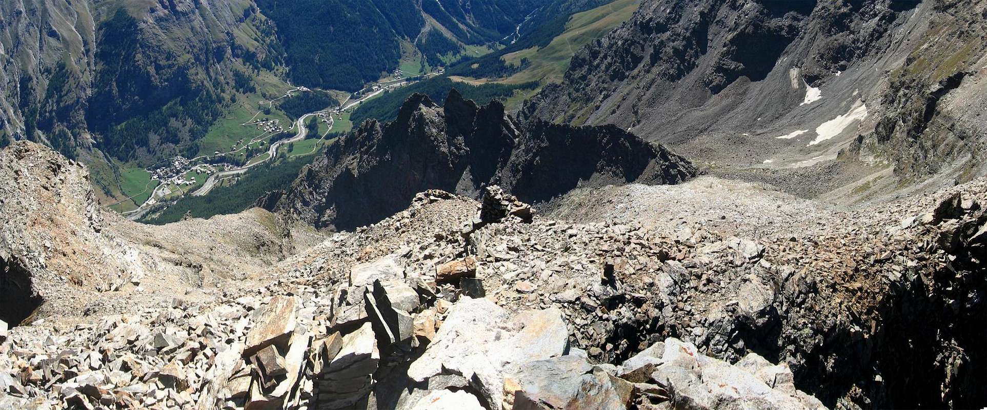
Ancient ascent, followed by an old crossing "classic" between the two World Wars, but now fallen out of fashion. Remain the ascent to Bioula from Valsavara Slope and that of La Roletta from Rhêmes, while the climbing on crest is something reserved for the few. Dedicated to mountaineers lovers of old mountains and unusual itineraries. From Valsavarenche: by Degioz Chief town (1.541m) reach to the Southwest through the trail n° 8/8b the wide "Pavillon Royal de Chasse" (2.168m); from this, flexing with a diagonal route towards the Northwest with the large and evident mule track n° 8a easily reach, after bypassing a large saddle to the West respect of the characteristic Forquin Fourquin de bioula entering a small secondary vallon, the Summit of Bioula (EE/F; 4h'00/4h'30 from Degioz Village). The entire and integral traverse on ridge presents the passages with transition from the I°/II°/II°+ to the III°-/III°+ (Tour de Notre Dame, where you should maintain the same path both uphill and downhill) and of II°+/III°- for the Clocher de Djuan. The next North Ridge leading to Punta Bianca, formed by easy rocks, is not difficult as the following traverse to the Roletta, Clocher excluded; while the descent from La Roletta can be performed with return both in Valsavarenche and Rhêmes (A/PD/PD+; 2h'30/3h'00; from 7h'00 to 8h'00 in total).
Un'ascensione antica, seguita da una vecchia traversata "classica" tra le due Guerre Mondiali, ma ormai caduta di moda. Rimangono la salita alla Bioula dal Versante Valsavara e quella de La Roletta da Rhêmes Notre Dame, mentre la traversata in cresta é cosa riservata a pochi. Per alpinisti amatori di vecchie montagne e di itinerari inusuali. Dalla Valsavarenche: dal Comune di Degioz (1.541 m) raggiungere verso Sudovest tramite il sentiero n° 8/8b il "Pavillon Royal de Chasse" (2.168 m); da questo svoltando a Nordovest con la mulattiera n° 8a arrivare facilmente, dopo aver oltrepassato una larga sella ad Occidente del caratteristico Forquin o Fourquin de Bioula entrando in un valloncello secondario, alla Vetta della Bioula (EE/F; 4h'00/4h'30 da Degioz). La traversata in cresta presenta passaggi dal I°/II°/II°+ al III°-/III°+ per la Tour de Notre Dame (dove conviene mantenere la stessa via sia in salita che in discesa) e di II°+/III°- al Clocher de Djuan. La successiva Cresta Nord che conduce alla Punta Bianca, lineare nel suo sviluppo e formata da facili rocce, non presenta difficoltà come la traversata verso La Roletta, Clocher escluso; mentre la discesa da quest'ultima può essere effettuata con rientro tramite il Col de Sort sia in Valsavarenche (attraverso un'oceanica pietraia e sentiero n°8/8B/8C) che a Rhêmes (A/PD/PD+; 2h'30/3h'00; da 7h'00 a 8h'00 in totale).
Difficulty
F for the Punta Bioula; F+ to PD-/PD+ for the various ways described just above in First Ascents.
F per la Punta Bioula; dal F+ al PD-/PD+ per le varie vie descritte appena sopra in First Ascents.
Equipment
For Hiking or for Mountaineering, preferably with rope in relation to the route to be carried out.
Da Escursionismo o da Alpinismo, meglio se con corda in relazione all'itinerario da effettuarsi.
Red Tape
All this trek is inside Gran Paradiso National Parks. Campings (only over 2.500 mt for emergency reason is allowed, until dawn) and dogs are strictly forbidden. Other permits are not required.
When To Climb
From July 'til September (in dry years even half October is good for).
Camping
Remember that free camping is forbidden (except for emergency reasons, over
2.500m, from darkness until dawn).
Mountain Condition
- You can get meteo information at the official site of the Regione Valle d'Aosta:
- Valle d'Aosta Meteo
![]()
Webcam
- WEBCAM on Aosta Valley:
- Webcam
Books and Maps
BOOKS:
- "Guida delle Alpi Occidentali", di Giovanni Bobba e Luigi Vaccarone C.A.I. Sezione di Torino Volume II (parte II), 25 Maggio 1896.
- "Guida dei Monti d'Italia-Gran Paradiso Parco Nazionale" E. Andreis, R. Chabod, M. C. Santis, Club Alpino Italiano/Touring Club Italiano, prima Ed. 1939; seconda Ed. 1963; terza Ed. 1980.
- "Gran Paradiso", G. Klotz, Ed. Bergverlag GmbH Rother, Monaco 2005 (in tedesco).
MAPS:
- Kompass "Gran Paradiso Valle d'Aosta Sentieri e Rifugi" Carta turistica 1:50.000.
- L'Escursionista Ed. Carta dei Sentieri "Valgrisenche/Val di Rhêmes" (carta n° 3) 1:25.000.
- Enrico Editore Ivrea-Aosta "Gruppo del Gran Paradiso" 1:50.000.
- I.G.C. Istituto Geografico Centrale, Torino "Il Parco Nazionale del Gran Paradiso" (carta n° 3) 1:50.000.
Important Information
Image by Buxlex
****************************************************************************************************************
Useful phone numbers
- Protezione Civile Valdostana località Aeroporto n° 7/A Saint Christophe (Ao) Tel. 0165-238222.
- Bollettino Meteo (weather info) Tel. 0165-44113.
- Unità Operativa di Soccorso Sanitario Tel. 118.


 13350 Hits
 85.87% Score
 21 Votes