
-
 6494 Hits
-
 71.06% Score
-
 1 Votes
|
|
Mountain/Rock |
|---|---|
|
|
58.26526°N / 134.23911°W |
|
|
Hiking, Mountaineering, Scrambling, Skiing |
|
|
Spring, Summer, Fall |
|
|
4210 ft / 1283 m |
|
|
Overview
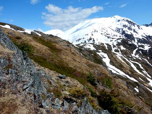
Hawthorne Peak is an 14 miles off trail hike off the Sheep Creek trail near Thane. It’s best done in the spring, summer, or fall when the trail to the cabin can easily be followed. While the hike over to Middle and West peak look close, the terrain is broken and very difficult. The summit gives you great views down Gastineau Channel and the South end of Douglass. You can also get a glimpse of the Taku Glacier to the East. There also is no 'official' trail, so route finding may be necessary.
Getting There
From Downtown Juneau, take Egan Drive South which becomes Thane Road for 4.5 miles. Parking area is on the Left side of the road near a fenced gate. 
Route
The Hawthorne Route follows the Sheep Creek trail for 2.7 miles along the well-worn path. The trail becomes unmaintained and climbs steeply for 2 miles up the hillside and to the cabin by the power lines shortly after tree line is broken and at 4,160 feet. From here Hawthorne is easily seen and generally follow the ridge towards the face. Climb up to the summit ridge and traverse to the summit. I was there in spring and had to traverse below many hanging snowdrifts. The summit is attained after 7 miles of hiking and return by hiking the same way back.

Red Tape
There is no red tape here, so please use LNT principles.
When to Climb
Mid-June through mid-September is the normal hiking season. With easy access, winter ascents would be reasonable as well, though there will be avalanche danger on the highest slopes.
May/June is when I'd recommend to climb and can be a really nice time to climb since it’s the sunniest summer month, though there tends to be more snow around.
Camping
Backcountry Camping
Permits are not needed to camp in the Tongass National Forest.