
|
|
Area/Range |
|---|---|
|
|
58.76820°N / 133.94531°W |
|
|
Hiking, Mountaineering, Trad Climbing, Toprope, Bouldering, Ice Climbing, Aid Climbing, Big Wall, Mixed, Scrambling, Canyoneering, Skiing |
|
|
Spring, Summer, Fall, Winter |
|
|
15295 ft / 4662 m |
|
|
Overview
The Alaska Coast Range extends from the British Columbia Coast Range of Canada in the South to the Saint Elias Range and Icefield Range in the North.
Topography rises from sealevel to icecaps at 3,500 feet, with most peaks around 8,000 feet, up to Mount Fairweather at 15,000 ft.
The Alaska Coast Range merges in the North with the Saint Elias Range, with boundary peaks rising from 14,000 to 18,000 feet.
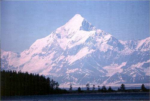 Mt. St. Elias, 18,000 feet, a few miles in from Yakutat Bay, Pacific Ocean, defining the border of Alaska, USA with Yukon Territory, Canada.
North of the St. Elias Range are the Wrangell Mountains, which extend further North into the Interior.
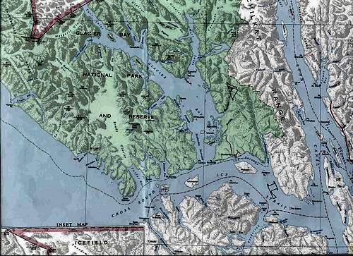
Map Coverage:
This Overview of the Alaska Coast Range addresses the regional map chart below, specifically the NW corner of Map 1F Northward to the NW corner of Map 1B. Of the 5 sub-regions listed and described below, the last sub-region, the St. Elias Mtns., is just off the top edge of the map. Another map for that area will be added soon.
Sub-region maps shown here are discussed in sequence from South to North. The last section moves West to Glacier Bay and Mt. Fairweather, with some discussion of the more Northerly ranges, before finishing with the St. Elias Sub-Region.
These maps from the British Columbia Government are at a scale of 1:600,000. Elevations are in meters. See also TopoZone maps in left margin. To center on Juneau Icefields and Devil's Paw, select TopoZone map at 1:1,000,000, and click one screen North with margin arrowheads.
Map details can be read more clearly by double-clicking twice to zoom in. Further zoom, up to 400% or more should be possible with mouse roller or image software.
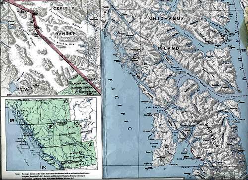
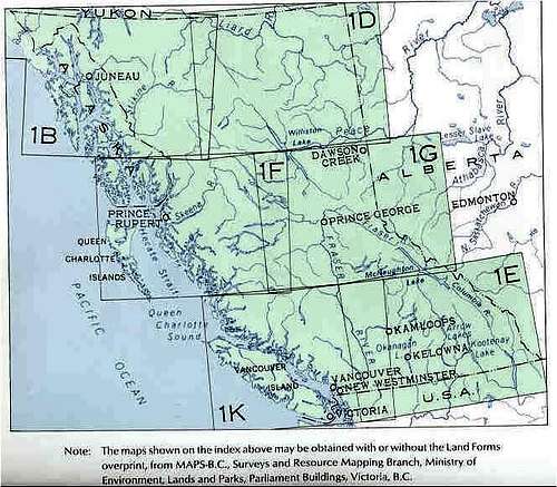 British Columbia Map Series, also showing Southeast Alaska Coast Range and Yukon.
Sub-Region 1: Southern Alaska, around Ketchikan and Misty Fiords, by the BC Canada border.
Sub-Region 2: Stikine Icefield between Wrangell and Petersburg.
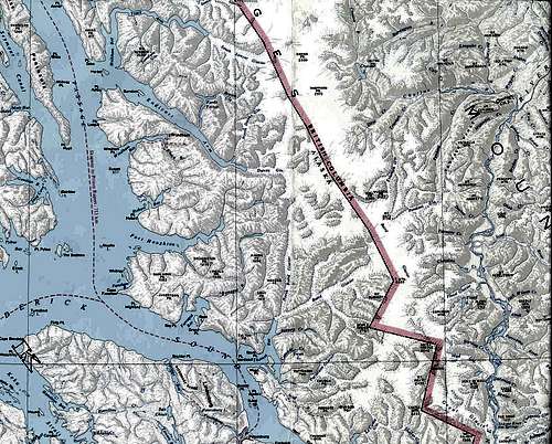
Sub-Region 3: Juneau Icefield, from the Taku River north to Skagway's Chilkoot Pass over to Lake Atlin, and Whitehorse, Yukon Territory.
Sub-Region 4: Glacier Bay and The Icefield Ranges,withMt. Fairweather.
Sub-Region 5: The St. Elias Mountains, on the border between Alaska & The Yukon Territory, Canada.
North of here the Coast Range transitions into the Wrangell Mtns. east of Prince William Sound and the Copper River, which drains the frigid Interior. That zone is preserved now as Wrangell-St.Elias National Monument. A separate Summitpost "Regions" webpage exists for the Wrangell Mountains.
Climate Warning:
The many glaciers of this uplift range are due to the severe year-round storms that blow in off the North Pacific and Gulf of Alaska. This is a rainforest, with precipitation exceeding 200 inches per year in some places. The steep mountains force the rainclouds to the point of condensation and hold them in one place for weeks on end - sometimes months on end.
There are more cyclonic storms hitting the Coast Range than anywhere else on earth, except the Straits of Magellan off Patagonia at the tip of South America.
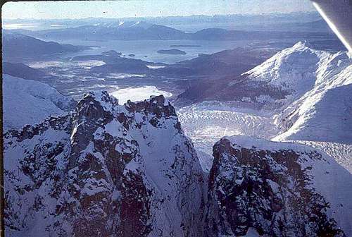
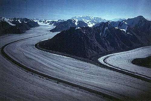
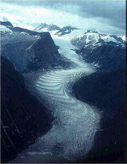 East Twin Glacier descending from Juneau Icefield into Twin Glacier Lake.
Gear Warning:
During the course of a climb from tidewater one will go from rain up into snow. So, depending on the weather, one might have to wear impermeable slickers and rainpants to keep out the rain. GoreTex can be too permeable in the steady heavy rains. Wool and/or fleece are often worn beneath fishermen's rain gear in lower elevations.
Thinsulate or other synthetics will be more useful once one climbs up into the higher elevations. Through the transition zone of freezing rime into wet and heavy snow, synthetics will be useful for sleeping bags as well.
Because down sleeping bags are nearly useless when wet they should not be used except for winter trips.
Likewise tents should be rigged with flies, seam sealing and extra snow flukes or pickets for deep snow in high winds. A wind meter set up on Mt. Juneau blew down and the last measurement was at over 200 miles per hour.
GEOGRAPHY:
This section addresses sub-regions from South to North. So we start from the Canadian boundary, on the green maps above, Map 1F, just above Prince Rupert, British Columbia. This sub-region covers Misty Fiords National Monument near Ketchikan to the Stikine Icefields near Petersburg. The second sub-region addresses the Stikine Icefields. The 3rd sub-region is the Juneau Icefield, from Taku River to Skagway, to Atlin, BC. The 4th sub-region moves Westward over the Chilkat Mountains to Glacier Bay National Monument near Sitka, and NW up into the St. Elias Range, near the Yukon Territory of Canada.
SUB-REGION 1: SOUTHERN ALASKA COAST RANGE: BC to Stikine Icefields:
On the Southern border the region stretches from Hyder Alaska, near Ketchikan, on the same fiord as Stewart, British Columbia, on the Bear River. The fiord is Portland Canal,entering the Inside Passage near the Queen Charlotte Islands of B.C. Behind Ketchikan, the Misty Fiords National Monument provides saltwater access, via seaplane or charter cruiser out of Ketchikan.
 Southern Alaska Coast Range, behind Ketchikan and Misty Fiords National Monument.
The Coast Range actually starts in British Columbia Canada near Vancouver, as a Northward extension of the Cascades of Washington State, part of the Pacific Rim of Fire volcano chains.
From Ketchikan, Alaska, the Alaska Coast Range extends Northward past Wrangell, Alaska, at the mouth of the Stikine River. The Stikine originates in the Interior of BC, and cuts through the Coast Range to Alaska.Icefields drape the shoulders of the mountain ranges, with glaciers digging deep canyon troughs down to the rivers, lakes and saltwater fiords of the Inside Passage.
Climbing:
The smooth icecaps are punctuated by nunataks (rock spires), granite peaks, and even granite sub-range massifs. Glaciers roll over the edges of the underlying cliffs in plastic fluidity, breaking up into icefalls, rather than waterfalls.
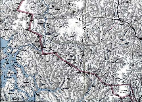
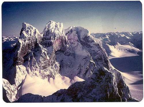
 Petersburg, Devil's Thumb, Kate's Needle.
SUB-REGION 2: STIKINE ICEFIELDS.
North of Ketchikan, the Stikine Icefields reach up almost to the Taku River in the North. Petersburg is on an island facing east, toward Thomas Bay, where the Baird Glacier flows down in several arms into the sea. Prominent peaks worthy of note include Kate's Needle, Mount Katz, Rabbit Ears Spire, as well as Devil's Thumb. Many of these were climbed by Fred Beckey, and some, like Devil's Thumb, by David Roberts, are reported in their guidebooks and articles, including the American Alpine Journal and other books, like "EPIC." (see full cite below).
Fiords & Steep River Vallies from Glaciers Makes Rescue Difficult:
Several sub-ranges collide in the region. Some of these deep river canyons flow North on the other side of the crestline, into West-flowing rivers.
So climbers should plan routes carefully, noting the elevation changes and slopes for any vallies that have to be crossed.
 Steep river canyon cliffs and tidewater reaches prevent walking out to towns.
Some fiords have such dramatic granite walls that they resemble a drowned Yosemite. One such place is Endicott Arm and Tracy Arm. These fiords start in a common bay, then split, and follow up separate fiord canyons. Tracy Arm is navigable only at high tide, due to being perched above sea level. Glaciers at their heads can provide access to the high icefields. Or one can just charter a ski-plane from one of the communities.
Contingency plans for retreat, route changes, pickup points by boat or aircraft, and evacuation in case of accident should be made ahead of time. Few people are back in these places. One has to be reliant on understandings with their bush pilot. But when the weather lowers in, and the pilot can not land due to fog, wind, rain or snow conditions, a climber or group might have to just head out walking. Injuries would make that problematic in these extreme weather conditions without a satellite phone.
Even if you hike out to tidewater, you cannot swim across it, and days can pass without a boat coming by. Those boats' pilots might might not see you, or be effective in communicating your position to rescue teams.Accordingly, extra food caches should be set up, and emergency rescue radios or satellite phones carried. Weather here is so severe that aircraft might not be able to get in to find you or get in to you for days.
SUB-REGION 3: JUNEAU ICEFIELDS:
The Taku River cuts through the Coast Range from the Canadian Interior, emerging into the Inside Passage between Petersburg and Juneau.
North of the Taku River is the 1400 square mile Juneau Icefield. It is perched at 3,000 feet elevation as an ice cap over the mountain range. Glaciers descend from the granite spires to the East into Lake Atlin, and to the West down the Mendenhall Glacier into Juneau's outlying suburbs.
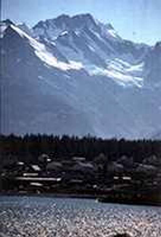
 Mendenhall Towers above the town of Juneau, West by Northwest toward the Chilkats, Glacier Bay, and the Fairweather Range.
 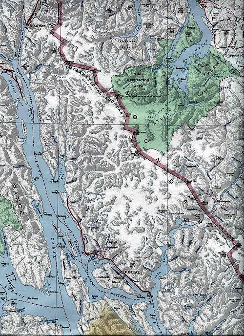 Northern Juneau Icefield to Skagway and East to Atlin Lake, BC.
This image of Devil's Paw was shot on a bushplane flight 20 minutes ESE downtown Juneau. (Note that the corresponding spire called "Devil's Thumb" is some 30-50 miles South, near Petersburg, across the Taku Canyon, on the Stikine Icefield. See Sub-region 2, above.)
 Devil's Paw, Juneau Icefields, above th Taku River, defining the border between Alaska USA and British Columbia, Canada.
For more detailed information on the hiking around Juneau contact the Juneau Alpine Club.
For more on technical climbing opportunities see "External Links" at the end of this webpage, especially "Climbing Mendenhall Towers," and Foggy Mountain Shop.
SUB-REGION 4: GLACIER BAY, MT. FAIRWEATHER & THE ICEFIELD RANGES:
Glacier Bay is the corner between the Inside Passage of the Alexander Archipelago of forested islands, including Sitka, out Icy Strait to the Outside Coast, on the Gulf of Alaska near Yakutat. The head of the Inside Passage, with relatively warm maritime air hits the high peaks at 14-15,000 ft. and turns all that warm moist air from the Japanese Current into heavy condensation, falling as snow, building up into glaciers at Glacier Bay. These flow down into saltwater in fiords, offset now by ablation, the loss of glacier to heating of climate change.
Glacier Bay is bounded in the East by the Chilkat Mtns., which is the western boundary of Lynn Canal, the final fiord of the narrowing Inside Passage from Chatham Strait. Glacier Bay National Monument's watershed is really more of an ice-shed. With the Chilkat Mtns. as the eastern wall, the back wall consists of the rim of the Takhinsha Mountains behind Haines, Alaska. This back rim of the bowl wraps around to the West, all the way to the Outside Coast on the wild Pacific's waves breaking on sandy shores.
 Haines, Alaska, looking West into the Takhinsha Mtns, which keep trending West to form the Northern rim of Glacier Bay, to the Outside Coast along the Alsek River.
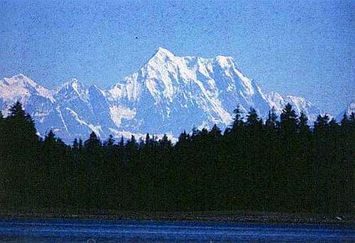
The West wall of the Glacier Bay bowl's rim is the Fairweather Range, capped by Mt. Fairweather at 15,000 ft. This range's peaks drop straight down into the Pacific Ocean at LaPerouse Bay, and extend up the Outside Coast to the Alsek River at Dry Bay.
 Glacier Bay and Fairweather Range to Outside Coast.
From the Alsek River the North-trending Brabazon Mtns. form a backdrop to the coastal plain. Behind the Brabazons are massive glacier vallies, which then pop up into the Icefield Ranges of BC and The Yukon Territory. The Icefield Ranges are on the Southwest side of Kluane National Park near Whitehorse. The Tatshenshini River arises in the Yukon-Alaska borderlands and cuts through these mountains to join the Alsek.
For more photos of this world-class scenery, see links on pages to related websites of river outfitters and pilots.
SUB-REGION 5: THE ST. ELIAS MOUNTAINS:
Mt. St. Elias dominates this range, as it should at 18,000 ft. But there are also several other major peaks worthy of attention, 14,000 ft and higher. These include the Boundary Range peaks of Mt. Augusta, Mt. Seattle, Mt. Vancouver, and Mt. Logan.
 Access to the St. Elias Mtns up the Kaskawulsh Glacier from the drier East side, Kluane Lake, near Whitehorse, Yukon.
Most are approached from the Yukon side because of the hoary weather on the Pacific cyclone side, stacking up and dropping snow for months at a time. These photos were shot after several weather-cancelled efforts, on the first sunny day in 6 months.
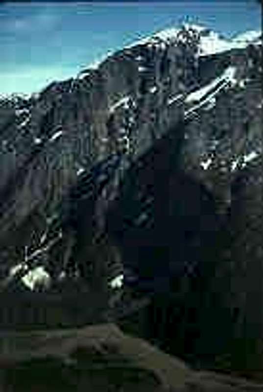
 Mt. Augusta, a Boundary Range Peak south of Mt. St. Elias, near Yakutat, Alaska.
 Getting There:
Alaska Airlines and other carriers fly into the regional centers with jets. Regional airlines fly to most rural communities and Native villages.
Access by tidewater is by boat up fiords from the Inside Passage of Alaska. Access from the Canadian Interior is up river canyons and dirt trails from the Alaska-Canada "Highway" in British Columbia and Yukon Territory.
Float planes and ski planes can be chartered in most communities. In some communities, mining camps or logging centers helicopters can often be chartered. (See "External Links Below.)
Kayaking up the Inside Passage has been done in 40 days from Seattle. Small motorcraft, as well as sailboats are better modes for climbers with gear.
Jetboats can be chartered for runs up the Stikine from Wrangell, and up the Taku from Juneau.
Roads now ascend the Bear River Canyon from Stewart BC to Meziadin Lake, with access to both the Salmon Glacier behind Hyder Alaska, and to the Cambrian Ice Cap via the Bear Glacier in BC. One can access that by Alaska Ferry from Bellingham, BC Ferries from Vancouver or other port cities like Kitimat and Prince Rupert down the Skeena River from the Alcan.
Fishing boats, plane or helo can be chartered in Petersburg to the mainland to approach via Baird Glacier to Devil's Thumb and other spires on the US-Canadian border with BC.
A new road may also be built soon up the Taku River Canyon to serve mines proposed for the region. A road now ascends from Skagway to Whitehorse, YT.
A road also ascends from Haines Alaska up the Klehini River past Pleasant Camp border crossing, over Three Guardsmen's Pass into Kluane National Park, Yukon. It connects with the Alcan at Haines Junction.
River float trips can be arranged by charter to descend some of these rivers, both by raft and by jetboat. Charter companies and group scheduled trips work out of both the Canadian provincial centers and local communities.
A climbing expedition might be able to arrange a raft-in for drop-off on one trip, and then to be picked up a week or two or 4 later, by another trip. (It should be by the same operator, to assure detailed knowledge of exact pickup spot, and faces.)
Outside Passage:
From the Alsek River on the Outside Coast south of Yakutat, to the Copper River near Cordova, no river cuts through the entire St. Elias Range. Most rivers are short drops from receding glaciers to the sea through thick coastal forest. Icy Bay, beneath Mt. St. Elias, has a logging camp.
Some remote areas near there provide outrageous surfing. However, one must beware of logs in the curl with you, and grizzly bears coming out of the thick woods behind, often unheard in the noise of the coastal wind and booming surf.
Red Tape
Agencies:
Permits are required by the National Park Service and Parks Canada, within the formal boundaries of their jurisdictions. Inquire at agency offices, or at their websites.
US Forest Service and Bureau of Land Management are more relaxed about access to forest land for the most part, but new rules arise often, and one should check out local guidebooks.
See also State and provincial agencies, like the Department of Natural Resources, Fish & Game, and BC Ministry of Environment. Fishing permits are required, and tags for both hunting and fishing for some species. Access to certain areas, like the Pack River Bear Preserve on Admiralty Island, also require advance lottery selection.
Native Corporations and Allotment Owners:
A major issue among both Alaska Natives and Canadian First Nations groups is land claims to traditional lands. A variety of tribal and corporate laws have been passed to create special rights to traditional lands.
As part of the Alaska Native Claims Settlement Act 13 regional corporations and over 100 village corporations were created to convey both traditional and exchanged lands from the federal government prior to conveyance of all State of Alaska claims, pending since statehood. So one should find out where Native lands are located, and get permission before trespassing. Easements are available in some areas, for state public use rights of way.
The Indian Reorganization Act of 1926 allows individual natives to claim private allotments, based on traditional use. Many of these are along coasts, rivers and lakes, for traditional hunting and fishing activities. These are private lands. Access via water or air is the best way to avoid conflicts of use.
In some areas one might become liable to tribal jurisdiction for infractions, if within areas of their jurisdiction.
Entitlement to many land claims has already been transferred to Native groups and individuals. Therefore that is private property, and trips should be planned to ensure that you not trespass on Native corporation lands, tribal lands, or private allotments or mining claims.
Many of the village and regional corporations have extensive economic interests in mining, timber logging, tourism, and fisheries that mountain climbers should be aware of and respect.
Landowners in some areas have pledged to protect trespass against private property rights as groups and individual landowners from the Lower 48. Some might allow access for a fee, or even provide charter or scheduled group trips to help you achieve your climbing objectives.
External Links
Juneau Icefieldld glaciers and Google Earth photos, by Mauri Pelto and Maynard Miller, Juneau Icefield Research Program.
Helicopter charters from Juneau.
Chilkat Guides, for access to Chilkat Range between Glacier Bay National Monument, Haines, and Yakutat, near Mt. Saint Elias.
Photos of Taku River Watershed, south side of Juneau Icefield, by National Geographic.
Camping
Forest Service campgrounds are available near most of the regional communities, like Juneau.
The US Forest Service also has A-frame cabins for rent, in several areas. (e.g. Hasselborg Lake on Admiralty Island.) No great climbing destinations are near that particular cabin, but there are others on the mainland, which are closer to peaks.
For those who are willing to climb less than the highest or most dramatic of peaks for the record books, there are many peaks on places like Admiralty Island that would be interesting achievements in the Lower 48. In such a dramatic environment as Alaska they do not gain much attention, so there are opportunities to make first ascents, or even to get a peak named.
Other Wildlife
Marine mammal migrations are one of the highlights of the Alaska Coast Range. Whales headed for the Arctic, and Glacier Bay breed and eat all along the inlets, bays and deepwater passages of this living sea, making it a dynamic experience. A humpback whale might rise right beside your craft, and sound to depth while trailing its flukes and rudder-like tail planes right past you. So be aware, and have your camera ready.
There are also incredibly immense schools of smelt that pool up and breed with milt so thick it turns the ocean milky white. Incoming migrations of whales, salmon, sea lions, and seals feed on them.
Also beware of orca killer whales, which in their pursuit of seals, may chase a terrified herd right up out of the water and onto the dock.
Fishing with a handline, without a rod, is also possible, with a permit.
Generally dipnetting or trapping of fish is not allowed for visitors.
Major mining proposals in many of these places are in the works now. Websites of state and federal agencies, mining companies and environmental organizations share their differing perspectives on the benefits and impacts. Beware helicopter mining exploration, road surveys, logging, etc.
See especially earth.google.com for hybrid satellite photos and mapped transportation routes like ferries. Zoom right in on your climbing destinations, and link to the ground-or-water level photos of outfitters you discover on search engines.
Native Cultures
Several cultures and sub-cultures make climbing trips to Alaska interesting. People one meets on a river or coast may be hunting from their village, or trading with another community, on the other side of the mountains, in a traditional commerce exchange of subsistence or commercial use of foods or crafts.
LANGUAGE GROUPS, CLANS, and POLITICS:
Among Native cultures, there are mostly Indian peoples descended from the Athabaskan language group. The range of this language group descends from the Interior of Alaska down through Western Canada and the Rockies, into Arizona and Mexico. So Apaches of Arizona and Mexico are related distantly to the Doyon Indians of the Koyukuk in the Brooks Range to the Upper Tanana (major tributary of the Yukon) and to other Native groups down through Alberta, Montana, Wyoming and Colorado, by language and culture.
ANTHROPOLOGICAL HISTORY:
Some anthropologists believe the Athabascan language group was one of several in-migrations of peoples across the Bering Land Bridge, when it connected Siberia to the Seward Peninsula near Nome and Kotzebue.
The Athabaskans may have migrated in during a long period of relatively few other peoples, as they spread out over such a vast distance. They might have been followed later by a wave of in-migrants, from another region of Asia, now known as Eskimo (Yupik in Western Alaska, Inupiaq in the NW and North, and as Inuit in Canada.
In Southeast Alaska's Coast Range, the Indians consist of Tlingit, and in the far Southeast, the Tsimpshians. These merge into the region of the Kwakiutl in British Columbia.
Each has sub-groups, such as the Tlingit Chilkats near Haines. Their land use ranges from mountain goat wool woven for decorative blankets for potlatch ceremonies, to abalone shell on the tidelands for decoration of cedar helmets with white ermine.
So when one is in the mountains of this region one should be aware that the local people have value systems about land use patterns and resource use which might not be predictable without local knowledge gained from inquiry, or at least being alert to the need to ask questions.
MOUNTAIN RANGE INFLUENCE ON CULTURES:
Mountain ranges blocked travel, narrowing traditional travel to river canyons. River canyons like the Stikine and Taku provided trade routes to the Interior villages like Teslin, where today some people say that they have distant relatives out on the coast, and still get together to trade.
Mountain climbers should be sure to respect both the cultural privacy of groups who may have gotten overly tired of tourists, to groups which would like to have you purchase local products for their income source.
Please be careful about disturbing old grave sites that you might encounter, and traditional fishing camps along rivers. They have legally protected rights of ownership or land use at most of those sites, by federal law and sovereign nation law.
Maps of land ownership can be obtained from state and federal agencies. The BLM (US Bureau of Land Management) is in charge of land claim conveyances, and their maps are usually the most wide-ranging and up-to-date.
Have FUN!
Related Reading
For a trip report and photo of the Devil's Thumb, including proof of why you should not try to walk out, read: "The Devil's Thumb," by Jon Krakauer, pp. 4-26, in EPIC: Stories of Survival From The World's Highest Peaks, edited by Clint Willis, Adrenaline imprint, Thunder's Mouth Press and Balliet & Fitzgerald Inc, New York, 1997. ISBN 1-56025-154-9.